
Delhi has significant reliance on its transport infrastructure. The city has developed a highly efficient public transport system with the introduction of the Delhi Metro, which is undergoing a rapid modernization and expansion since 2006. There are 16.6 million registered vehicles in the city as of 30 June 2014, which is the highest in the world among all cities, most of which do not follow any pollution emission norm, while the Delhi metropolitan region has 11.2 million vehicles. Delhi and NCR lose nearly 42 crore man-hours every month while commuting between home and office through public transport, due to the traffic congestion. Therefore, serious efforts, including a number of transport infrastructure projects, are under way to encourage usage of public transport in the city.
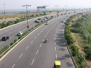
The Delhi–Noida Direct Flyway or DND Flyway is India's first 8-lane wide, 7.5 km (4.7 mi) long access-controlled expressway in Delhi NCR. It connects Maharani Bagh and Nizamuddin on the western side to Noida (Sector-15A) and Mayur Vihar on the eastern side of the Yamuna river. The Noida Toll Bridge Company Limited (NTBCL) owned by IL&FS, operate and maintains it on build-own-operate-transfer (BOOT) basis. The expressway, which was opened to the public in January 2001 was constructed by Japan based Mitsui-Marubeni Corporation Ltd. The length of main carriageway (MCW), including bridge on Yamuna river is 6.0 km. Rest 1.5 km is Mayur Vihar link (MVL), which was opened in 2008.

Okhla is an urban neighbourhood located near the Okhla barrage in the South East Delhi district of Delhi near the border between Delhi and Uttar Pradesh. Okhla has lent its name to the nearby planned township of New Okhla Industrial Development Authority or NOIDA. Okhla is also an assembly constituency.
Delhi, a major metropolitan region of India, is connected to various parts of country through several national highways and expressways. All the highways and expressways from Delhi lead to Haryana or Uttar Pradesh and continue from there.
The Western Peripheral Expressway (WPE) or Kundli–Manesar–Palwal Expressway, is an operational 6-lane, 135.6 km (84.3 mi)-long Expressway in the Haryana state of India. Along with the Eastern Peripheral Expressway, the Western Peripheral Expressway is expected to divert more than 50,000 heavy vehicles away from Delhi, which will help to maintain good air quality in Delhi. Western Peripheral Expressway along with Eastern Peripheral Expressway completes the largest Ring Road around Delhi. There are 10 tolled entries and exits, from north to south - Kundli, Kharkhoda, Bahadurgarh, Badli, Fartukhnagar, Panchgaon, Manesar, Taoru, Sohna & Palwal. Toll rate notified in December 2018 is INR1.35 per km for cars, INR2.18 per km for light motor vehicles, INR4.98 per km for trucks and buses, and two wheelers are not permitted on the expressway.
Kapashera Border is one of the main Borders of Delhi. It connects Delhi to Gurugram district of Haryana state. The road connecting two said cities is referred to as Old Delhi-Gurgaon Road.

Okhla Bird Sanctuary is a bird sanctuary at the Okhla barrage over Yamuna River. It is situated in Noida, Gautam Buddh Nagar district, on Delhi-Uttar Pradesh state border and known as a haven for over 300 bird species, especially waterbirds. In 1990, an area of 3.5 square kilometres (1.4 sq mi) on the river Yamuna was designated a bird sanctuary by the Government of Uttar Pradesh under the Wildlife Protection Act, 1972. The site is located at the point where the river enters Uttar Pradesh. The most prominent feature of the sanctuary is the large lake created by damming the river, which lies between Okhla village to the west and Gautam Budh Nagar to the east. The Okhla Bird Sanctuary (OBS) is roughly 4 square kilometres in size and is situated at the entrance of NOIDA in Gautam Budh Nagar district of Uttar Pradesh. It is situated at a point where river Yamuna enters in the state of Uttar Pradesh leaving the territory of Delhi. It is one among fifteen bird sanctuaries in the state.
The Faridabad–Noida–Ghaziabad Expressway or FNG Expressway is an under-construction 56 km long, 6-lane wide expressway in Delhi NCR region of India. It will connect Faridabad in Haryana with Noida and Ghaziabad in Uttar Pradesh.

Shaheen Bagh is a neighbourhood in the South Delhi district of Delhi, India. It is on the U.P border and southernmost colony of the Okhla area, situated along the banks of the Yamuna. The locality is known for being the site of gathering for the protest against the Citizenship (Amendment) Act (CAA), National Register of Citizens (NRC) and National Population Register (NPR). Shaheen Bagh is recognized as one of the areas in Delhi with a significant Muslim population.
The Noida–Greater Noida Expressway is a six-lane expressway connecting Noida, Uttar Pradesh, an industrial suburb of Delhi to Greater Noida, a new suburb. This expressway is under expansion to Taj Economic Zone, International Airport and Aviation Hub proposed to be constructed along the Yamuna Expressway. The expressway is 24.53 km (15.24 mi) long, built at a cost of ₹400 Crore to relieve the old Delhi-Agra national highway (NH-2) which was already congested and ran through the heart of cities like Faridabad, Ballabhgarh and Palwal.
Badarpur is a historical town situated in the South East Delhi district of National Capital Territory of Delhi, India. The area of Badarpur encompasses both an NTPC thermal power station and an ancient village known as Badarpur village. The village is mostly dominated by Gujjars.
Okhla Vihar is a new settlement in Okhla, in the district of South East Delhi, India. It consists of many lanes (roads) and many sub-lanes (sub-roads). Over 80% of the area of Okhla Vihar is covered with 5-story apartments. The area consists of three mosques and a church. Amanatullah Khan is the local M.L.A from AAP.

The Okhla Vihar metro station is located on the Magenta Line of the Delhi Metro. It is located in Abul Fazal Enclave just behind Jamia Nagar Police station. This Metro station has three gates. One named as Abul Fazal Enclave Part-I another Hari Kothi Road and the last one as Jamia Nagar Police Station.

The Okhla Bird Sanctuary metro station is located on the Magenta Line of the Delhi Metro. It is located near the Okhla Bird Sanctuary, which is one of the 466 IBAs of India.

The Okhla barrage is a 791 meters or roughly 800-yard long weir across Yamuna River opened in 1874. It also serves as the location of Okhla Bird Sanctuary today. It is situated 10 km to the south of New Delhi and downstream of Nizamuddin bridge at Okhla, where Agra canal originates from it. The top of barrage also serves as the Delhi-Noida carriageway of Kalindi Kunj-Mithapur road. Nearby later-era New Okhla Barrage is 554 meters long.
The Delhi–Mumbai Expressway is a 1,350 km long, 8-lane wide under-construction access-controlled expressway connecting India's national capital New Delhi to its financial capital Mumbai. The foundation stone for the project was laid by union minister Nitin Gadkari in the presence of Sushma Swaraj and Arun Jaitley on 8 March 2019 and is inaugurated by PM Modi. The total project value including the land acquisition cost is around ₹1,00,000 crores .
JJ Colony is a resettlement colony on the Gram Sabha Land of Madanpur Khadar Village in the south-eastern region of Delhi. It is located in close proximity to Sarita Vihar and Kalindi Kunj, about 1 kilometers from the Uttar Pradesh border. It was created in 2004 when the slum dwellers from across Delhi were forcefully evicted and relocated to the urban peripheries. Since its formation, the community has undergone massive structural, political, economic, and social changes affecting the lives of the community. The transformation of JJ Colony in Khadar is underscored by several challenges ranging from the provision of basic amenities, mobility, and the condition of women's safety. From then to now JJ colony in khadar has changed much from the lanes of agriculture canal to road channels has come far bit.
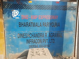
The DND–Faridabad–KMP Expressway, formally known as NH-148NA is a 59 km long, 6-lane wide access-controlled expressway in Delhi NCR, India. It connects the junction of DND Flyway and Ring Road at Maharani Bagh in Delhi with KMP Expressway at Khalilpur, Nuh district in Haryana. The NH-148NA is a spur (branch) of Delhi–Mumbai Expressway project. This expressway will have an additional 31 km long spur from Sector-65, Faridabad bypass to Jewar Airport.

Madanpur Khadar is an urban village in South East district of Delhi. It is located on Delhi-UP Border and is an 800 years old village, named after Thakur Madan Singh Chauhan. The term Khadar is attached to the village’s name because it is situated on the banks of Yamuna river. It was declared as an urban village by the administrative authorities under Delhi Metropolitan Council in 1966.
Urban Extension Road-II or NH-344M is an upcoming 75.7 km long, 6 lanes & 6 lanes wide grade separated expressway in Delhi NCR, India. It would start from National Highway 44 at Alipur then passes from Rohini, Mundka, Najafgarh, Dwarka and end at Delhi–Gurgaon Expressway on National Highway 48 near Mahipalpur. Its main route forms a semicircle on the western side of Delhi, additionally it has two side spurs - one from Bawana in Northwest Delhi to Sonipat in Bawana's North and second in west Delhi from between Tikri border & Najafgarh to NH9 Bahadurgarh south bypass. Delhi NCT has 4 concentric ring roads around it - namely Inner Ring Road; Outer Ring Road; third ring outside it formed by the combination of UER-II & Chilla-Okhla Expressway, and fourth ring formed by the combination of part of Dwarka Expressway & Gurugaon-Ghata Expressway, Gurgaon-Sohna Elevated Corridor Expressway, Sohna-Faridabad section of Delhi–Mumbai Expressway, Faridabad–Noida–Ghaziabad Expressway (FNG), Ghaziabad-Narela Expressway (planned) and Rai-Narela-Bahadurgarh-Gurgaon Expressway. Outside these ring roads, NCR region will have 3 Regional Circular Expressways and 3 Zonal Circular Expressways (ZCE).
