Skipton and Ripon (UK Parliament constituency)

Last updated

Skipton and Ripon
County constituency
for the House of Commons
SkiptonRipon2007Constituency.svg
Boundary of Skipton and Ripon in North Yorkshire
EnglandNorthYorkshire.svg
Location of North Yorkshire within England
County North Yorkshire
Electorate 77,541 (December 2019) [1]
Major settlements Masham, Ripon, Settle, Skipton
Current constituency
Created 1983
Member of Parliament Julian Smith (Conservative)
SeatsOne
Created from Skipton, Ripon, Harrogate, Thirsk & Malton, Keighley, Barkston Ash and Richmond (Yorks) [2]

Skipton and Ripon is a constituency [n 1] in North Yorkshire represented in the House of Commons of the UK Parliament since 2010 by Julian Smith, a Conservative. [n 2]

Contents

Constituency profile

The constituency covers a mainly rural area of the Yorkshire Dales. The largest settlements are the town of Skipton and the city of Ripon. Smaller towns in the constituency are Bentham, Settle, Pateley Bridge and Masham.

It is one of the safest seats in England, formed on an area with a long history of Conservative representation and with a large majority of its electorate having in the last election voted Conservative. It was also the constituency in 1992 that when declared, saw the Conservatives gain the 4th straight majority since 1979 and John Major re-elected as Prime Minister.

At 1.6%, Skipton and Ripon had significantly lower than national average unemployment (3.8%) in November 2012. [3]

This area of the Yorkshire Dales covers the whole of the former Craven district and the northern and western parts of the former Borough of Harrogate district.

Boundaries

Skipton and Ripon (UK Parliament constituency)
Map of boundaries until 2024

1983–1997: The District of Craven, and the Borough of Harrogate wards of Almscliffe, Bishop Monkton, Boroughbridge, Fountains, Killinghall, Kirkby Malzeard, Lower Nidderdale, Mashamshire, Newby, Nidd Valley, Pateley Bridge, Ripon East, Ripon West, Wathvale, and Wharfedale Moors.

1997–2010: The District of Craven, and the Borough of Harrogate wards of Almscliffe, Bishop Monkton, Fountains, Killinghall, Kirkby Malzeard, Lower Nidderdale, Mashamshire, Nidd Valley, Pateley Bridge, Ripon East, Ripon West, and Wharfedale Moors.

2010–2024: The District of Craven, and the Borough of Harrogate wards of Bishop Monkton, Kirkby Malzeard, Lower Nidderdale, Mashamshire, Newby, Nidd Valley, Pateley Bridge, Ripon Minster, Ripon Moorside, Ripon Spa, Washburn, and Wathvale.

From 2024

Further to the 2023 Periodic Review of Westminster constituencies, enacted by the Parliamentary Constituencies Order 2023, from the 2024 United Kingdom general election, the constituency was to be composed of the following (as they existed on 1 December 2020):

With effect from 1 April 2023, the second tier authorities in the county of North Yorkshire were abolished and absorbed into the new unitary authority of North Yorkshire. [5] The constituency therefore now comprises the following electoral divisions of North Yorkshire from the 2024 general election:

The southern part of the Wathvale & Bishop Monkton division (including the parish of Bishop Monkton) has been transferred to the new constituency of Wetherby and Easingwold.

History

The constituency was created in 1983 from the parts of the former seats of Skipton and Ripon within the county of North Yorkshire.

Members of Parliament

ElectionMember [7] Party
1983 John Watson Conservative
1987 David Curry Conservative
2010 Julian Smith Conservative

Elections

Skipton and Ripon election results Skipton and ripon.png
Skipton and Ripon election results

Elections in the 2020s

General election 2024: Skipton and Ripon
PartyCandidateVotes%±%
Labour
Green Andy Brown [8]
Reform UK Simon Garvey [9]
Conservative Julian Smith [10]
Majority
Turnout
Swing

Elections in the 2010s

General election 2019: Skipton and Ripon [11]
PartyCandidateVotes%±%
Conservative Julian Smith 34,919 59.5 ―3.2
Labour Brian McDaid11,22519.1―9.2
Liberal Democrats Andrew Murday8,70114.8New
Green Andy Brown2,7484.7―1.7
Yorkshire Jack Render1,1311.9―0.7
Majority23,69440.4+6.0
Turnout 58,72474.6+0.2
Conservative hold Swing +3.0
General election 2017: Skipton and Ripon [12]
PartyCandidateVotes%±%
Conservative Julian Smith 36,425 62.7 +7.3
Labour Alan Woodhead16,44028.3+10.9
Green Andy Brown3,7346.4+0.7
Yorkshire Jack Render1,5392.6New
Majority19,98534.4―3.6
Turnout 58,13874.4+6.8
Conservative hold Swing ―1.8

In 2017, the Liberal Democrats stood aside and endorsed the Green Party. [13]

General election 2015: Skipton and Ripon [14] [15]
PartyCandidateVotes%±%
Conservative Julian Smith 30,248 55.4 +4.8
Labour Malcolm Birks9,48717.4+7.4
UKIP Alan Henderson7,65114.0+10.5
Liberal Democrats Jacquie Bell4,0577.4―25.0
Green Andy Brown3,1165.7New
Majority20,76138.0+19.8
Turnout 54,55971.6+0.9
Conservative hold Swing ―1.2
General election 2010: Skipton and Ripon [16] [17]
PartyCandidateVotes%±%
Conservative Julian Smith 27,685 50.6 +0.6
Liberal Democrats Helen Flynn17,73532.4+5.8
Labour Claire Hazelgrove 5,49810.0―8.2
UKIP Rodney Mills1,9093.5―1.1
BNP Bernard Allen1,4032.6New
Independent Roger Bell3150.6New
The Youth PartyDylan Gilligan950.2New
Virtue Currency Cognitive Appraisal Party Bob Leakey 840.2―0.4
Majority9,95018.2―4.8
Turnout 54,72470.7+4.6
Conservative hold Swing ―2.6

Elections in the 2000s

General election 2005: Skipton and Ripon [18]
PartyCandidateVotes%±%
Conservative David Curry 25,100 49.7 ―2.7
Liberal Democrats Paul English13,48026.7+0.6
Labour Paul Baptie9,39318.6+1.2
UKIP Ian Bannister2,2744.5+0.3
Virtue Currency Cognitive Appraisal Party Bob Leakey 2740.5New
Majority11,62023.0―3.3
Turnout 50,52172.6+6.5
Conservative hold Swing
General election 2001: Skipton and Ripon [19]
PartyCandidateVotes%±%
Conservative David Curry 25,736 52.4 +5.9
Liberal Democrats Bernard Bateman12,80626.1+0.9
Labour Michael Dugher 8,54317.4―5.0
UKIP Nancy Holdsworth2,0414.2New
Majority12,93026.3+5.0
Turnout 49,12666.1―8.6
Conservative hold Swing

Elections in the 1990s

General election 1997: Skipton and Ripon [20]
PartyCandidateVotes%±%
Conservative David Curry 25,294 46.5 ―11.9
Liberal Democrats Thomas Mould13,67425.2―1.8
Labour Robert Marchant12,17122.4+7.8
Referendum Nancy Holdsworth3,2125.9New
Majority11,62021.3―10.1
Turnout 54,35174.7―6.6
Conservative hold Swing ―5.1
General election 1992: Skipton and Ripon [21] [22]
PartyCandidateVotes%±%
Conservative David Curry 35,937 58.4 ―0.6
Liberal Democrats Richard Hall16,60727.0―1.4
Labour Katharine Allott8,97814.6+3.4
Majority19,33031.4+0.8
Turnout 61,52281.3+3.5
Conservative hold Swing +0.4

Elections in the 1980s

General election 1987: Skipton and Ripon [23]
PartyCandidateVotes%±%
Conservative David Curry 33,128 59.0 ―1.6
Liberal Stephen Cooksey15,95428.4―3.2
Labour Timothy Whitfield6,26411.2+3.4
Green Linda Williams8251.5New
Majority17,17430.6+1.6
Turnout 56,17177.8+2.9
Conservative hold Swing +0.9
General election 1983: Skipton and Ripon [24]
PartyCandidateVotes%±%
Conservative John Watson 31,509 60.6
Liberal Claire Brooks 16,46331.6
Labour Margaret Billing4,0447.8
Majority15,04629.0
Turnout 52,01674.9
Conservative win (new seat)

See also

Notes

  1. A county constituency (for the purposes of election expenses and type of returning officer)
  2. As with all constituencies, the constituency elects one Member of Parliament (MP) by the first past the post system of election at least every five years.

Related Research Articles

<span class="mw-page-title-main">Borough of Harrogate</span> Former local government district in England

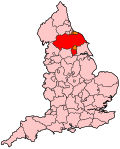
The Borough of Harrogate was a local government district with borough status in North Yorkshire, England, from 1974 to 2023. Its council was based in the town of Harrogate, but it also included surrounding settlements, including the cathedral city of Ripon, and almost all of the Nidderdale Area of Outstanding Natural Beauty. At the 2011 Census, the borough had a population of 157,869.

Harrogate was a constituency represented in the House of Commons of the UK Parliament. As with all constituencies, the constituency elected one Member of Parliament (MP) by the first past the post system of election. The constituency was renamed Harrogate and Knaresborough in 1997.

<span class="mw-page-title-main">Vale of York (UK Parliament constituency)</span> Parliamentary constituency in the United Kingdom, 1997–2010

Vale of York was a county constituency represented in the House of Commons of the Parliament of the United Kingdom. It elected one Member of Parliament (MP) by the first past the post system of election.

<span class="mw-page-title-main">Harrogate and Knaresborough (UK Parliament constituency)</span> Parliamentary constituency in the United Kingdom

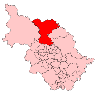
Harrogate and Knaresborough is a parliamentary constituency in North Yorkshire which has been represented in the House of Commons of the UK Parliament since 2010 by Andrew Jones, an MP from the Conservative Party. The constituency was formed in the 1997 boundary changes, before which it was named Harrogate.

<span class="mw-page-title-main">Pateley Bridge</span> Market town in North Yorkshire, England

Pateley Bridge is a market town in the civil parish of High and Low Bishopside, in Nidderdale, in the county and district of North Yorkshire, England. Historically part of the West Riding of Yorkshire, it lies on the River Nidd. It is in the Yorkshire Dales and just outside the Yorkshire Dales National Park.

<span class="mw-page-title-main">Nidderdale</span> Valley in Yorkshire, England

Nidderdale, historically also known as Netherdale, is one of the Yorkshire Dales in North Yorkshire, England. It is the upper valley of the River Nidd, which flows south underground and then along the dale, forming several reservoirs including the Gouthwaite Reservoir, before turning east and eventually joining the River Ouse.

<span class="mw-page-title-main">Nidderdale National Landscape</span> Area of Outstanding Natural Beauty in England

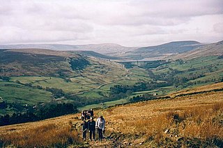
The Nidderdale National Landscape is an Area of Outstanding Natural Beauty in North Yorkshire, England, bordering the Yorkshire Dales National Park to the east and south. It comprises most of Nidderdale itself, part of lower Wharfedale, the Washburn valley and part of lower Wensleydale, including Jervaulx Abbey and the side valleys west of the River Ure. It covers a total area of 233 square miles (600 km2). The highest point in the Nidderdale AONB is Great Whernside, 704 metres (2,310 ft) above sea level, on the border with the Yorkshire Dales National Park.

<span class="mw-page-title-main">Bishop Monkton</span> Village and civil parish in North Yorkshire, England

Bishop Monkton is a village and civil parish in the former Harrogate district of North Yorkshire, England, about five miles south of Ripon. According to the 2001 census it had a population of 775, increasing slightly to 778 at the 2011 Census. In 2015, North Yorkshire County Council estimated the population to be 760.

<span class="mw-page-title-main">River Nidd</span> River in North Yorkshire, England

The River Nidd is a tributary of the River Ouse in the English county of North Yorkshire. In its first few miles it is dammed three times to create Angram Reservoir, Scar House Reservoir and Gouthwaite Reservoir, which attract a total of around 150,000 visitors a year. The Nidd can overflow the reservoirs, flooding the caves in the valley. In such cases the river overflows into the normally dry river bed past Lofthouse through to Gouthwaite Reservoir. The Yorkshire Dales Rivers Trust has a remit to conserve the ecological condition of the River Nidd from its headwaters to the Humber estuary.

<span class="mw-page-title-main">Ripon (UK Parliament constituency)</span> Parliamentary constituency in the United Kingdom, 1868–1983

Ripon was a constituency sending members to the House of Commons of England, Great Britain and the House of Commons of the Parliament of the United Kingdom until 1983, centred on the city of Ripon in North Yorkshire.

<span class="mw-page-title-main">Glasshouses, North Yorkshire</span> Village in North Yorkshire, England

Glasshouses is a small village in Nidderdale, North Yorkshire, England. It lies 1 mile (1.6 km) south-east of Pateley Bridge on the east side of Nidderdale and has a recently rebuilt river bridge across the River Nidd. In 2019 it had an estimated population of 536.

<span class="mw-page-title-main">Wath-in-Nidderdale</span> Village in North Yorkshire, England

Wath, sometimes known as Wath-in-Nidderdale to distinguish it from other places named Wath, is a village in the Harrogate district of North Yorkshire, England. It is near Gouthwaite Reservoir and about 3 miles (4.8 km) north of Pateley Bridge.

<span class="mw-page-title-main">Summerbridge, North Yorkshire</span> Hamlet in North Yorkshire, England

Summerbridge is a village in Nidderdale in North Yorkshire, England. It is on the River Nidd, adjacent to Dacre Banks on the opposite bank of the river, and lies about 2.5 miles (4 km) south east of Pateley Bridge. The village is part of the historic West Riding of Yorkshire.

<span class="mw-page-title-main">Burnt Yates</span> Village in North Yorkshire, England

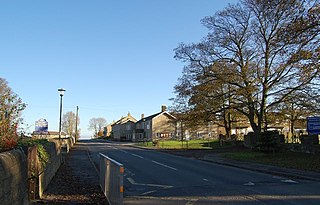
Burnt Yates is a village in the Borough of Harrogate in North Yorkshire, England.

<span class="mw-page-title-main">Nidd Valley Railway</span> Disused railway line in Yorkshire, England

The Nidd Valley Railway was a 11.5-mile (18.5 km) long single-track branch railway line that ran along the valley of the River Nidd in North Yorkshire, England. Built by the North Eastern Railway, it ran from Ripley Junction, on the Harrogate to Ripon Line, to Pateley Bridge via five intermediate stations, Ripley Valley, Hampsthwaite, Birstwith, Darley, and Dacre.

<span class="mw-page-title-main">Mickley, North Yorkshire</span> Village in North Yorkshire, England

Mickley is a village in the Harrogate District of North Yorkshire, England. The village is on the south bank of the River Ure between Masham and West Tanfield.

<span class="mw-page-title-main">High and Low Bishopside</span> Civil parish in North Yorkshire, England

High and Low Bishopside is a civil parish in Nidderdale in the Harrogate district, in the county of North Yorkshire, England. It includes the town of Pateley Bridge and the villages of Glasshouses and Wilsill, the southern part of Wath and the hamlets of Blazefield, and Fellbeck. The parish touches Bewerley, Dacre, Eavestone, Fountains Earth, Hartwith cum Winsley, Laverton, Sawley, Stonebeck Down and Warsill. In 2011 the parish had a population of 2,210. There are 39 listed buildings in High and Low Bishopside. The parish's council is called "Pateley Bridge Town Council".

Wetherby and Easingwold is a proposed constituency of the House of Commons in the UK Parliament, partly in North Yorkshire and partly in West Yorkshire. Further to the completion of the 2023 Periodic Review of Westminster constituencies, it will first be contested at the 2024 general election.

References

  1. "Constituency data: electorates – House of Commons Library". Parliament UK. 15 June 2020. Retrieved 22 July 2020.
  2. "'Skipton and Ripon', June 1983 up to May 1997". ElectionWeb Project. Cognitive Computing Limited. Retrieved 14 March 2016.[ permanent dead link ]
  3. Unemployment claimants by constituency The Guardian
  4. "The Parliamentary Constituencies Order 2023". Schedule 1 Part 9 Yorkshire and the Humber region.
  5. "The North Yorkshire (Structural Changes) Order 2022".
  6. "New Seat Details - Skipton and Ripon". www.electoralcalculus.co.uk. Retrieved 15 April 2024.
  7. Leigh Rayment's Historical List of MPs – Constituencies beginning with "S" (part 2)
  8. "Full list of all Green Party candidates at the next general election". Bright Green. 17 September 2023. Retrieved 22 March 2024.
  9. "Skipton and Ripon Constituency". Reform UK . Retrieved 22 March 2024.
  10. "Julian Smith re-selected for Tories in Skipton & Ripon". Rombalds Radio. Retrieved 22 March 2024.
  11. "Statement of persons nominated and notice of poll" (PDF). Craven District Council. 14 November 2019. Retrieved 15 November 2019.
  12. "Skipton & Ripon parliamentary constituency - Election 2017" via www.bbc.co.uk.
  13. "GENERAL ELECTION: Historic deal sees Lib/Dems stand down in Skipton and Ripon to make way for Greens". Craven Herald.
  14. "Election Data 2015". Electoral Calculus. Archived from the original on 17 October 2015. Retrieved 17 October 2015.
  15. "Skipton & Ripon". BBC News. Retrieved 13 May 2015.
  16. "Election Data 2010". Electoral Calculus. Archived from the original on 26 July 2013. Retrieved 17 October 2015.
  17. "UK > England > Yorkshire & the Humber > Skipton & Ripon". Election 2010. BBC. 7 May 2010. Retrieved 11 May 2010.
  18. "Election Data 2005". Electoral Calculus. Archived from the original on 15 October 2011. Retrieved 18 October 2015.
  19. "Election Data 2001". Electoral Calculus. Archived from the original on 15 October 2011. Retrieved 18 October 2015.
  20. "Election Data 1997". Electoral Calculus. Archived from the original on 15 October 2011. Retrieved 18 October 2015.
  21. "Election Data 1992". Electoral Calculus. Archived from the original on 15 October 2011. Retrieved 18 October 2015.
  22. "Politics Resources". Election 1992. Politics Resources. 9 April 1992. Retrieved 6 December 2010.
  23. "Election Data 1987". Electoral Calculus. Archived from the original on 15 October 2011. Retrieved 18 October 2015.
  24. "Election Data 1983". Electoral Calculus. Archived from the original on 15 October 2011. Retrieved 18 October 2015.

54°09′43″N1°49′59″W / 54.162°N 1.833°W / 54.162; -1.833