
Ende is the seat capital of the Ende Regency, East Nusa Tenggara province of Indonesia. Ende is located on the southern coast of Flores Island. The town had a population of 87,269 residents at the 2020 census, divided administratively between four districts (kecamatan) of the regency – Ende Selatan, Ende Timur, Ende Tengah, and Ende Utara. Note that this does not include Ende District. The official estimate as at mid 2023 was 88,921.

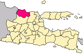
Lamongan Regency is a regency of the East Java Province of Indonesia. It has a total land area of approximately 1,812.8 km2 (699.9 sq mi) or + 3.78% of the area of East Java Province. With a length of 47 km (29 mi) along the coastline, the sea area of Lamongan Regency is about 902.4 km2 (348.4 sq mi), if calculated to a distance of 12 miles (19 km) across the ocean surface. At the 2010 census it had a population of 1,179,059; the 2020 Census produced a total of 1,379,628 and the official estimate as at mid-2023 was 1,385,835. The regency seat is the town of Lamongan, situated on the Solo River which passes from west to east through the regency, effectively dividing it in two.
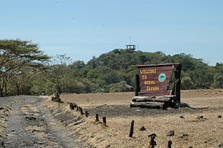
Situbondo Regency is a regency (kabupaten) in the east of East Java province, Indonesia. It covers an area of 1,658.03 km2, and had a population of 647,619 at the 2010 Census and 685,967 at the 2020 Census; the official estimate as at mid 2023 was 684,343. It is located towards the eastern end of Java, before Banyuwangi. The administrative centre is Situbondo, a small town within the regency. One of the famous tourist sites is Baluran National Park.

South Hulu Sungai Regency is one of the regencies (kabupaten) in South Kalimantan province, Indonesia. It had an area of 1,804.94 km2, and a population of 212,485 at the 2010 Census and 228,006 at the 2020 Census; the official estimate as at mid 2023 was 237.319. The capital of the regency is the town of Kandangan, which is famous for its culinary ketupat Kandangan.

South Bengkulu is a regency of Bengkulu Province, Indonesia, on the island of Sumatra. It originally comprised all of that part of Bengkulu Province situated to the southeast of the city of Bengkulu, but on 25 February 2003 this area was split into three parts, with the most southeastern districts split off to form a new Kaur Regency and the most northwestern districts split off to form a new Seluma Regency. The reduced South Bengkulu Regency now covers 1,186.10 km2, and had a population of 142,940 at the 2010 Census and 166,249 at the 2020 Census; the official estimate as at mid 2022 was 170,093. The regency's administrative centre is the coastal town of Manna.

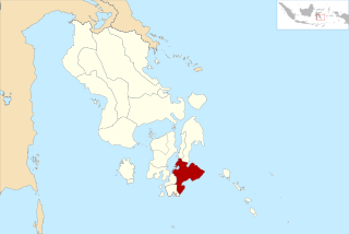
Mojokerto Regency is a regency in East Java Province of Indonesia. It is part of the Surabaya metropolitan area which comprises Gresik Regency, Bangkalan Regency, Mojokerto Regency, Mojokerto City, Surabaya City, Sidoarjo Regency, and Lamongan Regency. The Regency covers an area of 969.36 km2. The population of the Regency was 908,004 in 2000, but had risen to 1,025,443 at the 2010 Census and to 1,119,209 at the 2020 Census; the official estimate as of mid-2022 was 1,133,584, and the total for mid-2023 was 1,145,400. Many of them earn their living as small farmers and craftsmen.

Mandailing Natal, abbreviated as Madina, is a regency in North Sumatra Province of Indonesia. It covers an area of 6,620.70 square kilometres and it had a population of 403,894 people at the 2010 census and 472,886 at the 2020 Census; the official estimate as at mid 2023 was 496,975. The capital lies at Panyabungan. The Regency was formerly a part of South Tapanuli Regency until it was created as a separate regency on 23 November 1998. It is the southernmost regency in North Sumatra, and the largest regency by land area in the province, with Langkat Regency second to it.

Pinrang Regency is one of the twenty-one regencies in South Sulawesi Province of Indonesia. Pinrang town in Watang Sawitto District is the administrative capital of Pinrang Regency. The regency is situated in the northwest of the South Sulawesi peninsula, and covers a land area of 1,896.57 km2. It had a population of 351,161 at the 2010 Census and 403,994 at the 2020 Census; the official estimate as at mid 2023 was 417,932.

Sitaro Islands Regency is a regency located off the northern extremity of Sulawesi Island in the southern Sangihe Islands, North Sulawesi Province, Indonesia. The regency was formed under Law Number 15 Year 2007 from 2 January 2007, by separation from the Sangihe Islands Regency of which it had previously formed the southern part. The short form of the name is formed from one syllable from each of the names of the three principal islands — Siau, Tagulandang and Biaro.

Paser Regency is the southernmost regency (kabupaten) within the East Kalimantan province of Indonesia. It was created in 1959, originally spelt "Pasir Regency", but renamed "Paser" in 2007; however its northeastern districts were split off on 10 April 2002 to form the new Penajam North Paser Regency. The residual regency covers an area of 11,603.94 km2, and it had a population of 230,316 at the 2010 Census and 275,452 at the 2020 Census; the official estimate as at mid-2023 was 303,424. Its administrative centre is the town of Tana Paser.

Kapuas Regency is one of the thirteen regencies which divide Central Kalimantan Province, on the island of Kalimantan, Indonesia. It formerly covered a wider area, but on 10 April 2002 two further regencies were cut out of its western districts, and the residual area is now 17,070.39 km.2 Its population was 329,646 at the 2010 Census and 410,446 at the 2020 Census; the official estimate as at mid 2023 was 425,186. The administrative centre is the town of Kuala Kapuas near the coast, but the largest town is Selat, which includes 8 of the regency's 15 urban kelurahan, and had 72,382 inhabitants in mid 2023.
Buton Regency is a regency of Indonesia's Southeast Sulawesi Province, lying entirely on Buton Island. Until 2014 it had an area of 2,681.22 km2, and a population estimated at 276,944. However, in 2014 it was divided into three regencies, with two new regencies being cut out of it; the residual area now is 1,647.87 km2, and the districts in that area contained a population of 94,388 at the 2010 Census while the 2020 Census produced a total of 115,207; the official estimate as at mid 2023 was 120,873 The capital is nominally at Pasarwajo, but the regency's administration is actually undertaken in the city of Baubau on the south-west of the island, although that city is administratively separate from the Regency.

South Konawe Regency is a regency of Southeast Sulawesi Province, Indonesia. The regency was created on 25 February 2003 from what had been the southern districts of Konawe Regency. It covers an area of 4,237.74 km2 and had a population of 264,587 at the 2010 Census and of 308,524 at the 2020 Census; the official estimate as at mid 2023 was 322,946 - comprising 165,487 males and 157,459 females.< The administrative centre is in the town of Andoolo.

Minahasa Regency is a regency in North Sulawesi, Indonesia. Its capital is Tondano. It covers an area of 1,141.64 km2 and had a population of 310,384 at the 2010 Census; this rose to 347,290 at the 2020 Census, and the official estimate as at mid 2023 was 351,920.

North Minahasa Regency is a regency in North Sulawesi, Indonesia. Its capital is Airmadidi. It was originally part of the Minahasa Regency until it was split off and established as a separate regency on 20 November 2003. It covers an area of 1,059.24 km2, and had a population of 188,904 at the 2010 Census; this had risen to 224,993 at the 2020 Census, and the official estimate as at mid 2023 was 231,791. The Regency includes the offshore islands of Bangka and Talisei to the north of Sulawesi, and Mantenang and Naeng Besar to the northwest.

Southeast Minahasa Regency is a regency in North Sulawesi, Indonesia. It covers a land area of 730.63 km2, and had a population of 100,443 at the 2010 Census; this had risen to 116,323 at the 2020 Census, and the official estimate as at mid 2023 was 118,946. It was established as a separate regency from the south-eastern part of the South Minahasa Regency on 2 January 2007. Its administrative centre is at the town of Ratahan.
Tuban Regency is a regency in the East Java province of Indonesia. The Dutch name of the regency is 'Toeban'. It covers a land area of 1,839.94 sq. km, and had a population of 1,118,464 at the 2010 Census and 1,198,012 at the 2020 Census; the official estimate as of mid-2023 was 1,258,368. The administrative centre is the coastal town of Tuban.

Lumajang Regency is a Regency (kabupaten) located in the East Java province of Indonesia. It covers an area of 1,790.90 sq. km, and had a population of 1,006,458 at the 2010 Census and 1,119,251 at the 2020 Census. The mid 2022 official estimate was originally stated to be 1,137,230, but was revised down to 1,097,504. The official estimate for mid 2023 was 1,108,487. The regency shares its land borders with Jember Regency, Probolinggo Regency, and Malang Regency, while it borders the Indian Ocean to the south.

Penukal Abab Lematang Ilir Regency is a regency of South Sumatra Province, Indonesia. It takes its name from the three main rivers which flow through that area - the Penukal River, Abab River and Lematang River - while the name Ilir means "downstream". The town of Talang Ubi is the administrative centre of this regency. The regency borders Musi Banyuasin Regency to the north, Banyuasin Regency, and Muara Enim Regency to the east and the south, and by Musi Rawas Regency, and Muara Enim Regency to the west.
South Buton Regency is a regency located on Buton Island in Southeast Sulawesi Province of Indonesia. This regency was formed from the southern part of Buton Regency, from which it was separated by Act No.16 of 2014, dated 23 July 2014. It covers an area of 546.58 km2, and the population of the districts now comprising the new regency was 74,974 at the 2010 Census and 95,261 at the 2020 Census; the official estimate as at mid 2023 was 101,635. The regency capital is located in Batauga.


