
Sikka is a regency within East Nusa Tenggara province, Indonesia, on the island of Flores. It is bordered to the west by Ende Regency and to the east by East Flores Regency. It covers an area of 1,675.36 km2 and had a population of 300,301 at the 2010 census and 321,953 at the 2020 Census; the official estimate as at mid 2023 was 335,360 - comprising 163,060 males and 172,300 females). The capital is the town of Maumere, which comprises the districts of Alok Barat, Alok and Alok Timur.

Wonosobo Regency is a regency in Central Java province in Indonesia. The administrative centre of the regency is located in the town of Wonosobo, located at 7.3684940°S 109.8983841°E, about 120 km from Semarang on the Dieng Plateau. The regency's area is 984.68 km2 and its population was 754,883 at the 2010 census and 879,124 at the 2020 census; the official estimate as at mid 2023 was 909,664.

Barito Kuala Regency is one of the regencies (kabupaten) in the Indonesian province of South Kalimantan, situated in the southwest of the province. The area is 2,996.46 km2, and the population was 276,147 at the 2010 Census and 313,021 at the 2020 Census; the latest official estimate was 321,769. The capital is the town of Marabahan. The Motto of the Regency is "Selidah".

Pohuwato is a regency of Gorontalo Province, Indonesia. It is located on the northern peninsula of the island of Sulawesi. It was established on 25 February 2003 under Law Number 6/2003 by splitting off from the western part of Boalemo Regency. It has an area of 4,244.31 km2, and had a population of 128,748 at the 2010 Census and 146,432 at the 2020 Census; the official estimate as at mid 2023 was 160,187. The seat of the regency administration is in the town of Marisa.

Central Bangka Regency is a regency (kabupaten) of the Bangka Belitung Islands Province, Indonesia. It covers an area of 2,155.77 km2 and had a population of 161,075 at the 2010 Census, rising to 198,946 at the 2020 Census; the official estimate as at mid 2022 was 205,510 - comprising 106,340 males and 99,170 females. The town of Koba is its regency seat.

Pinrang Regency is one of the twenty-one regencies in South Sulawesi Province of Indonesia. Pinrang town in Watang Sawitto District is the administrative capital of Pinrang Regency. The regency is situated in the northwest of the South Sulawesi peninsula, and covers a land area of 1,896.57 km2. It had a population of 351,161 at the 2010 Census and 403,994 at the 2020 Census; the official estimate as at mid 2023 was 417,932.

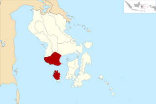
Dompu Regency is a regency of the Indonesian Province of West Nusa Tenggara. It is located on the island of Sumbawa and the capital is Dompu. It is bordered to the north and to the east by two non-contiguous parts of Bima Regency, and to the west by Sumbawa Regency, as well as on its coasts by Saleh Bay, Sanggar Bay, and Cempi Bay. It covers an area of 2,324.55 km2, and the population at the 2010 Census was 218,984 and at the 2020 Census was 236,665; the official estimate as at mid 2023 was 247,188.

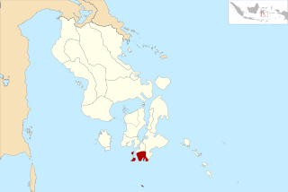
East Flores Regency is a regency in East Nusa Tenggara province of Indonesia. Established in 1958, the regency has its seat (capital) in Larantuka on Flores Island. It covers a land area of 1,812.58 km2, and it had a population of 232,605 as of the 2010 census and 276,896 at the 2020 Census; the official estimate as of mid-2023 was 288,310 - comprising 141,738 males and 146,572 females. The regency encompasses the eastern tip of the island of Flores, together with all of the adjacent islands of Adonara and Solor to the east of Flores, with some much smaller offshore islands. On 4 October 1999, the island of Lembata at the eastern end of the Solor Archipelago was separated from the East Flores Regency to create its own Regency.

Sitaro Islands Regency is a regency located off the northern extremity of Sulawesi Island in the southern Sangihe Islands, North Sulawesi Province, Indonesia. The regency was formed under Law Number 15 Year 2007 from 2 January 2007, by separation from the Sangihe Islands Regency of which it had previously formed the southern part. The short form of the name is formed from one syllable from each of the names of the three principal islands — Siau, Tagulandang and Biaro.

Paser Regency is a regency (kabupaten) within East Kalimantan province in Indonesia, it is the southernmost regency of the East Kalimantan province. Its administrative centre is Tana Paser. It covers an area of 7,730 km2, and it had a population of 230,316 at the 2010 Census and 275,452 at the 2020 Census; the official estimate as at mid-2022 was 280,065 . Before 2007, this regency was formerly named Pasir Regency.
Bombana Regency is a regency of Southeast Sulawesi Province of Indonesia. It consists of part of the southeast peninsula of Sulawesi, together with most of the substantial offshore island of Kabaena to the south. The regency was created on 18 December 2003 from part of Buton Regency. It covers an area of 3,293.97 km2, and had a population on 139,235 at the 2010 Census and 150,706 at the 2020 Census; the official estimate as at mid 2023 was 163,402 - comprising 82,602 males and 80,800 females. The administrative centre lies at the town of Rumbia.
North Buton Regency is a regency of Indonesia's Southeast Sulawesi Province, which was separated from Buton Regency in accordance with Indonesia's Law Number 14 of 2007. The area of the regency, which covers the north part of Buton Island, is 1,923.03 km2. Its population was 54,736 at the 2010 Census and 66,653 at the 2020 Census; the official estimate as at mid 2023 was 72,757. The administrative capital of the regency is at the town of Buranga, in Bonegunu District.

North Kolaka Regency is a regency in the northwest part of Southeast Sulawesi province of Indonesia. It was created on 18 December 2003 from the former northern districts of Kolaka Regency. It covers an area of 2,932 km2, and had a population of 121,476 at the 2010 Census, and 137,700 at the 2020 Census; the official estimate as at mid 2023 was 140,488 - comprising 71,995 males and 68,493 females. The principal town lies at Lasusua.
Tolitoli Regency is a regency of Central Sulawesi Province of Indonesia. It was previously part of a larger Buol Tolitoli Regency, but this was split into two on 4 October 1999 after rapid decentralization of the Indonesian government. The present Tolitoli Regency covers an area of 3,701.54 km2 and had a population of 211,296 at the 2010 Census and 225,154 at the 2020 Census; the official estimate as at mid 2023 was 231,711, comprising 118,180 male and 113,530 female inhabitants. Its regency seat is located at the town of Tolitoli, which is a port town and where the regency's population is concentrated.

Minahasa Regency is a regency in North Sulawesi, Indonesia. Its capital is Tondano. It covers an area of 1,141.64 km2 and had a population of 310,384 at the 2010 Census; this rose to 347,290 at the 2020 Census, and the official estimate as at mid 2023 was 351,920.

North Minahasa Regency is a regency in North Sulawesi, Indonesia. Its capital is Airmadidi. It was originally part of the Minahasa Regency until it was split off and established as a separate regency on 20 November 2003. It covers an area of 1,059.24 km2, and had a population of 188,904 at the 2010 Census; this had risen to 224,993 at the 2020 Census, and the official estimate as at mid 2023 was 231,791. The Regency includes the offshore islands of Bangka and Talisei to the north of Sulawesi, and Mantenang and Naeng Besar to the northwest.

South Minahasa Regency is a regency in North Sulawesi, Indonesia. Its capital is the town of Amurang. It was originally part of the Minahasa Regency until it was established as a separate regency on 25 February 2003. In turn, nearly four years later, a new Southeast Minahasa Regency was established as a separate regency from part of the South Minahasa Regency on 2 January 2007. The residual Regency now covers an area of 1,456.74 km2, and had a population of 195,553 at the 2010 Census; this had risen to 236,463 at the 2020 Census; the official estimate as at mid 2023 was 244,590.
West Muna Regency is a new regency of Southeast Sulawesi Province of Indonesia,and is situated in the northwest corner of Muna Island and smaller ilsands of its coast. It was established under Act No.14 of 2014, dated 23 July 2014 by separation from the Muna Regency. It covers an area of 906.28 km2, and the districts comprising it had a population of 71,632 at the 2010 Census; the 2020 Census resulted in a population of 84,590, and the official estimate as at mid 2022 was 85,706, comprising 42,242 males and 43,464 females. The administrative centre lies at Laworo in the Tiworo Islands District.

Central Buton Regency is a new regency of Southeast Sulawesi established by separation from Buton Regency under Act No.15 of 2014, dated 23 July 2014. It covers an area of 837.16 km2 comprising the southern parts of Muna Island and Kabaena Island, together with several small offshore islands adjacent to these two main islands, but with no territory located on Buton Island. It had a population of 86,112 at the 2010 Census and 114,773 at the 2020 Census; the official estimate as at mid 2023 was 121,369. The administrative centre lies at Labungkari in Lakudo District.
South Buton Regency is a regency located on Buton Island in Southeast Sulawesi Province of Indonesia. This regency was formed from the southern part of Buton Regency, from which it was separated by Act No.16 of 2014, dated 23 July 2014. It covers an area of 546.58 km2, and the population of the districts now comprising the new regency was 74,974 at the 2010 Census and 95,261 at the 2020 Census; the official estimate as at mid 2023 was 101,635. The regency capital is located in Batauga.


