Special routes of U.S. Route 71

Last updated

US 71.svg


Special routes of U.S. Route 71
Highway system

A total of ten special routes of U.S. Route 71 exist, and another ten previously existed.

Contents

Alexandria bypass

By-pass plate.svg

US 71.svg

U.S. Highway 71 Bypass

Location Alexandria, Louisiana

Bypass US 71 is a controlled access highway at Alexandria, Louisiana. Its northern terminus is an interchange with Interstate 49 and US 71 and US 165 north of Alexandria. Its southern terminus is at an interchange with I-49 and US 71/US 167 south of Alexandria. Bypass 71 runs a total distance of approximately six miles (9.7 km) and runs concurrently with I-49 its whole length. It is signed at both the north and south termini as By-Pass US 71.

Waldron business route

US 71B.svg

U.S. Highway 71B

Location Waldron, Arkansas
Length6.32 mi [1]  (10.17 km)
US 71B in Waldron Waldron, AR 001.jpg
US 71B in Waldron

Business US 71 in Waldron runs approximately seven miles (11 km) beginning at US 71 2 +1/2[ convert: unknown unit ] north of Waldron and ending at US 71 4+12 miles (7.2 km) south of Waldron. Signed locally as Main Street, it was created in 1971 after US 71 was rerouted around the west side of town.

Fort Smith business loop

US 71B.svg

U.S. Highway 71B

Location Fort Smith, Arkansas
Length13.2 mi [2]  (21.2 km)

US 71 Business runs approximately 13 miles (21 km) between Alma and Fort Smith, Arkansas. Its northern terminus is at I-40 and US 71 at Alma and its southern terminus is at I-540 and US 71 in south Fort Smith. US 71 Bus. passes through the towns of Alma, Van Buren and Fort Smith. One half mile south of I-40 at Alma, US 71 Bus. intersects US 64 and overlaps it to downtown Fort Smith and the junction of Arkansas Highway 22.

Within the city of Fort Smith, US 71 Bus. is commonly referred to by the names of Midland Boulevard (north of downtown), North 10th (one-way north-to-south) and North 11th Streets (one-way south-to-north) within downtown, Towson Avenue (south of downtown) and Zero Street (beginning at the intersection of US 271 and AR 255).

Northwest Arkansas business route

US 71B.svg

U.S. Highway 71B

Location Northwest Arkansas
Length21.376 mi [3] [4]  (34.401 km)
ExistedMay 27, 1970 [5] –present

U.S. Route 71 Business (US 71B) in Northwest Arkansas is a business route of US 71 that spans 21.376 miles (34.401 km). [3] [4]

US 71B begins at AR 112 (Garland Avenue) in Fayetteville, the southernmost principal city of the Northwest Arkansas region. The runs east as the J. William Fulbright Expressway with access to I-49 (as well as unsigned US 71 and US 62). US 71B passes the Washington Regional Medical Center on its way through uptown Fayetteville as a controlled-access highway, with exits signed for Gregg Avenue and College Avenue. The expressway ends and Highway 71B becomes College Avenue heading north, a four-lane divided highway. A junction with Joyce Boulevard is signed for access to I-49/US 62/US 62 via a jughandle intersection. Continuing north, US 71B passes the Northwest Arkansas Mall and Lake Fayetteville prior to entering Springdale. [6]

US 71B joins US 412 northbound at Robinson Avenue in Springdale. US Route 71B intersects US 412, Springdale, AR.jpg
US 71B joins US 412 northbound at Robinson Avenue in Springdale.

Now known as Thompson Street, US 71B is a principal arterial in Springdale; passing the Springdale Country Club, intersecting Don Tyson Parkway, and crossing under the Arkansas and Missouri Railroad tracks before a junction with US 412 (Robinson Avenue). A concurrency begins northward, with US 412/US 71B keeping the Thompson Avenue designation. After a short distance, US 412 turns west onto Sunset Avenue, with US 71B continuing north as Thompson Street into a commercial area of Springdale. The road passes Murphy Park, Springdale High School, and junctions with Emma Avenue just west of the Springdale Poultry Industry Historic District. North of the junction with Emma Avenue, US 71B passes the Springdale Public Schools Administrative Offices and passes over the Northwest Arkansas Razorback Regional Greenway and Spring Creek before entering Benton County. [7]

US 71B passes the Beasley Homestead (listed on the National Register of Historic Places) shortly before serving as the western terminus of a segment of Highway 264.

US 71B becomes Bloomington Street in Lowell as it continues north to AR 94 (New Hope Road). Entering Rogers, US 71B meets US 62/AR 12 and becomes Walnut Street and turns east. The route passes St. Mary's Hospital and Dixieland Mall and crosses to I-49 as it enters Bentonville.

History
US 71B was created by the Arkansas State Highway Commission on May 27, 1970. The designation followed the historic alignment of US 71 through Fayetteville, with the mainline US 71 designation moved to the bypass, [5] which would become I-540 in 2000 and I-49 in 2014.

The highway was truncated in Bentonville from the former northern terminus (I-49, US 71 and AR 549) to an intersection of SW Regional Airport Boulevard and Walton Boulevard (colloquially known as Rainbow Curve) in 2018. [8] In late 2019, most of the alignment in Fayetteville was transferred to city maintenance. The agreement allowed Fayetteville to construct a redesign without seeking ARDOT approval for the changes. [9] [10]

Major intersections

CountyLocationmi [1] [3] [4] kmDestinationsNotes
Washington Fayetteville 0.0000.000Arkansas 112.svg AR 112 (Garland Avenue) Fayetteville, University of Arkansas, Tontitown, Cave Springs Southern terminus
0.50.80I-49.svgUS 71 (AR).svg I-49  / US 62  / US 71  Fort Smith, Joplin, MO
1.32.1Gregg AvenueAccess to Gregg Avenue via Futrall Drive (northbound) and Shiloh Drive (southbound)
1.652.66College Avenue southExpressway ends, roadway becomes College Avenue heading north
Joyce Boulevard To plate blue.svg
I-49.svg
To plate.svg
US 71 (AR).svg
To plate.svg
US 62 (AR).svg
To I-49  / US 71  / US 62 (Fulbright Expressway)
Northbound has jughandle entrance to Fulbright Expressway
Springdale To plate.svg
East plate.svg
US 412 (AR).svg
Airport Sign.svg To US 412 east (Robinson Avenue) Huntsville
US Highway 412Y
East plate.svg
US 412 (AR).svg
Airport Sign.svg US 412 east (Thompson Street) Huntsville
Southern end of US 412 concurrency
10.8017.38West plate.svg
US 412 (AR).svg
US 412 west (Sunset Avenue) Siloam Springs
Northern end of US 412 concurrency
Benton 14.3023.01East plate.svg
Arkansas 264.svg
AR 264 east
AR 264 western terminus
Arkansas 612.svg AR 612 (Springdale Northern Bypass)
Lowell 16.2926.22West plate.svg
Arkansas 264.svg
To plate blue.svg
I-49.svg
AR 264 west (Monroe Avenue) to I-49  Cave Springs
AR 264 eastern terminus
Rogers East plate.svg
Arkansas 94.svg
AR 94 east (New Hope Road) Monte Ne
Southern end of AR 94 concurrency
Olrich Street eastFormer AR 102
Poplar Street eastFormer AR 12 and AR 94
West plate.svg
Arkansas 94.svg
To plate.svg
US 62 (AR).svg
To plate.svg
Arkansas 12.svg
AR 94 west (8th Street) to US 62  / AR 12
Northern end of AR 94 concurrency
RogersBentonville line19.89532.018I-49.svg I-49  / US 71  / US 62  Springdale, Fayetteville
Bentonville 21.37634.401End state manintenance, roadway continues as Walton BoulevardNorthern terminus
1.000 mi = 1.609 km; 1.000 km = 0.621 mi

Pineville–Anderson business loop

Business plate.svg

US 71.svg

U.S. Route 71 Business

Location PinevilleAnderson, Missouri
Length12.7 mi [11]  (20.4 km)
Existed2005–present

Business Loop 71 is an alternate alignment of U.S. Route 71 in southwest Missouri. Its northern terminus is at a partial interchange with I-49/US 71 approximately 7 miles (11 km) north of Anderson. Its southern terminus is an at-grade intersection with US 71 and Wolf Den Road (also known as McDonald County Road 71-22B SW) approximately 2 miles (3.2 km) south of Pineville. In Anderson, Business 71 runs concurrently with Route 59 for approximately 6 miles (9.7 km) and Route 76 for 2 miles (3.2 km). Business 71 was originally created in 2005 running from 7 miles (11 km) north of Anderson to 2 miles (3.2 km) south of town at an at-grade intersection with US 71. In 2007, it was extended along the former US 71 in Pineville after a new freeway section was built bypassing the town.

Savannah business loop

Business plate.svg

US 71.svg

U.S. Route 71 Business

Location Savannah, Missouri
Length8.8 mi [12]  (14.2 km)

Maryville business loop

Business plate.svg

US 71.svg

U.S. Route 71 Business

Location Maryville, Missouri
Length5.1 mi [13]  (8.2 km)

Business 71 is a former alignment of US 71 through Maryville, Missouri. Running a distance of approximately 5 miles (8.0 km), its southern terminus is at US 71 south of Maryville. Its northern terminus is an intersection with US 71 and US 136 north of Maryville.

Clarinda business loop

Business plate.svg

US 71 (1961).svg

U.S. Highway 71 Business

Location Clarinda, Iowa
Length2.6 mi [14]  (4.2 km)

U.S. Route 71 Business is a former alignment of US 71 through Clarinda, Iowa. It begins at the junction of U.S. Route 71 and Iowa Highway 2 in southern Clarinda. Then, it follows 16th Street (Glenn Miller Avenue) towards downtown Clarinda. At Washington Street, US 71 Business meets Iowa 2 Business, and both routes continue east, eventually leaving Clarinda. East of Clarinda, US 71 Bus./IA 2 Bus. intersect US 71. US 71 Business ends while Iowa 2 Business continues south to complete its business loop. The entire route is in Clarinda, Page County.

mikmDestinationsNotes
US 71.svgCircle sign 2.svg US 71  / Iowa 2
West plate.svg
Business plate.svg
Circle sign 2.svg
Iowa 2 Business west
Southern end of IA 2 Bus. overlap
US 71.svgEast plate.svg
Business plate.svg
Circle sign 2.svg
US 71  / Iowa 2 Business east
Northern end of IA 2 Bus. overlap
1.000 mi = 1.609 km; 1.000 km = 0.621 mi

Storm Lake business loop

Business plate.svg

US 71 (1961).svg

U.S. Highway 71 Business

Location Storm Lake, Iowa
Length10.6 mi [15]  (17.1 km)

U.S. Route 71 Business is a former alignment of US 71 in Storm Lake, Iowa. It begins at the junction of U.S. Route 71 and Iowa Highway 7. It follows Iowa 7 into Storm Lake along Lakeshore Drive, Flindt Drive, and Milwaukee Avenue. At Lake Avenue, US 71 Business turns north, leaving Iowa 7, where it eventually leaves Storm Lake. Near Truesdale, US 71 Bus. turns east and rejoins US 71. The entire route is in Buena Vista County.

LocationmikmDestinationsNotes
Storm Lake US 71.svgWest plate.svg
Circle sign 7.svg
US 71  / Iowa 7 west
Southern end of IA 7 overlap
West plate.svg
Circle sign 7.svg
Iowa 7 west (Milwaukee Avenue)
Northern end of IA 7 overlap
Truesdale US 71.svg US 71
1.000 mi = 1.609 km; 1.000 km = 0.621 mi

Willmar business loop

Business plate.svg

US 71.svg

U.S. Highway 71 Business

Location Willmar, Minnesota
Length5.5 mi [16]  (8.9 km)

MN-23 Business.svg

Trunk Highway 23 Business

Location Willmar, Minnesota
Length5.5 mi [17]  (8.9 km)

U.S. Highway 71 Business (US 71 Bus.), which is completely concurrent with State Highway 23 Business (MN 23 Bus.) is a city-maintained business loop through the city of Willmar, Minnesota.

The entire route is in Willmar, Kandiyohi County.

mikmDestinationsNotes
South plate.svg
US 71.svg
West plate blue.svg
MN-23.svg
US 71 south / MN 23 west Olivia, Granite Falls
Southern/western terminus
To plate.svg
US 12.svg
To US 12 (Litchfield Avenue) Downtown
West plate.svg
County 24 square.svg
CSAH 24 west (26th Avenue NE)
23rd Street NE east
Former MN 294; Also access to Ridgewater College, Kandiyohi County Health & Human Services Building
North plate.svg
US 71.svg
East plate blue.svg
MN-23.svg
US 71 north / MN 23 east
Access to northbound US 71/eastbound MN 23 only
1.000 mi = 1.609 km; 1.000 km = 0.621 mi

Former routes

I-49 business routes

On December 12, 2012, a portion of US 71 in Missouri was designated as Interstate 49. Four US 71 business routes that connected to the affected section of US 71 were redesignated as I-49 business routes:

Alexandria business loop

Business plate.svg

US 71.svg

U.S. Highway 71 Business

Location Alexandria, Louisiana
Existed1945–1975

Business 71 is a former alignment of US 71 in Alexandria. It followed the original routing of US 71 before the construction of Alexandria's current highway system. It began at an intersection with Lee Street and MacArthur Drive, and followed Lee Street. It turned west at an intersection with LA 1, following Bolton Avenue to US 165. It was deleted in the mid-1970s.

Joplin business loop

Business plate.svg

US 71.svg

U.S. Route 71 Business

Location Joplin, Missouri
Existedby 1945–ca. 1979

US 71 Bus. followed 32nd Street (Route FF), Main Street (Route 43), Broadway Street, St. Louis Avenue, Euclid Avenue, Utica Street, Florida Avenue, and Zora Street through downtown Joplin. From Main Street to Zora Street was originally the 1926 alignment of U.S Route 66. The part of US 71 that it looped off of is now I-49 Bus. The Joplin business loop was the first such route in Missouri; all others at the time were "city" routes. [18]

Joplin alternate

Alternate plate.svg

US 71.svg

U.S. Route 71 Alternate

Location Joplin, Missouri
Former Alternate US 71 near Carthage, Missouri. This section is now a frontage road ("outer road" in Missouri) of US 71. ALT US 71.JPG
Former Alternate US 71 near Carthage, Missouri. This section is now a frontage road ("outer road" in Missouri) of US 71.

Alternate US 71 was a former special route which provided an alternate route for US 71 between Carthage and Neosho, Missouri, bypassing Joplin. Both endpoints were junctions with US 71. This section of road from Fidelity to Carthage was originally Route 38, renumbered Route 38N in about 1930.

At Carthage, Alternate US 71 followed what is currently Route 571 to US 71 at what is now the intersection of Route 96/Route 571. When the freeway was built around Carthage, it ended at that the current exit of 71 at Route 96/571 and Business US 71.

In 1999, the Alternate 71 designation was deleted. The section north of Interstate 44 at Fidelity was redesignated US 71, with the former US 71 being designated Business 71. South of Interstate 44, it continues as Route 59 to U.S. Route 60. From there it followed US 60 to Neosho. Other than its endpoints, only two towns were located on the former highway: Fidelity, Missouri and Diamond, Missouri.

The road was originally assigned at Optional US 71 in 1932 and changed to Alternate US 71 in 1935.

Kansas City bypass

By-pass plate.svg

US 71.svg

U.S. Route 71 Bypass

Location Kansas City, Missouri
Length59.0 mi [19]  (95.0 km)
Existed1932–1969

U.S. Route 71 Bypass was the original name for a highway that connected Harrisonville, Missouri, to just south of Platte City, where it rejoined US 71 near Kansas City International Airport. When I-29 was opened in the mid-1960s, it was renumbered Route 291.

At Lee's Summit, Missouri, it connects to I-470. It remains concurrent with the Interstate, until I-470 terminates at I-70. Route 291 continues to the north after its junction with I-70. The route has been rerouted several times, and has seen improvements over the years, and continues to be a major highway in eastern Jackson County, Missouri. In Platte and Clay Counties, it also is known as Cookingham Drive, and Mid Continent Trafficway.

St. Joseph business loop

Business plate.svg

US 71.svg

U.S. Route 71 Business

Location St. Joseph, Missouri

Platte City bypass

By-pass plate.svg

US 71.svg

U.S. Route 71 Bypass

Location Platte City, Missouri

Related Research Articles

<span class="mw-page-title-main">Interstate 49</span> Interstate Highway in Louisiana, Arkansas, and Missouri

Interstate 49 (I-49) is a north–south Interstate Highway that exists in multiple segments: the original portion entirely within the state of Louisiana with an additional signed portion extending from I-220 in Shreveport to the Arkansas state line, three newer sections in Arkansas, and a new section that opened in Missouri. Its southern terminus is in Lafayette, Louisiana, at I-10 while its northern terminus is in Kansas City, Missouri, at I-435 and I-470. Portions of the remaining roadway in Louisiana, Arkansas, and Texas, which will link Kansas City with New Orleans, are in various stages of planning or construction.

<span class="mw-page-title-main">U.S. Route 412</span> Highway in the United States

U.S. Route 412 is an east–west United States highway, first commissioned in 1982. U.S. 412 overlaps expressway-grade Cimarron Turnpike from Tulsa west to Interstate 35 and the Cherokee Turnpike from 5 miles (8.0 km) east of Chouteau, Oklahoma, to 8 miles (13 km) west of the Arkansas state line. It runs the entire length of the Oklahoma Panhandle and traverses the Missouri Bootheel.

<span class="mw-page-title-main">U.S. Route 71</span> US highway that goes from Ontario, Canada to Louisiana, United States

U.S. Route 71 or U.S. Highway 71 is a major north–south United States highway that extends for over 1500 miles (2500 km) in the central United States. This original 1926 route has remained largely unchanged by encroaching Interstate highways. Currently, the highway's northern terminus is in International Falls, Minnesota at the Canada–US border, at the southern end of the Fort Frances-International Falls International Bridge to Fort Frances, Ontario. U.S. Route 53 also ends here. On the other side of the bridge, Trans-Canada Highway is an east–west route while Highway 71 is a north–south route. US 71's southern terminus is between Port Barre and Krotz Springs, Louisiana at an intersection with U.S. Route 190. For the entirety south of Kansas City, Missouri, US 71 runs parallel and concurrent with the existing and future Interstate 49. North of Kansas City, US 71 runs halfway between Interstate 29 and Interstate 35, which they split in the city at an interchange with Interstate 70.

<span class="mw-page-title-main">U.S. Route 167</span> Highway in the United States

U.S. Route 167 runs for 500 miles (800 km) from Ash Flat, Arkansas at U.S. Route 62/US Route 412 to Abbeville, Louisiana at Louisiana Highway 14. It goes through the cities of Little Rock, Arkansas, Alexandria, Louisiana, and Lafayette, Louisiana.

<span class="mw-page-title-main">Missouri Route 13</span> State highway in Missouri

Route 13 is a highway in Missouri which runs almost the entire north–south length of the state. Its northern terminus is at U.S. Route 69/136 in Bethany. Its southern terminus is at the Arkansas state line in downtown Blue Eye, Missouri–Arkansas where it continues as Highway 21. It is one of the original state highways of Missouri.

<span class="mw-page-title-main">Arkansas Highway 16</span>

Highway 16 is an east–west state highway in Arkansas. The route begins in Siloam Springs at US Highway 412 (US 412) and Highway 59 and runs east through Fayetteville and the Ozark National Forest to US Highway 67 Business (US 67B) in Searcy. Highway 16 was created during the 1926 Arkansas state highway numbering, and today serves as a narrow, winding, 2-lane road except for overlaps of 10 miles (16 km) through Fayetteville. Much of the highway winds through the Ozarks, including the Ozark National Forest, where a portion of the highway is designated as an Arkansas Scenic Byway. The route has two spur routes in Northwest Arkansas; in Fayetteville and Siloam Springs.

<span class="mw-page-title-main">Arkansas Highway 102</span>

Highway 102 is an east–west state highway in Benton County, Arkansas. The highway connects two of western Benton County's population centers to Bentonville and Interstate 49 (I-49), the main north-south route in the Northwest Arkansas region.

<span class="mw-page-title-main">Arkansas Highway 180</span>

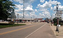
Highway 180 is a state highway of 1.723 miles (2.773 km) in Fayetteville. The route begins at Interstate 49/US 62/US 71/Highway 16 and runs east through Fayetteville to School Avenue. Highway 180 is designated as part of the Trail of Tears National Historic Trail as well as Arkansas Heritage Trails System designations as the Butterfield Trail, Trail of Tears, and Civil War Trails.

<span class="mw-page-title-main">Arkansas Highway 265</span>

Highway 265 is a designation for three state highways in Northwest Arkansas. The southern segment of 19.70 miles (31.70 km) runs from Highway 170 near Strickler north to I-49/US 71/Highway 112 in south Fayetteville. A second segment begins in east Fayetteville at Highway 16 and runs north through Springdale to Highway 94 in Rogers. Further north, a third segment of 3.324 miles (5.349 km) runs from Highway 94 in Pea Ridge north to the Missouri state line. The highways are maintained by the Arkansas Department of Transportation (ARDOT).

<span class="mw-page-title-main">Special routes of U.S. Route 60</span>

U.S. Route 60 has 25 current special routes. Of these, 20 are business routes, two alternate routes, one bypass route, and one truck route. US 60 has also had one additional business route, an additional bypass route, a temporary route, and another truck route.

<span class="mw-page-title-main">Special routes of U.S. Route 62</span>

Sixteen special routes of U.S. Route 62 currently exist. Seven of them lie within the state of Arkansas. Three existed in the past but have since been decommissioned.

<span class="mw-page-title-main">Special routes of U.S. Route 67</span>

Numerous special routes of U.S. Route 67, all business routes, exist. One other route, formerly an alternate route in western Illinois, has since been downgraded to state Route 267.

<span class="mw-page-title-main">Special routes of U.S. Route 65</span>

A total of eight special routes of U.S. Route 65 exist, divided between the U.S. states of Arkansas and Missouri. Currently, they are all business loops, although a spur route in Pine Bluff, Arkansas and bypass routes in Baton Rouge, Louisiana and Springfield, Missouri both existed in the past.

<span class="mw-page-title-main">Special routes of U.S. Route 412</span>

Six special routes of U.S. Route 412 exist.

<span class="mw-page-title-main">Special routes of U.S. Route 70</span>

Several special routes of U.S. Route 70 exist. In order from west to east, these special routes are as follows.

<span class="mw-page-title-main">Special routes of U.S. Route 63</span>

Twelve special routes of U.S. Route 63 currently exist. Arkansas and Missouri each contain five, with two in Iowa. There are also five former routings that have been removed from the system.

<span class="mw-page-title-main">Special routes of U.S. Route 15</span>

Several special routes of U.S. Route 15 exist. In order from south to north they are as follows.

<span class="mw-page-title-main">Special routes of U.S. Route 25</span> Routes in Georgia

Several special routes of U.S. Route 25 exist. In order from south to north they are as follows.

<span class="mw-page-title-main">U.S. Route 71 in Arkansas</span>

U.S. Highway 71 is a U.S. highway that runs from Krotz Springs, LA to the Fort Frances–International Falls International Bridge at the Canadian border. In Arkansas, the highway runs from the Louisiana state line near Doddridge to the Missouri state line near Bella Vista. In Texarkana, the highway runs along State Line Avenue with US 59 and partially runs in Texas. Other areas served by the highway include Fort Smith and Northwest Arkansas.

<span class="mw-page-title-main">Business routes of Interstate 40</span> Highway system

Interstate business routes are roads connecting a central or commercial district of a city or town with an Interstate bypass. These roads typically follow along local streets often along a former U.S. Route or state highway that had been replaced by an Interstate. Interstate business route reassurance markers are signed as either loops or spurs using a green shield shaped and numbered like the shield of the parent Interstate highway.

References

  1. 1 2 "[Arkansas] State Highways 2009 (Database)." April 2010. AHTD: Planning and Research Division. Mileage includes flyover of 1.83 miles (2.95 km) serving I-540/US 71/US 62 Database. Archived July 7, 2011, at the Wayback Machine Retrieved June 5, 2011.
  2. Google (December 19, 2022). "Overview map of US 71 Business (Fort Smith, AR)" (Map). Google Maps . Google. Retrieved December 19, 2022.
  3. 1 2 3 Transportation Planning and Policy Division (November 6, 2020). State Highway Route and Section Map, Washington County (PDF) (Map). Cartography by Geographic Information Systems & Mapping Section. Little Rock: Arkansas Department of Transportation. Retrieved December 27, 2020.{{cite map}}: |author= has generic name (help)
  4. 1 2 3 Transportation Planning and Policy Division (August 27, 2020). State Highway Route and Section Map, Benton County (PDF) (Map). Cartography by Geographic Information Systems & Mapping Section. Little Rock: Arkansas Department of Transportation. Retrieved December 27, 2020.{{cite map}}: |author= has generic name (help)
  5. 1 2 "Minutes of the Meeting" (PDF). Arkansas State Highway Commission. May 27, 1970. p. 1624. Retrieved January 28, 2013.
  6. Transportation Planning and Policy Division (August 2020). Map of Farmington, Fayetteville, Greenland and Johnson, Washington County, Arkansas (PDF) (Map). 1:12,000. Cartography by Geographic Information Systems & Mapping Section. Little Rock: Arkansas Department of Transportation. § A11, B11, C11, D9-11. Retrieved January 2, 2021.{{cite map}}: |author= has generic name (help)
  7. Transportation Planning and Policy Division (January 17, 2019) [October 21, 2010]. General Highway Map, Washington County, Arkansas (PDF) (Map) (Revised ed.). 1:62,500. Little Rock: Arkansas State Highway and Transportation Department. OCLC   919734758 . Retrieved January 2, 2021.{{cite map}}: |author= has generic name (help)
  8. Gute, Melissa (October 29, 2018). "Walton Boulevard to become Bentonville's responsibility". Arkansas Democrat-Gazette . Little Rock: WEHCO Media. ISSN   1060-4332 . Retrieved December 27, 2020.
  9. Ryburn, Stacy (September 2, 2019). "Fayetteville, ArDOT reach agreement on future of U.S. 71B". Arkansas Democrat-Gazette. Little Rock: WEHCO Media. ISSN   1060-4332 . Retrieved December 27, 2020.
  10. O'Neill, Kelly (December 18, 2019). "Fayetteville City Council moves forward with 71B corridor plan". KNWA . Retrieved December 27, 2020.
  11. Google (February 1, 2023). "Overview map of US 71 Business (Pineville–Anderson, MO)" (Map). Google Maps . Google. Retrieved February 1, 2023.
  12. Google (January 8, 2023). "Overview map of US 71 Business (Savannah, MO)" (Map). Google Maps . Google. Retrieved January 8, 2023.
  13. Google (December 19, 2022). "Overview map of US 71 Business" (Map). Google Maps . Google. Retrieved December 19, 2022.
  14. Google (February 28, 2023). "Overview map of US 71 Business (Clarinda, IA)" (Map). Google Maps . Google. Retrieved February 28, 2023.
  15. Google (February 28, 2023). "Overview map of US 71 Business (Storm Lake, IA)" (Map). Google Maps . Google. Retrieved February 28, 2023.
  16. Google (December 19, 2022). "Overview map of US 71 Business" (Map). Google Maps . Google. Retrieved December 19, 2022.
  17. Google (December 19, 2022). "Overview map Minnesota Route 23 Business" (Map). Google Maps . Google. Retrieved December 19, 2022.
  18. Missouri Highway Map Archive (1945-46 front, 1979 back, 1980 back)
  19. Google (February 28, 2023). "Overview map of US 71 Bypass (Kansas City, MO)" (Map). Google Maps . Google. Retrieved February 28, 2023.