Stockton, Illinois

Last updated

Stockton
Stockton IL W.E. White Bldg2.JPG
Downtown Stockton, including the W.E. White Building (near corner)
Nickname: 
Gateway to Jo Daviess County [1] [2]
Daviess County Illinois Incorporated and Unincorporated areas Stockton Highlighted.svg
Location of Stockton in Daviess County, Illinois.
Illinois in United States (US48).svg
Location of Illinois in the United States
Coordinates: 42°21′01″N90°00′22″W / 42.35028°N 90.00611°W / 42.35028; -90.00611
CountryUnited States
StateIllinois
County Jo Daviess
Township Stockton
Government
  Village PresidentRodney A. Brandt
Area
[3]
  Total1.88 sq mi (4.86 km2)
  Land1.88 sq mi (4.86 km2)
  Water0.00 sq mi (0.00 km2)
Elevation
[4]
994 ft (303 m)
Highest elevation
[5]
1,105 ft (337 m)
Population
 (2020)
  Total1,728
  Density920.62/sq mi (355.51/km2)
Time zone UTC-6 (CST)
  Summer (DST) UTC-5 (CDT)
ZIP Code(s)
61085
Area code 815
FIPS code 17-72780
Wikimedia CommonsStockton, Illinois
Website Village of Stockton
Stockton Chamber of Commerce

Stockton is a village in Jo Daviess County, Illinois, United States. The population was 1,862 at the 2010 census, down from 1,926 at the 2000 census.

Contents

History

The village of Stockton is the youngest village in Jo Daviess County. [6] It was established after the Minnesota Northwestern Railroad decided to build a station in Section 2 of Stockton Township in 1886, which through mergers later became named the Chicago Great Western Railway. The railroad tracks were removed in the early 1970s. [7]

What is now Front Street in Stockton was then a dirt road which served as the main thoroughfare to Lena. In April 1887, one Charles Hermann became Stockton's first business owner. [8]

In 1914, the Kraft Brothers opened a cheese factory in Stockton, and operated it until Kraft sold the facility in 1998. [9] [10] This was the birthplace of the Kraft Corporation and the first cheese plant opened by J.L. Kraft. [11]

Geography

Stockton is located at 42°21′1″N90°0′22″W / 42.35028°N 90.00611°W / 42.35028; -90.00611 (42.350357, -90.006127). [12]

According to the 2010 census, Stockton has a total area of 1.6 square miles (4.14 km2), all land. [13]

Climate

Climate data for Stockton, Illinois (1991–2020 normals, extremes 1943–present)
MonthJanFebMarAprMayJunJulAugSepOctNovDecYear
Record high °F (°C)61
(16)
69
(21)
84
(29)
91
(33)
96
(36)
99
(37)
99
(37)
99
(37)
98
(37)
89
(32)
77
(25)
69
(21)
99
(37)
Mean maximum °F (°C)46.6
(8.1)
50.9
(10.5)
68.6
(20.3)
80.1
(26.7)
86.8
(30.4)
90.8
(32.7)
90.4
(32.4)
89.5
(31.9)
87.9
(31.1)
81.2
(27.3)
65.2
(18.4)
50.8
(10.4)
92.9
(33.8)
Mean daily maximum °F (°C)27.8
(−2.3)
32.1
(0.1)
45.1
(7.3)
58.9
(14.9)
70.8
(21.6)
79.3
(26.3)
81.7
(27.6)
80.0
(26.7)
74.2
(23.4)
61.5
(16.4)
45.8
(7.7)
33.0
(0.6)
57.5
(14.2)
Daily mean °F (°C)20.0
(−6.7)
24.0
(−4.4)
35.9
(2.2)
48.0
(8.9)
59.9
(15.5)
69.0
(20.6)
71.5
(21.9)
69.6
(20.9)
62.7
(17.1)
50.8
(10.4)
37.4
(3.0)
25.5
(−3.6)
47.9
(8.8)
Mean daily minimum °F (°C)12.1
(−11.1)
15.8
(−9.0)
26.8
(−2.9)
37.0
(2.8)
48.9
(9.4)
58.7
(14.8)
61.3
(16.3)
59.1
(15.1)
51.2
(10.7)
40.2
(4.6)
28.9
(−1.7)
18.1
(−7.7)
38.2
(3.4)
Mean minimum °F (°C)−11.7
(−24.3)
−5.9
(−21.1)
5.8
(−14.6)
22.4
(−5.3)
34.1
(1.2)
44.9
(7.2)
49.9
(9.9)
48.1
(8.9)
35.7
(2.1)
24.9
(−3.9)
11.2
(−11.6)
−3.9
(−19.9)
−16.0
(−26.7)
Record low °F (°C)−32
(−36)
−30
(−34)
−18
(−28)
7
(−14)
24
(−4)
37
(3)
40
(4)
39
(4)
26
(−3)
13
(−11)
−10
(−23)
−24
(−31)
−32
(−36)
Average precipitation inches (mm)1.17
(30)
1.52
(39)
2.20
(56)
3.93
(100)
4.13
(105)
5.72
(145)
4.50
(114)
4.16
(106)
4.22
(107)
3.10
(79)
2.32
(59)
1.69
(43)
38.66
(982)
Average snowfall inches (cm)10.7
(27)
8.1
(21)
4.9
(12)
1.3
(3.3)
0.1
(0.25)
0.0
(0.0)
0.0
(0.0)
0.0
(0.0)
0.0
(0.0)
0.5
(1.3)
2.1
(5.3)
8.0
(20)
35.7
(91)
Average precipitation days (≥ 0.01 in)8.78.29.711.712.711.89.39.79.19.48.59.6118.4
Average snowy days (≥ 0.1 in)6.65.63.20.90.00.00.00.00.00.31.65.824.0
Source: NOAA [14] [15]

Major highways

Demographics

Historical population
CensusPop.Note
1890 379
1900 946149.6%
1910 1,09615.9%
1920 1,44932.2%
1930 1,5053.9%
1940 1,440−4.3%
1950 1,4450.3%
1960 1,80024.6%
1970 1,9307.2%
1980 1,872−3.0%
1990 1,871−0.1%
2000 1,9262.9%
2010 1,862−3.3%
2020 1,728−7.2%
U.S. Decennial Census [16]

As of the census [17] of 2000, there were 1,926 people, 831 households, and 521 families residing in the village. The population density was 2,260.2 inhabitants per square mile (872.7/km2). There were 894 housing units at an average density of 1,049.1 units per square mile (405.1 units/km2). The racial makeup of the village was 99.69% White, 0.05% Native American, 0.05% Asian, and 0.21% from two or more races. Hispanic or Latino of any race were 0.42% of the population.

There were 831 households, out of which 28.3% had children under the age of 18 living with them, 51.5% were married couples living together, 7.8% had a female householder with no husband present, and 37.2% were non-families. 33.0% of all households were made up of individuals, and 17.6% had someone living alone who was 65 years of age or older. The average household size was 2.24 and the average family size was 2.83.

In the village, the population was spread out, with 23.1% under the age of 18, 6.5% from 18 to 24, 26.9% from 25 to 44, 21.0% from 45 to 64, and 22.5% who were 65 years of age or older. The median age was 41 years. For every 100 females, there were 89.4 males. For every 100 females age 18 and over, there were 84.0 males.

The median income for a household in the village was $35,921, and the median income for a family was $43,173. Males had a median income of $28,594 versus $23,026 for females. The per capita income for the village was $17,728. About 4.5% of families and 8.2% of the population were below the poverty line, including 8.2% of those under age 18 and 11.7% of those age 65 or over.

Geology

Stockton is not part of the Driftless Area, but is the first municipality found outside of it, coming from western Jo Daviess County. One climbs out of the valley of the Upper Mississippi River and finds a high point in Stockton.

The village water tower sits on a ridge at elevation 1,105 ft (337 m) [5] that rises to 1,120 ft (340 m) to the west at the village limits. To the northwest the same ridge line continues where U.S. Route 20 crests at 1,077 ft (328 m) just to the west. This ridge line continues for 3 miles to the northwest to Benton Mound (1,204 ft; 367 m ), the second highest peak in Illinois. [18]

Notable people

Historical landmarks

Related Research Articles

<span class="mw-page-title-main">Daviess County, Kentucky</span> County in Kentucky, United States

Daviess County ( "Davis"), is a county in Kentucky. As of the 2020 census, the population was 103,312. Its county seat is Owensboro. The county was formed from part of Ohio County on January 14, 1815.

<span class="mw-page-title-main">Stephenson County, Illinois</span> County in Illinois, United States

Stephenson County is a county located in the U.S. state of Illinois. According to the 2020 United States Census, it had a population of 44,630. Its county seat is Freeport.

<span class="mw-page-title-main">Jo Daviess County, Illinois</span> County in Illinois, United States

Jo Daviess County is the northwesternmost county in the U.S. state of Illinois. According to the 2020 census, it had a population of 22,035. Its county seat is Galena.

<span class="mw-page-title-main">Carroll County, Illinois</span> County in Illinois, United States

Carroll County is a county located in the U.S. state of Illinois. As of the 2020 census, the population was 15,702. Its county seat is Mount Carroll.

<span class="mw-page-title-main">Savanna, Illinois</span> City in Carroll County, Illinois, US

Savanna is a city in Carroll County, Illinois, United States. The population was 2,783 at the 2020 census. Savanna is located along the Mississippi River at the mouth of the Plum River.

<span class="mw-page-title-main">Robinson, Illinois</span> City in Illinois, United States

Robinson is a city in and the county seat of Crawford County, Illinois, United States. The population was 7,150 at the 2020 census, down from 7,713 at the 2010 census.

<span class="mw-page-title-main">Apple River, Illinois</span> Village in Illinois, United States

Apple River is a village in Jo Daviess County, Illinois, United States. The population was 366 at the 2010 census, down from 379 in 2000.

<span class="mw-page-title-main">East Dubuque, Illinois</span> City in Illinois, United States

East Dubuque is a city in Jo Daviess County, Illinois, United States. The population was 1,505 at the 2020 census, down from 1,704 in 2010. East Dubuque is located alongside the Mississippi River. Across the river is the city of Dubuque, Iowa. The city limits extend along the river to the Illinois – Wisconsin border.

<span class="mw-page-title-main">Elizabeth, Illinois</span> Village in Illinois, United States

Elizabeth is a village in Jo Daviess County, Illinois, United States. The population was 761 at the 2010 census.

<span class="mw-page-title-main">Galena, Illinois</span> City in Illinois, United States

Galena is the largest city in and the county seat of Jo Daviess County, Illinois, United States. It had a population of 3,308 at the 2020 census. A 581-acre (235 ha) section of the city is listed on the National Register of Historic Places as the Galena Historic District. The city is named for the mineral galena, which was in the ore that formed the basis for the region's early lead mining economy.

<span class="mw-page-title-main">Hanover, Illinois</span> Village in Illinois, United States

Hanover is a village in Jo Daviess County, Illinois, United States, along the Apple River. The town was previously named Wapello, in honor of Chief Wapello of the Meskwaki tribe. The population was 844 at the 2010 census, up from 836 in 2000.

<span class="mw-page-title-main">Menominee, Illinois</span> Village in Illinois, United States

Menominee is a village in Jo Daviess County, Illinois, United States. The population was 248 at the 2010 census, up from 237 in 2000. The village is located on the Little Menominee River near East Dubuque and Galena.

<span class="mw-page-title-main">Nora, Illinois</span> Village in Illinois, United States

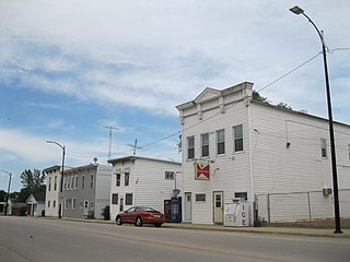
Nora is a village in Jo Daviess County, Illinois, United States. In 2020, the population was 107, down from 121 according to the 2010 census, which was up from 118 in 2000.

<span class="mw-page-title-main">Scales Mound, Illinois</span> Village in Illinois, United States

Scales Mound is a village in Jo Daviess County, Illinois, United States. The population was 436 at the 2020 census.

<span class="mw-page-title-main">Warren, Illinois</span> Village in Illinois, United States

Warren is a village in Jo Daviess County, Illinois, United States. The population was 1,323 at the 2020 census, down from 1,428 at the 2010 census.

<span class="mw-page-title-main">Pearl City, Illinois</span> Village in Illinois, United States

Pearl City is an incorporated village in Stephenson County, Illinois, with a population of 838 at the 2010 census, up from 780 in 2000.

Spring Ridge is a census-designated place (CDP) in Spring Township, Berks County, Pennsylvania, United States. The population was 1,003 at the 2010 census.

<span class="mw-page-title-main">New Diggings, Wisconsin</span> Town in Wisconsin, United States

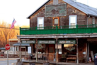
New Diggings is a town in Lafayette County, Wisconsin, United States. The population was 502 at the 2010 census, up from 473 in 2000. The unincorporated communities of Etna, Lead Mine, and New Diggings are located in the town.

Gratiot is a town in Lafayette County, Wisconsin, United States. The population was 550 at the 2010 census, down from 653 at the 2000 census. The village of Gratiot is located within the town. The unincorporated community of Riverside and part of the unincorporated community of Dunbarton are also in the town.

<span class="mw-page-title-main">Elizabeth Township, Jo Daviess County, Illinois</span> Township in Illinois, United States

Elizabeth Township is one of twenty-three townships in Jo Daviess County, Illinois, USA. As of the 2010 census, its population was 1,111 and it contained 579 housing units.

References

  1. Stockton Chamber of Commerce
  2. Village of Stockton
  3. "2020 U.S. Gazetteer Files". United States Census Bureau. Retrieved March 15, 2022.
  4. "USGS detail on Newtown" . Retrieved October 21, 2007.
  5. 1 2 "Google Earth at Stockton, Illinois water tower". Google Earth. Retrieved June 25, 2022.
  6. "Stockton History | Village of Stockton". www.villageofstockton.com. Retrieved January 24, 2019.
  7. Huddleston, Jerry. "CGW's Winston Tunnel", accessed April 7, 2009.
  8. Donth, Cynthia. "W.E. White Building [ permanent dead link ]", (PDF), National Register of Historic Places Registration Form, June 27, 1997, Illinois Historic Preservation Agency , accessed May 4, 2008.
  9. StocktonIL.com "Stockton History Archived 2009-04-18 at the Wayback Machine ", accessed April 7, 2009.
  10. KraftFoodsCompany.com "History of Kraft Foods Archived 2009-04-16 at the Wayback Machine ", accessed April 7, 2009.
  11. Galena, Jo Daviess County Visitors Guide, 2012
  12. "US Gazetteer files: 2010, 2000, and 1990". United States Census Bureau. February 12, 2011. Retrieved April 23, 2011.
  13. "G001 - Geographic Identifiers - 2010 Census Summary File 1". United States Census Bureau. Archived from the original on February 13, 2020. Retrieved December 25, 2015.
  14. "NowData – NOAA Online Weather Data". National Oceanic and Atmospheric Administration. Retrieved July 11, 2021.
  15. "Station: Stockton 3 NNE, IL". U.S. Climate Normals 2020: U.S. Monthly Climate Normals (1991–2020). National Oceanic and Atmospheric Administration. Retrieved July 11, 2021.
  16. "Census of Population and Housing". Census.gov. Retrieved June 4, 2015.
  17. "U.S. Census website". United States Census Bureau . Retrieved January 31, 2008.
  18. "Benton Mound, PeakAdvisor.com". Peak Advisor. Retrieved June 25, 2022.
  19. Leo Binz
  20. 'Illinois Blue Book 1997-1998,' Biographical Sketch of I. Ronald Lawfer, pg. 107