West Fork Millicoma River

Last updated
West Fork Millicoma River
West fork millicoma river.jpg
View from the Oregon Route 241 bridge at Allegany
Name origin:Possibly the Coos people's name for the river [1]
Country United States
State Oregon
County Coos
Sourcenear Elk Peak
 - locationnortheastern Coos County, Southern Oregon Coast Range
 - elevation1,519 ft (463 m) [2]
 - coordinates 43°33′08″N123°53′17″W / 43.55222°N 123.88806°W / 43.55222; -123.88806   [3]
Mouth Millicoma River
 - location Allegany
 - elevation23 ft (7 m) [3]
 - coordinates 43°25′27″N124°01′48″W / 43.42417°N 124.03000°W / 43.42417; -124.03000 Coordinates: 43°25′27″N124°01′48″W / 43.42417°N 124.03000°W / 43.42417; -124.03000   [3]
Length34 mi (55 km) [4]
USA Oregon location map.svg
Red pog.svg
Location of the mouth of the West Fork Millicoma River in Oregon

The West Fork Millicoma River is a tributary, about 34 miles (55 km) long, of the Millicoma River in the U.S. state of Oregon. Rising in northeastern Coos County near the Douglas County line, it flows generally southwest through the Elliott State Forest of the Southern Oregon Coast Range to the community of Allegany. There it joins the East Fork Millicoma River to form the Millicoma. In turn, the Millicoma, which is only about 9 miles (14 km) long, joins the South Fork Coos River to form the Coos River. The Coos River, itself only about 5 miles (8 km) long, empties into the eastern end of Coos Bay, which connects to the Pacific Ocean. [4]

Millicoma River river in the United States of America

The Millicoma River is a coast stream, about 8.5 miles (13.7 km) long, east of Coos Bay in the U.S. state of Oregon. Formed by the confluence of the East Fork Millicoma River and the West Fork Millicoma River at Allegany, it meanders across relatively flat land to meet the South Fork Coos River, with which it forms the Coos River.

U.S. state constituent political entity of the United States

In the United States, a state is a constituent political entity, of which there are currently 50. Bound together in a political union, each state holds governmental jurisdiction over a separate and defined geographic territory and shares its sovereignty with the federal government. Due to this shared sovereignty, Americans are citizens both of the federal republic and of the state in which they reside. State citizenship and residency are flexible, and no government approval is required to move between states, except for persons restricted by certain types of court orders. Four states use the term commonwealth rather than state in their full official names.

Oregon State of the United States of America

Oregon is a state in the Pacific Northwest region on the West Coast of the United States. The Columbia River delineates much of Oregon's northern boundary with Washington, while the Snake River delineates much of its eastern boundary with Idaho. The parallel 42° north delineates the southern boundary with California and Nevada. Oregon is one of only three states of the contiguous United States to have a coastline on the Pacific Ocean.

Contents

Course

Beginning northeast of Elk Peak, the river flows generally north parallel to Umpcoos Ridge before turning west and receiving Cougar Creek from the right and then Kelly Creek from the right about 32 miles (51 km) from the mouth. Over the next 6 miles (9.7 km), Panther Creek enters from the left, Fish Creek from the right, Elk Creek from the left, and Knife, Deer, and Otter creeks from the right. The river turns south, and Joes Creek enters from the right at about river mile (RM) 24.5 or river kilometer (RK) 39.4. About 1.5 miles (2.4 km) further downstream, Buck Creek enters from the right. The next named tributary to enter the river is Trout Creek, which comes in from the right at about RM 19 (RK 31). [4] [5]

River delta Silt deposition landform at the mouth of a river

A river delta is a landform created by deposition of sediment that is carried by a river as the flow leaves its mouth and enters slower-moving or stagnant water. This occurs where a river enters an ocean, sea, estuary, lake, reservoir, or another river that cannot carry away the supplied sediment. The size and shape of a delta is controlled by the balance between watershed processes that supply sediment, and receiving basin processes that redistribute, sequester, and export that sediment. The size, geometry, and location of the receiving basin also plays an important role in delta evolution. River deltas are important in human civilization, as they are major agricultural production centers and population centers. They can provide coastline defense and can impact drinking water supply. They are also ecologically important, with different species' assemblages depending on their landscape position.

River mile

In the United States, a river mile is a measure of distance in miles along a river from its mouth. River mile numbers begin at zero and increase further upstream. The corresponding metric unit using kilometers is the river kilometer. They are analogous to vehicle roadway mile markers, except that river miles are rarely marked on the physical river; instead they are marked on navigation charts, and topographic maps. Riverfront properties are sometimes partially legally described by their river mile.

About 17 miles (27 km) from the mouth, the river turns west and a mile later descends Stulls Falls and turns south once more. Turning west near RM 14 (RK 23), the river goes over Henrys Falls, meandering generally south-southwest thereafter. Schumacher Creek enters from the right before the river passes over Pidgeon Falls and receives Totten and Daggett creeks from the right about 7 miles (11 km) from the mouth. [4] [5] The river then flows by a stream gauge maintained by the Coos Watershed Association. [6] Turning south once again, the river flows around Devils Elbow and receives Rainy Creek from the left before meeting the East Fork Millicoma River at Allegany. [4] [5] The West Fork Millicoma Road runs roughly parallel to the river from Allegany to Stalls Falls, and logging roads reach the headwaters. [7]

Stream gauge locations used to monitor surface water flow

A stream gauge, streamgage or gauging station is a location used by hydrologists or environmental scientists to monitor and test terrestrial bodies of water. Hydrometric measurements of water level surface elevation ("stage") and/or volumetric discharge (flow) are generally taken and observations of biota and water quality may also be made. The location of gauging stations are often found on topographical maps. Some gauging stations are highly automated and may include telemetry capability transmitted to a central data logging facility.

Recreation

The river supports a steelhead fishery as well as good coastal cutthroat trout fishing near the headwaters. A hatchery about 9 miles (14 km) upstream of Allegany releases juvenile steelhead to the lower river, but it is difficult to fish downstream of the hatchery because of limited bank access and the dangers of boating through rapids. However, the hatchery site itself offers bank access. The site also includes an interpretive center that is open to the public. [7]

Rainbow trout species of trout

The rainbow trout is a trout and species of salmonid native to cold-water tributaries of the Pacific Ocean in Asia and North America. The steelhead is an anadromous (sea-run) form of the coastal rainbow trout(O. m. irideus) or Columbia River redband trout (O. m. gairdneri) that usually returns to fresh water to spawn after living two to three years in the ocean. Freshwater forms that have been introduced into the Great Lakes and migrate into tributaries to spawn are also called steelhead.

Coastal cutthroat trout subspecies of fish

The coastal cutthroat trout also known as the sea-run cutthroat trout, or harvest trout is one of the several subspecies of cutthroat trout found in Western North America. The coastal cutthroat trout occurs in four distinct forms. A semi-anadromous or sea-run form is the most well known. Freshwater forms occur in both large and small rivers and streams and lake environments. The native range of the coastal cutthroat trout extends south from the southern coastline of the Kenai Peninsula in Alaska to the Eel River in Northern California. Coastal cutthroat trout are resident in tributary streams and rivers of the Pacific basin and are rarely found more than 100 miles (160 km) from the ocean.

Hatchery facility for incubating and hatching animals

A hatchery is a facility where eggs are hatched under artificial conditions, especially those of fish or poultry. It may be used for ex-situ conservation purposes, i.e. to breed rare or endangered species under controlled conditions; alternatively, it may be for economic reasons.

Whitewater enthusiasts sometimes run a stretch of the river, about 6 to 9 miles (10 to 14 km) long, that begins upstream of Henry's Falls. Obstacles like the falls, a 10-foot (3.0 m) drop, are generally scouted before running and often portaged. [8]

Whitewater bubbly, or aerated and unstable current

Whitewater is formed in a rapid, when a river's gradient increases enough to generate so much turbulence that air is entrained into the water body, that is, it forms a bubbly or aerated and unstable current; the frothy water appears white. The term is also loosely used to refer to less turbulent, but still agitated, flows.

Portage carrying water craft or cargo over land

Portage or portaging is the practice of carrying water craft or cargo over land, either around an obstacle in a river, or between two bodies of water. A path where items are regularly carried between bodies of water is also called a portage.

See also

Related Research Articles

Sandy River (Oregon) tributary of the Columbia River in northwestern Oregon in the United States

The Sandy River is a 56-mile (90 km) tributary of the Columbia River in northwestern Oregon in the United States. The Sandy joins the Columbia about 14 miles (23 km) upstream of Portland.

Clackamas River tributary of the Willamette River in Oregon

The Clackamas River is an approximately 83-mile (134 km) tributary of the Willamette River in northwestern Oregon, in the United States. Draining an area of about 940 square miles (2,435 km2), the Clackamas flows through mostly forested and rugged mountainous terrain in its upper reaches, and passes agricultural and urban areas in its lower third. The river rises in eastern Marion County, about 55 miles (89 km) east-southeast of Salem. The headwaters are on the slopes of Olallie Butte in the Mount Hood National Forest, about 10 miles (16 km) north of Mount Jefferson, at an elevation of 4,909 feet (1,496 m) in the Cascade Range. The Clackamas flows briefly north and then flows northwest through the mountains, passing through North Fork Reservoir and Estacada. It then emerges from the mountains southeast of Portland. It joins the Willamette near Oregon City and forms the boundary between Oregon City and Gladstone.

Coos River Gold

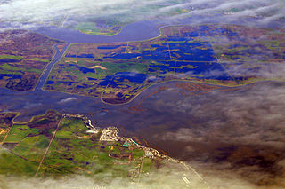
The Coos River flows for about 5 miles (8.0 km) into Coos Bay along the Pacific coast of southwest Oregon in the United States. Formed by the confluence of its major tributaries, the South Fork Coos River and the Millicoma River, it drains an important timber-producing region of the Southern Oregon Coast Range. The course of the main stem and the major tributaries is generally westward from the coastal forests to the eastern end of Coos Bay near the city of Coos Bay.

Siletz River river in the United States of America

The Siletz River flows about 67 miles (108 km) to the Pacific Ocean through coastal mountains in the U.S. state of Oregon. Formed by the confluence of its north and south forks near Valsetz in Polk County, it winds through the Central Oregon Coast Range. The river, draining a watershed of 373 square miles (970 km2), empties into Siletz Bay, south of Lincoln City in Lincoln County. Although the river travels 67 miles (108 km) in river miles, its winding course begins only about 20 miles (32 km) east of the ocean, and its mouth and source latitudes are almost identical.

Elk River (Oregon) river in southwestern Oregon in the United States

The Elk River is in southwestern Oregon in the United States. About 29 miles (47 km) long, the river drains a remote 92-square-mile (240 km2) area of the Coast Range into the Pacific Ocean.

Alsea River river in the United States of America

The Alsea River flows 48.5 miles (78.1 km) from Alsea, an unincorporated community in the coastal mountains of the U.S. state of Oregon, to the Pacific Ocean near the city of Waldport. It begins at the confluence of the North Fork Alsea River and the South Fork Alsea River and ends in Alsea Bay, a wide estuary at Waldport. The river flows generally west-northwest in a winding course through the mountains of southern Benton and Lincoln counties, passing near the unincorporated community of Tidewater and through the Siuslaw National Forest. Its drainage basin extends into Lane County, along the headwaters of the South Fork Alsea River.

Trask River river in Oregon

The Trask River is in northwestern Oregon in the United States. It drains a mountainous timber-producing area of the Northern Oregon Coast Range west of Portland into Tillamook Bay and the Pacific Ocean. It is one of five rivers—the Tillamook, the Trask, the Wilson, the Kilchis, and the Miami—that flow into the bay.

South Santiam River river in the United States of America

The South Santiam River is a tributary of the Santiam River, about 69 miles (111 km) long, in western Oregon in the United States. It drains an area of the Cascade Range into the Willamette Valley east of Corvallis.

Collawash River river in the United States of America

The Collawash River is a 12-mile (19 km) tributary of the Clackamas River in the U.S. state of Oregon. Formed by the confluence of Elk Lake Creek and the East Fork Collawash River in the Cascade Range, it flows generally north-northwest from source to mouth through the Mount Hood National Forest. The largest tributary of the upper Clackamas, it provides about a third of bigger river's low-flow volume. About 35 percent of its watershed of 150 square miles (390 km2) is protected as wilderness.

Abiqua Creek river in Oregon, United States of America

Abiqua Creek is a tributary of the Pudding River in the U.S. state of Oregon. The creek originates near Lookout Mountain in the foothills of the Cascade Range in the northwestern part of the state. It flows northwest for about 29 miles (47 km) to its confluence with the Pudding, about 2 miles (3.2 km) west of Silverton, in the Willamette Valley. About 20 miles (32 km) north of Silverton, the Pudding River meets the Molalla River, which meets the Willamette River less than 1 mile (1.6 km) later near Canby.

Umatilla River tributary of the Columbia River in Oregon

The Umatilla River is an 89-mile (143 km) tributary of the Columbia River in the U.S. state of Oregon. Draining a basin of 2,450 square miles (6,300 km2), it enters the Columbia near the city of Umatilla in the northeastern part of the state. In downstream order, beginning at the headwaters, major tributaries of the Umatilla River are the North Fork Umatilla River and the South Fork Umatilla River, then Meacham, McKay, Birch, and Butter creeks.

Row River river in the United States of America

The Row River is a river, approximately 20 miles (32 km) long, in Lane County, Oregon, United States. It rises in the Cascade Range and flows into the Coast Fork Willamette River near Cottage Grove. The stream was originally known as the "East Fork Coast Fork", but was later renamed after a dispute (row) between neighbors and brothers-in-law George Clark and Joseph Southwell over "trespassing" livestock. Clark was killed as a result of the row. The name rhymes with "cow" rather than with "slow". A post office named Row River operated from 1911 to 1914 a little north of the present site of Dorena at 43.740123°N 122.880347°W.

South Fork Rogue River tributary of the Rogue River in Oregon

The South Fork Rogue River is a 25-mile (40 km) tributary of the Rogue River in the U.S. state of Oregon. Rising in the Sky Lakes Wilderness in the Cascade Range, it flows generally northeast through the Rogue River – Siskiyou National Forest to meet the Rogue River downstream of Prospect and slightly upstream of Lost Creek Lake.

East Fork Millicoma River river in the United States of America

The East Fork Millicoma River is a tributary, about 24 miles (39 km) long, of the Millicoma River in the U.S. state of Oregon. Rising in eastern Coos County, it flows generally west to the community of Allegany, where it joins the West Fork Millicoma River to form the Millicoma. In turn, the Millicoma, which is only about 9 miles (14 km) long, joins the South Fork Coos River to form the Coos River. The Coos River, itself only about 5 miles (8 km) long, empties into the eastern end of Coos Bay, which connects to the Pacific Ocean.

South Fork Coos River river in the United States of America

The South Fork Coos River is a tributary, about 32 miles (51 km) long, of the Coos River in the U.S. state of Oregon. Formed by the confluence of the Williams River and Tioga Creek, it begins in eastern Coos County near the Douglas County line and flows generally northwest through the Southern Oregon Coast Range. East of the city of Coos Bay, it joins the Millicoma River to form the Coos River. This larger river, only about 5 miles (8 km) long, empties into the eastern end of Coos Bay, which connects to the Pacific Ocean.

Williams River (Oregon) river in the United States of America

The Williams River is a tributary, about 21 miles (34 km) long, of the South Fork Coos River in the U.S. state of Oregon. Formed by the confluence of Lost Creek and Little Cow Creek, it begins in western Douglas County near the Coos County line and flows generally northwest through the Southern Oregon Coast Range. In eastern Coos County, it joins Tioga Creek to form the South Fork Coos River about 32 miles (51 km) from its confluence with the Millicoma River.

South Fork McKenzie River tributary of the McKenzie River in Oregon

The South Fork McKenzie River is a tributary, about 31 miles (50 km) long, of the McKenzie River in the U.S. state of Oregon. It begins at about 4,500 feet (1,400 m) above sea level near Mink Lake in the Three Sisters Wilderness of the Cascade Range. Flowing northwest within Lane County, it meets the McKenzie River about 60 miles (97 km) from the larger river's confluence with the Willamette River.

North Fork Alsea River river in the United States of America

The North Fork Alsea River is a 16-mile (26 km) tributary of the Alsea River in the U.S. state of Oregon. It begins at Klickitat Lake, fed by Klickitat and Lake creeks in the Central Oregon Coast Range, and flows generally south to near Alsea, where it joins the South Fork Alsea River to form the main stem. For most of its course, the North Fork winds through the Siuslaw National Forest in Lincoln County and then Benton County. It passes under Oregon Route 34 northeast of Alsea.

East Fork Coquille River river in the United States of America

The East Fork Coquille River is a tributary, about 34 miles (55 km) long, of the North Fork Coquille River in the U.S. state of Oregon. It begins near Bennett Rock in Douglas County in the Southern Oregon Coast Range.

References

  1. McArthur, pp. 64647
  2. Source elevation derived from Google Earth search using GNIS source coordinates.
  3. 1 2 3 "West Fork Millicoma River". Geographic Names Information System. United States Geological Survey. November 28, 1980. Retrieved April 3, 2011.
  4. 1 2 3 4 5 United States Geological Survey. "United States Geological Survey Topographic Map". TopoQuest. Retrieved April 27, 2018. The maps include river mile (RM) markers for the first 32 miles (51 km). The last 2 miles (3 km) near the headwaters is an estimate based on map scale and ruler. Relevant map quadrangles from mouth to source are Allegany, Golden Falls, Trail Butte, and Elk Peak.
  5. 1 2 3 Oregon Atlas and Gazetteer (Map) (1991 ed.). DeLorme Mapping. § 33, 40. ISBN   978-0-89933-347-2.
  6. "West Fork Millicoma River Gaging Station". Coos Watershed Association. Retrieved April 3, 2011.
  7. 1 2 Sheehan, pp. 8081
  8. Giordano, pp. 6869

Works cited

International Standard Book Number Unique numeric book identifier

The International Standard Book Number (ISBN) is a numeric commercial book identifier which is intended to be unique. Publishers purchase ISBNs from an affiliate of the International ISBN Agency.