Yardley, Pennsylvania

Last updated

Yardley, Pennsylvania
Yardley HD Main St 15.JPG
Yardley Borough Hall
Yardley Seal.png
Bucks County Pennsylvania Incorporated and Unincorporated areas Yardley Highlighted.svg
Location of Yardley in Bucks County, Pennsylvania (left) and of Bucks County in Pennsylvania (right)
USA Pennsylvania location map.svg
Red pog.svg
Yardley
Location of Yardley in Pennsylvania
Usa edcp location map.svg
Red pog.svg
Yardley
Yardley (the United States)
Coordinates: 40°14′29″N74°50′11″W / 40.24139°N 74.83639°W / 40.24139; -74.83639
Country Flag of the United States.svg  United States
State Flag of Pennsylvania.svg  Pennsylvania
County Bucks
Founded1682
IncorporatedMarch 4, 1895
Government
  MayorChris Harding [1] (R)
Area
[2]
  Total1.02 sq mi (2.64 km2)
  Land0.93 sq mi (2.42 km2)
  Water0.09 sq mi (0.22 km2)  8.8%
Elevation
46 ft (14 m)
Population
 (2010)
  Total2,480
  Estimate 
(2019) [3]
2,514
  Density2,691.65/sq mi (1,039.33/km2)
Time zone UTC−5 (EST)
  Summer (DST) UTC−4 (EDT)
ZIP Code
19067
Area code(s) 215, 267 and 445
FIPS code 42-86920
Website www.yardleyboro.com

Yardley is a borough in Bucks County, Pennsylvania, United States. Yardley borders the Delaware River and Ewing, New Jersey to its east and Lower Makefield Township to its north, west, and south. The United States Post Office assigns many addresses in Lower Makefield Township the preferred city of "Yardley", although they are outside the borough. The population was 2,434 at the 2010 census. Yardley is part of the Delaware Valley metropolitan area.

Contents

Geography

Yardley is located at 40°14′29″N74°50′11″W / 40.24139°N 74.83639°W / 40.24139; -74.83639 (40.241508, -74.836325). [4] According to the U.S. Census Bureau, the borough has a total area of 1.0 square mile (2.6 km2), of which 0.9 square miles (2.3 km2) is land and 0.1 square miles (0.26 km2) (9.90%) is water.

The Delaware Canal and its towpath bisect the borough from northwest to southeast. Access points to the canal are located at Edgewater Avenue, Afton Avenue, Fuld Avenue, College Avenue and South Canal Street.

The Yardley station, a SEPTA Regional Rail station, is located on Main Street.

Demographics

Historical population
CensusPop.Note
1880 820
1890 813−0.9%
1900 714−12.2%
1910 89425.2%
1920 1,26241.2%
1930 1,3083.6%
1940 1,45911.5%
1950 1,91631.3%
1960 2,27118.5%
1970 2,61615.2%
1980 2,533−3.2%
1990 2,288−9.7%
2000 2,4989.2%
2010 2,434−2.6%
2020 2,6057.0%
Sources: [5] [6] [7] [8]

As of the 2010 census, the borough was 89.7% Non-Hispanic White, 3.5% Black or African American, 2.6% Asian, and 1.9% were two or more races. 2.5% of the population were of Hispanic or Latino ancestry.

As of the census [6] of 2000, there were 2,498 people, 1,170 households, and 649 families residing in the borough. The population density was 2,729.0 inhabitants per square mile (1,053.7/km2). There were 1,209 housing units at an average density of 1,320.8 per square mile (510.0/km2). The racial makeup of the borough was 93.63% White, 3.44% African American, 0.08% Native American, 1.20% Asian, 0.04% Pacific Islander, 0.52% from other races, and 1.08% from two or more races. 1.76% of the population were Hispanic or Latino of any race.

There were 1,170 households, out of which 24.4% had children under the age of 18 living with them, 43.9% were married couples living together, 8.6% had a female householder with no husband present, and 44.5% were non-families. 37.0% of all households were made up of individuals, and 10.8% had someone living alone who was 65 years of age or older. The average household size was 2.14 and the average family size was 2.86.

In the borough, the population was spread out, with 20.4% under the age of 18, 4.8% from 18 to 24, 35.3% from 25 to 44, 24.9% from 45 to 64, and 14.7% who were 65 years of age or older. The median age was 40 years. For every 100 females, there were 90.7 males. For every 100 females age 18 and over, there were 86.3 males.

The median income for a household in the township was $58,221, and the median income for a family was $70,938. Males had a median income of $50,816 versus $41,893 for females. The per capita income for the township was $32,802. About 1.7% of families and 3.1% of the population were below the poverty line, including 2.6% of those under age 18 and 3.3% of those age 65 or over.

History

Yardley was founded by William Yardley, who emigrated to America in July, 1682 with his family. He made an agreement with William Penn, before leaving England, to buy 500 acres (2.0 km2) for ten pounds. A survey was completed in October 1682, and the area William Yardley settled was called "Prospect Farm." It was located just outside the present Yardley Borough. William Yardley died in 1693, and his family in 1702–1703, possibly of smallpox. The family's burial plots are located in Slate Hill Cemetery, one of the oldest Quaker burial grounds in the state. [9]

A nephew, Thomas Yardley, came to America in 1704 to settle the estate and never returned to England. He opened a ferry line which started operating in 1710 from Letchworth Avenue, the lower boundary of the village, and landed in New Jersey further downstream. This was an important link between West Jersey and the three roads leading to Philadelphia by way of Falls, Langhorne and Newtown. The Yardley family occupied the land for more than 150 years. When Yardley was founded there were already small settlements at nearby Burlington, Bristol, and Falls Ferry.

Yardley began to develop into a village about 1807, and by 1880 had a population of 820. Early industries included a spoke and handle factory, sawmill, felloe factory, plate and plaster mill, and two flour mills. The first post office, established in 1828, used the name "Yardleyville." The name became "Yardley" again at the time the Reading Railroad came through the area in 1876.

During the American Civil War, Yardley was a station for the Underground Railroad, an escape route for slaves. Known hiding places were under the eaves of the Continental Hotel (now the Continental Tavern), in bins of warehouses on the Delaware Canal (completed in 1862), and at the General Store (now Worthington Insurance). At Lakeside, the yellow house facing Lake Afton on N. Main Street, one brick-walled cellar room is also thought to have been a hiding place.

The borough of Yardley was incorporated on March 4, 1895.

The Train Collectors Association was founded in Yardley in 1954. [10]

The former Bridge in Yardley Borough, Washington Crossing State Park, and Yardley Historic District are listed on the National Register of Historic Places. [11]

Transportation

PA 32 northbound in Yardley 2022-09-19 13 58 24 View north along Pennsylvania State Route 32 (Delaware Avenue) just north of Pennsylvania State Route 332 (Afton Avenue) in Yardley, Bucks County, Pennsylvania.jpg
PA 32 northbound in Yardley

As of 2014 there were 10.64 miles (17.12 km) of public roads in Yardley, of which 3.74 miles (6.02 km) were maintained by the Pennsylvania Department of Transportation (PennDOT) and 6.90 miles (11.10 km) were maintained by the borough. [12]

Pennsylvania Route 32 runs through Yardley adjacent to the Delaware River, heading south to Morrisville and north to New Hope and beyond and is a scenic byway. Pennsylvania Route 332 heads west from PA 32 in Yardley and leads to Newtown.

A SEPTA Regional Rail train on the West Trenton Line stops at the Yardley station SEPTA Silverliner IV 406 at Yardley station.jpeg
A SEPTA Regional Rail train on the West Trenton Line stops at the Yardley station

The Philadelphia to Bound Brook, New Jersey, two-track main line of the Philadelphia and Reading Railroad passed through and stopped at Yardley, It crossed the Delaware River on a still standing massive stone viaduct called the West Trenton Railroad Bridge. This line now is SEPTA Regional Rail's West Trenton Line and operates also as a CSX freight line called the Trenton Subdivision.

SEPTA trains along the West Trenton Line stop at the Yardley station. Prior to the 1950s, the Baltimore and Ohio Railroad's New York City-bound trains from Washington, D.C., (Royal Blue, Capitol Limited, National Limited, Ambassador, and others) used the Reading's trackage to Bound Brook as did the Reading's Crusader.

Historic timeline

Yardley Historic District
Yardley HD Main St 25.JPG
94 S Main St., Yardley
USA Pennsylvania location map.svg
Red pog.svg
Usa edcp location map.svg
Red pog.svg
LocationRoughly bounded by Main St., Afton Ave., Letchworth Ave., Canal St., S. Edgewater Ave., and Delaware Canal, Yardley, Pennsylvania
NRHP reference No. 05000417 [13]

Climate

According to the Köppen climate classification system, Yardley has a Humid subtropical climate (Cfa). Cfa climates are characterized by all months having an average mean temperature > 32.0 °F (0.0 °C), at least four months with an average mean temperature ≥ 50.0 °F (10.0 °C), at least one month with an average mean temperature ≥ 71.6 °F (22.0 °C) and no significant precipitation difference between seasons. Although most summer days are slightly humid in Yardley, episodes of heat and high humidity can occur with heat index values > 108 °F (42 °C). Since 1981, the highest air temperature was 103.9 °F (39.9 °C) on July 20, 2011, and the highest daily average mean dew point was 75.0 °F (23.9 °C) on July 20, 1981. The average wettest month is July, which corresponds with the annual peak in thunderstorm activity. Since 1981, the wettest calendar day was 5.85 inches (149 mm) on September 16, 1999. During the winter months, the average annual extreme minimum air temperature is 1.0 °F (−17.2 °C). [14] Since 1981, the coldest air temperature was −10.4 °F (−23.6 °C) on January 22, 1984. Episodes of extreme cold and wind can occur, with wind chill values < −9 °F (−23 °C). The average annual snowfall (Nov–Apr) is between 24 inches (61 cm) and 30 inches (76 cm). Ice storms and large snowstorms depositing ≥ 12 inches (30 cm) of snow occur once every few years, particularly during nor’easters from December through February.

Climate data for Yardley, Elevation 43 ft (13 m), 1991–2020 normals, extremes 1981–2018
MonthJanFebMarAprMayJunJulAugSepOctNovDecYear
Record high °F (°C)71.7
(22.1)
77.7
(25.4)
87.7
(30.9)
94.3
(34.6)
95.4
(35.2)
96.7
(35.9)
103.9
(39.9)
99.8
(37.7)
98.4
(36.9)
89.6
(32.0)
81.1
(27.3)
75.9
(24.4)
103.9
(39.9)
Mean daily maximum °F (°C)40.7
(4.8)
43.5
(6.4)
51.7
(10.9)
63.9
(17.7)
73.3
(22.9)
82.6
(28.1)
86.9
(30.5)
85.1
(29.5)
78.2
(25.7)
66.9
(19.4)
55.9
(13.3)
44.8
(7.1)
64.5
(18.1)
Daily mean °F (°C)32.4
(0.2)
34.6
(1.4)
41.9
(5.5)
52.7
(11.5)
62.0
(16.7)
71.6
(22.0)
76.2
(24.6)
74.6
(23.7)
67.4
(19.7)
55.8
(13.2)
46.2
(7.9)
36.5
(2.5)
54.4
(12.4)
Mean daily minimum °F (°C)24.1
(−4.4)
25.7
(−3.5)
32.1
(0.1)
41.5
(5.3)
50.7
(10.4)
60.5
(15.8)
65.6
(18.7)
64.0
(17.8)
56.6
(13.7)
44.8
(7.1)
36.6
(2.6)
28.3
(−2.1)
44.3
(6.8)
Record low °F (°C)−10.4
(−23.6)
−2.4
(−19.1)
4.1
(−15.5)
18.1
(−7.7)
33.6
(0.9)
41.6
(5.3)
47.8
(8.8)
42.5
(5.8)
35.9
(2.2)
25.2
(−3.8)
12.2
(−11.0)
0.3
(−17.6)
−10.4
(−23.6)
Average precipitation inches (mm)3.55
(90)
2.81
(71)
4.27
(108)
3.99
(101)
4.20
(107)
4.39
(112)
5.29
(134)
4.24
(108)
4.43
(113)
3.75
(95)
3.60
(91)
4.09
(104)
48.61
(1,235)
Average relative humidity (%)65.461.457.556.661.765.766.068.169.368.366.666.264.4
Average dew point °F (°C)21.6
(−5.8)
22.7
(−5.2)
28.0
(−2.2)
37.7
(3.2)
48.7
(9.3)
59.5
(15.3)
64.0
(17.8)
63.4
(17.4)
57.0
(13.9)
45.5
(7.5)
35.7
(2.1)
26.3
(−3.2)
42.6
(5.9)
Source: PRISM [15]

Ecology

According to the A. W. Kuchler U.S. potential natural vegetation types, Yardley would have a dominant vegetation type of Appalachian Oak (104) with a dominant vegetation form of Eastern Hardwood Forest (25). [16] The plant hardiness zone is 7a with an average annual extreme minimum air temperature of 1.0 °F (−17.2 °C). [14] The spring bloom typically begins by April 7 and fall color usually peaks by November 3.

Notable people

Related Research Articles

<span class="mw-page-title-main">Bucks County, Pennsylvania</span> County in Pennsylvania, United States

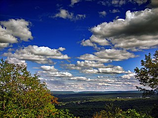
Bucks County is a county in the Commonwealth of Pennsylvania. As of the 2020 census, the population was 646,538, making it the fourth-most populous county in Pennsylvania. Its county seat is Doylestown. The county is named after the English county of Buckinghamshire.

<span class="mw-page-title-main">Boyertown, Pennsylvania</span> Borough in Pennsylvania, United States

Boyertown is a borough in Berks County, Pennsylvania, United States. The population was 4,055 at the 2010 census. Boyertown is known for the many painted fiberglass bears that can be found throughout the town and borough.

<span class="mw-page-title-main">Hamburg, Pennsylvania</span> Borough in Pennsylvania, United States

Hamburg is a borough in Berks County, Pennsylvania, United States. The population was 4,270 at the 2020 census. The town is thought to have been named after Hamburg, Germany, but this is likely to have been a corruption of Bad Homburg.

<span class="mw-page-title-main">Bristol, Pennsylvania</span> Borough in Pennsylvania, United States

Bristol is a borough in Bucks County, Pennsylvania, United States. It is located 23 miles (37 km) northeast of Center City Philadelphia, opposite Burlington, New Jersey on the Delaware River.

<span class="mw-page-title-main">Bristol Township, Pennsylvania</span> Township in Pennsylvania, United States

Bristol Township is a township in Bucks County, Pennsylvania, United States. The population was 54,582 at the 2010 census, making it the 13th largest municipality in the state. Bristol Township, along with Bristol Borough, is a cultural hub for Lower Bucks County, hosting celebrations of African and Latino heritage. Parts of the township consist of the neighborhoods of Fairless Hills and Levittown. It is located within the Delaware Valley.

<span class="mw-page-title-main">Buckingham Township, Bucks County, Pennsylvania</span> Township in Pennsylvania, United States

Buckingham Township is a township in Bucks County, Pennsylvania, United States. The population was 20,075 at the 2010 census. Buckingham takes its name from Buckingham in Buckinghamshire, England. Buckingham Township was once known as Greenville and was once the historic county seat of the English Bucks County.

<span class="mw-page-title-main">Falls Township, Bucks County, Pennsylvania</span> Township in Pennsylvania, United States

Falls Township is a suburban Philadelphia township in Bucks County, Pennsylvania, United States. The population was 34,300 at the 2010 census. Portions of Fairless Hills and Levittown, Pennsylvania, are located in the township. Portions of Falls Township are called Morrisville and Yardley, due to the location of the Morrisville Post Office outside the Borough of Morrisville in Falls Township. As originally chartered in 1692, the villages of Morrisville and Tullytown were part of Falls Township. Morrisville was granted borough status in 1804. Tullytown was established as a borough in 1891.

<span class="mw-page-title-main">Langhorne, Pennsylvania</span> Borough in Pennsylvania, United States

Langhorne Borough is a borough in Bucks County, Pennsylvania, United States. The population was 1,622 at the time of the 2010 census.

<span class="mw-page-title-main">Lower Makefield Township, Pennsylvania</span> Township in Pennsylvania, United States

Lower Makefield Township is a township in Bucks County, Pennsylvania, United States. Lower Makefield Township is located in the Delaware Valley and borders the Delaware River and New Jersey to its north and east. Most addresses in the township have a Yardley address; the township surrounds the borough of Yardley on its north, south, and west.

<span class="mw-page-title-main">Morrisville, Bucks County, Pennsylvania</span> Borough in Pennsylvania, United States

Morrisville is a borough in Bucks County, Pennsylvania, United States. It is located just below the falls of the Delaware River opposite Trenton, New Jersey. The population was 9,809 in the 2020 Census.

<span class="mw-page-title-main">New Hope, Pennsylvania</span> Borough in Pennsylvania, United States

New Hope is a borough in Bucks County, Pennsylvania, United States. The population was 2,612 at the 2020 census. New Hope is located approximately 30 mi (48 km) north of Philadelphia, and lies on the west bank of the Delaware River at its confluence with Aquetong Creek. New Hope and neighboring Solebury and Upper Makefield townships are part of the Philadelphia metropolitan area. The two-lane New Hope–Lambertville Bridge carries automobile and foot traffic across the Delaware to Lambertville, New Jersey, on the east bank. New Hope's primary industry is tourism.

<span class="mw-page-title-main">Newtown, Bucks County, Pennsylvania</span> Borough in Pennsylvania, United States

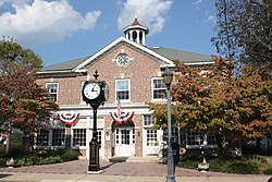
Newtown is a borough in Bucks County, Pennsylvania, United States. The population was 2,268 at the 2020 census. It is located just west of the Trenton, New Jersey metropolitan area, and is part of the larger Philadelphia metropolitan area. It is entirely surrounded by Newtown Township, from which it separated in 1838. State Street is the main commercial thoroughfare with wide sidewalks, shops, taverns, and restaurants.

<span class="mw-page-title-main">Penndel, Pennsylvania</span> Borough in Pennsylvania, United States

Penndel is a borough in Bucks County, Pennsylvania, United States. The population was 2,328 at the 2010 census.

<span class="mw-page-title-main">Riegelsville, Pennsylvania</span> Borough in Pennsylvania, United States

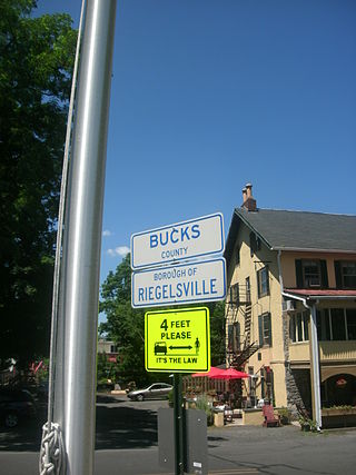
Riegelsville is a borough in Bucks County, Pennsylvania, United States. The population was 868 at the 2010 census. It is included in the Philadelphia–Wilmington–Camden metropolitan statistical area, despite being so closely connected to the Lehigh Valley.

<span class="mw-page-title-main">Tullytown, Pennsylvania</span> Borough in Pennsylvania, United States

Tullytown is a borough in Bucks County, Pennsylvania, United States. Originally a village in Falls Township, Tullytown was partitioned as a borough in 1891. The population was 1,872 at the 2010 census. Part of Levittown is located in Tullytown.

<span class="mw-page-title-main">Upper Makefield Township, Pennsylvania</span> Township in Pennsylvania, United States

Upper Makefield Township is a township in Bucks County, Pennsylvania. The population was 8,190 at the 2010 census. It has the eighth-highest per capita income among all townships in Pennsylvania.

<span class="mw-page-title-main">Delaware Water Gap, Pennsylvania</span> Borough in Pennsylvania, United States

Delaware Water Gap is a borough in Monroe County, Pennsylvania, United States. It is located adjacent to the Delaware Water Gap, the pass through which the Lackawanna Corridor and Interstate 80 run across the Pennsylvania-New Jersey border along the Delaware River.

<span class="mw-page-title-main">East Stroudsburg, Pennsylvania</span> Borough in Pennsylvania, United States

East Stroudsburg is a borough in Monroe County, Pennsylvania, and part of the Pocono Mountains region of the state. Originally known as Dansbury, East Stroudsburg was renamed for geographic reasons when the Delaware, Lackawanna, and Western Railroad opened a station in East Stroudsburg. Despite its name being derivative of its bordering borough, Stroudsburg, it has almost twice the population. East Stroudsburg is the largest municipality in Monroe County and in the East Stroudsburg, Pennsylvania, Metropolitan Statistical Area as designated by the Office of Management and Budget based on data from the 2010 US Census.

<span class="mw-page-title-main">Mount Pocono, Pennsylvania</span> Place in Pennsylvania, United States

Mount Pocono is a borough in Monroe County, Pennsylvania. It is located nearly centered in the southernmost county of five in the northeastern corner that are part of the Pocono Mountains. The borough serves as a local highway nexus, and sees a lot of tourist traffic making use of resources in the region. As of the 2020 census, the borough population was 3,083 residents.

<span class="mw-page-title-main">West Trenton Railroad Bridge</span> Bridge in Mercer County, New Jersey

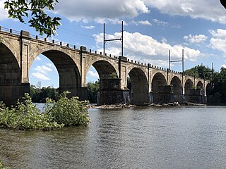
The West Trenton Railroad Bridge is a concrete arch bridge carrying CSX's Trenton Subdivision and SEPTA's West Trenton Line across the Delaware River between Lower Makefield Township in Bucks County, Pennsylvania and the West Trenton section of Ewing Township in Mercer County, New Jersey. It was originally designed by the Philadelphia and Reading Railroad and was constructed from 1911 to 1913 by the F. W. Talbot Construction Company.

References

  1. "2021 Municipal Election (11/02/2021)" (PDF). December 27, 2021. pp. 1–55. Retrieved March 6, 2023.
  2. "2019 U.S. Gazetteer Files". United States Census Bureau. Retrieved July 28, 2020.
  3. "Population and Housing Unit Estimates". United States Census Bureau. May 24, 2020. Retrieved May 27, 2020.
  4. "US Gazetteer files: 2010, 2000, and 1990". United States Census Bureau. February 12, 2011. Retrieved April 23, 2011.
  5. "Census of Population and Housing". U.S. Census Bureau. Retrieved December 11, 2013.
  6. 1 2 "U.S. Census website". United States Census Bureau . Retrieved January 31, 2008.
  7. "Incorporated Places and Minor Civil Divisions Datasets: Subcounty Resident Population Estimates: April 1, 2010 to July 1, 2012". Population Estimates. U.S. Census Bureau. Retrieved December 11, 2013.
  8. "Census 2020".
  9. Video, youtube.com. Accessed September 15, 2022.
  10. "About TCA". tcatrains.org. Retrieved August 9, 2023.
  11. "National Register Information System". National Register of Historic Places . National Park Service. July 9, 2010.
  12. "Yardley Borough map" (PDF). PennDOT. Retrieved March 11, 2023.
  13. "National Register Information System". National Register of Historic Places . National Park Service. January 23, 2007.
  14. 1 2 "USDA Interactive Plant Hardiness Map". United States Department of Agriculture. Archived from the original on July 4, 2019. Retrieved October 18, 2019.
  15. "PRISM Climate Group, Oregon State University" . Retrieved October 18, 2019.
  16. "U.S. Potential Natural Vegetation, Original Kuchler Types, v2.0 (Spatially Adjusted to Correct Geometric Distortions)" . Retrieved October 17, 2019.
  17. Yaqoob, Tahira (April 26, 2012). "Arab-American novelist fights for justice in Palestine". The National . Abu Dhabi. Retrieved March 30, 2023.
  18. Zucker, Noah (June 20, 2022). "Emo band Algernon Cadwallader reunites for first tour in 10 years". Philly Voice. Retrieved August 6, 2023.
  19. Hunt, Kristin (May 10, 2023). "Yardley native brings Dr. Teeth, the Swedish Chef and other Muppet characters to life". Philly Voice. Retrieved August 6, 2023.
  20. Ben-Yaacov, Shai (May 1, 2017). "The new host of PBS's Washington Week grew up in Yardley, Pa". WHYY. Retrieved August 6, 2023.
  21. Petrosky, Maureen (June 28, 2021). "Yardley's Swim Star David Curtiss Fresh Off the Olympic Trials". Bucks Happening. Retrieved July 17, 2021.
  22. Bullock, Mac (January 14, 2023). "Yardley Native Among Dozens Canned At MSNBC: Report". Daily Voice. Retrieved August 6, 2023.
  23. "Kristin Minter". Rotten Tomatoes. Retrieved August 6, 2023.
  24. Costra, Cody. "Colorado Springs Switchbacks FC Sign Defender Jimmy Ockford". www.switchbacksfc.com. Retrieved May 24, 2021.
  25. Glover, Sarah (February 3, 2022). "'Everything happens for a reason': Yardley's Brian O'Neill ready for 'second chance' at the Olympics". Philadelphia Inquirer. Retrieved August 6, 2023.
  26. Rein, Richard K. (July 12, 1982). "Freckles and Charm". People .
  27. Roche, Eddie. "MODEL ATHENA HIDDLESTON'S SUPERMODEL "BIG SISTERS"". Daily Front Row.
  28. Glover, Sarah (October 18, 2013). "10 Questions: Matthew Schuler of "The Voice"". NBC Philadelphia. Retrieved August 6, 2023.
  29. "Bo Welch". www.tcm.com. Retrieved August 6, 2023.
  30. "WATCH: 'The Office' Star Talks About Growing Up in Bucks County". wpst.com. January 18, 2020. Retrieved February 27, 2021.