Aldan, Pennsylvania

Last updated

Aldan, Pennsylvania
Aldan PA Municipal Building.JPG
Municipal Building
Delaware County Pennsylvania incorporated and unincorporated areas Aldan highlighted.svg
Location in Delaware County and the U.S. state of Pennsylvania
USA Pennsylvania location map.svg
Red pog.svg
Aldan
Location in Pennsylvania
Usa edcp location map.svg
Red pog.svg
Aldan
Location in the United States
Coordinates: 39°55′14″N75°17′12″W / 39.92056°N 75.28667°W / 39.92056; -75.28667
CountryUnited States
StatePennsylvania
County Delaware
Government
  MayorMichael Ceci
Area
[1]
  Total0.60 sq mi (1.55 km2)
  Land0.60 sq mi (1.55 km2)
  Water0.00 sq mi (0.00 km2)
Elevation
128 ft (39 m)
Population
 (2020) [2]
  Total4,244
  Density7,108.88/sq mi (2,746.01/km2)
Time zone UTC-5 (EST)
  Summer (DST) UTC-4 (EDT)
ZIP code
19018 [3]
Area code(s) 610, 484
FIPS code 42-00676
Website www.aldan-boro.org

Aldan is a borough in Delaware County, Pennsylvania, United States. The population was 4,244 at the 2020 census.

Contents

Government

Aldan Borough is governed by a mayor and a borough council consisting of seven members. All offices are four-year terms, with the terms of the council seats staggered (four seats are up in 2023; three seats will be up in 2025).

The Aldan Police Department is appointed by the borough council. The management team consists of a chief, a sergeant and a sergeant detective and is supported by approximately nine patrol officers. [4]

Aldan Borough is part of the Pennsylvania 5th Congressional District, represented by Rep. Mary Gay Scanlon, the Pennsylvania House of Representatives, District 163, represented by Heather Boyd and the Pennsylvania Senate, District 26, represented by Tim Kearney.

Geography

According to the U.S. Census Bureau, the borough has a total area of 0.6 square miles (1.6 km2), all land.

Transportation

Providence Road in Aldan 2022-10-24 14 11 06 View northeast along Providence Road just northeast of Clifton Avenue in Aldan, Delaware County, Pennsylvania.jpg
Providence Road in Aldan

In 2010, there were 13.05 miles (21.00 km) of public roads in Aldan, of which 3.00 miles (4.83 km) were maintained by the Pennsylvania Department of Transportation (PennDOT) and 10.05 miles (16.17 km) were maintained by the borough. [5]

No numbered highways serve Aldan directly. The main thoroughfares include Providence Road and Clifton Avenue, which intersect near the center of town.

Demographics

Historical population
CensusPop.Note
1900 296
1910 661123.3%
1920 1,13671.9%
1930 2,26999.7%
1940 2,64216.4%
1950 3,43029.8%
1960 4,32426.1%
1970 5,00115.7%
1980 4,671−6.6%
1990 4,549−2.6%
2000 4,313−5.2%
2010 4,152−3.7%
2020 4,2442.2%
[6] [2]

As of the 2020 census, the racial make-up of the borough was 54.6% White (non-Hispanic), 37.8% Black/African American, 2.05% Asian, 1.33% other races and 2.19% from two or more races. Hispanic or Latino of any race were 2.078% of the population. [7]

At the 2000 census, [8] there were 4,313 people, 1,751 households and 1,157 families residing in the borough. The population density was 7,235.4 per square mile (2,793.6/km2). There were 1,817 housing units at an average density of 3,048.1 per square mile (1,176.9/km2). The racial make-up of the borough was 93.30% White, 4.34% African American, 0.19% Native American, 1.34% Asian, 0.12% from other races and 0.72% from two or more races. Hispanic or Latino of any race were 0.93% of the population.

There were 1,751 households, of which 28.6% had children under the age of 18 living with them, 51.6% were married couples living together, 10.1% had a female householder with no husband present and 33.9% were non-families. 29.5% of all households were made up of individuals and 12.8% had someone living alone who was 65 years of age or older. The average household size was 2.46 and the average family size was 3.08.

22.8% of the population were under the age of 18, 6.9% from 18 to 24, 30.4% from 25 to 44, 24.1% from 45 to 64 and 15.9% were 65 years of age or older. The median age was 39 years. For every 100 females there were 90.3 males. For every 100 females age 18 and over, there were 86.1 males.

The median household income was $47,292 and the median family income was $59,595. Males had a median income of $42,047 and females $31,129. The per capita income was $22,134. About 4.0% of families and 5.9% of the population were below the poverty line, including 6.5% of those under age 18 and 12.4% of those age 65 or over.

Notable features

Aldan has a trolley stop museum, a swim club, a non-denominational church named Aldan Union Church, a municipal building and a Veterans Memorial that has been expanded into a park outside of Aldan Elementary School.

Parks

Education

William Penn School District serves Aldan. [9] The district was created in 1972; prior to that year, Aldan was in the Lansdowne-Aldan School District. [10]

Related Research Articles

<span class="mw-page-title-main">Elverson, Pennsylvania</span> Borough in Pennsylvania, United States

Elverson is a borough in Chester County, Pennsylvania, United States. The population was 1,332 at the 2020 census.

<span class="mw-page-title-main">Oxford, Pennsylvania</span> Borough in Pennsylvania, United States

Oxford is a borough in Chester County, Pennsylvania, United States. Oxford is the closest town to Lincoln University. The population was 5,733 at the 2020 census.

<span class="mw-page-title-main">Parkesburg, Pennsylvania</span> Borough in Pennsylvania, United States

Parkesburg is a borough in Chester County, Pennsylvania, United States. The population was counted as 3,866 at the 2020 census. The ZIP code is 19365.

<span class="mw-page-title-main">Spring City, Pennsylvania</span> Borough in Pennsylvania, United States

Spring City is a borough in Chester County, Pennsylvania, United States. The population was 3,494 at the 2020 census. Spring City is a member of the Spring-Ford Area School District.

<span class="mw-page-title-main">Clifton Heights, Pennsylvania</span> Borough in Pennsylvania, United States

Clifton Heights is a borough in Delaware County, Pennsylvania, United States, located on Darby Creek 5 miles (8 km) west of downtown Philadelphia. As of the 2020 census, the population was 6,863.

<span class="mw-page-title-main">Collingdale, Pennsylvania</span> Borough in Pennsylvania, United States

Collingdale is a borough in Delaware County, Pennsylvania, United States. The population was 8,908 at the 2020 census.

<span class="mw-page-title-main">Darby, Pennsylvania</span> Borough in Pennsylvania, United States

Darby is a borough in Delaware County, Pennsylvania, United States. The borough is located along Darby Creek 5 miles (8.0 km) southwest of Center City Philadelphia. The borough of Darby is distinct from the nearby municipality of Darby Township.

<span class="mw-page-title-main">East Lansdowne, Pennsylvania</span> Borough in Pennsylvania, United States

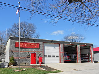
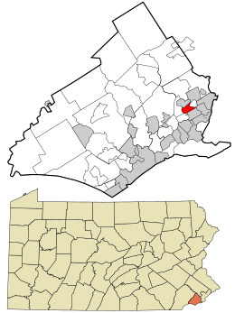
East Lansdowne is a borough in Delaware County, Pennsylvania, United States. The population was 2,668 at the 2010 census.

<span class="mw-page-title-main">Glenolden, Pennsylvania</span> Borough in Pennsylvania, United States

Glenolden is a borough in Delaware County, Pennsylvania, United States. The population was 7,153 at the 2010 census, down from 7,476 at the 2000 census.

<span class="mw-page-title-main">Lansdowne, Pennsylvania</span> Borough in Pennsylvania, United States

Lansdowne is a borough in Delaware County, Pennsylvania, United States, located 6 miles (10 km) southwest of Center City Philadelphia. It was named for the Marquess of Lansdowne. As of the 2010 census, the borough had a population of 10,620.

<span class="mw-page-title-main">Parkside, Pennsylvania</span> Borough in Pennsylvania, United States

Parkside is a borough in Delaware County, Pennsylvania, United States. The population was 2,328 at the 2010 census.

<span class="mw-page-title-main">Prospect Park, Pennsylvania</span> Borough in Pennsylvania, United States

Prospect Park is a borough in Delaware County, Pennsylvania, United States. The population was 6,454 at the 2010 census, down from 6,594 at the 2000 census. It originated as a bedroom community of Philadelphia. It is located within 10 miles (16 km) of Center City, Philadelphia, with convenient rail access.

<span class="mw-page-title-main">Sharon Hill, Pennsylvania</span> Borough in Pennsylvania, United States

Sharon Hill is a borough in Delaware County, Pennsylvania, United States. The population was 5,697 at the 2010 census. Currently the population stands at 6,356 residents.

<span class="mw-page-title-main">Swarthmore, Pennsylvania</span> Borough in Pennsylvania, United States

Swarthmore is a borough in Delaware County, Pennsylvania, United States. Swarthmore was originally named "Westdale" in honor of noted painter Benjamin West, who was one of the early residents of the town. The name was changed to "Swarthmore" after the establishment of Swarthmore College. The borough population was 6,194 as of the 2010 census.

<span class="mw-page-title-main">Yeadon, Pennsylvania</span> Borough in Pennsylvania, United States

Yeadon is a borough in Delaware County, Pennsylvania, United States. It borders the city of Philadelphia. The population was 11,443 at the 2010 census.

<span class="mw-page-title-main">Green Lane, Pennsylvania</span> Borough in Pennsylvania, United States

Green Lane is a borough in Montgomery County, Pennsylvania. The population was 490 at the 2020 census. It is part of the Upper Perkiomen School District and Boyertown Area School District.

<span class="mw-page-title-main">Lower Providence Township, Pennsylvania</span> Township in Pennsylvania, United States

Lower Providence Township is a township in Montgomery County, Pennsylvania, United States. The township is located approximately 17 miles northwest of Philadelphia. The population was 25,625 at the 2020 census.

<span class="mw-page-title-main">Pennsburg, Pennsylvania</span> Borough in Pennsylvania, United States

Pennsburg is a borough in Montgomery County, Pennsylvania. Its population was 3,889 at the 2020 census. It is part of the Upper Perkiomen School District. It is also part of the strip of small towns that run together along Route 29: Red Hill, Pennsburg, and East Greenville. The towns are collectively referred to as Upper Perk.

<span class="mw-page-title-main">Chester Township, Pennsylvania</span> Home rule municipality in Pennsylvania, United States

Chester Township is a township in Delaware County, Pennsylvania, United States. The population was 3,940 at the 2010 census, down from 4,604 at the 2000 census.

<span class="mw-page-title-main">Upper Providence Township, Delaware County, Pennsylvania</span> Home rule municipality in Pennsylvania, United States

Upper Providence Township is a township in Delaware County, Pennsylvania, United States, located around and to the north of the borough of Media, and approximately 15 miles (24 km) west of center city Philadelphia. The population was 10,142 at the 2010 census. The township lies between Ridley Creek on the west and Crum Creek on the east. Most of Ridley Creek State Park is in the township, towards the northern edge. Zoning is 98% residential, 1% commercial and 1% industrial, with minimal space zoned to commercial business.

References

  1. "ArcGIS REST Services Directory". United States Census Bureau. Retrieved October 12, 2022.
  2. 1 2 "Census Population API". United States Census Bureau. Retrieved October 12, 2022.
  3. "Aldan PA ZIP Code". zipdatamaps.com. 2023. Retrieved May 13, 2023.
  4. "Police Department". Aldan Borough. Retrieved September 12, 2023.
  5. "Aldan Borough map" (PDF). PennDOT. Retrieved March 12, 2023.
  6. "Census 2020".
  7. "Aldan, PA | Data USA". datausa.io. Retrieved September 27, 2023.
  8. "U.S. Census website". United States Census Bureau . Retrieved January 31, 2008.
  9. "2020 CENSUS - SCHOOL DISTRICT REFERENCE MAP: Delaware County, PA" (PDF). U.S. Census Bureau . Retrieved November 5, 2023.
  10. Hilferty, John (November 5, 1972). "East Lansdowne's Heart Big". The Philadelphia Inquirer . Philadelphia. pp. 1 N-W, N–W. - Clipping of first and of second page at Newspapers.com.