Norwood, Pennsylvania

Last updated
Norwood, Pennsylvania
Winona And Chester, Norwood PA.jpg
Corner of Winona and Chester Pike (Facing the Davis’ Trading Post)
Delaware County Pennsylvania incorporated and unincorporated areas Norwood highlighted.svg
Location in Delaware County and the U.S. state of Pennsylvania.
USA Pennsylvania location map.svg
Red pog.svg
Norwood
Location of Norwood in Pennsylvania
Usa edcp location map.svg
Red pog.svg
Norwood
Norwood (the United States)
Coordinates: 39°53′18″N75°17′50″W / 39.88833°N 75.29722°W / 39.88833; -75.29722
CountryUnited States
StatePennsylvania
County Delaware
Area
[1]
  Total0.82 sq mi (2.11 km2)
  Land0.78 sq mi (2.01 km2)
  Water0.04 sq mi (0.10 km2)
Elevation
82 ft (25 m)
Population
 (2020) [2]
  Total5,943
  Density7,638.82/sq mi (2,950.02/km2)
Time zone UTC-5 (EST)
  Summer (DST) UTC-4 (EDT)
ZIP code
19074
Area codes 610 and 484
FIPS code 42-045-55664
FIPS code 42-55664
GNIS feature ID1182691
Website www.norwoodpa.org

Norwood is a borough that is located in Delaware County, Pennsylvania, United States. The population was 5,890 at the time of the 2010 census. [3]

Contents

History

The Morton Morton House MortonMorton House.JPG
The Morton Morton House

The Morton Morton House is located at the confluence of the Muckinipattis Creek and Darby Creek. It was built circa 1750 by Morton Morton (1701–1781), the great-grandson of Marten Martenson, who was a settler in New Sweden in 1654. Morton Morton was also a first cousin to John Morton, one of the signers of the Declaration of Independence. [4]

The Morton Morton House was listed on the National Register of Historic Places in 2000. [5]

Geography

Norwood is located in southeastern Delaware County at 39°53′18″N75°17′50″W / 39.88833°N 75.29722°W / 39.88833; -75.29722 (39.888312, -75.297178). [6] It is bordered to the northeast by Glenolden, to the east by Folcroft, to the south by Tinicum Township, to the west by Prospect Park, and to the west and north by Ridley Township.

Norwood is also bordered by Darby Creek to the south and the Muckinipattis Creek to the east.

According to the United States Census Bureau, Norwood has a total area of 0.81 square miles (2.1 km2), of which 0.77 square miles (2.0 km2) is land and 0.04 square miles (0.1 km2), or 4.54%, is water. [3]

Demographics

Historical population
CensusPop.Note
1880 194
1900 1,286
1910 1,66829.7%
1920 2,35341.1%
1930 3,87864.8%
1940 3,9211.1%
1950 5,24633.8%
1960 6,72928.3%
1970 7,2297.4%
1980 6,647−8.1%
1990 6,162−7.3%
2000 5,985−2.9%
2010 5,890−1.6%
2020 5,9430.9%
Sources: [7] [8] [9] [10] [2]

As of Census 2010, the racial makeup of the borough was 95.0% White, 1.5% African American, 0.1% Native American, 2.0% Asian, 0.6% from other races, and 0.9% from two or more races. Hispanic or Latino of any race were 1.4% of the population [11] [ dead link ].

As of the census [8] of 2000, there were 5,985 people, 2,286 households, and 1,536 families residing in the borough. The population density was 7,484.3 inhabitants per square mile (2,889.7/km2). There were 2,363 housing units at an average density of 2,955.0 units per square mile (1,140.9 units/km2). The racial makeup of the borough was 97.56% White, 1.10% African American, 0.05% Native American, 0.70% Asian, 0.18% from other races, and 0.40% from two or more races. Hispanic or Latino of any race were 0.74% of the population.

There were 2,286 households, out of which 33.2% had children under the age of 18 living with them, 51.3% were married couples living together, 12.4% had a female householder with no husband present, and 32.8% were non-families. 28.3% of all households were made up of individuals, and 9.9% had someone living alone who was 65 years of age or older. The average household size was 2.62 and the average family size was 3.26.

In the borough the population was spread out, with 26.3% under the age of 18, 7.7% from 18 to 24, 32.5% from 25 to 44, 21.5% from 45 to 64, and 12.0% who were 65 years of age or older. The median age was 36 years. For every 100 females there were 94.0 males. For every 100 females age 18 and over, there were 90.8 males.

The median income for a household in the borough was $47,043, and the median income for a family was $54,983. Males had a median income of $41,667 versus $28,315 for females. The per capita income for the borough was $20,513. About 4.6% of families and 7.6% of the population were below the poverty line, including 8.5% of those under age 18 and 10.4% of those age 65 or over.

Education

Norwood lies within the Interboro School District. Norwood School serves students in grades K-8, and Interboro High School serves students in grades 9–12. The Kindergarten Academy, located in Prospect Park, Pennsylvania, also serves pupils who reside in Norwood at the Kindergarten level.

St. James Regional Catholic School in Ridley Park is the area Catholic school. It formed in 2012 from a merger of St. Gabriel Catholic School, located within the Norwood borough boundaries, and St. Madeline-St. Rose in Ridley Park. [12] St. Gabriel opened in 1960, with another segment of the building opening in 1962. [13] Former St. Gabriel teacher Denise Crane stated in a letter to the editor to the Delco Times that students came from Norwood, Folcroft, Glenolden, and Prospect Park. [14] Donna Kowal, who began teaching at St. James in 1968, recalled that there were over 1,000 students at the time; [15] each grade level had about 200 students, with about four classes with around 50 students each, but that by 2012 the student population figures had sharply declined. [16] The final enrollment was around 164. [15]

Notable people

Transportation

US 13 northbound in Norwood 2022-10-16 14 39 45 View north along U.S. Route 13 (Chester Pike) at Ridley Avenue in Norwood, Delaware County, Pennsylvania.jpg
US 13 northbound in Norwood

As of 2017, there were 14.43 miles (23.22 km) of public roads in Norwood, of which 1.41 miles (2.27 km) were maintained by the Pennsylvania Department of Transportation (PennDOT) and 12.92 miles (20.79 km) were maintained by the borough. [17]

U.S. Route 13 (Chester Pike) is the main road which runs through the borough, leading northeast 10 miles (16 km) to Center City Philadelphia and southwest 4.5 miles (7.2 km) to Chester.

Norwood station is a SEPTA Regional Rail station on the Wilmington/Newark Line that provides service to Center City Philadelphia and to Wilmington and Newark, Delaware. SEPTA also operates the Route 114 bus that makes stops on Chester Pike in Norwood along its route between the Darby Transportation Center in Darby and Wawa station in Middletown Township. [18]

Related Research Articles

<span class="mw-page-title-main">Delaware County, Pennsylvania</span> County in Pennsylvania, United States

Delaware County, colloquially referred to as Delco, is a county in the Commonwealth of Pennsylvania. With a population of 576,830 as of the 2020 census, it is the fifth-most populous county in Pennsylvania and the third-smallest in area. The county was created on September 26, 1789, from part of Chester County and named for the Delaware River. The county is part of the Southeast Pennsylvania region of the state.

<span class="mw-page-title-main">Brookhaven, Pennsylvania</span> Borough in Pennsylvania, United States

Brookhaven is a borough in Delaware County, Pennsylvania, United States. The population was 8,300 at the 2020 census.

<span class="mw-page-title-main">Collingdale, Pennsylvania</span> Borough in Pennsylvania, United States

Collingdale is a borough in Delaware County, Pennsylvania, United States. The population was 8,908 at the 2020 census.

<span class="mw-page-title-main">Colwyn, Pennsylvania</span> Borough in Pennsylvania, United States

Colwyn is a borough in Delaware County, Pennsylvania, United States. The population was 2,546 at the 2010 census.

<span class="mw-page-title-main">Darby, Pennsylvania</span> Borough in Pennsylvania, United States

Darby is a borough in Delaware County, Pennsylvania, United States. The borough is located along Darby Creek 5 miles (8.0 km) southwest of Center City Philadelphia. The borough of Darby is distinct from the nearby municipality of Darby Township.

<span class="mw-page-title-main">East Lansdowne, Pennsylvania</span> Borough in Pennsylvania, United States

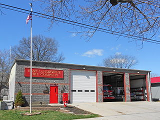
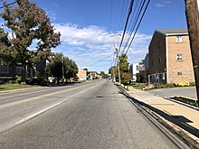
East Lansdowne is a borough in Delaware County, Pennsylvania, United States. The population was 2,668 at the 2010 census. ON February 7, 2024, the East Lansdowne Arson occurred in which a man, Canh Le, shot 2 police officers and killed his 5 family members before setting fire to the house, killing himself. Now, it was confusing because no one knew where Le was. Police at first thought he fled the scene but he was really chasing down everyone inside the house. Le ran away but killed himself in the fire.

<span class="mw-page-title-main">Eddystone, Pennsylvania</span> Borough in Pennsylvania, United States

Eddystone is a borough in Delaware County, Pennsylvania, United States. The population was 2,410 at the 2010 census.

<span class="mw-page-title-main">Folcroft, Pennsylvania</span> Borough in Pennsylvania, United States

Folcroft is a borough in Delaware County, Pennsylvania, United States. The population was 6,606 at the 2010 census, down from 6,978 at the 2000 census.

<span class="mw-page-title-main">Glenolden, Pennsylvania</span> Borough in Pennsylvania, United States

Glenolden is a borough in Delaware County, Pennsylvania, United States. The population was 7,153 at the 2010 census, down from 7,476 at the 2000 census.

<span class="mw-page-title-main">Lansdowne, Pennsylvania</span> Borough in Pennsylvania, United States

Lansdowne is a borough in Delaware County, Pennsylvania, United States, located 6 miles (10 km) southwest of Center City Philadelphia. It was named for the Marquess of Lansdowne. As of the 2010 census, the borough had a population of 10,620.

<span class="mw-page-title-main">Marcus Hook, Pennsylvania</span> Borough in Pennsylvania, United States

Marcus Hook is a borough in Delaware County, Pennsylvania, United States. The population was 2,397 at the 2010 census. The current mayor is Gene Taylor. The borough calls itself "The Cornerstone of Pennsylvania". The 2005 film One Last Thing... was set and partially filmed in Marcus Hook.

<span class="mw-page-title-main">Morton, Pennsylvania</span> Borough in Pennsylvania, United States

Morton is a borough in Delaware County, Pennsylvania, United States. The population was 2,778 at the 2020 census.

<span class="mw-page-title-main">Prospect Park, Pennsylvania</span> Borough in Pennsylvania, United States

Prospect Park is a borough in Delaware County, Pennsylvania, United States. The population was 6,454 at the 2010 census, down from 6,594 at the 2000 census. It originated as a bedroom community of Philadelphia. It is located within 10 miles (16 km) of Center City, Philadelphia, with convenient rail access.

<span class="mw-page-title-main">Ridley Township, Pennsylvania</span> Township in Pennsylvania, United States

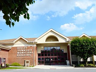
Ridley Township is a township in Delaware County, Pennsylvania, United States. The population was 30,768 at the 2010 census. Ridley Township contains the (CDPs) of Folsom and Woodlyn, along with the unincorporated communities of Crum Lynne and Holmes and a portion of Secane.

<span class="mw-page-title-main">Ridley Park, Pennsylvania</span> Borough in Pennsylvania, United States

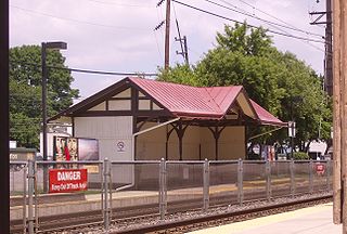
Ridley Park is a borough in Delaware County, Pennsylvania, United States. The population was 7,002 at the 2010 census. Ridley Park is the home of Boeing's CH-47 Chinook helicopter division.

<span class="mw-page-title-main">Sharon Hill, Pennsylvania</span> Borough in Pennsylvania, United States

Sharon Hill is a borough in Delaware County, Pennsylvania, United States. The population was 5,697 at the 2010 census. Currently the population stands at 6,356 residents.

<span class="mw-page-title-main">Springfield Township, Delaware County, Pennsylvania</span> Township in Pennsylvania, United States

Springfield Township, or simply Springfield, is a township in Delaware County in the U.S. state of Pennsylvania. The population was 25,070 at the 2020 census. Springfield is a suburb of Philadelphia, located about 4 miles (6.4 km) west of the city.

<span class="mw-page-title-main">Yeadon, Pennsylvania</span> Borough in Pennsylvania, United States

Yeadon is a borough in Delaware County, Pennsylvania, United States. It borders the city of Philadelphia. The population was 11,443 at the 2010 census.

<span class="mw-page-title-main">Darby Township, Pennsylvania</span> First Class Township in Pennsylvania, United States

Darby Township is a township in Delaware County, Pennsylvania, United States. The population was 9,264 as of the 2010 census. It is home to both residential areas and expansive industrial districts. Darby Township is home to a diverse population and its industrial districts are popular among shipping companies for their proximity to Philadelphia International Airport. It also is known for being made up of two non-contiguous geographical areas, requiring one to pass through at least two neighboring municipalities to make it from one end of Darby Township to the other. Darby Township is a distinct municipality from the nearby and similarly named Darby Borough and Upper Darby Township.

<span class="mw-page-title-main">Muckinipattis Creek</span>

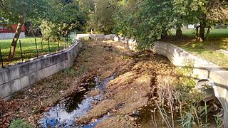
Muckinipattis Creek or Muckinipates Creek is a 5.4-mile-long (8.7 km) creek which runs through Delaware County, Pennsylvania and enters Darby Creek just prior to the Delaware River.

References

  1. "ArcGIS REST Services Directory". United States Census Bureau. Retrieved October 12, 2022.
  2. 1 2 "Census Population API". United States Census Bureau. Retrieved Oct 12, 2022.
  3. 1 2 "Geographic Identifiers: 2010 Demographic Profile Data (G001): Norwood borough, Pennsylvania". U.S. Census Bureau, American Factfinder. Archived from the original on February 13, 2020. Retrieved December 28, 2015.
  4. "Norwood PA Historical Society". www.norwoodpahistorical.org. Retrieved 5 November 2017.
  5. "National Register Information System". National Register of Historic Places . National Park Service. July 9, 2010.
  6. "US Gazetteer files: 2010, 2000, and 1990". United States Census Bureau. 2011-02-12. Retrieved 2011-04-23.
  7. "Census of Population and Housing". U.S. Census Bureau. Retrieved 11 December 2013.
  8. 1 2 "U.S. Census website". United States Census Bureau . Retrieved 2008-01-31.
  9. "Incorporated Places and Minor Civil Divisions Datasets: Subcounty Resident Population Estimates: April 1, 2010 to July 1, 2012". Population Estimates. U.S. Census Bureau. Archived from the original on 11 June 2013. Retrieved 11 December 2013.
  10. "Census 2020".
  11. https://factfinder.census.gov/faces/tableservices/jsf/pages/productview.xhtml?src=CF
  12. "2012 Catholic grade school consolidations/closings". Catholicphilly.com. 2012-07-15. Retrieved 2020-04-22.
  13. "About Us". St. Gabriel Parish School. Archived from the original on 2009-04-03. Retrieved 2020-05-03. - Identified as an official website by the archdiocese here
  14. Crane, Denise (2012-06-12). "LETTER TO THE EDITOR: A St. Gabriel teacher says farewell, thanks". Delco Times . Retrieved 2020-05-03. - Letter to the editor
  15. 1 2 Ormsby, Barbara (2012-05-07). "St. Gabe's memories remain". Delco Times . Retrieved 2020-05-03.
  16. "Season of Change: New regional schools poised to replace long-time Delco Catholic institutions". Delco Times . 2012-06-10. Retrieved 2020-05-03.
  17. "Norwood Borough map" (PDF). PennDOT. Retrieved March 12, 2023.
  18. SEPTA Official Transit & Street Map Suburban (PDF) (Map). SEPTA. Retrieved May 2, 2016.