Sharon Hill, Pennsylvania

Last updated
Sharon Hill, Pennsylvania
Sharon Hill DelCo PA Public Library.jpg
Sharon Hill Public Library
Delaware County Pennsylvania incorporated and unincorporated areas Sharon Hill highlighted.svg
Location in Delaware County and the U.S. state of Pennsylvania.
USA Pennsylvania location map.svg
Red pog.svg
Sharon Hill
Location of Sharon Hill in Pennsylvania
Usa edcp location map.svg
Red pog.svg
Sharon Hill
Sharon Hill (the United States)
Coordinates: 39°54′23″N75°16′16″W / 39.90639°N 75.27111°W / 39.90639; -75.27111
CountryUnited States
StatePennsylvania
County Delaware
Government
  MayorHykeem Green
Area
[1]
  Total0.77 sq mi (2.00 km2)
  Land0.77 sq mi (2.00 km2)
  Water0.00 sq mi (0.00 km2)
Elevation
85 ft (26 m)
Population
 (2010)
  Total5,697
  Estimate 
(2019) [2]
5,689
  Density7,369.17/sq mi (2,846.46/km2)
Time zone UTC-5 (EST)
  Summer (DST) UTC-4 (EDT)
ZIP code
19079
Area code(s) 610 and 484
FIPS code 42-045-69752
FIPS code 42-69752
GNIS feature ID1187371
Website www.sharonhillboro.com

Sharon Hill is a borough in Delaware County, Pennsylvania, United States. The population was 5,697 at the 2010 census. [3] Currently the population stands at 6,356 residents.

Contents

Government

The government of Sharon Hill operates under the Pennsylvania State Borough Code. The day-to-day operations of the borough are exercised through the borough manager, Ieasa Nichols. The mayor is Hykeem Green. The borough has seven councilmembers.[ citation needed ]

Geography

Sharon Hill is located in eastern Delaware County at 39°54′23″N75°16′16″W / 39.90639°N 75.27111°W / 39.90639; -75.27111 (39.906340, -75.271008). [4] It is bordered to the west by Folcroft, to the north by Collingdale and Darby, to the east by Colwyn, and to the south by Darby Township.

According to the United States Census Bureau, Sharon Hill has a total area of 0.77 square miles (2.0 km2), all land. [3]

Demographics

Historical population
CensusPop.Note
1900 1,058
1910 1,40132.4%
1920 1,78027.1%
1930 3,825114.9%
1940 4,46716.8%
1950 5,46422.3%
1960 7,12330.4%
1970 7,4644.8%
1980 6,221−16.7%
1990 5,771−7.2%
2000 5,468−5.3%
2010 5,6974.2%
2020 6,0145.6%
Sources: [5] [6] [7] [8]

2020

Sharon Hill borough, Pennsylvania – Racial and ethnic composition
Note: the US Census treats Hispanic/Latino as an ethnic category. This table excludes Latinos from the racial categories and assigns them to a separate category. Hispanics/Latinos may be of any race.
Race / Ethnicity (NH = Non-Hispanic)Pop 2000 [9] Pop 2010 [10] Pop 2020 [11] % 2000% 20102020
White alone (NH)3,8551,8021,13670.50%31.63%18.89%
Black or African American alone (NH)1,3473,3904,20324.63%59.51%69.89%
Native American or Alaska Native alone (NH)515180.09%0.26%0.30%
Asian alone (NH)831141371.52%2.00%2.28%
Pacific Islander alone (NH)2140.04%0.02%0.07%
Some Other Race alone (NH)115340.20%0.09%0.57%
Mixed Race or Multi-Racial (NH)1071872311.96%3.28%3.84%
Hispanic or Latino (any race)581832511.06%3.21%4.17%
Total5,4685,6976,014100.00%100.00%100.00%

As of Census 2010, the racial makeup of the borough was 32.6% White, 60.6% African American, 0.3% Native American, 2.1% Asian, 0.7% from other races, and 3.7% from two or more races. Hispanic or Latino of any race were 3.2% of the population [ dead link ].

As of the census [6] of 2000, there were 5,697 people, 2,186 households, and 1,390 families residing in the borough. The population density was 7,379.5 inhabitants per square mile (2,849.2/km2). There were 2,265 housing units at an average density of 2,954.0 units per square mile (1,140.5 units/km2). The racial makeup of the borough was 32.6% White, 60.6% African American, 0.3% Native American, 2.1% Asian, 0.00% Pacific Islander, 0.0% from other races, and 3.7% from two or more races. Hispanic or Latino of any race were 3.2% of the population.

There were 2,091 households, out of which 34.0% had children under the age of 18 living with them, 42.7% were married couples living together, 17.4% had a female householder with no husband present, and 33.5% were non-families. 28.7% of all households were made up of individuals, and 10.9% had someone living alone who was 65 years of age or older. The average household size was 2.61 and the average family size was 3.24.

In the borough the population was spread out, with 27.9% under the age of 18, 8.3% from 18 to 24, 31.3% from 25 to 44, 19.9% from 45 to 64, and 12.7% who were 65 years of age or older. The median age was 36 years. For every 100 females there were 89.9 males. For every 100 females age 18 and over, there were 84.3 males.

The median income for a household in the borough was $42,436, and the median income for a family was $48,146. Males had a median income of $37,500 versus $29,049 for females. The per capita income for the borough was $18,503. About 10.6% of families and 11.0% of the population were below the poverty line, including 17.8% of those under age 18 and 3.2% of those age 65 or over.

Education

Students are in the Southeast Delco School District. [12] K-8 school residents in Sharon Hill are zoned to Sharon Hill School. [13] All residents of the school district are zoned to Academy Park High School.

Until 2003, Catholic school students attended Holy Spirit School. This school has since closed due to lack of enrollment. Another Catholic school, Holy Child Academy, closed in 1973.

Delaware County Community College operates the Southeast Center in the Folcroft East Business Park.

Religion

The Roman Catholic Archdiocese of Philadelphia operates Catholic churches. Established in 1892, Holy Spirit Church closed in 2015, consolidating into St. George Church in Glenolden. [14]

Notable people

Transportation

US 13 northbound in Sharon Hill 2022-10-16 14 53 21 View north along U.S. Route 13 (Chester Pike) at Clifton Avenue in Sharon Hill, Delaware County, Pennsylvania.jpg
US 13 northbound in Sharon Hill

As of 2008, there were 11.17 miles (17.98 km) of public roads in Sharon Hill, of which 2.14 miles (3.44 km) were maintained by the Pennsylvania Department of Transportation (PennDOT) and 9.03 miles (14.53 km) were maintained by the borough. [16]

U.S. Route 13 (Chester Pike) is the main road through the borough, leading northeast 8 miles (13 km) to Center City Philadelphia and southwest 6 miles (10 km) to Chester.

SEPTA route 102 streetcar at Sharon Hill station Rt 102 at Sharon Hill.JPG
SEPTA route 102 streetcar at Sharon Hill station

Sharon Hill is connected to the 69th Street Transportation Center in Upper Darby by the SEPTA 102 trolley at its Sharon Hill terminus. Curtis Park Station and Sharon Hill Station are SEPTA train stations on the Wilmington/Newark Regional Rail line.

The new Holy Spirit Catholic Church, built in 1960, closed in 2015 Holy Spirit Parish Sharon Hill PA.jpg
The new Holy Spirit Catholic Church, built in 1960, closed in 2015
Old church near the 1960 Holy Spirit Catholic Church Old Holy Spirit Sharon Hill DelCo PA.jpg
Old church near the 1960 Holy Spirit Catholic Church

Related Research Articles

<span class="mw-page-title-main">Delaware County, Pennsylvania</span> County in Pennsylvania, United States

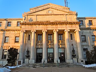
Delaware County, colloquially referred to as Delco, is a county in the Commonwealth of Pennsylvania. With a population of 576,830 as of the 2020 census, it is the fifth-most populous county in Pennsylvania and the third-smallest in area. The county was created on September 26, 1789, from part of Chester County and named for the Delaware River. The county is part of the Southeast Pennsylvania region of the state.

<span class="mw-page-title-main">Aldan, Pennsylvania</span> Borough in Pennsylvania, United States

Aldan is a borough in Delaware County, Pennsylvania, United States. The population was 4,244 at the 2020 census.

<span class="mw-page-title-main">Brookhaven, Pennsylvania</span> Borough in Pennsylvania, United States

Brookhaven is a borough in Delaware County, Pennsylvania, United States. The population was 8,300 at the 2020 census.

<span class="mw-page-title-main">Collingdale, Pennsylvania</span> Borough in Pennsylvania, United States

Collingdale is a borough in Delaware County, Pennsylvania, United States. The population was 8,908 at the 2020 census.

<span class="mw-page-title-main">Colwyn, Pennsylvania</span> Borough in Pennsylvania, United States

Colwyn is a borough in Delaware County, Pennsylvania, United States. The population was 2,546 at the 2010 census.

<span class="mw-page-title-main">East Lansdowne, Pennsylvania</span> Borough in Pennsylvania, United States

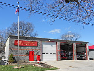
East Lansdowne is a borough in Delaware County, Pennsylvania, United States. The population was 2,668 at the 2010 census.

<span class="mw-page-title-main">Eddystone, Pennsylvania</span> Borough in Pennsylvania, United States

Eddystone is a borough in Delaware County, Pennsylvania, United States. The population was 2,410 at the 2010 census.

<span class="mw-page-title-main">Folcroft, Pennsylvania</span> Borough in Pennsylvania, United States

Folcroft is a borough in Delaware County, Pennsylvania, United States. The population was 6,606 at the 2010 census, down from 6,978 at the 2000 census.

<span class="mw-page-title-main">Glenolden, Pennsylvania</span> Borough in Pennsylvania, United States

Glenolden is a borough in Delaware County, Pennsylvania, United States. The population was 7,153 at the 2010 census, down from 7,476 at the 2000 census.

<span class="mw-page-title-main">Lansdowne, Pennsylvania</span> Borough in Pennsylvania, United States

Lansdowne is a borough in Delaware County, Pennsylvania, United States, located 6 miles (10 km) southwest of Center City Philadelphia. It was named for the Marquess of Lansdowne. As of the 2010 census, the borough had a population of 10,620.

<span class="mw-page-title-main">Lower Chichester Township, Pennsylvania</span> Township in Pennsylvania, United States

Lower Chichester Township is a township in Delaware County, Pennsylvania, United States. The population was 3,469 at the 2010 census. It contains the census designated place of Linwood.

<span class="mw-page-title-main">Marcus Hook, Pennsylvania</span> Borough in Pennsylvania, United States

Marcus Hook is a borough in Delaware County, Pennsylvania, United States. The population was 2,397 at the 2010 census. The current mayor is Gene Taylor. The borough calls itself "The Cornerstone of Pennsylvania". The 2005 film One Last Thing... was set and partially filmed in Marcus Hook.

<span class="mw-page-title-main">Norwood, Pennsylvania</span> Borough in Pennsylvania, United States

Norwood is a borough that is located in Delaware County, Pennsylvania, United States. The population was 5,890 at the time of the 2010 census.

<span class="mw-page-title-main">Parkside, Pennsylvania</span> Borough in Pennsylvania, United States

Parkside is a borough in Delaware County, Pennsylvania, United States. The population was 2,328 at the 2010 census.

<span class="mw-page-title-main">Ridley Township, Pennsylvania</span> Township in Pennsylvania, United States

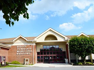
Ridley Township is a township in Delaware County, Pennsylvania, United States. The population was 30,768 at the 2010 census. Ridley Township contains the (CDPs) of Folsom and Woodlyn, along with the unincorporated communities of Crum Lynne and Holmes and a portion of Secane.

<span class="mw-page-title-main">Ridley Park, Pennsylvania</span> Borough in Pennsylvania, United States

Ridley Park is a borough in Delaware County, Pennsylvania, United States. The population was 7,002 at the 2010 census. Ridley Park is the home of Boeing's CH-47 Chinook helicopter division.

<span class="mw-page-title-main">Springfield Township, Delaware County, Pennsylvania</span> Township in Pennsylvania, United States

Springfield Township, or simply Springfield, is a township in Delaware County in the U.S. state of Pennsylvania. The population was 25,070 at the 2020 census. Springfield is a suburb of Philadelphia, located about 4 miles (6.4 km) west of the city.

<span class="mw-page-title-main">Trainer, Pennsylvania</span> Borough in Pennsylvania, United States

Trainer is a borough in Delaware County, Pennsylvania, United States. The population was 1,828 at the 2010 census, down from 1,901 at the 2000 census. The borough was named after David Trainer, a wealthy textile manufacturer.

<span class="mw-page-title-main">Yeadon, Pennsylvania</span> Borough in Pennsylvania, United States

Yeadon is a borough in Delaware County, Pennsylvania, United States. It borders the city of Philadelphia. The population was 11,443 at the 2010 census.

<span class="mw-page-title-main">Darby Township, Pennsylvania</span> First Class Township in Pennsylvania, United States

Darby Township is a township in Delaware County, Pennsylvania, United States. The population was 9,264 as of the 2010 census. It is home to both residential areas and expansive industrial districts. Darby Township is home to a diverse population and its industrial districts are popular among shipping companies for their proximity to Philadelphia International Airport. It also is known for being made up of two non-contiguous geographical areas, requiring one to pass through at least two neighboring municipalities to make it from one end of Darby Township to the other. Darby Township is a distinct municipality from the nearby and similarly named Darby Borough and Upper Darby Township.

References

  1. "2019 U.S. Gazetteer Files". United States Census Bureau. Retrieved July 28, 2020.
  2. "Population and Housing Unit Estimates". United States Census Bureau. May 24, 2020. Retrieved May 27, 2020.
  3. 1 2 "Geographic Identifiers: 2010 Demographic Profile Data (G001): Sharon Hill borough, Pennsylvania". U.S. Census Bureau, American Factfinder. Archived from the original on February 13, 2020. Retrieved December 28, 2015.
  4. "US Gazetteer files: 2010, 2000, and 1990". United States Census Bureau. 2011-02-12. Retrieved 2011-04-23.
  5. "Census of Population and Housing". U.S. Census Bureau. Retrieved 11 December 2013.
  6. 1 2 "U.S. Census website". United States Census Bureau . Retrieved 2008-01-31.
  7. "Incorporated Places and Minor Civil Divisions Datasets: Subcounty Resident Population Estimates: April 1, 2010 to July 1, 2012". Population Estimates. U.S. Census Bureau. Archived from the original on 11 June 2013. Retrieved 11 December 2013.
  8. "Census 2020".
  9. "P004 Hispanic or Latino, and Not Hispanic or Latino by Race – 2000: DEC Summary File 1 – Sharon Hill borough, Pennsylvania". United States Census Bureau .
  10. "P2 Hispanic or Latino, and Not Hispanic or Latino by Race – 2010: DEC Redistricting Data (PL 94-171) – Sharon Hill borough, Pennsylvania". United States Census Bureau .
  11. "P2 Hispanic or Latino, and Not Hispanic or Latino by Race – 2020: DEC Redistricting Data (PL 94-171) – Sharon Hill borough, Pennsylvania". United States Census Bureau .
  12. "2010 CENSUS - CENSUS BLOCK MAP: Sharon Hill borough, PA" (PDF). U.S. Census Bureau . Retrieved 2020-05-04. - Compare to the school district zoning maps.
  13. "District Map". Southeast Delco School District . Retrieved 2020-05-04.
  14. Mengers, Patti (2015-01-12). "Holy Spirit parishioners bid tearful farewell to their church". Delco Times . Retrieved 2020-05-04.
  15. Mengers, Patti (2011-03-13). "Sharon Hill native Cardinal John Foley has retired from his Vatican job and returned to the county". Delco Times . Retrieved 2020-05-04.
  16. "Sharon Hill Borough map" (PDF). PennDOT. Retrieved March 12, 2023.