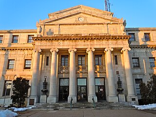
Delaware County, colloquially referred to as Delco, is a county located in the U.S. state of Pennsylvania that borders Philadelphia. With a population of 566,747, it is the fifth most populous county in Pennsylvania, and the third smallest in area. The county was created on September 26, 1789, from part of Chester County, and named for the Delaware River.

Thornbury Township is a township in Chester County, Pennsylvania, United States. The population was 3,017 at the 2010 census. It is adjacent to, and was once joined with, Thornbury Township, Delaware County, Pennsylvania.

Concord Township is a township in Delaware County, Pennsylvania, United States. The population was 17,231 at the 2010 census. It contains the unincorporated communities of Concordville and Glen Mills.

Edgmont Township is a township in Delaware County, Pennsylvania, United States. Edgmont contains the unincorporated community of Gradyville. The population was 3,987 at the 2010 census.
Marple Township is a township in Delaware County, Pennsylvania, United States. It contains the census designated place of Broomall. The population was 23,743 at 2015. ZIP codes include mainly 19008, but also partially 19064 and 19063. The township is run by Marple Township board of commissioners.
Newtown Township is a township in Delaware County, Pennsylvania, United States. Prior to 1789 it was part of Chester County. The population was 12,216 as of the 2010 census, and was 19,705 as of 2017.
Thornbury Township is a township in Delaware County, Pennsylvania, United States. The population was 8,028 at the 2010 census, up from 7,093 at the 2000 census. It is adjacent to, and was once joined with, Thornbury Township, Chester County, Pennsylvania. It contains part of the census designated place of Cheyney University.
Pennsylvania Route 100 is a 59.4-mile (95.6 km) long state highway in the U.S. state of Pennsylvania that runs from U.S. Route 202 near West Chester north to PA 309 in Pleasant Corners. The route runs between the western suburbs of Philadelphia and the Lehigh Valley region of the state, serving Chester, Montgomery, Berks, and Lehigh counties. PA 100 intersects several important highways including US 30 in Exton, the Pennsylvania Turnpike near Lionville, US 422 near Pottstown, US 222 in Trexlertown, and I-78/US 22 in Fogelsville. PA 100 has several sections which are multi-lane divided highway with some interchanges, including between US 202 and the Pennsylvania Turnpike in Chester County, between south of Pottstown and New Berlinville, and between Trexlertown and Fogelsville.
Pennsylvania Route 926 is a 26.2-mile-long (42.2 km) state route located west of Philadelphia in Chester County, Pennsylvania. The western terminus of the route is at PA 10 in Upper Oxford Township. The eastern terminus is at PA 3 in the Philadelphia suburb of Willistown Township. The route is known as Street Road for its entire length. For 0.9 miles (1.4 km), PA 926 runs along the county line between Delaware and Chester Counties. The route passes through a mix of suburban and rural areas along its extent. PA 926 is two lanes and undivided its entire length.
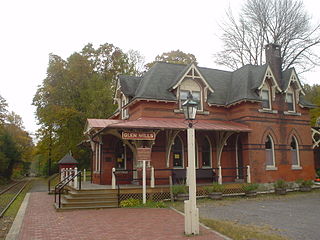
Glen Mills is an unincorporated community in Concord Township, Delaware County, Pennsylvania, United States about 27 miles west of Philadelphia. The ZIP code for Glen Mills is 19342.

Sugartown is an unincorporated settlement in central Willistown Township, Chester County, Pennsylvania, United States, at the intersection of Sugartown and Boot Roads. It is located 18 miles west of Philadelphia.
Pennsylvania Route 112 (PA 112) was a 4+3⁄4-mile-long (7.6 km) state highway located in Delaware and Chester counties in Pennsylvania. Running along current day Cheyney Road, PA 112 began at an intersection with U.S. Route 1 (US 1) in Markham, headed northward, and terminated at an intersection with PA 926 in the community of Tanguy.

Cheyney station is a train station in Thornbury Township, Delaware County, Pennsylvania. It currently serves as a stop on the West Chester Railroad tourist railroad line, and previously served as a station for the Pennsylvania Railroad and SEPTA.

The Amwell Valley is a small valley in Hunterdon County, New Jersey, between the Hunterdon Plateau and the Sourlands. It comprises Stockton, parts of Delaware Township, West Amwell, East Amwell, Flemington and Raritan Township. The region borders the Delaware River to the west and the South Branch Raritan River to the east. The entire area has elevations around two-hundred feet above sea level. US 202 is the main route running west to east through the valley. Old York Road also passes through the valley, taking a generally more southern route through Raritan and along the Sourlands at Mount Airy. Like the Hunterdon Plateau, Amwell Valley still has a large number of farms due to its sufficient climate, relatively flat land and the presence of silt-loams soils. The valley is home to Unionville Winery and Old York Cellars in Ringoes.

The Sourlands is a region in the US state of New Jersey that includes portions of Hunterdon County, Mercer County and Somerset County. It is centered on Sourland Mountain and comprises parts of Lambertville, East Amwell, West Amwell, Hillsborough, Hopewell Boro, Hopewell Township, and Montgomery Township. The region is flanked by the Hopewell Fault to the south and Amwell Valley to the north that runs from Mount Airy to an area just west of Flagtown and a diabase formation running from Lambertville to Mount Airy. The Sourland also include a hilly area towards the southwest called Pleasant Valley, with a number of farms. Although much of the Sourlands is not conducive to farming, Pleasant Valley and the slopes on the surrounding ridges have a number of farms. The slopes of the ridge to the north are also home to Unionville Vineyard.

Mortonville is an unincorporated area and historic hamlet in Chester County, Pennsylvania on the eastern bank of the West Branch Brandywine Creek. It consists of about a half-dozen structures, two of which are on the National Register of Historic Places: the Mortonville Hotel, and the 12.5-foot-long (3.8 m) "Bridge in East Fallowfield Township" which crosses a mill race a few feet east of a larger bridge. The larger bridge, known as the Mortonville Bridge, was also listed on the NRHP until 2010 when it was delisted following a renovation. The two bridges are in East Fallowfield Township, while most other structures are in Newlin Township.

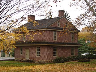
Thornton Village Historic District is a national historic district in Thornbury Township, Delaware County, Pennsylvania. Located in the crossroads village of Thornton at the intersection of Glen Mills and Thornton Roads, the district includes 13 contributing buildings built between 1750 and 1855, some in the Federal style. Among its structures, most of which face Glen Mills Road, are the Yellow House, one commercial building, seven residences, a converted blacksmith shop, a converted barn, three stables or carriage houses, and two frame sheds. Some of the houses are.

Pearsons Corner is an unincorporated community in Kent County, Delaware, United States. Pearsons Corner is located at the intersection of Delaware Route 8 and Delaware Route 44 west of Dover.
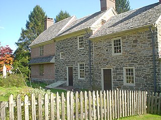
Squire Cheyney Farm is a historic farm and national historic district located in Thornbury Township, Chester County, Pennsylvania. The district encompasses two contributing buildings, three contributing sites, one contributing structure, and contributing object. They are the farmhouse, barn, ruins of a granary, remains of an ice house, a spring house (1799), stone retaining wall, and family cemetery. The house was built in four periods, with the oldest dated to about 1797. The oldest section is a 2 1/s-story, three bay, stuccoed stone structure with a gable roof. The additions were built about 1815, about 1830, and about 1850, making it a seven-bay-wide dwelling. It is "L"-shaped and has a slate gable roof. During the American Revolution, Thomas "Squire" Cheyney [II] informed General George Washington during the Battle of Brandywine that the British were flanking him to the north. He was later appointed to the Pennsylvania Ratifying Convention to ratify the United States Constitution. The site is now a township park known as Squire Cheyney Farm Park.

Chelsea is an unincorporated community in Bethel Township in Delaware County, Pennsylvania, United States. Chelsea is located at the intersection of Concord Road, Chelsea Road, Foulk Road, and Valley Brook Road in the northern part of the township.


