
North Uist is an island and community in the Outer Hebrides of Scotland.

The Inner Hebrides is an archipelago off the west coast of mainland Scotland, to the south east of the Outer Hebrides. Together these two island chains form the Hebrides, which experience a mild oceanic climate. The Inner Hebrides comprise 35 inhabited islands as well as 44 uninhabited islands with an area greater than 30 hectares. Skye, Mull, and Islay are the three largest, and also have the highest populations. The main commercial activities are tourism, crofting, fishing and whisky distilling. In modern times the Inner Hebrides have formed part of two separate local government jurisdictions, one to the north and the other to the south. Together, the islands have an area of about 4,130 km2 (1,594 sq mi), and had a population of 18,948 in 2011. The population density is therefore about 4.6 inhabitants per square kilometre.
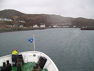
Mallaig is a port in Morar, on the west coast of the Highlands of Scotland. It faces Skye from across the Sound of Sleat. The local railway station is the terminus of the West Highland Line, and the town is linked to Fort William by the A830 road – the "Road to the Isles".

Clan MacLeod is a Highland Scottish clan associated with the Isle of Skye. There are two main branches of the clan: the MacLeods of Harris and Dunvegan, whose chief is MacLeod of MacLeod, are known in Gaelic as Sìol Tormoid ; the Clan MacLeod of Lewis and Raasay, whose chief is MacLeod of The Lewes, are known in Gaelic as Sìol Torcaill. Both branches claim descent from Leòd, who lived in the 13th century.
Sleat is a peninsula and civil parish on the island of Skye in the Highland council area of Scotland, known as "the garden of Skye". It is the home of the clan MacDonald of Sleat. The name comes from the Scottish Gaelic Slèite, which in turn comes from Old Norse sléttr, which well describes Sleat when considered in the surrounding context of the mainland, Skye and Rùm mountains that dominate the horizon all about Sleat.

Trotternish or Tròndairnis is the northernmost peninsula of the Isle of Skye, in Scotland. Its most northerly point, Rubha Hùinis, is the most northerly point of Skye.
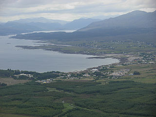
Arisaig is a village in Lochaber, Inverness-shire. It lies 7 miles south of Mallaig on the west coast of the Scottish Highlands, within the Rough Bounds. Arisaig is also the traditional name for part of the surrounding peninsula south of Loch Morar, extending east to Moidart. Etymologically, Arisaig means "safe bay". It lies in the Scottish council area of Highland and has a population of about 300.

Morar is a small village on the west coast of Scotland, 3 miles (5 km) south of Mallaig. The name Morar is also applied to the northern part of the peninsula containing the village, though North Morar is more usual. The coastline of the area forms part of the Morar, Moidart and Ardnamurchan National Scenic Area, one of 40 such areas in Scotland, which are defined so as to identify areas of exceptional scenery and to ensure its protection by restricting certain forms of development.

Duntulm is a township on the most northerly point of the Trotternish peninsula of the Isle of Skye made up of Shulista, south Duntulm and Ghlumaig.

Aird of Sleat is a village on the Isle of Skye in Scotland. It is at the southern end of the Sleat peninsula, 4 miles southeast of Ardvasar and Armadale, at the end of a minor road. Lying 2 miles from Point of Sleat, it is the southernmost settlement on Skye. A track leads from the village to the Point of Sleat Lighthouse.
Broadford, together with nearby Harrapool, is the second-largest settlement on the Isle of Skye, Scotland. Lying in the shadow of the Red Cuillin mountains, Broadford is within the parish of Strath. A long meandering village historically consisting of a few buildings on either side of the Broadford River, the many small townships around the wide sweep of the bay have grown together and Broadford now stretches for 1+1⁄2 miles around the southern side of Broadford Bay.
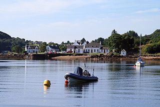
Isleornsay is a village lying off the main Armadale to Sleat road on the Isle of Skye in Scotland. It overlooks, but is not upon, the island of Ornsay. The island itself shelters one of the best natural harbours in southern Skye. The location was exploited from the 18th century or earlier by the MacDonalds who owned this part of Skye.

Tarskavaig is a crofting village on the west coast of Sleat on the Isle of Skye in Scotland. It sits in a glen which meets Tarskavaig Bay and lies opposite the Isles of Eigg, Rum and Canna. It is often said that Tarskavaig has the best view of the Cuillin in Skye.
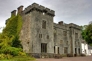
Armadale Castle is a ruined country house in Armadale, Skye, former home of the MacDonalds. A mansion house was first built here around 1790, facing south-east over the Sound of Sleat. In 1815 a square Tudor-Gothic mock-castle, intended for show rather than defence, designed by Edinburgh architect James Gillespie Graham, was built next to the house.

Boreraig is a deserted township in Strath Swordale on the north shore of Loch Eishort in the parish of Strath, Isle of Skye, Scotland.
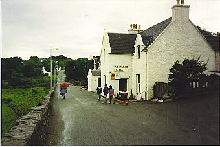
Ardvasar is a village near the southern end of the Sleat peninsula, on the Isle of Skye in Scotland. It is just to the south of the village of Armadale, where a ferry crosses to Mallaig. Nearby attractions include Armadale Castle and the Museum of the Isles.

Teangue is a fishing village on the Sleat peninsula, Isle of Skye, Highlands of Scotland. It is situated in Knock Bay on the west side of the Sound of Sleat. It is in the Scottish council area of Highland.

The Isle of Skye, or simply Skye, is the largest and northernmost of the major islands in the Inner Hebrides of Scotland. The island's peninsulas radiate from a mountainous hub dominated by the Cuillin, the rocky slopes of which provide some of the most dramatic mountain scenery in the country. Although Sgitheanach has been suggested to describe a winged shape, no definitive agreement exists as to the name's origins.
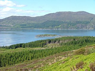
The Sound of Sleat is a narrow sea channel off the western coast of Scotland. It divides the Sleat peninsula on the south-east side of the Isle of Skye from Morar, Knoydart and Glenelg on the Scottish mainland.

Lochalsh is a district of mainland Scotland that is currently part of the Highland council area. The Lochalsh district covers all of the mainland either side of Loch Alsh - and of Loch Duich - between Loch Carron and Loch Hourn, ie. from Stromeferry in the north on Loch Carron down to Corran on Loch Hourn and as (south-)west as Kintail. It was sometimes more narrowly defined as just being the hilly peninsula that lies between Loch Carron and Loch Alsh. The main settlement is Kyle of Lochalsh, located at the entrance to Loch Alsh, opposite the village of Kyleakin on the adjacent island of Skye. A ferry used to connect the two settlements but was replaced by the Skye Bridge in 1995.


