Raasay or the Isle of Raasay is an island between the Isle of Skye and the mainland of Scotland. It is separated from Skye by the Sound of Raasay and from Applecross by the Inner Sound. It is famous for being the birthplace of Gaelic poet Sorley MacLean, an important figure in the Scottish Renaissance.

The A87 is a major road in the Highland region of Scotland.

The Skye Bridge is a road bridge over Loch Alsh, Scotland, connecting the Isle of Skye to the island of Eilean Bàn. The name is also used for the whole Skye Crossing, which further connects Eilean Bàn to the mainland across the Carrich Viaduct. The crossing forms part of the A87.

Glamaig is the northernmost of the Red Hills on the Isle of Skye in Scotland. It lies immediately east of Sligachan. It is one of only two Corbetts on Skye.

Sand on the Applecross Peninsula in Wester Ross, Scotland, is an archaeological site.

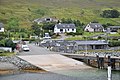
Struan is a small village on the west coast of the island of Skye, on the shores of Loch Beag, itself an inlet of Loch Bracadale. "Struan" is the anglicized form of the Scottish Gaelic word sruthan, meaning "small stream", or the flow at the point where a spring appears.
The Lealt Valley Diatomite Railway was a 2 ft narrow gauge tramway on the Isle of Skye, Scotland, which ran parallel with the River Lealt.

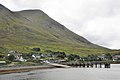
Peinchorran is a remote settlement, lying at the end of the B883 road, on the north east headland of Loch Sligachan on the island of Skye in the Highlands of Scotland. It is in the council area of Highland.

The Isle of Skye, or simply Skye, is the largest and northernmost of the major islands in the Inner Hebrides of Scotland. The island's peninsulas radiate from a mountainous hub dominated by the Cuillin, the rocky slopes of which provide some of the most dramatic mountain scenery in the country. Although Sgitheanach has been suggested to describe a winged shape, no definitive agreement exists as to the name's origins.

Inverness-shire is a historic county, registration county and lieutenancy area of Scotland. Covering much of the Highlands and Outer Hebrides, it is Scotland's largest county, though one of the smallest in population, with 67,733 people or 1.34% of the Scottish population.

MV Loch Bhrusda is a Caledonian Maritime Assets Limited water-jet propulsion ro-ro car ferry operated by Caledonian MacBrayne. After 11 years operating in the Outer Hebrides, she is now a Clyde-based relief small vessel.

Strathaird is a peninsula on the island of Skye, Scotland, situated between Loch Slapin and Loch Scavaig on the south coast.

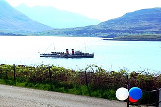
MV Raasay is a bow-loading passenger and vehicle ferry owned by Caledonian Maritime Assets serving Raasay until 2001. She now operates a cargo service to Inishbofin, County Galway from Cleggan.

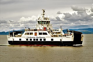
Caledonian Maritime Assets Limited owns the ferries, ports, harbours and infrastructure for the ferry services serving the west coast of Scotland, the Firth of Clyde and the Northern Isles.

MV Glenachulish is a ferry operating a summer service between Glenelg, on the Scottish mainland, and Kylerhea, on the Isle of Skye. Built in 1969, she is the last manually operated steel turntable ferry in the world. The route avoids the 36 mile road journey via the Skye Bridge.

The geology of the Isle of Skye in Scotland is highly varied and the island's landscape reflects changes in the underlying nature of the rocks. A wide range of rock types are exposed on the island, sedimentary, metamorphic and igneous, ranging in age from the Archaean through to the Quaternary.
The Sound of Raasay is the sound between the islands of Raasay and Skye.

Lochalsh is a district of mainland Scotland that is currently part of the Highland council area. The Lochalsh district covers all of the mainland either side of Loch Alsh - and of Loch Duich - between Loch Carron and Loch Hourn, ie. from Stromeferry in the north on Loch Carron down to Corran on Loch Hourn and as (south-)west as Kintail. It was sometimes more narrowly defined as just being the hilly peninsula that lies between Loch Carron and Loch Alsh. The main settlement is Kyle of Lochalsh, located at the entrance to Loch Alsh, opposite the village of Kyleakin on the adjacent island of Skye. A ferry used to connect the two settlements but was replaced by the Skye Bridge in 1995.
MV Catriona is a pioneering diesel electric hybrid passenger and vehicle roll-on, roll-off ferry built for Caledonian MacBrayne for the Claonaig–Lochranza crossing. She is the third hybrid ferry commissioned and owned by Caledonian Maritime Assets, one of three such ferries in the world to incorporate a low-carbon hybrid system of diesel electric and lithium ion battery power. The ferries are sea-going and are nearly 46 metres (150 ft) long, accommodating 150 passengers, 23 cars or two HGVs.
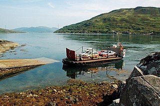
Kyle Rhea is a strait of water in the Highland area of Scotland. It runs from the Inner Seas off the West Coast of Scotland in the southwest to Loch Alsh in the northeast, separating the Isle of Skye from Inverness-shire on the Scottish mainland. It gave its name to Kylerhea, a village on its western shore.