
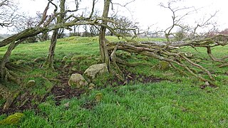
A chambered cairn is a burial monument, usually constructed during the Neolithic, consisting of a sizeable chamber around and over which a cairn of stones was constructed. Some chambered cairns are also passage-graves. They are found throughout Britain and Ireland, with the largest number in Scotland.

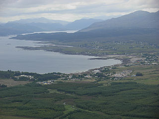
Gairloch is a village, civil parish and community on the shores of Loch Gairloch in Wester Ross, in the North-West Highlands of Scotland. A tourist destination in the summer months, Gairloch has a golf course, a museum, several hotels, a variety of shops, takeaway restaurants, a community centre, a leisure centre with sports facilities, a local radio station, beaches and nearby mountains. Gairloch is one of the principal villages on the North Coast 500 route.

Portree is the largest town on, and capital of, the Isle of Skye in the Inner Hebrides of Scotland. It is the location for the only secondary school on the island, Portree High School. Public transport services are limited to buses. Portree has a harbour, fringed by cliffs, with a pier designed by Thomas Telford.

The A87 is a major road in the Highland region of Scotland.
Calgary is a hamlet on the northwest coast of the Isle of Mull, in Argyll and Bute, Scotland, United Kingdom. The hamlet is within the parish of Kilninian and Kilmore. It was the origin of the name of Fort Calgary in Canada, which became the city of Calgary, Alberta.

Kilmartin Glen is an area in Argyll north of Knapdale. It has the most important concentration of Neolithic and Bronze Age remains in mainland Scotland. The glen is located between Oban and Lochgilphead, surrounding the village of Kilmartin. In the village, Kilmartin Museum explains the stories of this ancient landscape and the people who dwelt there. There are more than 800 ancient monuments within a six-mile (ten-kilometre) radius of the village, with 150 monuments being prehistoric. Monuments include standing stones, a henge monument, numerous cists, and a "linear cemetery" comprising five burial cairns. Several of these, as well as many natural rocks, are decorated with cup and ring marks.

Sollas is a small crofting township on the northern coast of the island of North Uist, Scotland.
Broadford, together with nearby Harrapool, is the second-largest settlement on the Isle of Skye, Scotland. Lying in the shadow of the Red Cuillin mountains, Broadford is within the parish of Strath. A long meandering village historically consisting of a few buildings on either side of the Broadford River, the many small townships around the wide sweep of the bay have grown together and Broadford now stretches for 1+1⁄2 miles around the southern side of Broadford Bay.
Máel Ruba is an Irish saint of the Christian Church who was active in Scotland. Originally from Bangor, County Down, Ireland, he was a monk and founded the monastic community of Applecross in Ross, one of the best attested early Christian monasteries in what is now Scotland. Forms of his name include Máelrubai, Maol Rubha (MoRubha/MaRuibhe), or Malruibhe, and it is sometimes Latinised as Rufus,
Torrin is a settlement on the island of Skye in Scotland.

The Mackinnon Memorial Hospital, also known as Broadford Hospital, is a community hospital, located in the village of Broadford on the Isle of Skye. It is managed by NHS Highland.

Waternish or Vaternish is a peninsula approximately 12 kilometres long on the island of Skye, Scotland, situated between Loch Dunvegan and Loch Snizort in the northwest of the island, and originally inhabited and owned by Clan MacNeacail/MacNicol/Nicolsons.
Timsgarry is a village on the Isle of Lewis, in the Outer Hebrides, Scotland. Timsgarry is home to the Baile na Cille Church and the Uig Museum, noted for its giant Chessmen, discovered in the sands in 1831.
Heasta, Heast, or the anglicised form Heaste, pron. /heɪst/, is a small settlement on the island of Skye, Scotland. It is located on the west coast of the island five miles south of Broadford extending down to the north shore of Loch Eiseort, facing out to the Atlantic to the south west and is in the Scottish council area of Highland.

Isle of Skye (Broadford) Airfield is a small airfield on the Isle of Skye, Scotland, with a single runway. It is next to the hamlet of Ashaig, near the village of Broadford.

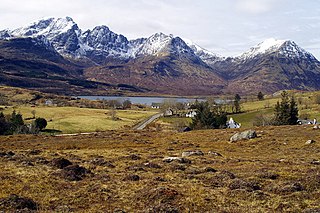
The Isle of Skye, or simply Skye, is the largest and northernmost of the major islands in the Inner Hebrides of Scotland. The island's peninsulas radiate from a mountainous hub dominated by the Cuillin, the rocky slopes of which provide some of the most dramatic mountain scenery in the country. Although Sgitheanach has been suggested to describe a winged shape, no definitive agreement exists as to the name's origins.

Cill Chriosd or Kilchrist is a ruined former parish church of Strath, on the Isle of Skye, Scotland. It was constructed around the 16th century, replacing an earlier medieval church on the same location, and was used until 1840 when the parish church was relocated to Broadford. It lies on the B8083 Broadford to Torrin and Elgol road.

Kilbride is a small township in Strath Swordale, Isle of Skye, Scotland.

The geology of the Isle of Skye in Scotland is highly varied and the island's landscape reflects changes in the underlying nature of the rocks. A wide range of rock types are exposed on the island, sedimentary, metamorphic and igneous, ranging in age from the Archaean through to the Quaternary.
Cairnduff,Cairn Duff or Carn Duff is a roughly circular Bronze Age burial cairn, located on the lands of High Peacockbank Farm near the town of Stewarton in East Ayrshire, Scotland. It was built around 3000 years ago.

