Tarskavaig

Last updated

Tarskavaig
Tarskavaig.jpg
Isle of Skye UK location map.svg
Red pog.svg
Tarskavaig
Location within the Isle of Skye
OS grid reference NG586094
Council area
Country Scotland
Sovereign state United Kingdom
Post town ISLE OF SKYE
Postcode district IV46
Police Scotland
Fire Scottish
Ambulance Scottish
UK Parliament
Scottish Parliament
List of places
UK
Scotland
57°06′45″N5°59′15″W / 57.1126°N 5.98751°W / 57.1126; -5.98751

Tarskavaig (Tarsgabhaig [1] in Scottish Gaelic) is a crofting village on the west coast of Sleat on the Isle of Skye in Scotland. It sits in a glen which meets Tarskavaig Bay and lies opposite the Isles of Eigg, Rum and Canna. It is often said that Tarskavaig has the best view of the Cuillin in Skye.

Contents

Tarskavaig is a traditional crofting village, with a high number of Gaelic speakers, several families with children, and active crofters. It has an SSSI related to the Tarskavaig Moine Thrust, which is located at Achnacloich. The crofting township of Achnacloich or Achadh na Cloiche (Scottish Gaelic: "Stonefield") is located on the outskirts of Tarskavaig by the Gillean Burn watercourse. [2] [3]

History

The small coastal crofting community of Tarskavaig is located within Lord MacDonald's old estate, on the Sleat peninsula of Skye. The first Norwegian settlers arrived on Skye around 875 AD and with inter-marriage a Celtic-Norwegian population was quickly established. The name of the village reflects the long and mixed history of the village, being an Old Norse name, þorskavágr (or þorskavík), modern Norwegian Torskavåg (alternatively Torskavik), which translates as "Cod Bay" in English. This connection between the Vikings and the Gaels can be seen by the inclusion of tarsk as a loan word in Gaelic, from torsk in Norwegian. The recent discovery of a very significant Viking boatyard at Rubha an Dùnain, located only 13 miles (21 kilometres) from this crofting/fishing community, indicates the possibility of a Viking maritime link between the two sites.

Up until the 16th century, the area around Tarskavaig was subject to feuds between the MacLeod and MacDonald clans. However, it was not until the 17th century (Charter of 1617) that the MacDonalds finally established control of the area and the clan chief settled at Armadale.

Tarskavaig first appeared on Lord MacDonald's estate rental records in 1718, but it was not until 1766 that the small farming community appeared on a map. The sale of black cattle, as in other parts of Skye at the time, provided the main source of income to pay the rent. The village of Tarskavaig was developed in 1811 to allow Lord MacDonald to exploit the resources of the sea and the under-utilized, poorer-quality land along the coast. The village was laid out to 31 small crofts, but they were not big enough to support a family from the land alone, so the tenants were forced to earn money from kelping and fishing in order to pay the rent.

The economy of Tarskavaig was dependent on five key activities: the breeding of black cattle for sale, growing potatoes, fishing, kelping, and the rearing of sheep for wool. Tragically, during the course of the 19th century, these vital sources of employment and subsistence successively failed, or declined, leaving the economy of the village in ruins. It was only by finding ever more 'work in the south' that crofting families were able to survive. The 'Year of Destitution' in 1837 was the turning point in the history of Tarskavaig, as the land could no longer support the rising population. After reaching a peak of 250 in 1837, the number of inhabitants declined steadily. The Potato Blight of 1846 (a year after Ireland) was another massive blow to the community, as over 80% of the diet was being provided by the potato, and crofting there entered a period of decline.

Gaelic was very much the natural tongue of the home, work, and church in Sleat during the 19th century, and it remained overwhelmingly Gaelic speaking until the end of the Second World War. Gaelic speakers in the parish of Sleat: 1891, 89.3%; 1901, 89.7%. However, Gaelic was even more widely spoken in Tarskavaig: 1891, 97.6%; 1901, 95.2%. In 1901, around 19% of the population of Tarskavaig could only speak Gaelic. By the time of the 2001 census, 54% of the population of Tarskavaig spoke Gaelic, compared to an average of 31% for Skye.

Regardless of all the improvements in land ownership brought about by the Crofters Holdings (Scotland) Act 1886, traditional crofting continued its decline into the 20th century. Increasingly, the crofters had to derive substantial income from employment outside the village in order to keep the crofts functioning. However, following formation of the Clan Donald Lands Trust in 1971 and creation of the successful Sabhal Mòr Ostaig (Gaelic college) at Kilmore in 1974, there has been a major recovery in the population of the area in recent years.

In 2022, a woman was injured by a stabbing at a property in Tarskavaig during the Skye and Lochalsh attacks. [4]

Nearby settlements

Tarskavaig Bay with The Cuillins Tarskavaig bay.jpg
Tarskavaig Bay with The Cuillins

Achnacloich, Tokavaig and Ord are all situated on or near the minor road that serves Tarskavaig.

Places of interest

Original School - the Society in Scotland for Propagating Christian Knowledge (SSPCK) set up the first school at Tarskavaig in 1815 because of the distance to the parish school at Kilmore. Croft 11 was used for the school, and can still be seen today in the middle of the village with its rusty red tin roof.

Free Church – the abandoned Free Church and Schoolhouse, which sits just outside the village, was paid for and built by the villagers of Tarskavaig around 1860. The old church sits on a small bay just outside the village.

Tarskavaig Community Hall – was built on the hill overlooking the village on the site of the old Church of Scotland.

Old Post Office and Shop – closed in 1975, but the building can still be seen on croft 14, next to the road.

Tarskavaig Point – best sea views, old Free Church, Bull Croft.

Last School - A new school with accommodation for 80 pupils was built in 1876, but it was located over the hill and closer to Tocavaig. The renovated schoolhouse sits in Gauscavaig bay, with a view of the remains of Dunscaith Castle, which was the principal seat of the MacDonald Clan in the 15th century.

The Tarskavaig Moine Thrust SSSI is located in the adjacent crofting township of Achnacloich.

Related Research Articles

<span class="mw-page-title-main">Scottish Highlands</span> Cultural and historical region of Scotland

The Highlands is a historical region of Scotland. Culturally, the Highlands and the Lowlands diverged from the Late Middle Ages into the modern period, when Lowland Scots replaced Scottish Gaelic throughout most of the Lowlands. The term is also used for the area north and west of the Highland Boundary Fault, although the exact boundaries are not clearly defined, particularly to the east. The Great Glen divides the Grampian Mountains to the southeast from the Northwest Highlands. The Scottish Gaelic name of A' Ghàidhealtachd literally means "the place of the Gaels" and traditionally, from a Gaelic-speaking point of view, includes both the Western Isles and the Highlands.

<span class="mw-page-title-main">Outer Hebrides</span> Archipelago and council area off the west coast of mainland Scotland

The Outer Hebrides or Western Isles, sometimes known as the Long Isle/Long Island, is an island chain off the west coast of mainland Scotland. The islands are geographically coextensive with Comhairle nan Eilean Siar, one of the 32 unitary council areas of Scotland. They form part of the archipelago of the Hebrides, separated from the Scottish mainland and from the Inner Hebrides by the waters of the Minch, the Little Minch, and the Sea of the Hebrides. Scottish Gaelic is the predominant spoken language, although in a few areas English speakers form a majority.

<span class="mw-page-title-main">North Uist</span> Island and community in the Outer Hebrides of Scotland

North Uist is an island and community in the Outer Hebrides of Scotland.

<span class="mw-page-title-main">South Uist</span> Island of the Outer Hebrides, Scotland

South Uist is the second-largest island of the Outer Hebrides in Scotland. At the 2011 census, it had a usually resident population of 1,754: a decrease of 64 since 2001. The island, in common with the rest of the Hebrides, is one of the last remaining strongholds of the Gaelic language in Scotland. South Uist's inhabitants are known in Gaelic as Deasaich (Southerners). The population is about 90% Roman Catholic.

<span class="mw-page-title-main">Benbecula</span> Island of the Outer Hebrides, Scotland

Benbecula is an island of the Outer Hebrides in the Atlantic Ocean off the west coast of Scotland. In the 2011 census, it had a resident population of 1,283 with a sizable percentage of Roman Catholics. It is in a zone administered by Comhairle nan Eilean Siar or the Western Isles Council. The island is about 12 kilometres from west to east and a similar distance from north to south. It lies between the islands of North Uist and South Uist and is connected to both by road causeways. Benbecula's main settlement and administrative centre is Balivanich.

<span class="mw-page-title-main">Inner Hebrides</span> Archipelago off the west coast of mainland Scotland

The Inner Hebrides is an archipelago off the west coast of mainland Scotland, to the south east of the Outer Hebrides. Together these two island chains form the Hebrides, which experience a mild oceanic climate. The Inner Hebrides comprise 35 inhabited islands as well as 44 uninhabited islands with an area greater than 30 hectares. Skye, Mull, and Islay are the three largest, and also have the highest populations. The main commercial activities are tourism, crofting, fishing and whisky distilling. In modern times the Inner Hebrides have formed part of two separate local government jurisdictions, one to the north and the other to the south. Together, the islands have an area of about 4,130 km2 (1,594 sq mi), and had a population of 18,948 in 2011. The population density is therefore about 4.6 inhabitants per square kilometre.

<span class="mw-page-title-main">Eigg</span> Island of Scotland

Eigg is one of the Small Isles in the Scottish Inner Hebrides. It lies to the south of the Isle of Skye and to the north of the Ardnamurchan peninsula. Eigg is 9 kilometres long from north to south, and 5 km (3 mi) east to west. With an area of 12 sq mi (31 km2), it is the second-largest of the Small Isles after Rùm. Eigg generates virtually all of its electricity using renewable energy.

<span class="mw-page-title-main">Sleat</span>

Sleat is a peninsula and civil parish on the island of Skye in the Highland council area of Scotland, known as "the garden of Skye". It is the home of the clan MacDonald of Sleat. The name comes from the Scottish Gaelic Slèite, which in turn comes from Old Norse sléttr, which well describes Sleat when considered in the surrounding context of the mainland, Skye and Rùm mountains that dominate the horizon all about Sleat.

Arisaig is a village in Lochaber, Inverness-shire. It lies 7 miles south of Mallaig on the west coast of the Scottish Highlands, within the Rough Bounds. Arisaig is also the traditional name for part of the surrounding peninsula south of Loch Morar, extending east to Moidart. Etymologically, Arisaig means "safe bay". It lies in the Scottish council area of Highland and has a population of about 300.

<span class="mw-page-title-main">Morar</span> Human settlement in Scotland

Morar is a small village on the west coast of Scotland, 3 miles (5 km) south of Mallaig. The name Morar is also applied to the northern part of the peninsula containing the village, though North Morar is more usual. The coastline of the area forms part of the Morar, Moidart and Ardnamurchan National Scenic Area, one of 40 such areas in Scotland, which are defined so as to identify areas of exceptional scenery and to ensure its protection by restricting certain forms of development.

<span class="mw-page-title-main">Crofting</span> Form of land tenure particular to the Scottish Highlands

Crofting is a form of land tenure and small-scale food production particular to the Scottish Highlands, the islands of Scotland, and formerly on the Isle of Man. Within the 19th-century townships, individual crofts were established on the better land, and a large area of poorer-quality hill ground was shared by all the crofters of the township for grazing of their livestock.

<span class="mw-page-title-main">Clan MacNeacail</span>

Clan MacNeacail, sometimes known as Clan MacNicol, is a Scottish clan long associated with the Isle of Skye. Tradition states that, early in its history, the clan held the Isle of Lewis, as well as extensive territory on the north-western mainland. The earliest member of the clan on record is one 14th century John "mak Nakyl", who is recorded amongst Edward I of England's powerful West Highland supporters during the Wars of Scottish Independence. John Barbour's 1375 epic, The Brus, suggests that by 1316, the clan had switched allegiance to Robert I, and made a decisive intervention in the new theatre of Anglo-Scottish conflict in Ireland. The marriage of an heiress to the MacLeods of Lewis brought a severe loss of lands and power in the following generation, forcing the clan chiefs to relocate to the surviving estates on Skye. However, the MacNeacails retained local significant influence: serving, according to tradition, as members of the Council of the Lords of the Isles and as custodians of the cathedral church of the Western Isles at Snizort. In the 17th century, members of the clan began to Anglicise their surname from the Scottish Gaelic MacNeacail to various forms, such as Nicolson. Today the English variants of the Gaelic surname are borne by members of the clan as well as members of unrelated Scottish families, including the Lowland Clan Nicolson.

<span class="mw-page-title-main">Clan MacInnes</span> Scottish clan

Clan MacInnes is a Scottish clan originally from the western highlands of Scotland. The origin of clan is Morvern and Ardgour, Argylshire, with its clan name is thought to have come into existence in the 13th century. The clan's chief and his heirs were then thought to have been assassinated in the mid-14th century meaning that the clan no longer has a clan chief. Clan MacInnes is not associated – in any way – with the Clan Innes which hails from Moray or the Neishes of Perthshire even though Neish is a cognate of the name Angus.

<span class="mw-page-title-main">Croft (land)</span> Small area of agricultural land

A croft is a fenced or enclosed area of land, usually small and arable, and usually, but not always, with a crofter's dwelling thereon. A crofter is one who has tenure and use of the land, typically as a tenant farmer, especially in rural areas.

<span class="mw-page-title-main">Boreraig</span> Human settlement in Scotland

Boreraig is a deserted township in Strath Swordale on the north shore of Loch Eishort in the parish of Strath, Isle of Skye, Scotland.

<span class="mw-page-title-main">Camuscross</span> Human settlement in Scotland

Camuscross is a small crofting township on the Isle of Skye in Scotland.

<span class="mw-page-title-main">Isle of Skye</span> Island of the Inner Hebrides, Scotland

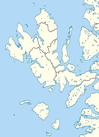
The Isle of Skye, or simply Skye, is the largest and northernmost of the major islands in the Inner Hebrides of Scotland. The island's peninsulas radiate from a mountainous hub dominated by the Cuillin, the rocky slopes of which provide some of the most dramatic mountain scenery in the country. Although Sgitheanach has been suggested to describe a winged shape, no definitive agreement exists as to the name's origins.

<span class="mw-page-title-main">Highland Clearances</span> Eviction of tenants from the Scottish Highlands in the 18th and 19th centuries

The Highland Clearances were the forced evictions of a significant number of tenants in the Scottish Highlands and Islands, mostly in two phases from 1750 to 1860.

<span class="mw-page-title-main">Kilmore, Skye</span> Human settlement in Scotland

Kilmore is a small hamlet, on the east coast of the Sleat peninsula of the Isle of Skye is in the Scottish council area of Highland. It lies on the A851 road and is 14 mile southwest of Ferindonald.

<span class="mw-page-title-main">Lochalsh</span>

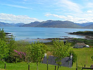
Lochalsh is a district of mainland Scotland that is currently part of the Highland council area. The Lochalsh district covers all of the mainland either side of Loch Alsh - and of Loch Duich - between Loch Carron and Loch Hourn, ie. from Stromeferry in the north on Loch Carron down to Corran on Loch Hourn and as (south-)west as Kintail. It was sometimes more narrowly defined as just being the hilly peninsula that lies between Loch Carron and Loch Alsh. The main settlement is Kyle of Lochalsh, located at the entrance to Loch Alsh, opposite the village of Kyleakin on the adjacent island of Skye. A ferry used to connect the two settlements but was replaced by the Skye Bridge in 1995.

References

  1. Microsoft; Nokia (27 February 2017). "Tarskavaig" (Map). Bing Maps . Microsoft. Retrieved 27 February 2017.
  2. "Achnacloich". ISBuC Places. Isle of Skye Business Community. Retrieved 14 September 2008.
  3. Grid reference NG5877609812
  4. "Man charged with murder and attacks around Skye". BBC News. Retrieved 11 August 2022.
  1. First Statistical Account of Sleat, 1791–99.
  2. An Economical History of the Hebrides and Highlands of Scotland, John Walker, 1808.
  3. Second Statistical Account of Sleat, 1840.
  4. Census Returns Tarskavaig, 1841–1901.
  5. Sir John McNeill's report on the 'Western Highlands and Islands" to the Board of Supervision for the Poor (Scotland), House of Commons, 1851.
  6. Napier Commission Report, 1884.
  7. 'Gàidhlig (Scottish Gaelic) Local Studies – Vol 12, Skye', Kurt C Duwe, 2006. Gaelic speaking statistics.
  8. Clan Donald Library Records and Research.

Commons-logo.svg Media related to Tarskavaig at Wikimedia Commons