Aubrey, Texas

Last updated

Aubrey, Texas
Downtown Aubrey Texas Wiki (1 of 1).jpg
Downtown
Nicknames: 
Horse Country, U.S.A.
Denton County Texas Incorporated Areas Aubrey highlighted.svg
Location of Aubrey in Denton County, Texas
Coordinates: 33°18′26″N96°59′2″W / 33.30722°N 96.98389°W / 33.30722; -96.98389
Country United States
State Texas
County Denton
Area
[1]
  Total3.02 sq mi (7.82 km2)
  Land3.01 sq mi (7.79 km2)
  Water0.01 sq mi (0.03 km2)
Elevation
[2]
676 ft (206 m)
Population
 (2020)
  Total5,006
  Density1,627.33/sq mi (628.24/km2)
Time zone UTC-6 (Central (CST))
  Summer (DST) UTC-5 (CDT)
ZIP code
76227
Area code 940
FIPS code 48-04600 [3]
GNIS feature ID2409753 [2]
Website www.ci.aubrey.tx.us

Aubrey is a city in Denton County, Texas, United States. The population was 5,006 at the 2020 census. [4]

Contents

History

Aubrey, the town, was officially founded in 1867, when Civil War veteran Lemuel Noah Edwards (1838–1910) built the second frame house there. Edwards eventually gave each of his 10 children a lot on which to build a home. The Edwards family was instrumental in several civil developments. Dancing was not allowed, but the townspeople often gathered in the Edwards home for singing and listening to music performed on an organ that Edwards had imported.

In 1881, the Texas and Pacific Railway completed a track and station in Aubrey and commenced operations. [5]

In 1885, Edwards offered a lot to each congregation that would build a church within a year. In 1882 Edwards and Louis Caddel Sr. donated land for a one-room schoolhouse in town. Edwards, through one of his daughters—Edna Mae Edwards (1884–1975), who married Hugh Tobin (1884–1929)—was the grandfather of Louise Tobin, a prolific big band jazz vocalist who attained national acclaim in 1932.

Eventually, Aubrey became known for the peanut farms that surrounded the town. By 2009 horse ranches surrounded Aubrey. Around that time, houses were constructed in Aubrey, replacing the grounds of the old peanut farms. [6]

Geography

Aubrey is located at 33°18′26″N96°59′2″W / 33.30722°N 96.98389°W / 33.30722; -96.98389 (33.307148, –96.983970). [7] It is 12 miles (19 km) north of Denton. [6] According to the United States Census Bureau, the city has a total area of 2.6 square miles (6.8 km2), of which 2.6 square miles (6.7 km2) is land and 0.019 square miles (0.05 km2), or 0.73%, is water. [8]

Demographics

Historical population
CensusPop.Note
1930 439
1940 4727.5%
1950 4914.0%
1960 5348.8%
1970 73136.9%
1980 94829.7%
1990 1,13820.0%
2000 1,50031.8%
2010 2,59573.0%
2020 5,00692.9%
U.S. Decennial Census [9]
Aubrey racial and ethnic composition as of 2020 [4]
(NH = Non-Hispanic) [lower-alpha 1]
RaceNumberPercentage
White (NH)3,27465.4%
Black or African American (NH)4498.97%
Native American or Alaska Native (NH)320.64%
Asian (NH)741.48%
Pacific Islander (NH)30.06%
Some Other Race (NH)120.24%
Mixed/Multi-Racial (NH)2484.95%
Hispanic or Latino 91418.26%
Total5,006

As of the 2020 United States census, there were 5,006 people, 1,721 households, and 1,046 families residing in the city. As of the census [3] of 2000, there were 1,500 people, 559 households, and 418 families residing in the city. The population density was 720.4 inhabitants per square mile (278.1/km2). There were 597 housing units at an average density of 286.7 per square mile (110.7/km2).

In 2000, the racial makeup of the city was 92.5% White, 0.5% African American, 0.7% Native American, 0.5% Asian, 4.7% some other race, and 1.1% from two or more races. Hispanic or Latino of any race were 6.7% of the population. By 2020, the racial and ethnic makeup was 65.4% non-Hispanic white, 8.97% Black or African American, 0.64% Native American, 1.48% Asian, 0.06% Pacific Islander, 0.24% some other race, 4.95% multiracial, and 18.26% Hispanic or Latino of any race. [4]

Education

Aubrey is served by the Aubrey Independent School District. The Aubrey High School mascot is the chaparral (roadrunner). A new intermediate school was completed in 2005 and now houses the middle school as of 2008. A new elementary school was completed and Aubrey Elementary School was renamed Brockett Elementary School in 2008. The old middle school building now houses the district's administration offices.

Braswell High School of the Denton Independent School District is south of Aubrey and serves some areas with "Aubrey, Texas" addresses; they are not in the Aubrey city limits. [11] [12]

Culture

Starr's Service Station, located off Sherman Drive and across the street from the Ever After chapel, previously served as a social center for Aubrey. [6] However, Starr's Service Station was sold and no longer functions as a social center.

Notable person

Notes

  1. Note: the US Census treats Hispanic/Latino as an ethnic category. This table excludes Latinos from the racial categories and assigns them to a separate category. Hispanics/Latinos can be of any race. [10]

Related Research Articles

<span class="mw-page-title-main">Rockwall County, Texas</span> County in Texas, United States

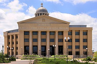
Rockwall County is a county in the U.S. state of Texas. At 149 square miles, Rockwall County has the smallest area of any Texas county. Per the 2020 Census, its population was 107,819. Its county seat is Rockwall. The county and city are named for a wall-like subterranean rock formation that runs throughout the county.

<span class="mw-page-title-main">Kaufman County, Texas</span> County in Texas, United States

Kaufman County is a county in the northeastern area of the U.S. state of Texas. As of the 2020 census, its population was 145,310. Its county seat is Kaufman. Both the county, established in 1848, and the city were named for David S. Kaufman, a U.S. Representative and diplomat from Texas. Kaufman County is part of the Dallas-Fort Worth-Arlington metropolitan statistical area.

<span class="mw-page-title-main">Johnson County, Texas</span> County in Texas, United States

Johnson County is a county located in the U.S. state of Texas. As of the 2020 census, its population was 179,927. Its county seat is Cleburne. Johnson County is named for Colonel Middleton Tate Johnson Sr., a Texas Ranger, politician and soldier in the Mexican-American War and the American Civil War. Johnson County is included in the Dallas–Fort Worth–Arlington metropolitan statistical area.

<span class="mw-page-title-main">Jasper County, Texas</span> County in Texas, United States

Jasper County is a county located in the U.S. state of Texas. As of the 2020 census, its population was 32,980. Its county seat is Jasper. The county was created as a municipality in Mexico in 1834, and in 1837 was organized as a county in the Republic of Texas. It is named for William Jasper, an American Revolutionary War hero.

<span class="mw-page-title-main">Denton County, Texas</span> County in Texas, United States

Denton County is located in the U.S. state of Texas. As of the 2020 census, its population was 906,422, making it the seventh-most populous county in Texas. The county seat is Denton. The county, which was named for John B. Denton, was established in 1846. Denton County constitutes part of the Dallas–Fort Worth metroplex. In 2007, it was one of the fastest-growing counties in the United States.

<span class="mw-page-title-main">Collin County, Texas</span> County in Texas, United States

Collin County is located in the U.S. state of Texas. It is part of the Dallas-Fort Worth-Arlington metropolitan statistical area, and a small portion of the city of Dallas is in the county. At the 2020 United States census, the county's population is 1,064,465, making it the sixth-most populous county in Texas and the 43rd-largest county by population in the United States. Its county seat is McKinney.

<span class="mw-page-title-main">Burleson County, Texas</span> County in Texas, United States

Burleson County is a county located in the U.S. state of Texas. As of the 2020 census, the population was 17,642. Its county seat is Caldwell. The county is named for Edward Burleson, a general and statesman of the Texas Revolution.

<span class="mw-page-title-main">Port Isabel, Texas</span> City in Texas, United States

Port Isabel is a city in Cameron County, Texas, United States. It is part of the Brownsville–Harlingen–Raymondville and the Matamoros–Brownsville metropolitan areas. The population was 5,006 at the 2010 census.

<span class="mw-page-title-main">Prosper, Texas</span> Town in Texas, United States

Prosper is a town in Collin and Denton counties in the U.S. state of Texas. Prosper is located within the Dallas-Fort Worth-Arlington metropolitan area. As of the 2010 census, its population was 9,423; As of 2023, the population was 37,746.

<span class="mw-page-title-main">Weston, Texas</span> City in Texas, United States

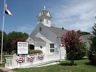
Weston is a city in Collin County, Texas, United States. The population was 563 at the 2010 census, and 283 at the 2020 census.

<span class="mw-page-title-main">Cross Roads, Texas</span> Town in Texas, United States

Cross Roads is a town in Denton County, Texas, United States. The population was 1,744 in 2020.

<span class="mw-page-title-main">Hackberry, Texas</span> Town in Texas, United States

Hackberry is a town in Denton County, Texas, United States. The population was 2,973 in 2020.

<span class="mw-page-title-main">Krugerville, Texas</span> City in Texas, United States

Krugerville is a city in Denton County, Texas, United States. The population was 1,766 in 2020.

<span class="mw-page-title-main">Lincoln Park, Texas</span> Former Town in Texas, United States

Lincoln Park was a town in Denton County, Texas, United States. The population was 308 at the 2010 census.

<span class="mw-page-title-main">Little Elm, Texas</span> City in Texas, United States

Little Elm is a city in Denton County, Texas, United States, and a part of the Dallas–Fort Worth metroplex. It is an extended suburb of Denton; its population was 46,453 as of the 2020 census. In 2000, the census population was at 3,646. By the 2010 census, the city total had jumped to 25,898, making Little Elm one of the fastest-growing municipalities by percentage in Texas since 2000. The July 1, 2022 census estimates Little Elm's population as 55,357.

<span class="mw-page-title-main">Northlake, Texas</span> Town in Texas, United States

Northlake is a town in Denton County, Texas, United States. The population was 5,201 in 2020. The town is located northwest of Grapevine Lake, approximately 10 miles (16 km) northwest of Westlake, Texas.

<span class="mw-page-title-main">Oak Point, Texas</span> City in Texas, United States

Oak Point is a city in Denton County, Texas, United States. Ranked in the Top 20 of 62 suburbs in the Dallas area by D Magazine, Oak Point had a population of 2,786 at the 2010 census.

<span class="mw-page-title-main">Chandler, Texas</span> City in Texas, United States

Chandler is a city in Henderson County, Texas, United States, at the northern end of Lake Palestine. Its population was 3,275 at the 2020 census, up from 2,734 at the 2010 census.

<span class="mw-page-title-main">Balmorhea, Texas</span> City in Texas, United States

Balmorhea is a city in Reeves County, in the U.S. state of Texas. The population was 479 in the U.S. Census of 2010.

<span class="mw-page-title-main">Josephine, Texas</span> City in Texas, United States

Josephine is a city in Collin and Hunt counties in the U.S. state of Texas. Its population was 812 at the 2010 census, with 755 residents in Collin County and 57 in Hunt County. By 2020, its population increased to 2,119.

References

  1. "2019 U.S. Gazetteer Files". United States Census Bureau. Retrieved August 7, 2020.
  2. 1 2 U.S. Geological Survey Geographic Names Information System: Aubrey, Texas
  3. 1 2 "U.S. Census website". United States Census Bureau . Retrieved January 31, 2008.
  4. 1 2 3 "Explore Census Data". data.census.gov. Retrieved May 22, 2022.
  5. Former Teacher Remembers When Aubrey Was Founded, Denton Record-Chronicle, pg. 2, sec 4, July 28, 1963
  6. 1 2 3 Carlisle, Candace. "dcontent/dws/drc/localnews/stories/DRC_Towns_0216.c7b7dbbf.html Small towns disappearing across North Texas prairie [ permanent dead link ]." Denton Record-Chronicle . Friday February 15, 2008. Retrieved on July 26, 2010.
  7. "US Gazetteer files: 2010, 2000, and 1990". United States Census Bureau. February 12, 2011. Retrieved April 23, 2011.
  8. "Geographic Identifiers: 2010 Demographic Profile Data (G001): Aubrey city, Texas". United States Census Bureau . Retrieved June 28, 2012.
  9. "Census of Population and Housing". Census.gov. Retrieved June 4, 2015.
  10. "About the Hispanic Population and its Origin". www.census.gov. Retrieved May 18, 2022.
  11. Home. Braswell High School. Retrieved on December 29, 2016. "Braswell High School,[...]serves families in the eastern portion of the district who reside in[...]"
  12. "Secondary Rezoning Maps and Boundaries." Denton Independent School District. Retrieved on December 30, 2016.