Copper Canyon, Texas

Last updated

Copper Canyon
Denton County Texas Incorporated Areas Copper Canyon highlighted.svg
Location of Copper Canyon in Denton County, Texas
Coordinates: 33°5′56″N97°5′41″W / 33.09889°N 97.09472°W / 33.09889; -97.09472
Country United States
State Texas
County Denton
Area
[1]
  Total4.60 sq mi (11.93 km2)
  Land4.58 sq mi (11.85 km2)
  Water0.03 sq mi (0.07 km2)
Elevation
623 ft (190 m)
Population
 (2020)
  Total1,731
  Density380/sq mi (150/km2)
Time zone UTC-6 (Central (CST))
  Summer (DST) UTC-5 (CDT)
ZIP Code
75077
FIPS code 48-16636 [2]
GNIS feature ID1388576 [3]
Website www.coppercanyon-tx.org

Copper Canyon is a town in Denton County, Texas, United States. The population was 1,731 in 2020. [4] Copper Canyon is adjacent to the master-planned Lantana residential development.

Contents

History

The first European settlement in the area that would become Copper Canyon took place in the 1840s. One of the more prominent settler families was that of Elisha and Mary Chinn, who came to Texas from their original home in North Carolina in 1852. They helped establish the first church in the area, a log-cabin chapel which eventually became known as the Chinn's Chapel Methodist Church. The church is still active on what is now known as Chinn Chapel Road.

The town gradually grew with cattle ranching as the mainstay of the local economy. The railroad came to the area in 1881, and the first public school was constructed in 1884. The town apparently took its name from "Copperhead Canyon," a part of the area formerly known for venomous snakes. Population, never large, generally stagnated or declined in the first half of the twentieth century. After World War II the area's rural charm slowly began to attract residents from the more crowded parts of the Dallas/Fort Worth metroplex.

The town was formally incorporated in 1973. Although still rather sparsely populated, the town has grown as part of the general development of areas north of the Dallas/Fort Worth International Airport. Census Bureau figures tell the story: 465 (1980), 978 (1990), 1,216 (2000), 1,334 (2010). Traditional ranches are still found in the area, but Copper Canyon has become primarily a bedroom community with little commercial development.

Geography

Copper Canyon is located at 33°5′56″N97°5′41″W / 33.09889°N 97.09472°W / 33.09889; -97.09472 (33.098814, –97.094646). [5] According to the United States Census Bureau, the town has a total area of 4.5 square miles (12 km2), of which 4.4 square miles (11 km2) is land and 0.22% is water.

Demographics

Historical population
CensusPop.Note
1980 465
1990 978110.3%
2000 1,21624.3%
2010 1,3349.7%
2020 1,73129.8%
U.S. Decennial Census [6]
Copper Canyon racial composition as of 2020 [4]
(NH = Non-Hispanic) [lower-alpha 1]
RaceNumberPercentage
White (NH)1,43482.84%
Black or African American (NH)211.21%
Native American or Alaska Native (NH)120.69%
Asian (NH)512.95%
Pacific Islander (NH)10.06%
Some Other Race (NH)120.69%
Mixed/Multi-Racial (NH)633.64%
Hispanic or Latino 1377.91%
Total1,731

As of the 2020 United States census, there were 1,731 people, 553 households, and 513 families residing in the town.

Local notes

The Town of Copper Canyon is served by the Lewisville and Denton Independent School Districts.

The town contracts with neighboring communities for most municipal services, such as fire protection from Argyle Fire Department, police services from Denton County Sheriff's Department, and ambulance service from Lewisville. The town boasts of a low tax rate and a number of horse trails maintained for local riders.

Copper Canyon is also home to the Old Alton Bridge, a registered national historic site. Purportedly haunted, it is locally known as the "Goatman's Bridge".

Education

Most of Copper Canyon is in the Lewisville Independent School District, while a portion to the west is in the Denton Independent School District. [8]

Most of Denton ISD Copper Canyon is zoned to Adkins Elementary School, [9] while small parcels are zoned to Blanton Elementary School. [10] All of the Denton ISD part is zoned to Harpool Middle School, [11] and Guyer High School. [12]

Notable person

Notes

  1. Note: the US Census treats Hispanic/Latino as an ethnic category. This table excludes Latinos from the racial categories and assigns them to a separate category. Hispanics/Latinos can be of any race. [7]

Related Research Articles

<span class="mw-page-title-main">Denton County, Texas</span> County in Texas, United States

Denton County is located in the U.S. state of Texas. As of the 2020 census, its population was 906,422, making it the seventh-most populous county in Texas. The county seat is Denton. The county, which was named for John B. Denton, was established in 1846. Denton County constitutes part of the Dallas–Fort Worth metroplex. In 2007, it was one of the fastest-growing counties in the United States.

<span class="mw-page-title-main">Bartonville, Texas</span> Town in Texas, United States

Bartonville is a town in Denton County, Texas, United States. The population was 1,469 at the 2010 census.

<span class="mw-page-title-main">Corinth, Texas</span> City in Texas, United States

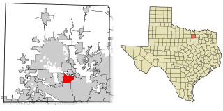
Corinth is a city in Denton County, Texas, United States; it is a part of the Dallas-Fort Worth metroplex. Its population was 22,634 at the 2020 census.

<span class="mw-page-title-main">Cross Roads, Texas</span> Town in Texas, United States

Cross Roads is a town in Denton County, Texas, United States. The population was 1,744 in 2020.

<span class="mw-page-title-main">Double Oak, Texas</span> Town in Texas, United States

Double Oak is a town in Denton County, Texas, United States. The population was 2,867 at the 2010 census.

<span class="mw-page-title-main">Hackberry, Texas</span> Town in Texas, United States

Hackberry is a town in Denton County, Texas, United States. The population was 2,973 in 2020.

<span class="mw-page-title-main">Hickory Creek, Texas</span> Town in Texas, United States

Hickory Creek is a town in Denton County, Texas, United States, located 30 miles (48 km) north of downtown Dallas. The population of Hickory Creek has grown from 219 at its incorporation in 1963 to 3,247 at the 2010 census. It is also one of the four communities in the Lake Cities.

<span class="mw-page-title-main">Highland Village, Texas</span> Enclave city in Texas, United States

Highland Village is a city in Denton County, Texas, United States. It is a suburb of Dallas and Fort Worth, located on the south side of the far western branch of Lewisville Lake. As of the 2020 United States census the city's population was 15,899.

<span class="mw-page-title-main">Lake Dallas, Texas</span> City in Texas, United States

Lake Dallas is a city in Denton County, Texas, United States. It is located in North Texas, northwest of the city of Dallas, on the shores of Lewisville Lake. The community's name derives from the original name of the lake. It is also one of the four communities in the Lake Cities.

<span class="mw-page-title-main">Lakewood Village, Texas</span> City in Texas, United States

Lakewood Village is a city in Denton County, Texas, United States located near Lewisville Lake. The population was estimated to be 706 in 2022

<span class="mw-page-title-main">Lincoln Park, Texas</span> Former Town in Texas, United States

Lincoln Park was a town in Denton County, Texas, United States. The population was 308 at the 2010 census.

<span class="mw-page-title-main">Oak Point, Texas</span> City in Texas, United States

Oak Point is a city in Denton County, Texas, United States. Ranked in the Top 20 of 62 suburbs in the Dallas area by D Magazine, Oak Point had a population of 2,786 at the 2010 census.

<span class="mw-page-title-main">Shady Shores, Texas</span> Town in Texas, United States

Shady Shores is a town in Denton County, Texas, United States. The population was 2,612 at the 2010 census. It is also one of four communities in the Lake Cities.

<span class="mw-page-title-main">Bee Cave, Texas</span> City in Texas, United States

Bee Cave is a city located in Travis County, Texas, United States. Its population was 9,144 as of the 2020 census.

<span class="mw-page-title-main">Carrollton, Texas</span> City in Texas, United States

Carrollton is a city in Dallas, Denton, and Collin counties in the U.S. state of Texas. As of the 2020 census, its population was 133,434, making it the 23rd-most populous city in Texas.

<span class="mw-page-title-main">Denton Independent School District</span> School district in Texas, United States

Denton Independent School District, sometimes shortened to Denton ISD, is a school district based in Denton, Texas. DISD's superintendent is Jamie Wilson.

Savannah is a census-designated place east of Denton in Denton County, Texas, United States. The community is a housing subdivision marketed by Huffines Communities and is located entirely within the boundaries of Denton County Fresh Water Supply District#10. As of the 2010 census, Savannah had a population of 3,318.

Lantana is an upscale census-designated place (CDP) and planned community originally developed by Republic Property Group, 8 miles (13 km) south of Denton in unincorporated Denton County, Texas, United States. The population of the CDP at the 2010 census was 6,874. Lantana had 3,274 occupied homes as of December 31, 2015, with an estimated population of 10,641. Lantana shares the 76226 ZIP code of Argyle. Approximately one quarter of the populace have an annual household income of greater than $150,000, with 34% having incomes from $75,000-$150,000. Almost half of the Lantana population has a bachelor's degree or higher. In 2004, 2006, 2011 and 2012, Lantana won the People's Choice Award for Community of the Year at the Dallas Homebuilders Association McSAM Awards. Lantana hosts regular community events, such as outdoor music presentations in the parks, chili cook offs, festivals, picnics, and other similar functions for its residents.

<span class="mw-page-title-main">Paloma Creek, Texas</span> Master-planned community in Texas, United States

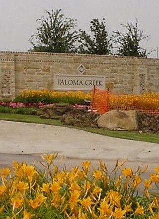
Paloma Creek is a master-planned community in northeastern Denton County, Texas, United States. The community is listed by the U.S. Census Bureau as two separate census-designated places, "Paloma Creek" and "Paloma Creek South", separated by U.S. Highway 380. As of the 2010 census, the Paloma Creek CDP had a population of 2,501, while Paloma Creek South had a population of 2,753. As of 2022, the HOA currently estimates the population to be approximately 20,000.

Paloma Creek South is a census-designated place (CDP) in eastern Denton County, Texas, United States. It is part of the Paloma Creek master-planned community. As of the 2010 census, Paloma Creek South had a population of 2,753.

References

  1. "2019 U.S. Gazetteer Files". United States Census Bureau. Retrieved August 7, 2020.
  2. "U.S. Census website". United States Census Bureau . Retrieved January 31, 2008.
  3. "US Board on Geographic Names". United States Geological Survey. October 25, 2007. Retrieved January 31, 2008.
  4. 1 2 "Explore Census Data". data.census.gov. Retrieved May 22, 2022.
  5. "US Gazetteer files: 2010, 2000, and 1990". United States Census Bureau. February 12, 2011. Retrieved April 23, 2011.
  6. "Census of Population and Housing". Census.gov. Retrieved June 4, 2015.
  7. "About the Hispanic Population and its Origin". www.census.gov. Retrieved May 18, 2022.
  8. "2020 CENSUS - SCHOOL DISTRICT REFERENCE MAP: Denton County, TX" (PDF). U.S. Census Bureau . Retrieved October 3, 2022.
  9. "Adkins Elementary School Attendance Zone" (PDF). Denton Independent School District . Retrieved October 3, 2022.
  10. "Blanton Elementary School Attendance Zone" (PDF). Denton Independent School District . Retrieved October 3, 2022.
  11. "Harpool Middle School Attendance Zone" (PDF). Denton Independent School District . Retrieved October 3, 2022.
  12. "Guyer High School Attendance Zone" (PDF). Denton Independent School District . Retrieved October 3, 2022.
  13. Barone, Michael; Ujifussa, Grant (1999). The Almanac of American Politics 2000 . National Journal Group Inc. p.  1584.