Beaver County, Utah

Last updated

Beaver County
Old Beaver County Ut courthouse.jpg
Map of Utah highlighting Beaver County.svg
Location within the U.S. state of Utah
Utah in United States.svg
Utah's location within the U.S.
Coordinates: 38°20′N113°14′W / 38.34°N 113.23°W / 38.34; -113.23
CountryFlag of the United States.svg United States
StateFlag of Utah.svg  Utah
Founded1856
Named for North American beaver
Seat Beaver
Largest cityBeaver
Area
  Total2,592 sq mi (6,710 km2)
  Land2,590 sq mi (6,700 km2)
  Water2.1 sq mi (5 km2)  0.08%
Population
 (2020)
  Total7,072
  Density2.7/sq mi (1.1/km2)
Time zone UTC−7 (Mountain)
  Summer (DST) UTC−6 (MDT)
Congressional district 2nd
Website beaver.utah.gov

Beaver County is a county in west central Utah, United States. As of the 2020 United States Census, the population was 7,072, [1] up from the 2010 figure of 6,629. [2] Its county seat and largest city is Beaver. [3] The county was named for the abundance of beaver in the area.

Contents

History

Explorers of European descent first visited present-day Beaver County in the 1776 Domínguez-Escalante Expedition. The proposed territory of Deseret (soon changed to Utah Territory) began with the arrival of Mormon pioneers in 1847. After the immediate Great Salt Lake City area was settled, settlers moved into more outlying areas, including the future Beaver County area. The county was created by the Utah territorial legislature from a section of Iron County on January 5, 1856, before the settlement of Beaver town was founded later that year. The county was named for the animal, which was plentiful there. [4] The county boundary as delineated by that act included areas in present-day Colorado and Nevada. The defined boundary was altered on January 16, 1861, by the creation of two counties in present Nevada. The county area was effectively reduced on February 28, 1861, by the US Congress when it created Colorado Territory, taking all of the Beaver County areas east of 109 degrees longitude. The county's boundary was enlarged on January 17, 1861, by the addition of parcels from Millard, Sanpete, and St. Mary's counties. However, its west area was reduced by the creation of the Nevada Territory on July 14, 1862 (this adjustment was altered on May 5, 1866, by the action of the US Congress, effectively ceding all Beaver County area west of 114 degrees longitude to Nevada counties). The county area was also reduced on January 16, 1865, when Piute County was created from Beaver territory. [5]

A quarter of the county's workers are employed by hog processor Smithfield Foods. [6]

Geography

Beaver County (UT) Details Beavercounty ut.png
Beaver County (UT) Details

Beaver County lies on the west side of Utah. Its west border abuts the east border of the state of Nevada. The west part of the county consists of low rolling hills punctuated by isolated mountains. The east edge of the county runs to the crest of a north–south-running mountain ridge. [7] The terrain slopes to the west and north; its highest point is a mountain crest on its east border, at 12,011 ft (3,661 m) ASL. [8] The county has a total area of 2,592 square miles (6,710 km2), of which 2,590 square miles (6,700 km2) is land and 2.1 square miles (5.4 km2) (0.08%) is water. [9]

The Tushar Mountains lies on the eastern boundary of the county, reaching to 12,000 feet (3,700 m) in elevation and providing water for the farming communities of Beaver and Manderfield. To the west, barren desert valleys typify the scenery, separated by mountains lightly forested with junipers. [ citation needed ]

Adjacent counties

Protected areas

[7]

Demographics

Historical population
CensusPop.Note
1860 785
1870 2,007155.7%
1880 3,91895.2%
1890 3,340−14.8%
1900 3,6138.2%
1910 4,71730.6%
1920 5,1398.9%
1930 5,136−0.1%
1940 5,014−2.4%
1950 4,856−3.2%
1960 4,331−10.8%
1970 3,800−12.3%
1980 4,37815.2%
1990 4,7658.8%
2000 6,00526.0%
2010 6,62910.4%
2020 7,0726.7%
US Decennial Census [10]
1790–1960 [11] 1900–1990 [12]
1990–2000 [13] 2010–2018 [2] 2019 [14] 2020 [1]

As of the 2010 United States Census, there were 6,629 people, 2,265 households, and 1,697 families in the county. [15] The population density was 2.56 people per square mile (0.99 people/km2). There were 2,908 housing units at an average density of 1.12 units per square mile (0.43 units/km2). [16] The racial makeup of the county was 89.0% white, 1.1% Asian, 1.1% American Indian, 0.3% Pacific islander, 0.2% black or African American, 6.9% from other races, and 1.4% from two or more races. Those of Hispanic or Latino origin made up 10.8% of the population. [15] In terms of ancestry, 35.2% were English, 15.5% were German, 10.6% were Irish, 6.8% were Scottish, and 2.3% were American. [17]

Of the 2,265 households, 41.8% had children under 18 living with them, 63.2% were married couples living together, 7.2% had a female householder with no husband present, 25.1% were non-families, and 22.1% of all households were made up of individuals. The average household size was 2.92, and the average family size was 3.44. The median age was 31.9 years. [15]

The median income for a household in the county was $41,514, and the median income for a family was $46,426. Males had a median income of $40,167 versus $26,215 for females. The per capita income for the county was $16,131. About 12.6% of families and 17.9% of the population were below the poverty line, including 25.1% of those under age 18 and 15.3% of those age 65 or over. [18]

Politics and government

Beaver County voters have traditionally voted Republican. In no national election since 1964 has the county selected the Democratic Party candidate. Jimmy Carter in 1976 was the last Democrat to even come within ten points of winning Beaver County.

State elected offices
PositionDistrictNameAffiliationFirst elected
  Senate 24 Derrin Owens Republican 2020 [19]
  Senate 28 Evan Vickers Republican 2012 [20]
  House of Representatives 68 Merrill Nelson Republican 2012 [21]
  House of Representatives 73 Phil Lyman Republican 2018 [22]
 Board of Education14Mark HuntsmanNonpartisan2014 [23]
United States presidential election results for Beaver County, Utah [24]
Year Republican Democratic Third party
No.%No.%No.%
2020 2,69586.94%35711.52%481.55%
2016 1,83873.37%26410.54%40316.09%
2012 2,17484.92%34613.52%401.56%
2008 1,90275.54%54221.53%742.94%
2004 2,02379.52%49319.38%281.10%
2000 1,65373.40%54124.02%582.58%
1996 1,16455.59%68732.81%24311.60%
1992 1,04049.27%66831.64%40319.09%
1988 1,28660.89%81638.64%100.47%
1984 1,51667.95%70831.73%70.31%
1980 1,47768.47%62128.79%592.74%
1976 1,08852.41%96346.39%251.20%
1972 1,33264.88%68233.22%391.90%
1968 98950.87%79540.90%1608.23%
1964 79239.98%1,18960.02%00.00%
1960 97145.65%1,15654.35%00.00%
1956 1,19053.60%1,03046.40%00.00%
1952 1,27755.16%1,03844.84%00.00%
1948 1,05746.69%1,19052.56%170.75%
1944 95845.88%1,12854.02%20.10%
1940 1,10145.78%1,30354.18%10.04%
1936 91340.38%1,33759.13%110.49%
1932 96944.03%1,21855.34%140.64%
1928 1,14954.98%93644.78%50.24%
1924 98953.34%57831.18%28715.48%
1920 1,05657.49%74140.34%402.18%
1916 84238.38%1,29158.84%612.78%
1912 67139.75%60235.66%41524.59%
1908 94556.02%71442.32%281.66%
1904 86958.17%59339.69%322.14%
1900 68251.90%62947.87%30.23%
1896 20516.24%1,05783.76%00.00%

Communities

Map of Beaver County municipalities Beaver County Utah incorporated and unincorporated areas.svg
Map of Beaver County municipalities

Cities

Towns

Unincorporated communities

Former communities

Recreation

See also

Related Research Articles

<span class="mw-page-title-main">Box Elder County, Utah</span> County in Utah, United States

Box Elder County is a county at the northwestern corner of Utah, United States. At the 2020 census, the population was 57,666, up from the 2010 figure of 49,975. Its county seat and largest city is Brigham City. The county was named for the box elder trees that abound in the county.

<span class="mw-page-title-main">Duchesne County, Utah</span> County in Utah, United States

Duchesne County is a county in the northeast part of the U.S. state of Utah. As of the 2020 United States Census, the population was 19,596. Its county seat is Duchesne, and the largest city is Roosevelt.

<span class="mw-page-title-main">Garfield County, Utah</span> County in Utah, United States

Garfield County is a county in south central Utah, United States. As of the 2020 United States Census the population was 5,083, making it the fifth-least populous county in Utah; with about one inhabitant per square mile, it is also the least densely populated county in Utah. Its county seat and largest city is Panguitch.

<span class="mw-page-title-main">Iron County, Utah</span> County in Utah, United States

Iron County is a county in southwestern Utah, United States. As of the 2020 United States Census, the population was 57,289. Its county seat is Parowan, and the largest city is Cedar City.

<span class="mw-page-title-main">Juab County, Utah</span> County in Utah, United States

Juab County is a county in western Utah, United States. As of the 2020 United States Census, the population was 11,786. Its county seat and largest city is Nephi.

<span class="mw-page-title-main">Millard County, Utah</span> County in Utah, United States

Millard County is a county in the U.S. state of Utah. As of the 2020 United States Census, the population was 12,975. Its county seat is Fillmore, and the largest city is Delta.

<span class="mw-page-title-main">Piute County, Utah</span> County in Utah, United States

Piute County is a county in south-central Utah, United States. As of the 2020 United States Census, the population was 1,438, making it the second-least populous county in Utah. The county seat is Junction, and the largest town is Circleville.

<span class="mw-page-title-main">Morgan County, Utah</span> County in Utah, United States

Morgan County is a county in northern Utah, United States. As of the 2020 census, the population was 12,295. Its county seat and largest city is Morgan. Morgan County is part of the Ogden-Clearfield, UT Metropolitan Statistical Area as well as the Salt Lake City-Provo-Orem, UT Combined Statistical Area.

<span class="mw-page-title-main">Summit County, Utah</span> County in Utah, United States

Summit County is a county in the U.S. state of Utah, occupying a rugged and mountainous area. As of the 2020 United States Census, the population was 42,357. Its county seat is Coalville, and the largest city is Park City.

<span class="mw-page-title-main">Sanpete County, Utah</span> County in Utah, United States

Sanpete County is a county in the U.S. state of Utah. As of the 2020 United States Census, the population was 28,437. Its county seat is Manti, and its largest city is Ephraim. The county was created in 1850.

<span class="mw-page-title-main">Wasatch County, Utah</span> County in Utah, United States

Wasatch County is a county in the U.S. state of Utah. As of the 2020 United States Census, the population was 34,788. Its county seat and largest city is Heber City. The county was named for a Ute word meaning "mountain pass" or "low place in the high mountains".

<span class="mw-page-title-main">Washington County, Utah</span> County in Utah, United States

Washington County is a county in the southwestern corner of Utah, United States. As of the 2020 United States Census, the population was 180,279, making it the fifth-most populous county in Utah. Its county seat and largest city is St. George. The county was created in 1852 and organized in 1856. It was named after the first President of the United States, George Washington. A portion of the Paiute Indian Reservation is in western Washington County. Washington County comprises the St. George, UT Metropolitan Statistical Area.

<span class="mw-page-title-main">Wayne County, Utah</span> County in Utah, United States

Wayne County is a county in the U.S. state of Utah. As of the 2020 census, the population was 2,486, making it the fourth-least populous county in Utah. Its county seat is Loa.

<span class="mw-page-title-main">Weber County, Utah</span> County in Utah, United States

Weber County is a county in the U.S. state of Utah. As of the 2020 census, the population was 262,223, making it Utah's fourth-most populous county. Its county seat and largest city is Ogden, the home of Weber State University. The county was named after a fur trapper John Weber.

<span class="mw-page-title-main">Lincoln County, Nevada</span> County in Nevada, United States

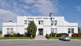
Lincoln County is a county in the U.S. state of Nevada. As of the 2020 census, the population was 4,499, making it the fourth-least populous county in Nevada. Its county seat is Pioche. Like many counties in Nevada, it is dry and sparsely populated, though notable for containing the Area 51 government Air Force base.

<span class="mw-page-title-main">Elko County, Nevada</span> County in Nevada, United States

Elko County is a county in the northeastern corner of Nevada, United States. As of the 2020 census, the population was 53,702. Its county seat is Elko. The county was established on March 5, 1869, from Lander County.

<span class="mw-page-title-main">Minersville, Pennsylvania</span> Borough in Pennsylvania, United States

Minersville is a borough in Schuylkill County, Pennsylvania, United States. Anthracite coal deposits are plentiful in the region. The population was 4,388 at the 2020 census.

<span class="mw-page-title-main">Beaver, Utah</span> City in Utah, United States

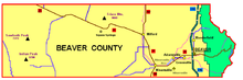
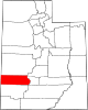
Beaver is a city in, and county seat of, Beaver County in southwestern Utah, United States. The population was 3,592 at the 2020 census, up from the 2010 figure of 3,112.

<span class="mw-page-title-main">Milford, Utah</span> City in Utah, United States

Milford is a city in Beaver County, Utah, United States. The population was 1,431 at the 2020 census, up from the 2010 figure of 1,409.

<span class="mw-page-title-main">Minersville, Utah</span> Town in the state of Utah, United States

Minersville is a town in southeastern Beaver County, Utah, United States. The population was 807 at the 2020 census, down from the 2010 figure of 907.

References

Specific
  1. 1 2 2020 Population and Housing State Data | Utah
  2. 1 2 "State & County QuickFacts". United States Census Bureau. Archived from the original on June 29, 2011. Retrieved December 29, 2013.
  3. "Find a County". National Association of Counties. Archived from the original on July 4, 2012. Retrieved June 7, 2011.
  4. Van Cott, J. W., 1990, Utah Place Names, ISBN   0-87480-345-4
  5. "[[Newberry Library]]. Individual County Chronologies - Beaver County UT (accessed March 25, 2019)". Archived from the original on March 6, 2016. Retrieved March 25, 2019.
  6. "1 in 4 employees in this Utah county work for one company — and it's cutting jobs". The Salt Lake Tribune. Retrieved June 15, 2022.
  7. 1 2 3 4 Beaver County UT Google Maps (accessed 13 March 2019)
  8. ""Find an Altitude/Beaver County UT" Google Maps (accessed March 13, 2019)". Archived from the original on May 21, 2019. Retrieved March 14, 2019.
  9. "2010 Census Gazetteer Files". US Census Bureau. August 22, 2012. Retrieved March 27, 2015.
  10. "US Decennial Census". US Census Bureau. Retrieved March 27, 2015.
  11. "Historical Census Browser". University of Virginia Library. Retrieved March 27, 2015.
  12. Forstall, Richard L., ed. (March 27, 1995). "Population of Counties by Decennial Census: 1900 to 1990". US Census Bureau. Retrieved March 27, 2015.
  13. "Census 2000 PHC-T-4. Ranking Tables for Counties: 1990 and 2000" (PDF). US Census Bureau. April 2, 2001. Retrieved March 27, 2015.
  14. "QuickFacts. Beaver County, Utah" . Retrieved May 17, 2020.
  15. 1 2 3 "Profile of General Population and Housing Characteristics: 2010 Demographic Profile Data". US Census Bureau. Archived from the original on February 13, 2020. Retrieved January 23, 2016.
  16. "Population, Housing Units, Area, and Density: 2010 - County". US Census Bureau. Archived from the original on February 13, 2020. Retrieved January 23, 2016.
  17. "Selected Social Characteristics in the US – 2006-2010 American Community Survey 5-Year Estimate". US Census Bureau. Archived from the original on February 13, 2020. Retrieved January 23, 2016.
  18. "Selected Economic Characteristics – 2006-2010 American Community Survey 5-Year Estimates". US Census Bureau. Archived from the original on February 13, 2020. Retrieved January 23, 2016.
  19. "Senator Owens Utah Senate". senate.utah.gov. Retrieved November 16, 2021.
  20. "Senator Vickers Utah Senate". senate.utah.gov. Retrieved November 15, 2021.
  21. "Rep. Nelson, Merrill F." Utah House of Representatives. Archived from the original on November 15, 2021. Retrieved November 15, 2021.
  22. "Rep. Lyman, Phil". Utah House of Representatives. Archived from the original on November 15, 2021. Retrieved November 15, 2021.
  23. "Mark Huntsman". www.schools.utah.gov. Archived from the original on November 15, 2021. Retrieved November 15, 2021.
  24. Leip, David. "Atlas of US Presidential Elections". uselectionatlas.org. Retrieved March 30, 2018.
General