Utah County, Utah

Last updated

Utah County
East (closer) at Historic Utah County Courthouse, Jul 15.jpg
Historic Utah County Courthouse
Flag of Utah County, Utah.svg
Map of Utah highlighting Utah County.svg
Location within the U.S. state of Utah
Utah in United States.svg
Utah's location within the U.S.
Coordinates: 40°07′N111°40′W / 40.12°N 111.67°W / 40.12; -111.67
CountryFlag of the United States.svg United States
StateFlag of Utah.svg  Utah
FoundedJanuary 31, 1850 (created)
April 18, 1852 (organized)
Named for Ute Tribe
Seat Provo
Largest cityProvo
Area
  Total2,144 sq mi (5,550 km2)
  Land2,003 sq mi (5,190 km2)
  Water141 sq mi (370 km2)  6.6%
Population
 (2020)
  Total659,399
  Density310/sq mi (120/km2)
Time zone UTC−7 (Mountain)
  Summer (DST) UTC−6 (MDT)
Congressional districts 3rd, 4th
Website www.utahcounty.gov

Utah County is the second-most populous county in the U.S. state of Utah. The county seat and largest city is Provo, [1] which is the state's fourth-largest city, and the largest outside of Salt Lake County. As of the 2020 United States Census, the population was 665,665. [2]

Contents

Utah County is one of two counties forming the Provo-Orem metropolitan statistical area, and is part of the larger Salt Lake City-Provo-Orem, UT Combined Statistical Area. In 2020, the center of population of Utah was in Utah County, in the city of Saratoga Springs. [3]

Utah County is one of the fastest-growing counties in the United States, ranking among the top ten counties in numerical growth. [4] Correspondingly, Provo-Orem is among the top eight metropolitan areas by percentage growth in the country. [5]

Utah County is one of seven counties in the United States to have the same name as its state. The other six counties are Arkansas County, Hawaii County, Idaho County, Iowa County, Oklahoma County and New York County (commonly known as Manhattan). [6]

History

The legislature of the State of Deseret created a county on January 31, 1850, [7] to govern the civic affairs of Utah Valley, which by the 1850s was bustling with newly arrived settlers. The county name is derived from the valley name, which is derived from the Spanish name (Yuta) for the Ute Indians. The State of Deseret dissolved soon after (April 5, 1851), but the counties it had set in place continued. There is little record of any official activity conducted by the fledgling county until April 18, 1852, when a full slate of county officials was published, and recordkeeping began. The first courthouse was built in central Provo in 1866–67. It was soon outgrown and was replaced by a second courthouse (1872–73). By the 1920s, this building was also cramped, and the decision was made to erect a combined city-county building, which was completed in 1926. [8]

The county's boundaries were adjusted in 1852, 1854, 1856, 1862, 1880, and 1884. It has retained its present boundary since 1884. [9]

Geography

Mount Timpanogos in the Wasatch Range is visible from much of Utah County. Mt. Timpanogos (2007).jpg
Mount Timpanogos in the Wasatch Range is visible from much of Utah County.
A partial view of Utah Valley seen here from outside of Salem Baled hay in Utah Valley.jpg
A partial view of Utah Valley seen here from outside of Salem

Utah County terrain ranges from stiff mountain ranges in the east (the Wasatch Range), dropping steeply to a large lake-filled valley. Most of the comparatively level ground is dedicated to agriculture or developed uses, while most of the steep terrain is covered with arid-climate forestation. [10] The county generally slopes to the west and north, with its highest point (Mt. Nebo in the southern part of the county), at 11,928 ft (3,636 m) ASL. [11] The county has an area of 2,144 square miles (5,550 km2), of which 2,003 square miles (5,190 km2) is land and 141 square miles (370 km2) (6.6%) is water. [12]

Utah Valley lies at the center of the county, lined by the mountains of the Wasatch Range on the east. Utah Lake occupies a large part of the valley. The elevation ranges from 4,487 feet (1,368 m) above sea level at the lake to 11,928 feet (3,636 m) at the peak of Mount Nebo.

Major highways

Source: [10]

Protected areas

Source: [10]

Lakes

Source: [10]

Demographics

Historical population
CensusPop.Note
1850 2,026
1860 8,248307.1%
1870 12,20348.0%
1880 17,97347.3%
1890 23,76832.2%
1900 32,45636.6%
1910 37,94216.9%
1920 40,7927.5%
1930 49,02120.2%
1940 57,38217.1%
1950 81,91242.7%
1960 106,99130.6%
1970 137,77628.8%
1980 218,10658.3%
1990 263,59020.9%
2000 368,54039.8%
2010 516,56440.2%
2020 659,39927.7%
2023 (est.)719,174 [13] 9.1%
Utah County racial composition
Race or Ethnicity2020 [19] 2010 [20] 2000 [21] 1990 [22] 1950 [23] 1900 [23]
White 81.6%89.4%95.7%96.4%99.6%99.9%
 Non-Hispanic 78.6%84.2%87.7%94.8%n/an/a
Black or African American 0.7%0.5%0.4%0.1%0.02%0.02%
Hispanic or Latino (of any race)13.4%10.8%8.4%3.0%n/an/a
Asian 1.6%1.4%1.2%1.0%n/an/a
Hawaiian & Pacific Islander 1.0%0.8%0.6%0.5%n/an/a
Native American 2.0%1.0%0.6%0.7%n/a0.01%
Multiracial 9.0%2.7%1.4% [1] n/an/an/a

1The 2000 census was the first to allow residents to select multiple race categories. Prior to 2000, the census used the category 'Other Race' as a catch-all identifier. For county-level census data in 1950 and 1900, Utah counted all non-White and non-Black residents using this category. 'Other races' formed 1.4% of Utah County's population in 1990, 0.43% in 1950, and 0.07% in 1900.

2020 census

As of the 2020 United States Census, there were 659,399 people and 171,899 households in the county. The population density was 329.12 people per square mile (127.07 people/km2). There were 192,570 housing units, at an average density of 96.12 units per square mile (37.11 units/km2). The county's racial makeup was 89.4% White, 0.5% Black or African American, 0.6% American Indian or Alaska Native, 1.4% Asian, 0.8% Native Hawaiian or other Pacific Islander, 4.6% some other race, and 2.7% from two or more races. 10.8% of the population were Hispanic or Latino of any race.

There were 140,602 households, out of which 47.7% had children under the age of 18 living with them, 69.9% were headed by married couples living together, 8.0% had a female householder with no husband present, and 18.7% were non-families. Of all households, 11.6% were made up of individuals, and 4.4% were someone living alone who was 65 years of age or older. The average household size was 3.57, and the average family size was 3.88.

The county's population was spread out, with 35.2% under the age of 18, 15.8% from 18 to 24, 28% from 25 to 44, 14.5% from 45 to 64, and 6.5% who were 65 years of age or older. The median age was 24.6 years. For every 100 females, there were 100.3 males. For every 100 females age 18 and over, there were 97.7 males.

At the 2000 census, the median income for a household in the county was $45,833, and the median income for a family was $50,196. Males had a median income of $37,878 versus $22,656 for females. The per capita income for the county was $15,557. About 6.80% of families and 12.00% of the population were below the poverty line, including 8.40% of those under age 18 and 4.80% of those age 65 or over.

Most Reported Ancestries in Utah County (2020) [24]
AncestryPercentage of Population1
Other European-Americans 30.6%
English 28.1%
American or Unclassified22.7%
Other British (including Scottish & Welsh) 10.5%
German 10.5%
Mexican 7.7%
Irish 5%
Other Latin American 4.3%
Middle Eastern or North African 0.3%

1 Due to respondents reporting multiple ethnicities, percentages may add up to greater than 100%.

Religion

Religion in Utah County as of 2020 [25]
ReligionPercent
Latter-day Saints
72%
None
13%
Protestant
9%
Catholic
5%
Other faiths
1%

2000 census

As of the 2000 United States Census, there were 516,564 people, 140,602 households, and 114,350 families in the county. The population density was 258 people per square mile (100 people/km2). There were 148,350 housing units, at an average density of 74.1 units per square mile (28.6 units/km2). The county's racial makeup was 89.4% White, 0.5% Black or African American, 0.6% American Indian or Alaska Native, 1.4% Asian, 0.8% Native Hawaiian or other Pacific Islander, 4.6% some other race, and 2.7% from two or more races. 10.8% of the population were Hispanic or Latino of any race.

There were 140,602 households, out of which 47.7% had children under the age of 18 living with them, 69.9% were headed by married couples living together, 8.0% had a female householder with no husband present, and 18.7% were non-families. Of all households, 11.6% were made up of individuals, and 4.4% were someone living alone who was 65 years of age or older. The average household size was 3.57, and the average family size was 3.88.

The county's population was spread out, with 35.2% under the age of 18, 15.8% from 18 to 24, 28% from 25 to 44, 14.5% from 45 to 64, and 6.5% who were 65 years of age or older. The median age was 24.6 years. For every 100 females, there were 100.3 males. For every 100 females age 18 and over, there were 97.7 males.

At the 2000 census, the median income for a household in the county was $45,833, and the median income for a family was $50,196. Males had a median income of $37,878 versus $22,656 for females. The per capita income for the county was $15,557. About 6.80% of families and 12.00% of the population were below the poverty line, including 8.40% of those under age 18 and 4.80% of those age 65 or over.

In 2005, the five most reported ancestries in Utah County were: [26]

Government

View of the cities of Lehi, American Fork, Pleasant Grove, Lindon and Orem along Interstate 15 and the northeast shore of Utah Lake 2015-11-03 11 16 13 View from an airplane of the cities of Lehi, American Fork, Pleasant Grove, Lindon and Orem, Utah along Interstate 15 and the northeast shore of Utah Lake.jpg
View of the cities of Lehi, American Fork, Pleasant Grove, Lindon and Orem along Interstate 15 and the northeast shore of Utah Lake

The government is a three-member elected county commission elected at-large. Other elected officials include the county sheriff, the county clerk, county recorder, county assessor, county surveyor, county treasurer, and the county attorney. The current county attorney is Jeff Gray.

In 2020, Utah County voters rejected Proposition 9, which would have changed the county's government to a five-member elected county council with an elected county mayor. [27]

The first sheriff of the county was John T. Willis, who was succeeded by William Madison Wall. Alexander Williams served during John Cradlebaugh's court in 1859. He was succeeded by Eli Whipple, who resigned in 1861 and was replaced by Russell Kelly. [28] In 2020, Sheriff Mike Smith publicly stated he would not enforce COVID-19 face mask mandates. [29]

The Utah County Fire Department provides emergency response to all unincorporated areas within Utah County and works with all the incorporated cities within the county plus all Utah state and federal lands. The department is primarily a wildland fires response and urban interspace service with some structure fire and HAZMAT abatement capability. [30]

Politics

United States presidential election results for Utah County, Utah [31]
Year Republican Democratic Third party
No.%No.%No.%
2020 192,81266.69%76,03326.30%20,2567.01%
2016 102,18250.18%28,52214.01%72,93835.82%
2012 156,95088.32%17,2819.72%3,4821.96%
2008 122,22477.71%29,56718.80%5,4883.49%
2004 128,26985.99%17,35711.64%3,5472.38%
2000 98,25581.70%16,44513.67%5,5564.62%
1996 69,65371.05%18,29118.66%10,08710.29%
1992 61,39856.76%14,09013.02%32,69030.22%
1988 68,13477.23%18,53321.01%1,5601.77%
1984 72,28482.61%14,80116.91%4190.48%
1980 71,85983.44%12,16614.13%2,0962.43%
1976 49,32869.48%18,32725.82%3,3384.70%
1972 42,17970.94%10,82818.21%6,45310.85%
1968 29,22659.01%16,62933.57%3,6737.42%
1964 20,91246.63%23,93653.37%00.00%
1960 23,05753.99%19,62645.95%250.06%
1956 25,37166.56%12,74733.44%00.00%
1952 20,91357.71%15,32742.29%00.00%
1948 13,39544.82%16,19154.18%3001.00%
1944 9,94638.68%15,72261.14%450.18%
1940 8,74036.48%15,16863.32%480.20%
1936 6,17329.83%14,38769.52%1350.65%
1932 7,95338.73%12,14059.12%4432.16%
1928 8,77152.19%7,95547.33%810.48%
1924 6,94646.28%5,22634.82%2,83818.91%
1920 7,75253.34%6,37743.88%4032.77%
1916 5,20137.45%8,23559.30%4513.25%
1912 4,18535.45%4,63639.26%2,98625.29%
1908 6,37354.82%4,98442.87%2692.31%
1904 6,49059.15%4,24338.67%2392.18%
1900 5,69850.97%5,39148.22%900.81%
1896 2,03921.66%7,37578.34%00.00%

As the center of Mormon culture, Utah County has been referred to as "the most Republican county in the most Republican state in the United States". [32] It has only voted for a Democratic president nine times since statehood, and has not supported a Democrat for president since 1964.

In the 1992 presidential election, George H. W. Bush received the most votes and Bill Clinton was third in votes received. In the 2004 presidential election, 85.99% voted for George W. Bush. [33] In the 2008 U.S. presidential election, the county voted for John McCain by a 58.9% margin over Barack Obama, compared to McCain winning by 28.1% statewide. [34] Eight other Utah counties voted more strongly in favor of McCain. [35] In the 2012 election, Mitt Romney received 88.32% of the vote. In the 2016 election, it gave a slim majority of the vote to Donald Trump, and nearly 30% of the vote to independent candidate Evan McMullin, who outperformed Hillary Clinton in the county. This was McMullin's largest share of the vote in any county in Utah and his second best nationwide after Madison County, Idaho. In 2020, Joe Biden received over 75,000 votes - the Democrats had never previously received more than 30,000 votes in the county.

Until 2013, Utah County was represented entirely by one congressional district. Currently, the county is split between two congressional districts. Most of the county's population is in the 3rd District, represented by Republican John Curtis, former Provo Mayor. Much of the county's area however, including Utah Lake, resides in the 4th District currently represented by Republican Burgess Owens.

The county's Republican bent runs right through state and local politics. All five state senators representing the county, as well as all 14 state representatives, [36] are Republicans.

State Elected Offices
PositionDistrictNameAffiliationFirst Elected
  Senate 7 Mike McKell Republican 2020 [37]
  Senate 11 Daniel McCay Republican 2018 [38]
  Senate 13 Jake Anderegg Republican 2016 [39]
  Senate 14 Mike Kennedy Republican 2020 [40]
  Senate 15 Keith Grover Republican 2018 [41]
  Senate 16 Curt Bramble Republican 2000 [42]
  Senate 24 Derrin Owens Republican 2020 [43]
  Senate 27 David Hinkins Republican 2008 [44]
  House of Representatives 2 Jefferson Moss Republican 2016 [45]
  House of Representatives 6 Cory Maloy Republican 2016 [46]
  House of Representatives 27 Brady Brammer Republican 2018 [47]
  House of Representatives 48 Keven Stratton Republican 2012 [48]
  House of Representatives 56 Kay Christofferson Republican 2012 [49]
  House of Representatives 57 Jon Hawkins Republican 2018 [50]
  House of Representatives 59 Val Peterson Republican 2010 [51]
  House of Representatives 60 Nelson Abbott Republican 2020 [52]
  House of Representatives 61 Marsha Judkins Republican 2018 [53]
  House of Representatives 63 Adam Robertson Republican 2018 [54]
  House of Representatives 64 Norm Thurston Republican 2014 [55]
  House of Representatives 65Stephen Whyte Republican 2021 [56]
  House of Representatives 66 Jeff Burton Republican 2020 [57]
  House of Representatives 67 Doug Welton Republican 2020 [58]
  House of Representatives 68 Merrill Nelson Republican 2012 [59]
 Board of Education9Cindy DavisNonpartisan2018 [60]
 Board of Education11Natalie Cline Republican 2020 [61]
 Board of Education12James Moss Jr. Republican 2020 [62]
 Board of Education13Randy Boothe Republican 2020 [63]
 Board of Education14Mark HuntsmanNonpartisan2014 [64]

Social issues

Utah County saw high rates of opioid and other prescription drug addiction from the mid-2000s onwards, foreshadowing the national opioid crisis. The 2008 documentary Happy Valley examined the problem. [65]

Giving USA, which reports on charitable giving in the US, named Utah County as one of the three most generous counties in philanthropic donations, alongside San Juan County, Utah and Madison County, Idaho. [66]

In 2019, one in eight people and one in six children in the county did not have sufficient food. [67]

Infrastructure

Much of Utah's transportation infrastructure was built to support automobiles. Prior to the 1950s, Utah County relied on the U.S. Highway System for local transportation. When I-15 was built in 1956 (parallel to Highway 89), it became the dominant transportation vein in the state. The I-15 CORE project added multiple lanes on I-15 through most of Utah County. This expanded 24 miles (39 km) of freeway and was completed in 2012. [68] Other construction projects by UDOT have been done on I-15 since then, including the Technology Corridor project and the Point of the Mountain project. [69] However, the highway system retains its significance in Utah County due to the mountainous terrain. [70] Highway 6 is the closest major road connecting Colorado to the Wasatch Front, running through Spanish Fork Canyon before converging with I-15 in the city of Spanish Fork. Portions of Highway 89 have become prominent local roads known collectively as 'State Street'. Highway 189 is known as 'University Avenue' in the city of Provo, and runs through Provo Canyon into Heber in neighboring Wasatch County.

Utah County has seen significant growth in public transportation over the past 15 years, owing in part to the county's large student population of more than 70,000 commuting to-and-from Brigham Young University (BYU) in Provo and Utah Valley University (UVU) in Orem. The two cities jointly operate UVX, a bus rapid transit system, as part of their city bus routes. Provo also serves as the southernmost terminus of the FrontRunner, Utah's intrastate commuter rail service. [71] The Provo FrontRunner station is located on South University Avenue, directly southwest of Amtrak's Provo Stationwhich is Utah's third westbound stop, after Green River and Helper, for the California Zephyr Amtrak route. In addition to Provo, The FrontRunner currently has three stops in the county. The Orem FrontRunner station is located on the west side of I-15, served by a pedestrian bridge over the freeway that connects the UVU campus directly to the station. An additional stop in Vineyard, Utah was completed in August 2022. [72] Utah County also operates the American Fork FrontRunner Station and the Lehi FrontRunner Station located near Thanksgiving Point. From Lehi, the FrontRunner leaves Utah County and enters Salt Lake County.

Education

School districts

Colleges and universities

Four-year institutions

Two-year institutions

Communities

Map of Utah County CtyMapUtah.png
Map of Utah County
Utah Valley, Utah County as seen from Traverse Ridge in Lehi Utah Valley seen from Traverse Ridge.jpg
Utah Valley, Utah County as seen from Traverse Ridge in Lehi

Cities

Towns

Census-designated places

Unincorporated communities

Former communities

See also

Related Research Articles

<span class="mw-page-title-main">Orem, Utah</span> City in Utah, United States

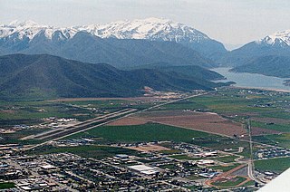
Orem is a city in Utah County, Utah, United States, in the northern part of the state. It is adjacent to Provo, Lindon, and Vineyard and is approximately 45 miles south of Salt Lake City.

<span class="mw-page-title-main">Davis County, Utah</span> County in Utah, United States

Davis County is a county in northern Utah, United States. As of the 2020 United States Census, the population was 362,679, making it Utah's third-most populous county. Its county seat is Farmington, and its largest city by both population and area is Layton.

<span class="mw-page-title-main">Carbon County, Utah</span> County in the United States

Carbon County is a county in the U.S. state of Utah. As of the 2020 United States Census, the population was 20,412. Its county seat and largest city is Price.

<span class="mw-page-title-main">Cache County, Utah</span> County in Utah, United States

Cache County is a county located in the Wasatch Front region of Utah. As of the 2020 United States Census, the population was 133,154, with an estimated 140,173 in 2022. Its county seat and largest city is Logan. Cache County is one of two counties included in the Logan metropolitan area, alongside Franklin County, Idaho.

<span class="mw-page-title-main">Box Elder County, Utah</span> County in Utah, United States

Box Elder County is a county at the northwestern corner of Utah, United States. At the 2020 census, the population was 57,666, up from the 2010 figure of 49,975. Its county seat and largest city is Brigham City. The county was named for the box elder trees that abound in the county.

<span class="mw-page-title-main">Duchesne County, Utah</span> County in Utah, United States

Duchesne County is a county in the northeast part of the U.S. state of Utah. As of the 2020 United States Census, the population was 19,596. Its county seat is Duchesne, and the largest city is Roosevelt.

<span class="mw-page-title-main">Iron County, Utah</span> County in Utah, United States

Iron County is a county in southwestern Utah, United States. As of the 2020 United States Census, the population was 57,289. Its county seat is Parowan, and the largest city is Cedar City.

<span class="mw-page-title-main">Juab County, Utah</span> County in Utah, United States

Juab County is a county in western Utah, United States. As of the 2020 United States Census, the population was 11,786. Its county seat and largest city is Nephi.

<span class="mw-page-title-main">Morgan County, Utah</span> County in Utah, United States

Morgan County is a county in northern Utah, United States. As of the 2020 census, the population was 12,295. Its county seat and largest city is Morgan. Morgan County is part of the Ogden-Clearfield, UT Metropolitan Statistical Area as well as the Salt Lake City-Provo-Orem, UT Combined Statistical Area.

<span class="mw-page-title-main">Salt Lake County, Utah</span> County in Utah, United States

Salt Lake County is located in the U.S. state of Utah. As of the 2020 United States census, the population was 1,185,238, making it the most populous county in Utah. Its county seat and largest city is Salt Lake City, the state capital. The county was created in 1850. Salt Lake County is the 37th most populated county in the United States and is one of four counties in the Rocky Mountains to make it into the top 100. Salt Lake County has been the only county of the first class in Utah – under the Utah Code is a county with a population of 700,000 or greater. Although, Utah County directly to the south has recently reached this threshold.

<span class="mw-page-title-main">Summit County, Utah</span> County in Utah, United States

Summit County is a county in the U.S. state of Utah, occupying a rugged and mountainous area. As of the 2020 United States Census, the population was 42,357. Its county seat is Coalville, and the largest city is Park City.

<span class="mw-page-title-main">Sanpete County, Utah</span> County in Utah, United States

Sanpete County is a county in the U.S. state of Utah. As of the 2020 United States Census, the population was 28,437. Its county seat is Manti, and its largest city is Ephraim. The county was created in 1850.

<span class="mw-page-title-main">Tooele County, Utah</span> County in Utah, United States

Tooele County is a county in the U.S. state of Utah. As of the 2020 United States Census, the population was 72,698. Its county seat and largest city is Tooele. The county was created in 1850 and organized the following year.

<span class="mw-page-title-main">Wasatch County, Utah</span> County in Utah, United States

Wasatch County is a county in the U.S. state of Utah. As of the 2020 United States Census, the population was 34,788. Its county seat and largest city is Heber City. The county was named for a Ute word meaning "mountain pass" or "low place in the high mountains".

<span class="mw-page-title-main">Weber County, Utah</span> County in Utah, United States

Weber County is a county in the U.S. state of Utah. As of the 2020 census, the population was 262,223, making it Utah's fourth-most populous county. Its county seat and largest city is Ogden, the home of Weber State University. The county was named after a fur trapper John Weber.

<span class="mw-page-title-main">Provo, Utah</span> City in Utah, United States

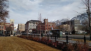
Provo is a city in and the county seat of Utah County, Utah, United States. It is 43 miles (69 km) south of Salt Lake City along the Wasatch Front, and lies between the cities of Orem to the north and Springville to the south. With a population at the 2020 census of 115,162, Provo is the fourth-largest city in Utah and the principal city in the Provo-Orem metropolitan area, which had a population of 526,810 at the 2010 census. It is Utah's second-largest metropolitan area after Salt Lake City.

<span class="mw-page-title-main">Alpine, Utah</span> City in Utah, United States

Alpine is a city on the northeastern edge of Utah County, Utah, United States. The population was 10,251 at the time of the 2020 census. Alpine has been one of the many quickly-growing cities of Utah since the 1970s, especially in the 1990s. This city is thirty-two miles southeast of Salt Lake City. It is located on the slopes of the Wasatch Range north of Highland and American Fork. The west side of the city runs above the Wasatch Fault.

<span class="mw-page-title-main">Heber City, Utah</span> City in Utah, United States

Heber City is a city and county seat of Wasatch County, Utah. The population was 16,856 as of the 2020 United States census. The city is located 43 miles southeast of Salt Lake City.

<span class="mw-page-title-main">Provo–Orem metropolitan area</span> Metropolitan region in Utah, United States

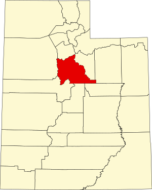
The Provo–Orem, UT Metropolitan Statistical Area, as defined by the United States Office of Management and Budget, is an area consisting of two counties in Utah, anchored by the cities of Provo and Orem. As of the 2020 census, the MSA had a population of 671,185.

<span class="mw-page-title-main">Salt Lake City metropolitan area</span> Metropolitan area in Salt Lake and Tooele counties in Utah, United States

The Salt Lake City metropolitan area is the metropolitan area centered on the city of Salt Lake City, Utah. The Office of Management and Budget and the United States Census Bureau currently define the Salt Lake City, Utah Metropolitan Statistical Area as comprising two counties: Salt Lake and Tooele. As of the 2020 census, the MSA had a population of 1,257,936. The Salt Lake City Metropolitan Area and the Ogden-Clearfield Metropolitan Area were a single metropolitan area known as the Salt Lake City-Ogden Metropolitan Area until being separated in 2005.

References

  1. "Find a County". National Association of Counties. Retrieved June 7, 2011.
  2. 1 2 "State & County QuickFacts". United States Census Bureau . Retrieved December 30, 2013.
  3. "Centers of Population by State: 2020". US Census Bureau. Retrieved June 3, 2024.
  4. "Top 10 Counties in Numeric Growth: July 1, 2020 to July 1, 2021". US Census. Retrieved April 16, 2022.
  5. "Top 10 Metro Areas in Percent Growth: July 1, 2020 to July 1, 2021". US Census. Retrieved April 16, 2022.
  6. Joseph Nathan Kane; Charles Curry Aiken (2005). The American Counties: Origins of County Names, Dates of Creation, and Population Data, 1950-2000. Scarecrow Press. ISBN   978-0-8108-5036-1.
  7. The Utah County website "History" cites January 28, 1850, as the date of establishing Utah County
  8. "Historic Utah County Courthouse" Utah County website (accessed 26 March 2019)
  9. "Utah: Individual County Chronologies". Newberry Library. 2008. Archived from the original on March 6, 2016. Retrieved March 26, 2019.
  10. 1 2 3 4 Utah County UT Google Maps (accessed 26 March 2019)
  11. "Utah County High Points" Peakbagger (accessed 26 March 2019)
  12. "2010 Census Gazetteer Files". US Census Bureau. August 22, 2012. Retrieved June 26, 2015.
  13. "Population and Housing Unit Estimates" . Retrieved June 3, 2024.
  14. "US Decennial Census". US Census Bureau. Retrieved June 3, 2024.
  15. "Historical Census Browser". University of Virginia Library. Retrieved December 30, 2013.
  16. "Population of Counties by Decennial Census: 1900 to 1990". US Census Bureau. Retrieved December 30, 2013.
  17. "Census 2000 PHC-T-4. Ranking Tables for Counties: 1990 and 2000" (PDF). US Census Bureau. Retrieved December 30, 2013.
  18. 2020 Population and Housing State Data | Utah
  19. "Race and Ethnicity in the United States: 2010 Census and 2020 Census". Census.gov. US Census Bureau.
  20. "U.S. Census 2010". United States Census Bureau . Archived from the original on December 27, 1996. Retrieved October 16, 2019.
  21. "Utah County, UT Census Data". infoplease.com.
  22. "1990 Census of Population Social and Economic Characteristics: Utah" (PDF). U.S. Census Bureau.
  23. 1 2 Perlich, Pamela. "Utah Minorities: The Story Told by 150 Years of Census Data" (PDF). Kem C. Gardener Policy Institute.
  24. "American Community Survey: People Reporting Ancestry in Utah County, Utah". US Census Bureau. Retrieved July 3, 2022.
  25. "The 2020 Census of American Religion". Public Religion Research Institute. July 8, 2021. Retrieved July 3, 2022.
  26. "Utah County, Utah, Ancestry & Family History". ePodunk Inc. Archived from the original on April 13, 2010. Retrieved April 13, 2010.
  27. Cleary, Kaela (November 5, 2020). "Utah County voters say 'no' to Prop 9". The Daily Universe. Retrieved December 7, 2020.
  28. "First Sheriffs of Utah County" Tullidge's Quarterly Magazine, Volume 3, 1885, Page 392, accessed at https://www.familysearch.org/photos/artifacts/46400242 on June 7, 2018 (includes list of sheriffs through around 1876).
  29. Mullahy, Brian (September 18, 2020). "Utah County sheriff says if there's a mask mandate, he won't enforce it". KUTV. Retrieved November 13, 2021.
  30. "Utah County Wildland Fire Emergency Response". Archived from the original on August 26, 2015. Retrieved November 13, 2021.
  31. Leip, David. "Atlas of US Presidential Elections". uselectionatlas.org. Retrieved March 31, 2018.
  32. Krakauer, Jon (2003). Under the Banner of Heaven . New York: Doubleday. p.  78. ISBN   9780965778404.
  33. "Utah County General Election, Official Results". UtahCounty.Gov, the Official Website of Utah County Government (http://www.utahcounty.gov). November 2, 2004.
  34. "US Election Atlas". United States Presidential Election Results. David Leip.
  35. "State of Utah County Election Results". NPR. November 21, 2008. Archived from the original on February 18, 2012.
  36. Hesterman, Billy. "Lawmakers say Utah County did well in redistricting process". Daily Herald. Retrieved October 19, 2011.
  37. "Senator McKell Utah Senate". senate.utah.gov. Retrieved November 16, 2021.
  38. "Senator McCay Utah Senate". senate.utah.gov. Retrieved November 16, 2021.
  39. "Senator Anderegg Utah Senate". senate.utah.gov. Retrieved November 16, 2021.
  40. "Senator Kennedy Utah Senate". senate.utah.gov. Retrieved November 16, 2021.
  41. "Senator Grover Utah Senate". senate.utah.gov. Retrieved November 16, 2021.
  42. "Senator Bramble Utah Senate". senate.utah.gov. Retrieved November 16, 2021.
  43. "Senator Owens Utah Senate". senate.utah.gov. Retrieved November 16, 2021.
  44. "Senator Hinkins Utah Senate". senate.utah.gov. Retrieved November 16, 2021.
  45. "Rep. Moss, Jefferson". Utah House of Representatives. Retrieved November 16, 2021.
  46. "Rep. Maloy, A. Cory". Utah House of Representatives. Retrieved November 16, 2021.
  47. "Rep. Brammer, Brady". Utah House of Representatives. Retrieved November 17, 2021.
  48. "Rep. Stratton, Keven J." Utah House of Representatives. Retrieved November 17, 2021.
  49. "Rep. Christofferson, Kay J." Utah House of Representatives. Retrieved November 17, 2021.
  50. "Rep. Hawkins, Jon". Utah House of Representatives. Retrieved November 17, 2021.
  51. "Rep. Peterson, Val L." Utah House of Representatives. Retrieved November 17, 2021.
  52. "Rep. Abbott, Nelson T." Utah House of Representatives. Retrieved November 17, 2021.
  53. "Rep. Judkins, Marsha". Utah House of Representatives. Retrieved November 17, 2021.
  54. "Rep. Robertson, Adam". Utah House of Representatives. Retrieved November 17, 2021.
  55. "Rep. Thurston, Norman K." Utah House of Representatives. Retrieved November 17, 2021.
  56. "Rep. Whyte, Stephen L." Utah House of Representatives. Retrieved November 17, 2021.
  57. "Rep. Burton, Jefferson S." Utah House of Representatives. Retrieved November 17, 2021.
  58. "Rep. Welton, Douglas R." Utah House of Representatives. Retrieved November 17, 2021.
  59. "Rep. Nelson, Merrill F." Utah House of Representatives. Retrieved November 15, 2021.
  60. "Cindy Davis". www.schools.utah.gov. Retrieved November 16, 2021.
  61. "Natalie Cline". www.schools.utah.gov. Retrieved November 16, 2021.
  62. "James Moss Jr". www.schools.utah.gov. Retrieved November 16, 2021.
  63. "Randy Boothe". www.schools.utah.gov. Retrieved November 16, 2021.
  64. "Mark Huntsman". www.schools.utah.gov. Retrieved November 15, 2021.
  65. "Happy Valley (2008)". Amazon. August 12, 2008.
  66. Giving USA 2003 (PDF) (Report). AAFRC Trust for Philanthropy (www.afpnet.org).
  67. Smith, Dave (August 18, 2019). "Community Action: With 13% of the county struggling with hunger, how to host a food drive in Utah". Daily Herald. Retrieved January 14, 2020.
  68. "New changes on I-15 in Utah County". Deseret News . Retrieved October 28, 2011.
  69. "UDOT putting final touches on I-15 Tech Corridor, completing 10-year expansion project". Deseret News . Retrieved June 18, 2022.
  70. "Project: I-15 Reconstruction - Salt Lake City". EconWorks. Retrieved June 18, 2022.
  71. "FrontRunner Rail System Map". Utah Transit Authority. Retrieved June 18, 2022.
  72. "FrontRunner gets a new station—this one in Utah's fastest-growing city". The Salt Lake Tribune. Retrieved June 12, 2023.
  73. "Utah School Districts & Charter Schools" (PDF). Utah State Office of Education. July 25, 2012. Retrieved October 19, 2012.

Further reading