Bennington County, Vermont

Last updated

Bennington County
Bennington county court house manchester vermont 20040731.jpg
Bennington County courthouse in Manchester
Map of Vermont highlighting Bennington County.svg
Location within the U.S. state of Vermont
Vermont in United States.svg
Vermont's location within the U.S.
Coordinates: 43°01′46″N73°06′29″W / 43.029419°N 73.107956°W / 43.029419; -73.107956
CountryFlag of the United States.svg United States
StateFlag of Vermont.svg  Vermont
Founded1778
Named for Benning Wentworth
Shire Town Bennington & Manchester
Largest town Bennington
Area
  Total678 sq mi (1,760 km2)
  Land675 sq mi (1,750 km2)
  Water2.7 sq mi (7 km2)  0.4%
Population
 (2020)
  Total37,347
  Density55/sq mi (21/km2)
Time zone UTC−5 (Eastern)
  Summer (DST) UTC−4 (EDT)
Congressional district At-large
Website www.rpc.bennington.vt.us

Bennington County is a county in the U.S. state of Vermont. As of the 2020 census, the population was 37,347. [1] The shire towns (county seats) are jointly Bennington ("The Southshire") and Manchester ("The Northshire"), [2] and the largest municipality is Bennington. The county was created in 1778. [3]

Contents

History

Bennington is the oldest county in Vermont still in existence, created by the first general assembly on March 17, 1778. [4] Vermont was organized into two original counties, with Bennington in the west and Unity (a few days later renamed Cumberland) in the east. [5] On February 16, 1781 Rutland County was created from Bennington County. [6] On April 13, 1781, Bennington gained the gore east of the town of Bromley (now Peru) from Windham and Windsor Counties. [7]

From June 26, 1781, until February 23, 1782, Vermont attempted to annex part of New York east of the Hudson River (the so-called West Union); inhabitants in the area favored Vermont's township form of government, while Vermont hoped to gain bargaining power through expansion. [8] New York did not lose control of the area. For almost seven months Bennington County overlapped part of Albany County, New York. [9]

On February 27, 1787, Windham County gained the town of Stratton from Bennington County, [10] On October 25, 1805, Rutland County gained from the county when the town of Mount Tabor gained from the town of Peru. [11] The county gained from Rutland County when the town of Dorset gained a small area from the town of Mount Tabor on November 17, 1825. [12]

Geography

According to the U.S. Census Bureau, the county has a total area of 678 square miles (1,760 km2), of which 675 square miles (1,750 km2) is land and 2.7 square miles (7.0 km2) (0.4%) is water. [13]

Adjacent counties

National protected areas

Demographics

Historical population
CensusPop.Note
1790 12,206
1800 14,61719.8%
1810 15,8938.7%
1820 16,1251.5%
1830 17,4688.3%
1840 16,872−3.4%
1850 18,58910.2%
1860 19,4364.6%
1870 21,3259.7%
1880 21,9502.9%
1890 20,448−6.8%
1900 21,7056.1%
1910 21,378−1.5%
1920 21,5770.9%
1930 21,6550.4%
1940 22,2862.9%
1950 24,1158.2%
1960 25,0884.0%
1970 29,28216.7%
1980 33,34513.9%
1990 35,8457.5%
2000 36,9943.2%
2010 37,1250.4%
2020 37,3470.6%
U.S. Decennial Census [14]
1790–1960 [15] 1900–1990 [16]
1990–2000 [17] 2010–2018 [1]

2000 census

As of the census [18] of 2000, there were 36,994 people, 14,846 households, and 9,917 families living in the county. The population density was 55 people per square mile (21 people/km2). There were 19,403 housing units at an average density of 29 units per square mile (11 units/km2). The racial makeup of the county was 97.75% White, 0.42% Black or African American, 0.20% Native American, 0.62% Asian, 0.01% Pacific Islander, 0.21% from other races, and 0.80% from two or more races. 0.93% of the population were Hispanic or Latino of any race. 16.5% were of Irish, 16.0% English, 10.5% French, 9.1% German, 9.0% American, 8.1% Italian and 6.3% French Canadian ancestry. 96.4% spoke English, 1.2% Spanish and 1.2% French as their first language.

There were 14,846 households, out of which 30.50% had children under the age of 18 living with them, 53.10% were married couples living together, 10.10% had a female householder with no husband present, and 33.20% were non-families. 26.80% of all households were made up of individuals, and 11.60% had someone living alone who was 65 years of age or older. The average household size was 2.41 and the average family size was 2.91.

In the county, the population was spread out, with 23.70% under the age of 18, 7.70% from 18 to 24, 26.30% from 25 to 44, 25.70% from 45 to 64, and 16.70% who were 65 years of age or older. The median age was 40 years. For every 100 females there were 92.20 males. For every 100 females age 18 and over, there were 87.90 males.

The median income for a household in the county was $39,926, and the median income for a family was $46,565. Males had a median income of $31,982 versus $23,632 for females. The per capita income for the county was $21,193. About 7.00% of families and 10.00% of the population were below the poverty line, including 13.40% of those under age 18 and 7.90% of those age 65 or over.

2010 census

As of the 2010 United States Census, there were 37,125 people, 15,470 households, and 9,767 families living in the county. [19] The population density was 55.0 inhabitants per square mile (21.2/km2). There were 20,922 housing units at an average density of 31.0 units per square mile (12.0 units/km2). [20] The racial makeup of the county was 96.6% white, 0.8% black, 0.7% Asian, 0.3% American Indian, 0.3% from other races, and 1.3% from two or more races. Those of Hispanic or Latino origin made up 1.4% of the population. [19] The largest ancestry groups were:

[21]

Of the 15,470 households, 27.4% had children under the age of 18 living with them, 48.1% were married couples living together, 10.6% had a female householder with no husband present, 36.9% were non-families, and 29.9% of all households were made up of individuals. The average household size was 2.30 and the average family size was 2.83. The median age was 45.1 years. [19]

The median income for a household in the county was $47,396 and the median income for a family was $60,642. Males had a median income of $40,996 versus $32,068 for females. The per capita income for the county was $27,962. About 8.6% of families and 10.9% of the population were below the poverty line, including 18.1% of those under age 18 and 5.9% of those age 65 or over. [22]

Politics

In 1828, Bennington County voted for National Republican Party candidate John Quincy Adams and for Henry Clay in 1832.

From William Henry Harrison in 1836 to Winfield Scott in 1852, the county would vote for the Whig Party's candidates.

From John C. Frémont in 1856 to Richard Nixon in 1960, the Republican Party would have a 104-year winning streak in the county.

In 1964, the county was won by Democratic Party incumbent President Lyndon B. Johnson, who became not only the first Democratic presidential candidate to win the county, but to win the state of Vermont entirely.

Following the Democrats' victory in 1964, the county went back to voting for Republican candidates for another 20 year winning streak starting with Richard Nixon in 1968 and ending with George H. W. Bush in 1988, who became the last Republican presidential candidate to win the county.

In 1992 the county was won by Bill Clinton and has been won by Democratic candidates ever since.

The county has voted for the statewide winner in forty-seven consecutive elections, tied with neighboring Rutland County, Vermont for the longest such streak in the nation.

United States presidential election results for Bennington County, Vermont [23] [24]
Year Republican Democratic Third party
No.%No.%No.%
2020 7,11434.77%12,70562.09%6433.14%
2016 5,92534.09%9,53954.88%1,91711.03%
2012 5,68732.33%11,51465.45%3922.23%
2008 6,13332.06%12,52465.47%4722.47%
2004 7,61639.95%11,06958.06%3801.99%
2000 7,28441.21%9,02151.03%1,3727.76%
1996 5,22932.37%8,13950.39%2,78417.24%
1992 5,89532.36%8,17844.89%4,14322.74%
1988 8,38753.34%7,17445.62%1641.04%
1984 9,03559.11%6,03939.51%2101.37%
1980 6,09144.39%5,36139.07%2,26916.54%
1976 6,71254.19%5,44343.94%2321.87%
1972 7,54260.56%4,80438.58%1070.86%
1968 5,96752.27%4,96643.50%4834.23%
1964 3,89534.61%7,35965.39%00.00%
1960 7,09961.19%4,50238.80%10.01%
1956 8,43475.59%2,71924.37%40.04%
1952 8,38573.31%3,01826.39%340.30%
1948 5,84062.30%3,34035.63%1942.07%
1944 5,25258.61%3,70941.39%00.00%
1940 5,84557.42%4,30842.32%270.27%
1936 5,51556.08%4,16642.36%1531.56%
1932 5,25055.76%3,96442.10%2022.15%
1928 6,11463.49%3,49836.32%180.19%
1924 5,34172.91%1,46620.01%5187.07%
1920 4,17271.43%1,61527.65%540.92%
1916 2,60260.40%1,59036.91%1162.69%
1912 1,46436.10%1,05726.07%1,53437.83%
1908 2,45373.66%74822.46%1293.87%
1904 2,41974.29%74522.88%922.83%
1900 2,66674.57%87124.36%381.06%
1896 3,08680.39%65617.09%972.53%
1892 2,19664.21%1,15533.77%692.02%
1888 2,49760.72%1,12827.43%48711.84%
1884 2,33562.58%1,36636.61%300.80%
1880 2,64164.71%1,44035.29%00.00%
1876 2,42658.40%1,72841.60%00.00%
1872 2,47172.19%86425.24%882.57%
1868 2,59274.55%88525.45%00.00%
1864 2,32769.44%1,02130.47%30.09%
1860 1,93770.54%71025.86%993.61%
1856 2,12071.26%78526.39%702.35%

Education

Bennington is home to Bennington College. The Community College of Vermont and Vermont Technical College also have campuses in downtown Bennington. Southern Vermont College was located in Bennington, but closed in 2019.

Bennington County is home to these high schools:

Law enforcement

Bennington County is home to these local law enforcement agencies:

The Bennington County Sheriff's Department and Vermont State Police are two other sources of law enforcement for the county, especially in towns without their own local police departments.

Transportation

Major highways

Bus

The main public transportation provider in Bennington County is the Green Mountain Community Network, whose Green Mountain Express bus system has five local bus routes in and around the town of Bennington and three commuter routes to Manchester; Wilmington; Williamstown, Massachusetts; and points in between as of September 29, 2014. Readsboro is served out of Wilmington by Southeast Vermont Transit's (formerly the Deerfield Valley Transit Association) fare free MOOver bus. There are also commuter buses to Rutland from Manchester and a regional bus line to Albany, New York from Bennington via Marble Valley Regional Transit District and Yankee Trails World Travel, respectively. Premier Coach's Vermont Translines (a partner of Greyhound) also stops in Bennington and Manchester on its intercity bus route between Albany and Burlington. The Shires Connector, an Amtrak Thruway intercity bus route also operated by Vermont Translines, also links Manchester and Bennington with Albany, NY's train station in Rensselaer, New York, their Greyhound bus station and airport. [25]

Air

William H. Morse State Airport is a small public-use and state-owned airport west of downtown Bennington, serving private aviation interests. Commercial airlines are available at Albany International Airport to the west in the state of New York, and to the north at Rutland Southern Vermont Regional Airport in Rutland County.

Communities

Downtown Arlington Downtown-arlington-vt.JPG
Downtown Arlington

Towns

Villages

Census-designated places

Other communities

See also

Related Research Articles

<span class="mw-page-title-main">Windsor County, Vermont</span> County in Vermont, United States

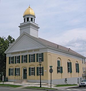
Windsor County is a county located in the U.S. state of Vermont. As of the 2020 census, the population was 57,753. The shire town is the town of Woodstock. The county's largest municipality is the town of Hartford.

<span class="mw-page-title-main">Windham County, Vermont</span> County in Vermont, United States

Windham County is a county located in the U.S. state of Vermont. As of the 2020 census, the population was 45,905. The shire town is Newfane, and the largest municipality is the town of Brattleboro.

<span class="mw-page-title-main">Rutland County, Vermont</span> County in Vermont, United States

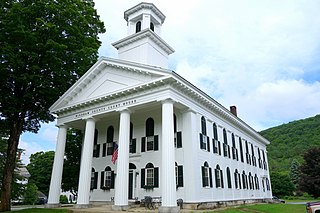
Rutland County is a county located in the U.S. state of Vermont. As of the 2020 census, the population was 60,572, making it the second-most populous county in Vermont. Its county seat and most populous municipality is the city of Rutland.

<span class="mw-page-title-main">Addison County, Vermont</span> County in Vermont, United States

Addison County is a county located in the U.S. state of Vermont. As of the 2020 census, the population was 37,363. Its shire town is the town of Middlebury.

<span class="mw-page-title-main">Dorset, Vermont</span> Town in Vermont, United States

Dorset is a town in Bennington County, Vermont, United States. The population was 2,133 at the 2020 census. Dorset is famous for being the location of Cephas Kent's Inn, where four meetings of the Convention that signed the Dorset Accords led to the independent Vermont Republic and future statehood. Dorset is the site of America's oldest marble quarry and is the birthplace of Bill W., co-founder of Alcoholics Anonymous. East Dorset is the site of the Wilson House and the Griffith Library. The town is named after the English county of Dorset.

<span class="mw-page-title-main">Landgrove, Vermont</span> Town in Vermont, United States

Landgrove is a town in Bennington County, Vermont, United States. The population was 177 at the 2020 census.

<span class="mw-page-title-main">Manchester Center, Vermont</span> Census-designated place in Vermont, United States

Manchester Center is a census-designated place (CDP) in the town of Manchester in Bennington County, Vermont, United States. As of the 2010 census, the CDP had a population of 2,120, out of 4,391 people in the entire town of Manchester.

<span class="mw-page-title-main">North Bennington, Vermont</span> Village in Vermont, United States

North Bennington is an incorporated village in the town of Bennington in Bennington County, Vermont, United States. The population was 1,716 at the 2020 census.

<span class="mw-page-title-main">Readsboro, Vermont</span> Town in Vermont, United States

Readsboro is a town in Bennington County, Vermont, United States. The town was named after John Reade, a landholder. The population was 702 at the 2020 census. The hamlet of Heartwellville is in the northern part of Readsboro, approximately 5 miles (8 km) north on Route 100 from the hamlet of Readsboro.

<span class="mw-page-title-main">Searsburg, Vermont</span> Town in Vermont, United States

Searsburg is a town in Bennington County, Vermont, United States. The population was 126 at the 2020 census.

South Shaftsbury is a census-designated place (CDP) in the town of Shaftsbury in Bennington County, Vermont, United States. The population was 681 at the 2020 census.

<span class="mw-page-title-main">Stamford, Vermont</span> Town in Vermont, United States

Stamford is a town in Bennington County, Vermont, United States. The population was 861 at the 2020 census.

<span class="mw-page-title-main">Sunderland, Vermont</span> Town in Vermont, United States

Sunderland is a town in Bennington County, Vermont, United States. The population was 1,056 at the 2020 census. It is home to the mail-order company Orvis.

<span class="mw-page-title-main">Pawlet, Vermont</span> Town in Vermont, United States

Pawlet is a town in Rutland County, Vermont, United States. The population was 1,424 at the 2020 census.

<span class="mw-page-title-main">White River Junction, Vermont</span> Census-designated place in Vermont, United States

White River Junction is an unincorporated village and census-designated place (CDP) in the town of Hartford in Windsor County, Vermont, United States. The population was 2,528 at the 2020 census, up from 2,286 in 2010, making it the largest community within the town of Hartford.

<span class="mw-page-title-main">Middlebury, Vermont</span> Town in Vermont, United States

Middlebury is the shire town of Addison County, Vermont, United States. As of the 2020 census, the population was 9,152. Middlebury is home to Middlebury College and the Henry Sheldon Museum of Vermont History.

<span class="mw-page-title-main">Bennington, Vermont</span> City in Vermont, United States

Bennington is a town in Bennington County, Vermont, United States. It is one of two shire towns of the county, the other being Manchester. As of the 2020 US Census, the population was 15,333. Bennington is the most populous town in southern Vermont, the second-largest town in Vermont and the sixth-largest municipality in the state.

<span class="mw-page-title-main">Manchester, Vermont</span> Town in Vermont, United States

Manchester is a town in, and one of two shire towns of, Bennington County, Vermont, United States. The population was 4,484 at the 2020 census.

<span class="mw-page-title-main">Wilmington, Vermont</span> Town in Vermont, United States

Wilmington is a town in Windham County, Vermont, United States. The population was 2,255 at the 2020 census.

The Bennington Senate District is one of 16 districts of the Vermont Senate. The current district plan is included in the redistricting and reapportionment plan developed by the Vermont General Assembly following the 2020 U.S. Census, which applies to legislatures elected in 2022, 2024, 2026, 2028, and 2030.

References

  1. 1 2 "State & County QuickFacts". United States Census Bureau. Retrieved October 28, 2021.
  2. "Find a County". National Association of Counties. Archived from the original on May 31, 2011. Retrieved June 7, 2011.
  3. "Vermont: Individual County Chronologies". Vermont Atlas of Historical County Boundaries. The Newberry Library. 2008. Archived from the original on May 10, 2015. Retrieved June 30, 2015.
  4. Vermont History Timeline Archived September 11, 2011, at the Wayback Machine
  5. Vt. State Papers, 12:43–44.
  6. Vermont State Papers, 13:5–6.
  7. Vt. State Papers, 13:19.
  8. Vt. State Papers, 13:45–46; Newton, 83–87; Williamson, C., 101–102.
  9. Vt. State Papers, 3, pt. 2: 67–68.
  10. Vt. State Papers, 14:173–175.
  11. McCarty, "Evolution," 134; Vt. Laws 1805, ch. 15/pp. 19–20.
  12. McCarty, "Evolution," 140; Vt. Laws 1825, no 18/p. 25; Vt. Laws 1832, no. 25/p. 25.
  13. "2010 Census Gazetteer Files". United States Census Bureau. August 22, 2012. Retrieved June 28, 2015.
  14. "U.S. Decennial Census". United States Census Bureau. Retrieved June 28, 2015.
  15. "Historical Census Browser". University of Virginia Library. Retrieved June 28, 2015.
  16. Forstall, Richard L., ed. (March 27, 1995). "Population of Counties by Decennial Census: 1900 to 1990". United States Census Bureau. Retrieved June 28, 2015.
  17. "Census 2000 PHC-T-4. Ranking Tables for Counties: 1990 and 2000" (PDF). United States Census Bureau. April 2, 2001. Archived (PDF) from the original on October 9, 2022. Retrieved June 28, 2015.
  18. "U.S. Census website". United States Census Bureau . Retrieved May 14, 2011.
  19. 1 2 3 "DP-1 Profile of General Population and Housing Characteristics: 2010 Demographic Profile Data". United States Census Bureau. Archived from the original on February 13, 2020. Retrieved January 20, 2016.
  20. "Population, Housing Units, Area, and Density: 2010 - County". United States Census Bureau. Archived from the original on February 13, 2020. Retrieved January 20, 2016.
  21. "DP02 SELECTED SOCIAL CHARACTERISTICS IN THE UNITED STATES – 2006-2010 American Community Survey 5-Year Estimates". United States Census Bureau. Archived from the original on February 13, 2020. Retrieved January 20, 2016.
  22. "DP03 SELECTED ECONOMIC CHARACTERISTICS – 2006-2010 American Community Survey 5-Year Estimates". United States Census Bureau. Archived from the original on February 13, 2020. Retrieved January 20, 2016.
  23. Leip, David. "Dave Leip's Atlas of U.S. Presidential Elections". uselectionatlas.org. Retrieved June 8, 2018.
  24. The leading "other" candidate, Progressive Theodore Roosevelt, received 1,380 votes, while Socialist candidate Eugene Debs received 105 votes, Prohibition candidate Eugene Chafin received 49 votes.
  25. Vermont Shires Connector, Vermont Translines. Retrieved December 10, 2019.

43°02′N73°07′W / 43.03°N 73.11°W / 43.03; -73.11