Columbus is the capital and most populous city of the U.S. state of Ohio. With a 2020 census population of 905,748, it is the 14th-most populous city in the U.S., the second-most populous city in the Midwest after Chicago, and the third-most populous U.S. state capital after Phoenix, Arizona and Austin, Texas. Columbus is the county seat of Franklin County; it also extends into Delaware and Fairfield counties. It is the core city of the Columbus metropolitan area, which encompasses ten counties in central Ohio. It had a population of 2,138,926 in 2020, making it the largest metropolitan area entirely in Ohio and 32nd-largest metro area in the U.S.

Victorian Village is a neighborhood in Columbus, Ohio, United States, north and near west of downtown. It is an established neighborhood built when a streetcar line first ran along Neil Avenue around 1900 with a fair number of established trees for an urban setting. To preserve, protect and enhance the unique architectural and historical features, the Victorian Village Historic District was established in 1973. Columbus Monthly named this neighborhood the top place to live for Arts and Entertainment, with fun right around the corner in the Short North as its neighborhood hangout.
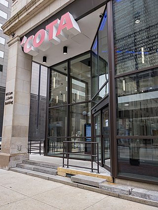
The Central Ohio Transit Authority is a public transit agency serving the Columbus metropolitan area, headquartered in Columbus, Ohio. It operates fixed-route buses, bus rapid transit, microtransit, and paratransit services.

Westgate is a community within the Hilltop area of Columbus, Ohio. It was partially constructed on land that formerly housed the American Civil War Camp Chase and a Confederate prison. After the Civil War, the land was purchased by Joseph Binns and his associates with the intent to start a Quaker community. These plans failed to materialize and the land was developed as a "streetcar suburb" in the 1920s. Located 4 miles (6.4 km) west of downtown, the neighborhood is home to Westgate Park and Recreation Center, Westgate Alternative Elementary School, St. Mary Magdalene Church and school, and Parkview United Methodist Church. 4,500 residents live within the Westgate boundaries, most in single family houses.

Olentangy West is a neighborhood approximately 5 miles (8 km) northwest of downtown Columbus, Ohio, United States. Also called West Olentangy, it is generally bordered by West Henderson Road on the north, the Olentangy River and Clintonville on the east, Kinnear Road on the south, and Upper Arlington on the west. The area is primarily residential, although the large Riverside Methodist Hospital and the headquarters for Chemical Abstracts Service are located within its boundaries. Additionally, the west campus of Ohio State University is located within the southern boundary of the area.
The Columbus, Ohio metropolitan area is a metropolitan area in Central Ohio surrounding the state capital of Columbus. As defined by the U.S. Census Bureau, it includes the counties of Delaware, Fairfield, Franklin, Hocking, Licking, Madison, Morrow, Perry, Pickaway, and Union. At the 2020 census, the MSA had a population of 2,138,926, making it 32nd-most populous in the United States and the second largest in Ohio, behind the Cincinnati metropolitan area. The metro area, also known as Central Ohio or Greater Columbus, is one of the largest and fastest-growing metropolitan areas in the Midwestern United States.
Linden is a neighborhood in northeastern Columbus, Ohio. It was established in 1908 as Linden Heights Village, and was annexed into Columbus in 1921. The neighborhood saw high levels of development in the 1920s. By the 1960s, suburban development and racial factors caused families, especially white residents, to leave the neighborhood. Since this time, Linden has struggled with poverty, crime, vacancies, and health and societal problems.
The Near East Side is a neighborhood located near downtown Columbus, Ohio, made up of several neighborhoods: Mount Vernon, King-Lincoln Bronzeville, Eastgate, Franklin Park, Nelson Park, Olde Towne East, and Woodland Park.
West Columbus, sometimes referred to as westside or the West Side, is a neighborhood in Columbus, Ohio, United States. Unlike other Columbus neighborhoods, it is a broad geographical term used by locals rather than a subdivision or suburb. West Columbus is defined as the entire southwest side of Columbus, bordered on the north by interstates 70 and 670, within Interstate 71 on the east, and on the south and west by the city limits that reach several miles to the outside of the I-270 outerbelt. It covers the ZIP Codes 43223, 43204, 43228, and 43222.

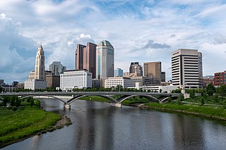
Downtown Columbus is the central business district of Columbus, Ohio. Downtown is centered on the intersection of Broad and High Streets, and encompasses all of the area inside the Inner Belt. Downtown is home to most of the tallest buildings in Columbus.

Olde Towne East is a neighborhood located in the historical Near East Side of Columbus, Ohio and is one of Columbus' oldest neighborhoods. The area has over 1,000 homes, some as old as the 1830s, and more than 50 architectural styles as a result of its history. These homes were built by many of the famous individuals of Columbus including industrialists, lawyers, judges, teachers, architects, mayors, governors, and legislators, many of whom shaped the city.
Columbus, the state capital and Ohio's largest city, has numerous neighborhoods within its city limits. Neighborhood names and boundaries are not officially defined. They may vary or change from time to time due to demographic and economic variables.

Harrison West is a historic urban neighborhood located northwest of downtown Columbus, Ohio. It sits on several blocks along the Olentangy River and includes the western part of the Near Northside Historic District, which was placed on the National Register of Historic Places in 1975. The character of the neighborhood is similar to Victorian Village, which sits just to the east and is more well-known.
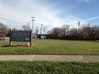
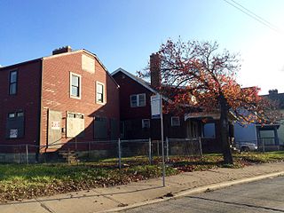
Driving Park is an urban residential area on the Near East Side of Columbus, Ohio just south of Interstate 70. Mainly a middle-class, predominantly African American neighborhood, Driving Park and its surrounding neighborhoods consist of an area of 17,730 residents. Driving Park received its name from its historic past as a large racing complex, first for horses and later for automobiles.
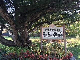
Old Oaks Historic District, or Old Oaks, is a neighborhood just south and east of downtown Columbus, Ohio and is an example of a streetcar suburb in the city.

The city of Columbus is located in central Ohio at the confluence of the Scioto and Olentangy rivers. The region is dominated by a humid continental climate, characterized by hot, muggy summers and cold, dry winters.

Weinland Park is a neighborhood north of downtown Columbus, Ohio and encompassed by the boundaries of the University District. A development boom in the 1930s and 1940s resulting from new streetcar lines and the blossoming of factories brought working and middle-class families to the neighborhood. Current housing stock consists primarily of single family residential buildings that have been converted to rentals or multifamily housing. Row-homes and apartment buildings are also ubiquitous in the neighborhood. Renters currently outnumber owners. Commercial and entertainment facilities are concentrated on the North High Street corridor, but also pocket the inner part of the neighborhood as well. Weinland Park saw the sapping of its population and wealth with the rise of newer suburbs ringing the outer reaches of the city and the collapse of local industry and streetcar lines. The neighborhood has been plagued with crime and drug problems for decades but has recently seen a flood of new investment that has brought growth and revitalization to this long struggling neighborhood. Investment into the community includes the South Campus Gateway providing retail and residential finished in 2005, and a new food district and employment center.

Franklin Park is a neighborhood located on the Near East Side of Columbus, Ohio. Both the historic neighborhood and landmark, the Franklin Park Conservatory and Botanical Gardens, are named after the 88-acre park.

Southern Orchards is an established neighborhood near the south side of Columbus, Ohio. It is located immediately southeast of downtown and is the 23rd most walkable neighborhood in Columbus with 3,538 residents. The neighborhood is the target of revitalization and beautification largely due to its anchor institution Nationwide Children's Hospital and a renewed interest in urban living in the city's core. Since 2008, more than 90 properties have been improved through the hospital’s Healthy Homes program and continued revitalization is occurring along the major streets of Livingston and Parsons Avenues as the city moves to reconnect downtown to its surrounding neighborhoods.
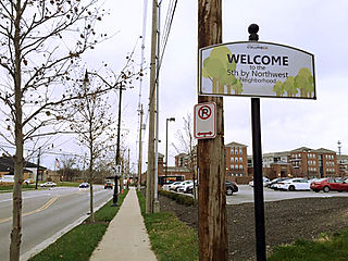
Fifth by Northwest is a neighborhood in Columbus, Ohio. Covering about 700 acres (280 ha), Fifth by Northwest is approximately bound by Glenn Avenue, Wyandotte Road, & Kinnear to the north, Third Avenue to the south, Kenny Road and Olentangy River Road to the east and Northstar Road to the west. Also sometimes referred to as 5XNW or the Tri-Village area, Fifth by Northwest is just north of Grandview Heights, northwest of the Harrison West neighborhood, and west of The Ohio State University.