Milo-Grogan

Last updated
Milo-Grogan
Milo-Grogan
Interactive map of the neighborhood
Coordinates: 39°59′11″N82°59′21″W / 39.986441°N 82.989129°W / 39.986441; -82.989129
Country United States
State Ohio
County Franklin
City Columbus
ZIP Code
43201

Milo-Grogan is a neighborhood of Columbus, Ohio. The neighborhood was settled as the separate communities of Milo and Grogan in the late 1870s. Large-scale industrial development fueled the neighborhood's growth until the 1980s, when the last factories closed. The community has received urban renewal efforts in recent years fueled by the Columbus Department of Development and Milo-Grogan Area Commission.

Contents

History

Prior to 1900

Separate communities of Milo and Grogan were established by Jonathon Fallis Linton, one of Columbus's largest land brokers, just before the turn of the twentieth century. "Milo" originates from a man named Milo Streets who owned a brickyard at the corner of St. Clair and Third Avenue. "Grogan" derives from John Patrick Grogan who opened a grocery store and post office on Cleveland Avenue. Milo stretched from First Avenue along Cleveland Avenue and west to the railroad tracks. Grogan was east of Milo and extended to eleventh Avenue on both sides of Cleveland Avenue. [1] :39 The boundaries of Milo and Grogan were never clear, so identifying the area as "Milo-Grogan" became popular. The unification of Milo-Grogan was further promoted by Cleveland Avenue which was shared by the communities and used as a business strip. [2]

Milo-Grogan developed in response to factories that settled in the late nineteenth century. Kilbourne and Jacobs Manufacturing Co., a wheelbarrow company, was the first to move into the area. The factory opened a plant half a mile northeast from Union Station on the west side of the railroad tracks. In 1880, the Berry Brothers Bolt Works established a factory just north of Kilbourne and Jacobs and later built a second, smaller factory next to the original. The Jeffrey Manufacturing Company also moved into the area around the same time and built a massive industrial factory along the northbound rail line. Jeffrey Manufacturing eventually took over most of the area from First Avenue to Lincoln towards Second Avenue and Fourth Street. [1] :39 Timken Company, Columbus Dye, and the Columbus Transit Company were other companies that were located in the Milo-Grogan area. [2]

After 1900

The Jeffrey Manufacturing Company flourished in Milo-Grogan and provided many services for its employees. J.A. Jeffrey, owner of Jeffrey Manufacturing, established one of the earliest industrial infirmaries in 1889 and a cooperative store in 1904 in the factory block. [1] :37 In 1912, Jeffrey also set up an employee cafeteria and a Building and Loan Association that helped financially assist its employees in building their homes. The employee population was quickly growing in Milo- Grogan and Columbus could not keep up with its police force, water, electricity, and fire services, causing an annexation from the city. [2]

The Jeffrey Manufacturing Company steadily grew until 1940. In 1904, Jeffrey purchased the Ohio Malleable Iron Company to ensure a reliable supply of iron for the production of their barrows and hand trucks. Ohio Malleable was located along the same railroad track as Jeffrey a few blocks north of First Avenue. In 1926, Jeffrey purchased a British company called the Diamond Coal Cutter Company, which was renamed the British Jeffrey Diamond Limited. [1] :37 A couple years later, J.A. Jeffrey retired and president of the company, Robert Gillespie stepped up. His first action as the figurehead was to invest two million dollars into the purchase of Galion Iron Works, a manufacturer of road rollers and graders for sale to local and state governments. Jeffrey Manufacturing survived the Great Depression and company prosperity continued into the immediate post war years. However, a new company called Jay Manufacturing moved into central Ohio and began challenging Jeffrey Manufacturing. Jeffrey began to fail when the company neglected to replace its underground coal hauler with the new rubber tired hauler, an innovation that would save the company time and money because the rubber tires did not require built tracks as mine shafts were extended. As the Jeffrey main branch began to fail, its subsidiaries excelled and kept the company afloat. [1] :39 In 1961, Jeffrey Manufacturing completely merged with the British Galion Company, creating the new corporate name of Jeffrey Galion, Inc.

The factories of Milo-Grogan were very successful and its employee-based neighborhoods were large, but the introduction of the Interstate 71 corridor caused a strain on the neighborhood. The interstate split the area nearly in half and several homes and businesses were demolished in the process. Layoffs were frequent after the demolition of many Milo-Grogan factories. Decreased housing availability due to I-71 construction caused the population to fall from 3850 to 3000 from 1970 to 1980. Many of the remaining families moved out of the Milo-Grogan area and into the nicer homes of the suburbs. Over 400 homes and businesses were lost to the completion of the freeway by 1964. [2]

Geography

The Milo-Grogan community area is defined by the rail corridor to the north, east, and west, and Interstate 670 to the south. For some purposes, Milo-Grogan's community area is often expanded to include a small community just northwest bounded by Eleventh Avenue to the north, Interstate 71 to the east, and a rail corridor to the south and west. Historically, Milo-Grogan was the separate communities of Milo and Grogan. Milo was located on the west side of present-day Milo-Grogan, while Grogan was located on its east side. Milo-Grogan is directly north of Downtown Columbus. It is bordered by Italian Village and Weinland Park to the west, The Fairgrounds and South Linden to the north, and Amercrest and the Devon Triangle to the east.

Development

The City of Columbus has designated Milo-Grogan as a Community Reinvestment Area that is "ready for revitalization", with available 15-year, 100 percent tax abatements for all projects that include 10 percent affordable housing, with options to buy out of the requirement. [3]

Milo-Grogan Area Commission

The Milo-Grogan Area Commission serves the area as the community link to the city of Columbus. It holds monthly meetings that present information about topics that directly affect the Milo-Grogan Neighborhood, including information related to neighborhood redevelopment. The Milo-Grogan Area Commission, in partnership with the city of Columbus, also published the Milo-Grogan 2007 Neighborhood Plan, which established goals for the community for the next 10 years. [4]

Structures and landmarks

Milo Arts

Milo Arts Milo Arts.jpg
Milo Arts

Milo Arts is a community arts center that has hosted creative events in the visual and performing arts since 1988. Housing in the old Milo Public Elementary School, the center saw considerable change in 2000 and 2001 when city officials requested closure due to fire risk and building maintenance issues. Today, the center's studio space hosts 29 local artists who live and work in the building and offer educational opportunities to area youth. [5]

It is, along with the former Columbus Railway Power and Light office and ticket office, one of the two most important historic structures in Milo-Grogan. It is a top priority for preservation for neighborhood leaders. [6]

Streetcar office

The former Columbus Railway, Power & Light office, 2021 Columbus Railway, Power & Light office 02.jpg
The former Columbus Railway, Power & Light office, 2021

The former Columbus Railway, Power & Light office is situated at 842 Cleveland Avenue. The two-story brick building has a steep gable roof and a tall rounded corner tower topped with a conical slate roof. It is located at the southern entrance to the neighborhood. It was built in the 1890s by the Columbus Central Railway Company, which became the Columbus Railway Power & Light Co. in 1914. The building was part of a complex of a power plant and streetcar barn during its operation; those buildings have since been demolished. [1]

It is, along with the Milo Arts building, one of the two most important historic structures in Milo-Grogan. It is a top priority for preservation for neighborhood leaders. [6]

Milo-Grogan Recreation Center

The Milo-Grogan Recreation Center is the primary public recreation facility in Milo-Grogan. The center operates a renovated neighborhood facility with a large number of public programs. [7] The current facility includes an art room, ceramics room, craft room, gymnasium, kitchen, and weight room. [8]

Related Research Articles

<span class="mw-page-title-main">Hilltop (Columbus, Ohio)</span> Neighborhood of Columbus in Franklin, Ohio, United States

Hilltop is one of the largest neighborhoods in Columbus, Ohio, located west of Franklinton and Downtown. The Greater Hilltop area contains newer and historic neighborhoods, schools, various stores, industrial areas, and recreational facilities. The development pattern is considered a distinct suburb. The majority of the area is predominantly single family residential.

<span class="mw-page-title-main">Franklinton (Columbus, Ohio)</span> Neighborhood in Columbus, Ohio

Franklinton is a neighborhood in Columbus, Ohio, just west of its downtown. Settled in 1797, Franklinton is the first American settlement in Franklin County, and was the county seat until 1824. As the city of Columbus grew, the city annexed and incorporated the existing settlement in 1859. Franklinton is bordered by the Scioto River on the north and east, Harmon Avenue on the east, Stimmel Road and Greenlawn Avenue on the south, and Interstate 70 on the west. Its main thoroughfare is West Broad Street, one of the city's two main roads.

<span class="mw-page-title-main">Italian Village</span> Neighborhood of Columbus in Franklin, Ohio, United States

Italian Village is a neighborhood in Columbus, Ohio, that contains an array of residential, commercial, and industrial buildings. It is a designated historic district, known for its historical and cultural preservation. The building types and architecture reflect Italian influence. With its parks and preserved historic homes, Italian Village has the highest home value appreciation in Columbus.

<span class="mw-page-title-main">Columbus metropolitan area, Ohio</span> Metropolitan statistical area in Ohio, United States

The Columbus, Ohio metropolitan area is a metropolitan area in Central Ohio surrounding the state capital of Columbus. As defined by the U.S. Census Bureau, it includes the counties of Delaware, Fairfield, Franklin, Hocking, Licking, Madison, Morrow, Perry, Pickaway, and Union. At the 2020 census, the MSA had a population of 2,138,926, making it 32nd-most populous in the United States and the second largest in Ohio, behind the Cincinnati metropolitan area. The metro area, also known as Central Ohio or Greater Columbus, is one of the largest and fastest-growing metropolitan areas in the Midwestern United States.

<span class="mw-page-title-main">Linden (Columbus, Ohio)</span> Neighborhood in Columbus, Ohio

Linden is a neighborhood in northeastern Columbus, Ohio. It was established in 1908 as Linden Heights Village, and was annexed into Columbus in 1921. The neighborhood saw high levels of development in the 1920s. By the 1960s, suburban development and racial factors caused families, especially white residents, to leave the neighborhood. Since this time, Linden has struggled with poverty, crime, vacancies, and health and societal problems.

The Near East Side is a neighborhood located near downtown Columbus, Ohio, made up of several neighborhoods: Mount Vernon, King-Lincoln Bronzeville, Eastgate, Franklin Park, Nelson Park, Olde Towne East, and Woodland Park.

<span class="mw-page-title-main">Downtown Columbus, Ohio</span> Neighborhood in Columbus, Ohio

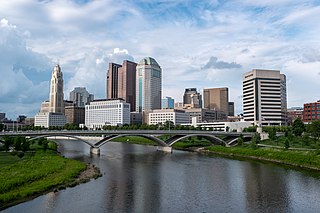
Downtown Columbus is the central business district of Columbus, Ohio. Downtown is centered on the intersection of Broad and High Streets, and encompasses all of the area inside the Inner Belt. Downtown is home to most of the tallest buildings in Columbus.

<span class="mw-page-title-main">Olde Towne East</span> Neighborhood of Columbus, Ohio, United States

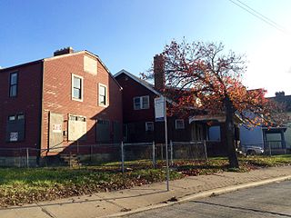
Olde Towne East is a neighborhood located in the historical Near East Side of Columbus, Ohio and is one of Columbus' oldest neighborhoods. The area has over 1,000 homes, some as old as the 1830s, and more than 50 architectural styles as a result of its history. These homes were built by many of the famous individuals of Columbus including industrialists, lawyers, judges, teachers, architects, mayors, governors, and legislators, many of whom shaped the city.

Columbus, the state capital and Ohio's largest city, has numerous neighborhoods within its city limits. Neighborhood names and boundaries are not officially defined. They may vary or change from time to time due to demographic and economic variables.

<span class="mw-page-title-main">Driving Park</span> Neighborhood in Columbus, Ohio, U.S.

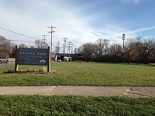
Driving Park is an urban residential area on the Near East Side of Columbus, Ohio just south of Interstate 70. Mainly a middle-class, predominantly African American neighborhood, Driving Park and its surrounding neighborhoods consist of an area of 17,730 residents. Driving Park received its name from its historic past as a large racing complex, first for horses and later for automobiles.

The community of Forest Park consists of almost 2900 private residential properties, plus apartments, condominiums, commercial properties, city-owned parks and schools, in approximately 1.4 square miles (3.6 km2) of the Northland area of northeast Columbus, Ohio. These properties adjoin a total of 132 distinct streets and courts maintained by the City of Columbus. The community's approximate center is near the intersection of Karl Road and Sandalwood Place in Columbus.

<span class="mw-page-title-main">Woodland Park (Columbus, Ohio)</span> Neighborhood of Columbus in Franklin, Ohio, United States

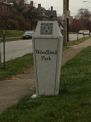
Woodland Park is a residential neighborhood located in the Near East Side of Columbus, Ohio that houses approximately 1,500 residents. The neighborhood was previously home to such figures as artist Emerson Burkhart, cartoonist Billy Ireland, and judge William Brooks. Established in the early 20th century, Woodland Park has grown from its planned neighborhood roots into a neighborhood that contains various faith communities, schools, sources of entertainment and recreation, and borders an extension of the Ohio State University medical center.

<span class="mw-page-title-main">Weinland Park</span> Neighborhood of Columbus in Franklin, Ohio, United States

Weinland Park is a neighborhood north of downtown Columbus, Ohio and encompassed by the boundaries of the University District. A development boom in the 1930s and 1940s resulting from new streetcar lines and the blossoming of factories brought working and middle-class families to the neighborhood. Current housing stock consists primarily of single family residential buildings that have been converted to rentals or multifamily housing. Row-homes and apartment buildings are also ubiquitous in the neighborhood. Renters currently outnumber owners. Commercial and entertainment facilities are concentrated on the North High Street corridor, but also pocket the inner part of the neighborhood as well. Weinland Park saw the sapping of its population and wealth with the rise of newer suburbs ringing the outer reaches of the city and the collapse of local industry and streetcar lines. The neighborhood has been plagued with crime and drug problems for decades but has recently seen a flood of new investment that has brought growth and revitalization to this long struggling neighborhood. Investment into the community includes the South Campus Gateway providing retail and residential finished in 2005, and a new food district and employment center.

<span class="mw-page-title-main">Southern Orchards</span> Place

Southern Orchards is an established neighborhood near the south side of Columbus, Ohio. It is located immediately southeast of downtown and is the 23rd most walkable neighborhood in Columbus with 3,538 residents. The neighborhood is the target of revitalization and beautification largely due to its anchor institution Nationwide Children's Hospital and a renewed interest in urban living in the city's core. Since 2008, more than 90 properties have been improved through the hospital’s Healthy Homes program and continued revitalization is occurring along the major streets of Livingston and Parsons Avenues as the city moves to reconnect downtown to its surrounding neighborhoods.

<span class="mw-page-title-main">Union–Miles Park</span> Neighborhood of Cleveland, Ohio, United States

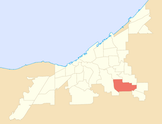
Union–Miles Park is a neighborhood on the Southeast side of Cleveland, Ohio, in the United States. The neighborhood draws its name from Union Avenue, and Miles Park in its far southwest corner.

<span class="mw-page-title-main">Kilbourne and Jacobs Manufacturing Co.</span>

Kilbourne and Jacobs Manufacturing Company was founded in 1881 by James Kilbourne and HL Jacobs in Columbus, Ohio with an initial investment of $100,000. Built in close proximity to Union Station, the company produced wheelbarrows, horse-drawn railroad scrapers and other earth-moving equipment during the turn of the century. Several years after opening, the company developed a line of hand trucks, forty percent of which were sold to the New York Central Railroad. By the end of the 19th century, Kilbourne and Jacobs was the largest manufacturer of earth-moving equipment in the United States. The Ohio State Journal reported in 1890 that the company produced approximately 150,000 hand trucks per year with between 400-600 workers, pushing annual sales to nearly $1 million.

<span class="mw-page-title-main">Jeffrey Manufacturing Company</span>

The Jeffrey Manufacturing Company was one of the largest industrial plants in Columbus, Ohio during the Second Industrial Revolution. It belonged to the original cluster of factories which were set up in the Milo-Grogan area of the city, including manufacturer Kilbourne and Jacobs. During this period, Ohio's economy transformed from agricultural to industrial, making the state one of the largest coal-producing and consuming states in the US. Manufacturers in the region stimulated the transformation by producing high volumes of railroad and mining equipment and farming machinery. According to the COSI Center of Science and Industry, the Jeffrey Manufacturing Company played a significant role in the success of the coal mine.

<span class="mw-page-title-main">CMAX</span> Bus rapid transit line in Columbus, Ohio

CMAX is a bus rapid transit (BRT) service in Central Ohio, operated by the Central Ohio Transit Authority (COTA). The line begins in Downtown Columbus, traveling northeast to Westerville. CMAX is Central Ohio's first bus rapid transit line; it began operation in 2018.

<span class="mw-page-title-main">Columbus Railway, Power & Light office</span> Former railway building in Columbus, Ohio

The former Columbus Railway, Power & Light office is a historic building in the Milo-Grogan neighborhood of Columbus, Ohio. The two-story brick structure was designed by Yost & Packard and built in the 1890s as a transportation company office. The property was part of a complex of buildings, including a power plant, streetcar barn, and inspection shop. The office building, the only remaining portion of the property, was utilized as a transit office into the 1980s, and has remained vacant since then. Amid deterioration and lack of redevelopment, the site has been on Columbus Landmarks' list of endangered sites since 2014.

<span class="mw-page-title-main">Milo Arts</span> Arts center in Columbus, Ohio

Milo Arts is a community arts center and former public school building in the Milo-Grogan neighborhood of Columbus, Ohio. The arts center was founded in 1988, and was considered a radical concept at the time. It is the longest-lasting artist live-work space in Columbus.

References

  1. 1 2 3 4 5 6 Dunham, Tom (2010). Columbus's Industrial Communities: Olentangy, Milo-Grogan, Steelton. Bloomington, IN: AuthorHouse. ISBN   978-1-4520-5970-9.
  2. 1 2 3 4 Department of Development. "Milo-Grogan Neighborhood Plan" (PDF). City of Columbus. Retrieved April 20, 2014.
  3. "Community Reinvestment Areas" (PDF). City of Columbus Department of Development. May 23, 2018. Retrieved November 30, 2020.
  4. "Milo-Grogan AC- Chair". The City of Columbus Department of Development. Archived from the original on 27 April 2014. Retrieved 20 April 2014.
  5. "Milo Arts". Heritage Properties. Retrieved April 20, 2014.
  6. 1 2 https://www.columbus.gov/WorkArea/DownloadAsset.aspx?id=2147489233 [ bare URL PDF ]
  7. Williams, Sherri. "Milo-Grogan: Counting on a rebirth". The Columbus Dispatch. Retrieved 20 April 2014.
  8. "Milo Grogan Community Recreation Center". The City of Columbus Department of Recreation and Parks. Archived from the original on 27 April 2014. Retrieved 20 April 2014.