Woodland Park (Columbus, Ohio)

Last updated
Woodland Park
Woodland Park Columbus Welcome Sign.jpg
Neighborhood Marker for Woodland Park
Woodland Park (Columbus, Ohio)
Interactive map of the neighborhood
Coordinates: 39°58′08″N82°57′30″W / 39.9689451°N 82.9584316°W / 39.9689451; -82.9584316
Country United States
State Ohio
County Franklin
City Columbus
ZIP Code
43203, 43219
Area code 614

Woodland Park is a residential neighborhood located in the Near East Side of Columbus, Ohio that houses approximately 1,500 residents. [1] The neighborhood was previously home to such figures as artist Emerson Burkhart, cartoonist Billy Ireland, and judge William Brooks. [2] Established in the early 20th century, Woodland Park has grown from its planned neighborhood roots into a neighborhood that contains various faith communities, schools, sources of entertainment and recreation, and borders an extension of the Ohio State University medical center.

Contents

History

The original advertisement for Woodland Park Woodland Park Ad from the Columbus Dispatch 1904.jpg
The original advertisement for Woodland Park

Woodland Park, one of Columbus’ first planned neighborhoods, is named for Woodland Avenue and the Woodland Park Addition. Woodland Park Addition is a subdivision that can be identified as early as 1899. The first homes in the area were built in the mid-1890s. At the center of Woodland Park Addition is Hawthorne Park bounded by Hawthorne Park Road. Development of Woodland Park Addition was limited and located primarily along Long Street and Woodland Ave. [3] An advertisement in the Columbus Dispatch on June 26, 1904 boasted the amenities offered in the neighborhood; "We give you paved streets, cement sidewalks, water, gas, sewerage, electric lights, plenty of fine forest trees and one of the best school districts in the city. Woodland Park Addition has the advantage of three electric car lines by which you can reach High Street in fifteen minutes." [4]

Throughout the 20th century, owners motivated by racism put restrictions in deeds preventing those of African descent from purchasing homes. However, these restrictions eventually became irrelevant, as wealthy African American professionals and musicians could pay the sellers overwhelming amounts of money for said homes. [5] Wexner Heritage Village can cite its beginnings back to Woodland Park. [6] In an interview conducted by the Columbus Jewish Historical Society, Annette Tanenbaum notes that the Heritage House was located on Woodland Avenue near Long Street. She adds that it was the first facility in Columbus dedicated to taking care of elderly Jewish people. [7] Heritage House was built in 1951. [6] Today the Wexner Heritage Village continues to provide elderly care to people in the Jewish community. [8]

Geography

Woodland Park is located within the Near East Side of Columbus, Ohio. It is a centrally located neighborhood and two miles away from Downtown Columbus. It is also under the jurisdiction of the Near East Side Area Commission.

The boundaries of the Woodland Park Addition are Clifton Avenue to the north, Long Street to the south, Woodland Avenue to the east and Parkwood Avenue (formerly Mulberry Street) to the west. Over time, recognized boundaries of the neighborhood expanded, and the modern boundaries are I-670 or Maryland Avenue to the North, Broad Street to the south, the Norfolk and Western Railroad to the east, and Taylor Avenue to the west. [9]

Woodland Park is adjacent to the neighborhoods of Shepard to the north, Franklin Park to the south, Eastgate to the east, and King-Lincoln Bronzeville and Mount Vernon to the west. Portions of Woodland Park also overlap with Eastwood Heights. [10]

Landmarks

The Martin Luther King Branch of the Columbus library on E. Long Street Columbus Metropolitan Library Wodland Park Branch.jpg
The Martin Luther King Branch of the Columbus library on E. Long Street

Woodland Park includes a stretch of Broad Street that is included in the East Broad Street Historic District. East Broad Street contains multiple structures that were constructed in the early 1900s, with 88% being residential in nature. These structures represent the height of Broad Street's development. [11]

Other landmarks include the following:

Transportation

COTA is one of many ways to get through the city of Columbus. COTA Bus Stop on Broad Street in Woodland Park, Columbus, OH.JPG
COTA is one of many ways to get through the city of Columbus.

Woodland Park's southern boundary, Broad Street, is notable because of its history as the National Road. [12] Woodland Park’s eastern boundary, the Norfolk and Southern Railroad, is notable as well. Originally constructed as the Scioto Valley Railroad, and later operated as the Ohio Subdivision of the Norfolk and Southern Railroad. The railroad terminated about a mile and a half, or less, north of Fifth Avenue in the modern day Americrest neighborhood.

The neighborhood once had a streetcar line that connected it with downtown. The streetcar went east-to-west along Long Street, and turned north-to-south to connect Long to Broad Street, and to the north side of Franklin Park. The Streetcar began service prior to 1905 in ceased operations shortly after 1940. [13] Additionally, there are 10 Central Ohio Transit Authority, or COTA, bus stops in the neighborhood with access to the No. 6, the "Sullivant" route, and No. 10, the "East Broad Street” route. Other COTA routes include the No. 16 and No. 81 routes. [14]

Residential

A bed and breakfast in Woodland Park A Woodland Park Bed and Breakfast in the Woodland Park Neighborhood of Columbus, OH.png
A bed and breakfast in Woodland Park

Demographics

Demographically, the primary residents of Woodland Park are African Americans with the second most residents classifying themselves as White. Median household income in Woodland Park is slightly below the median income of Columbus, measuring at $24,568 in 2011. Accordingly, median rent in the neighborhood measured at $456 per month in 2011 also. The median age of men and women in Woodland Park is 35, with an average of 2.1 people per household. [1]

Architecture

The residential area of Woodland Park can be described as a variety of houses with different architecture styles. It is made up of large homes and mansions, town-homes, bungalows, and apartments. [15] Architecture styles of Woodland Park homes range from Queen Anne, Tudor, Greek Revival, Cape Cod, Colonial Revival and Dutch Colonial styles. [15] Woodland Park is home to a Lustron Home that was built in 1950 at 1818 East Long Street. The home is a Westchester Deluxe model. The Lustron Corporation of Columbus built these prefabricated homes after World War II to meet housing shortages. [16]

Park Towers

Park Towers is a collection of condominiums found at 1620 East Broad Street in the Woodland Park neighborhood. The structure was built in the early 1960s. Park Towers includes office suites on the first floor and 141 private residences available for purchase on the remaining floors. Common areas of the Park Towers building include a lobby, exercise facility, and community garden for residents. [17]

Emerson Burkhart home

Artist Emerson Burkhart moved to Woodland Park in the mid 20th century and resided at 223 Woodland Avenue until his death in 1969. Annually Burkhart opened his Woodland Avenue home to the public for an open house art show. Thousands of people visited the 22 room home to view the artist's pieces and his home. [18]

Religion

The largely residential neighborhood boasts several churches, including the Saint Phillip Lutheran Church, Ashbury United Methodist Church, United House of Prayer, and the Jerusalem Tabernacle Baptist Church.

The St. Philip Episcopal Church held its first service in 1891 on the corner of Cleveland Avenue and Naughten Street in downtown Columbus, Ohio. In 1962 the church was relocated to Woodland Park at 166 Woodland Ave. The church continues to congregate in Woodland Park. [19]

In addition to serving its community in a religious role, Woodland Christian Church serves the community in a political role. The church's website claims that it values justice and provides residents such resources as the opportunity to register to vote, election information, and encourages political organization through its Political Action Team. [20]

Education

Mansion Day School

The Mansion Day School New Mansion Day School Picture.png
The Mansion Day School

What is today known as the Mansion Day School was originally a mansion built for William A. Miller in 1904, designed by David Riebel. The structure, known as Miller's statement house, has 24 rooms with 15 fireplaces and includes Italian tile and mahogany. William A. Miller was the president of the H.C. Godman shoe company, which had four factories in Columbus, Ohio and four factories in Lancaster, Ohio. The company had up to 3,000 employees at the time of Miller's death in 1921. His wife Anna was a philanthropist and opened the third floor of their home to homeless children. In 1934 the structure was purchased by the Glenmont Home for Christian Scientists and was turned into a nursing home.

The structure has operated for two decades as the Mansion Day School. The elementary school is headed by executive director Dee James and serves students from across greater the greater Columbus area, including the cities of Gahanna, Pickerington, and Dublin. [5] The school is unique because it has a competitive application for admittance. [21]

East High School

Woodland Park is also home to East High School, a historic public school located at 1500 East Broad Street that is part of Columbus City Schools. Architects Howell and Thomas designed the original school which was built in 1922. East High School was one of five high schools built in accordance with the Smith-Hughes Act whose purpose was to provide federal funding to communities and expand educational opportunities. The school is notable for its connection to the African American population of Columbus and the various famous students that graduated from there, including actor Philip Michael Thomas and athlete and actor Bernie Casey. [22] Today, the school is led by principal Ernest C Wood, Jr. and teaches from the 9th-12th grade. East High School prides itself in offering a college preparatory curriculum and claims that over $3.5 million worth of scholarships were awarded to the graduating class of 2013. Various clubs offered by East High School include a Science, Technology, Engineering, and Mathematics Club, National Honor Society, a poetry slam, and marching band and drill team. [23]

Entertainment and recreation

The Eldon and Elsie Ward YMCA is located on Woodland Ave. Woodland Park Columbus OH YMCA.JPG
The Eldon and Elsie Ward YMCA is located on Woodland Ave.

Franklin Park Conservatory

The Franklin Park Conservatory is located just south of Woodland Park, on the south side of Broad Street. The greenhouse, now known as the Palm House, was inspired by the architecture of the Chicago World's Fair and Columbian Exposition and the City Beautiful movement. Franklin Park Conservatory opened to the public in 1895 and in addition to the greenhouse provided the public with carriage paths, a lake, and a boathouse. The park was run by the Columbus Recreation and Parks Department until 1989 when ownership was transferred to a 10 member board of trustees and executive director [24]

Columbus Metropolitan Library

Woodland Park is also home to a branch of the Columbus Metropolitan Library. The "Martin Luther King" branch located on E. Long Street offers programming such as a TedX club, where teenagers can work with students from the Ohio State University to come up with inspirational speeches based on their own life experiences. Other programs include reading workshops to help children develop reading comprehension skills outside of the regular classroom. Daily programs include homework help for children in school and job searching advice for older individuals. [25]

Eldon and Elsie Ward YMCA

Originally known as the Spring Street YMCA, The Eldon and Elsie Ward YMCA was founded in 1919. It was one of the first YMCAs in the United States that was principally designated to serve a black community. In 1962, the YMCA moved to the Woodland Avenue location where it presently sits and was renamed the East Side YMCA. In 1997 it again underwent a name change and was named the Eldon and Elsie Ward YMCA to honor their lifelong support of the Columbus community. Eldon Ward was most well known as the head of the E.E. Ward Moving and Transit Company, but he was also a Sunday school teacher and leader in the community. [26] Today, the YMCA named after the late couple offers community members recreational classes as well as facilities such as a gymnasium and a pool. The YMCA of Central Ohio cites part of its key tenants as "youth development, healthy living, and social responsibility". [27]

Related Research Articles

<span class="mw-page-title-main">Columbus, Ohio</span> Capital and largest city of Ohio, United States

Columbus is the capital and most populous city of the U.S. state of Ohio. With a 2020 census population of 905,748, it is the 14th-most populous city in the U.S., the second-most populous city in the Midwest after Chicago, and the third-most populous U.S. state capital after Phoenix, Arizona and Austin, Texas. Columbus is the county seat of Franklin County; it also extends into Delaware and Fairfield counties. It is the core city of the Columbus metropolitan area, which encompasses ten counties in central Ohio. It had a population of 2,138,926 in 2020, making it the largest metropolitan area entirely in Ohio and 32nd-largest metro area in the U.S.

<span class="mw-page-title-main">Bexley, Ohio</span> City in Ohio, United States

Bexley is a suburban city in Franklin County, Ohio, United States. The population was 13,928 at the 2020 census. Founded as a village, the city of Bexley is a suburb of Columbus, the Ohio state capital, situated on the banks of Alum Creek next to Driving Park and Wolfe Park, just east of the Franklin Park Conservatory. It is horizontally bisected by the National Road, serving as a reminder of Bexley's origins as a merger between the prestigious Bullitt Park neighborhood to the north, and the Lutheran college community of Pleasant Ridge to the south.

<span class="mw-page-title-main">Hilltop (Columbus, Ohio)</span> Neighborhood of Columbus in Franklin, Ohio, United States

Hilltop is one of the largest neighborhoods in Columbus, Ohio, located west of Franklinton and Downtown. The Greater Hilltop area contains newer and historic neighborhoods, schools, various stores, industrial areas, and recreational facilities. The development pattern is considered a distinct suburb. The majority of the area is predominantly single family residential.

<span class="mw-page-title-main">Franklinton (Columbus, Ohio)</span> Neighborhood in Columbus, Ohio

Franklinton is a neighborhood in Columbus, Ohio, just west of its downtown. Settled in 1797, Franklinton is the first American settlement in Franklin County, and was the county seat until 1824. As the city of Columbus grew, the city annexed and incorporated the existing settlement in 1859. Franklinton is bordered by the Scioto River on the north and east, Harmon Avenue on the east, Stimmel Road and Greenlawn Avenue on the south, and Interstate 70 on the west. Its main thoroughfare is West Broad Street, one of the city's two main roads.

The University District, is a 2.8-square-mile (7.3 km2) area located 2 miles (3.2 km) north of Downtown Columbus, Ohio that is home to the main campus of Ohio State University, the Battelle Institute, and Wexner Medical Center. It is generally accepted as the area bounded to the north by Clintonville at Glen Echo Ravine; to the south by the Short North at 5th Avenue; to the west by the Olentangy River and to east by the Conrail railroad tracks. Points of interest include, but are not limited to, the Ohio Stadium and Old North Columbus. The district is Columbus' most densely populated area and contains more than 650 businesses, human service agencies, churches, and schools. University District businesses include boutiques, mixed retail, several tattoo studios, the Gateway Film Center, and a diverse range of restaurants and bars.

<span class="mw-page-title-main">Italian Village</span> Neighborhood of Columbus in Franklin, Ohio, United States

Italian Village is a neighborhood in Columbus, Ohio, that contains an array of residential, commercial, and industrial buildings. It is a designated historic district, known for its historical and cultural preservation. The building types and architecture reflect Italian influence. With its parks and preserved historic homes, Italian Village has the highest home value appreciation in Columbus.

The Near East Side is a neighborhood located near downtown Columbus, Ohio, made up of several neighborhoods: Mount Vernon, King-Lincoln Bronzeville, Eastgate, Franklin Park, Nelson Park, Olde Towne East, and Woodland Park.

<span class="mw-page-title-main">Downtown Columbus, Ohio</span> Neighborhood in Columbus, Ohio

Downtown Columbus is the central business district of Columbus, Ohio. Downtown is centered on the intersection of Broad and High Streets, and encompasses all of the area inside the Inner Belt. Downtown is home to most of the tallest buildings in Columbus.

<span class="mw-page-title-main">Olde Towne East</span> Neighborhood of Columbus, Ohio, United States

Olde Towne East is a neighborhood located in the historical Near East Side of Columbus, Ohio and is one of Columbus' oldest neighborhoods. The area has over 1,000 homes, some as old as the 1830s, and more than 50 architectural styles as a result of its history. These homes were built by many of the famous individuals of Columbus including industrialists, lawyers, judges, teachers, architects, mayors, governors, and legislators, many of whom shaped the city.

Columbus, the state capital and Ohio's largest city, has numerous neighborhoods within its city limits. Neighborhood names and boundaries are not officially defined. They may vary or change from time to time due to demographic and economic variables.

<span class="mw-page-title-main">Driving Park</span> Neighborhood in Columbus, Ohio, U.S.

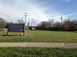
Driving Park is an urban residential area on the Near East Side of Columbus, Ohio just south of Interstate 70. Mainly a middle-class, predominantly African American neighborhood, Driving Park and its surrounding neighborhoods consist of an area of 17,730 residents. Driving Park received its name from its historic past as a large racing complex, first for horses and later for automobiles.

<span class="mw-page-title-main">King-Lincoln Bronzeville</span> Neighborhood in Columbus, Ohio

King-Lincoln Bronzeville is a historically African American neighborhood in Columbus, Ohio. Originally known as Bronzeville by the residents of the community, it was renamed the King-Lincoln District by Mayor Michael B. Coleman's administration to highlight the historical significance of the district's King Arts Complex and Lincoln Theatre, amid collaborations with investors and developers to revitalize the neighborhood.

<span class="mw-page-title-main">Geography of Columbus, Ohio</span> Topography, climate and cityscape in the city

The city of Columbus is located in central Ohio at the confluence of the Scioto and Olentangy rivers. The region is dominated by a humid continental climate, characterized by hot, muggy summers and cold, dry winters.

The community of Forest Park consists of almost 2900 private residential properties, plus apartments, condominiums, commercial properties, city-owned parks and schools, in approximately 1.4 square miles (3.6 km2) of the Northland area of northeast Columbus, Ohio. These properties adjoin a total of 132 distinct streets and courts maintained by the City of Columbus. The community's approximate center is near the intersection of Karl Road and Sandalwood Place in Columbus.

The culture of Columbus, Ohio, is particularly known for museums, performing arts, sporting events, seasonal fairs and festivals, and architecture of various styles from Greek Revival to modern architecture.

The following is a timeline of the history of the city of Columbus, Ohio, United States.

<span class="mw-page-title-main">Briggsdale (Columbus, Ohio)</span>

Briggsdale is a neighborhood of Franklin County in the city of Columbus, Ohio. The neighborhood is on the west/southwest side of the city within the Hilltop area. The area was first settled and founded by the family of Joseph M. Briggs, after whom the neighborhood was named. Joseph Briggs was an active figure in the early years of the township and county operations. The Briggsdale Methodist church was founded with his help, and it now exists as the New Horizons Methodist Church. The present-day Briggsdale neighborhood is located near the historical Green Lawn Cemetery to the north as well as Briggs High School to the west.

<span class="mw-page-title-main">Franklin Park (Columbus, Ohio)</span> Place

Franklin Park is a neighborhood located on the Near East Side of Columbus, Ohio. Both the historic neighborhood and landmark, the Franklin Park Conservatory and Botanical Gardens, are named after the 88-acre park.

<span class="mw-page-title-main">Discovery District (Columbus, Ohio)</span> Neighborhood in Columbus, Ohio

The Discovery District is a special improvement district in downtown Columbus, Ohio, the home of Columbus State Community College, Columbus College of Art and Design, Columbus Museum of Art, and Columbus Metropolitan Library. It is considered a cultural district because of its close proximity to higher educational campuses and art destinations. It was named to imply that the area is full of possibility due to the number of learning and creative campuses in this small area. "Culture, art, and academia converge and present the Discovery District." While not typically viewed as the most prominent Columbus neighborhood, the density of academic and arts-based institutions in this area are what make this creative campus unique.

References

  1. 1 2 "Woodland Park Neighborhood". City Data. Retrieved 11 November 2014.
  2. Lafever, Jeff. "Be My Neighbor: Woodland Park Edition". Columbus Underground. Retrieved 11 November 2014.
  3. "Columbus Atlas_1899_24". Columbus Metropolitan Library. Retrieved 1 December 2014.
  4. "Large 1904 Newspaper Ad for Woodland Park". Dornberg House, Stories of Woodland Park. Blogspot. 8 December 2011. Retrieved 11 November 2014.
  5. 1 2 Ferenchik, Mark (8 February 2010). "Woodland Park neighborhood like a suburb in the city". The Columbus Dispatch. Retrieved 11 November 2014.
  6. 1 2 "Wexner Heritage Village" (PDF). Retrieved 1 December 2014.
  7. "Annette Tanenbaum". Columbus Jewish Historical Society. Retrieved 1 December 2014.
  8. "About Us". Wexner Heritage Village. Retrieved 1 December 2014.
  9. "Woodland Park Neighborhood Association". Columbus Arts. Columbus Arts Council. Retrieved 11 November 2014.
  10. "Sanborn Fire Insurance Maps". Sanborn. Retrieved 16 December 2014.
  11. "National Register of Historic Places Inventory Nomination Form". National Park Service. Retrieved 1 December 2014.
  12. "Ohio National Road". Ohio National Road Association. Retrieved 16 December 2014.
  13. Steiner, Rowlee. "Roots of the Norfolk and Western Railroad in Columbus, Ohio" (PDF). Retrieved 15 December 2014.
  14. "COTA System Map" (PDF). Central Ohio Transit Authority. Retrieved 1 December 2014.[ permanent dead link ]
  15. 1 2 "Woodland Park Neighborhood Association". WayBack Machine. Archived from the original on August 28, 2008. Retrieved 29 November 2014.
  16. "1818 East Long Street". Dornberg House, Stories of Woodland Park. 11 June 2012. Retrieved 2 December 2014.
  17. "Welcome to Park Towers". Park Towers. Retrieved 15 December 2014.
  18. Thomson, Tom. "Remembering Emerson Burkhart". Short North Gazette. Retrieved 16 December 2014.
  19. "History of St. Philip's Church". St. Philip Episcopal Church. Retrieved 16 December 2014.
  20. Woodland Christian Church. "Political Action Team" . Retrieved 13 November 2014.
  21. "Mansion Day School's Mission". The Mansion Day School. Retrieved 11 November 2014.
  22. Betti, Tom; Lentz, Ed; Sauer, Doreen Uhas (2013). Columbus neighborhoods : a guide to the landmarks of Franklinton, German Village, King-Lincoln, Olde Town East, Short North & the University District. Charleston: The History Press. pp. 152–153. ISBN   978-1-60949-669-2.
  23. "East High School" (PDF). Columbus City Schools. Retrieved 11 November 2014.
  24. "History". Franklin Park Conservatory and Botanical Gardens. Retrieved 13 November 2014.
  25. "Martin Luther King". Columbus Metropolitan Library. Retrieved 1 December 2014.
  26. Betti, Tom; Lentz, Ed; Sauer, Doreen Uhas (2013). Columbus neighborhoods : a guide to the landmarks of Franklinton, German Village, King-Lincoln, Olde Town East, Short North & the University District. Charleston: The History Press. pp. 153–155. ISBN   978-1-60949-669-2.
  27. "Eldon & Elsie Ward Family YMCA". YMCA. Retrieved 1 December 2014.