
Colorado Springs is a home rule municipality in and the county seat of El Paso County, Colorado, United States. It is the largest city in El Paso County, with a population of 478,961 at the 2020 United States Census, a 15.02% increase since 2010. Colorado Springs is the second-most populous city and the most extensive city in the state of Colorado, and the 40th-most populous city in the United States. It is the principal city of the Colorado Springs metropolitan area and the second-most prominent city of the Front Range Urban Corridor. It is located in east-central Colorado, on Fountain Creek, 70 miles (113 km) south of Denver.

The Broadmoor is a hotel and resort in the Broadmoor neighborhood of Colorado Springs, Colorado. The Broadmoor is a member of Historic Hotels of America of the National Trust for Historic Preservation. Its visitors have included heads of state, celebrities, and professional sports stars. It is owned by The Anschutz Corporation through its subsidiary, The Broadmoor-Sea Island Company.

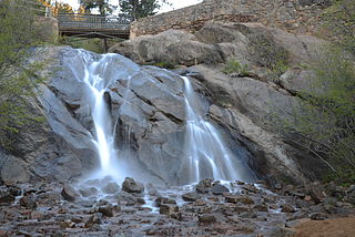
The Broadmoor Seven Falls is a series of seven cascading waterfalls of South Cheyenne Creek in South Cheyenne Cañon, Colorado Springs, Colorado. It has been a privately-owned tourist attraction since it was opened in the early 1880s. There is no parking at Seven Falls. Round trip shuttle service is provided from the Norris Penrose Event Center. Trails from the top of the falls lead to Midnight Falls, near the headwaters of South Cheyenne Creek, and Inspiration Point.
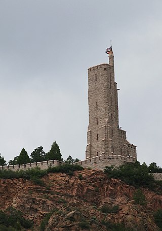
Will Rogers Shrine of the Sun, also known as Will Rogers Shrine, is a commemorative tower and chapel on Cheyenne Mountain in Colorado Springs, Colorado. It is named after Will Rogers, the American humorist, who died in a plane crash in Alaska in 1935 during construction of the shrine. It is also a tomb for the remains of Spencer Penrose – who built many of the city's prominent properties, including the neighboring Cheyenne Mountain Zoo and The Broadmoor resort – and his wife Julie Penrose. Completed by Penrose in 1937, the shrine is a 100 feet (30 m), five story observation tower that overlooks The Broadmoor, Colorado Springs, and Garden of the Gods.

Old Colorado City, formerly Colorado City, was once a town, but it is now a neighborhood within the city of Colorado Springs, Colorado. Its commercial district was listed on the National Register of Historic Places in 1982. It was founded during the Pikes Peak Gold Rush of 1859 and was involved in the mining industry, both as a supply hub and as a gold ore processing center beginning in the 1890s. Residents of Colorado City worked at some of the 50 coal mines of the Colorado Springs area. It was briefly the capital of the Colorado Territory. For many years, Colorado Springs prohibited the use of alcohol within its border due to the lifestyle of Colorado City's opium dens, bordellos, and saloons. It is now a tourist area, with boutiques, art galleries, and restaurants.

Before it was founded, the site of modern-day Colorado Springs, Colorado, was part of the American frontier. Old Colorado City, built in 1859 during the Pike's Peak Gold Rush was the Colorado Territory capital. The town of Colorado Springs was founded by General William Jackson Palmer as a resort town. Old Colorado City was annexed into Colorado Springs. Railroads brought tourists and visitors to the area from other parts of the United States and abroad. The city was noted for junctions for seven railways: Denver and Rio Grande (1870), Denver and New Orleans Manitou Branch (1882), Colorado Midland (1886-1918), Colorado Springs and Interurban, Atchison, Topeka, and Santa Fe (1889), Rock Island (1889), and Colorado Springs and Cripple Creek Railways. It was also known for mining exchanges and brokers for the Cripple Creek Gold Rush.
Ivywild, Colorado, is a subdivision of Colorado Springs south of the downtown, west of Cascade Avenue and along Cheyenne Creek. As of 2015, the United States Geological Survey defines Ivywild as a Populated Place. It is one of the city's oldest working-class neighborhoods.

The Cheyenne Mountain Highway, also called Cheyenne Mountain Zoo Road, is a road in Colorado Springs, Colorado that begins at the intersection of Penrose Boulevard, Old Stage Road, and West Cheyenne Mountain Boulevard. It is a paved road to the Cheyenne Mountain Zoo and the Will Rogers Shrine of the Sun. Thereafter, it is an unpaved private road to one of the peaks of the mountain, known as The Horns.

South Platte Trail was a historic trail that followed the southern side of South Platte River from Fort Kearny in Nebraska to Denver, Colorado. Plains Indians, such as the Cheyenne and the Arapaho, hunted in the lands around the South Platte River. They also traded at trading posts along the route, as did white travelers. Travelers included trappers, traders, explorers, the military, and those following the gold rush. The trail was also used by the Pony Express.

There are a wide range of recreational areas and facilities in Colorado Springs, Colorado.
The Cheyenne Mountain Country Club is located in Colorado Springs, Colorado at the mouth of Cheyenne Canyon.
Camp Harding was a summer resort with boarding house west of Broadmoor Park "at the mouth of Cheyenne canon" that was one of several early 20th century health facilities in the area Anna E Harding was the 1903 proprietor of the facility on W Cheyenne Road, which was through the gate with gatekeeper for the "carriage-way to the Cheyenne canons" with a "rustic bridge" to Camp Harding's "red roof" structures and pine trees. Camp Harding had a single-story cottage, c. seven tents, and a 2-story brick home with striped porch awning, and the camp was named in a 1912 Long Island, New York, divorce case. The area is now part of the Colorado Springs metropolitan area.

The Colorado Springs and Interurban Railway was an electric trolley system in the Colorado Springs, Colorado that operated from 1902 to 1932. The company was formed when Winfield Scott Stratton purchased Colorado Springs Rapid Transit Railway in 1901 and consolidated it in 1902 with the Colorado Springs & Suburban Railway Company. It operated in Colorado Springs, its suburbs, and Manitou Springs. One of the street cars from Stratton's first order is listed on the Colorado State Register of Historic Properties.

South Cheyenne Cañon, or South Cheyenne Canyon, is a canyon in Colorado Springs, El Paso County, Colorado. The South Cheyenne Cañon road to Seven Falls is called "The Grandest Mile of Scenery" in Colorado. Seven Falls has been a tourist attraction since it was opened in the early 1880s. Trails from the top of the falls lead to Midnight Falls, near the headwaters of South Cheyenne Creek, and Inspiration Point. The area has been a center for parks, such as the Stratton Park and Colorado College Park. Now, part of South Cheyenne Cañon, including the Starsmore Discovery Center, is in the North Cheyenne Cañon Park. The area sustained a significant flood in September 2013, which closed Seven Falls until Spring 2015. Presently the falls are open again.
The following is a timeline of the history of the city of Colorado Springs, Colorado, USA.
Stratton Park, first called Cheyenne Park, was a Colorado Springs, Colorado park developed by Winfield Scott Stratton to serve local residents and tourists, particularly those who traveled the Colorado Springs and Interurban Railway street cars to Cheyenne canyon. Attractions on the line included Seven Falls, The Broadmoor and Cheyenne Mountain Zoo.
St. Peter's Dome is a granite-topped peak on Pikes Peak massif in the Pike National Forest. The peak, at 9,528 feet (2,904 m) in elevation, is located in El Paso County, Colorado, above Colorado Springs. It is located about 8 miles (13 km) from Colorado Springs along Old Stage and Gold Camp Roads. Old Stage Road is picked up behind The Broadmoor and Gold Camp Road winds through Cheyenne Canyon.
Cheyenne Creek is a stream in Colorado Springs, El Paso County, Colorado at 5,920 feet (1,800 m) in elevation. The stream is fed by the North Cheyenne Creek and South Cheyenne Creek and flows into Fountain Creek near Nevada Avenue, between Interstate 25 and the Pikes Peak Greenway trail. North Cheyenne Creek and South Cheyenne Creek flow through Teller and El Paso Counties. The source of South Cheyenne Creek is Mount Big Chief, near St. Peter's Dome, and it flows to Seven Falls.

Cheyenne Mountain is a triple-peaked mountain in El Paso County, Colorado, southwest of downtown Colorado Springs. The mountain serves as a host for military, communications, recreational, and residential functions. The underground operations center for the North American Aerospace Defense Command (NORAD) was built during the Cold War to monitor North American airspace for missile launches and Soviet military aircraft. Built deep within granite, it was designed to withstand the impact and fallout from a nuclear bomb. Its function broadened with the end of the Cold War, and then many of its functions were transferred to Peterson Air Force Base in 2006.


