
Duxbury Pier lighthouse also called Duxbury Light is a lighthouse located in Plymouth Harbor, Massachusetts. Duxbury Pier Light was built in 1871 on the north side of the main channel in Plymouth Harbor to mark the dangerous shoal off Saquish Head. The unusual coffeepot-shaped lighthouse is locally known as "Bug Light" or simply "The Bug." It was the first so-called sparkplug lighthouse in the United States. Application was made to list the lighthouse on the National Register of Historic Places in 2014.

The Harbor of Refuge Light is a lighthouse built on the ocean end of the outer Delaware Breakwater at the mouth of the Delaware Bay, just off Cape Henlopen. It was built to function with the Delaware Breakwater East End Light in order to mark the National Harbor of Refuge.

Tongue Point Light Lighthouse, also known as Bridgeport Breakwater or Bug Light, is a lighthouse on the west side of the Bridgeport Harbor entrance, in the city of Bridgeport, Connecticut in the United States. Built in 1891 and moved to its present location in 1919, it was instrumental in the development of the city's inner harbor as a transshipment point, Connecticut rail and water freight transport systems. It was added to the National Register of Historic Places in 1990.

Greens Ledge Lighthouse is a historic offshore lighthouse in the western Long Island Sound near Norwalk, Connecticut and Darien, Connecticut. It is one of 33 sparkplug lighthouses still in existence in the United States and remains an active aid to navigation. It sits in ten feet of water on the west end of Greens Ledge, a shallow underwater reef that runs a mile west of Sheffield Island and is roughly a mile south of the entrance to Five Mile River at Rowayton. Completed in 1902 by the Philadelphia Construction Company, the cast-iron structure is approximately 90 feet tall including roughly 15 feet of the submerged caisson. In 1933, more than 30,000 tons of rocks from the excavation of Radio City Music Hall were added to the riprap foundation. The light was added to the National Register of Historic Places as Greens Ledge Lighthouse on May 29, 1990.

Rockland Harbor Breakwater Light is a historic lighthouse complex at the end of the Rockland Breakwater in the harbor of Rockland, Maine. Replacing a light station at Jameson Point, the light was established in 1902, about two years after completion of the breakwater. Now automated, it continues to serve as an active aid to navigation. The light was added to the National Register of Historic Places as Rockland Breakwater Lighthouse on March 20, 1981.

The Craighill Channel Lower Range Front Light, named for William Price Craighill, was the first caisson lighthouse built in the Chesapeake Bay in Maryland, USA. First lit in 1873, the range marks the first leg of the maintained Craighill Channel from the Chesapeake Bay at the mouth of the Patapsco River into the Baltimore harbor and works in conjunction with the Craighill Channel Lower Range Rear Light. It was owned by non-profit organization Historical Place Preservation, Inc. from 2005 until the government took back the property in 2017 due to neglect. The lighthouse was put up for auction and sold to the highest bidder on September 15 2017 for $95,000.

Oswego Harbor West Pierhead Lighthouse is an active aid to navigation located off the coast of Oswego, New York. It was built in 1934 to replace an earlier light constructed in 1880. It stands at the end of a 2,000-foot-long (610 m) breakwater at mouth of Oswego River, extending one-half mile (0.80 km) out onto Lake Ontario. It is accessible by boat or from land over the abutting breakwater. It is open to the public for tours during the summer. It is owned by the City of Oswego and operated by the United States Coast Guard. It is listed on the National Register of Historic Places.
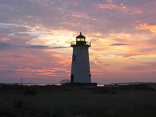
Edgartown Harbor Light is a lighthouse located in Edgartown, Massachusetts, United States, where it marks the entrance to Edgartown Harbor and Katama Bay. It is one of five lighthouses on the island of Martha's Vineyard. The first lighthouse, a two-story wooden structure that also served as the keeper's house, was constructed in 1828. It was demolished, and replaced by the current cast-iron tower, in 1939. Originally located on an artificial island 1/4 miles from shore, the lighthouse is now surrounded by a beach formed, since 1939, by sand accumulating around the stone causeway connecting it to the mainland.

The Harbor Beach Lighthouse is a "sparkplug lighthouse" located at the end of the north breakwall entrance to the harbor of refuge on Lake Huron. The breakwall and light were created by the United States Army Corps of Engineers to protect the harbor of Harbor Beach, Michigan, which is the largest man-made freshwater harbor in the world. Harbor Beach is located on the eastern edge of the Thumb of Huron County, in the state of Michigan.

The Fort Point Light, or Fort Point Light Station, is located in Fort Point State Park, in Stockton Springs, Maine. A lighthouse at this point has served as an active aid to navigation since 1835; the present lighthouse dates to 1857, and is listed on the National Register of Historic Places.

Long Point Light Station is a historic lighthouse at the northeast tip of Long Point in Provincetown, Massachusetts. As a navigational aid, it marks the southwest edge of the entrance to Provincetown Harbor. The United States Coast Guard Light List describes it simply as a "white square tower". The light it casts is green, occulting every 4 seconds, and, at a focal height of 35.5 feet (10.8 m) above mean sea level, has a visible range of 8 nautical miles. When the weather affords low-visibility, one can hear the station's fog horn – sounding a single blast for two seconds, and repeating every 15 seconds – as it seems to call out for its nearly-identical closest neighbor, the Wood End Light.

The Tarpaulin Cove Light is a historic lighthouse on Naushon Island, one of the Elizabeth Islands of southern Massachusetts. It is located in the town of Gosnold, Massachusetts. Built on the site of a light station first established privately in the 18th century, the current tower dates from 1891. A keeper's house built at the same time has not survived. The light is 78 feet (24 m) above Mean High Water, and its white light is visible for 9 nautical miles.

Palmer Island Light Station is a historic lighthouse in New Bedford Harbor in New Bedford, Massachusetts, USA. The lighthouse was built in 1849 out of stone rubble. It was discontinued when the harbor's hurricane barrier was built in the early 1960s, as its location immediately north of the barrier was no longer an outlying danger and there are lights on either side of the barrier opening.

Borden Flats Light is a historic lighthouse on the Taunton River in Fall River, Massachusetts, US. It is a tower-on-caisson type known as a sparkplug lighthouse.

Bird Island Light is a historic lighthouse at the entrance to Sippican Harbor in Marion, Massachusetts. Built in 1819, its tower is a well-preserved example of an early 19th-century masonry lighthouse. The tower and the island on which it stands were added to the National Register of Historic Places as Bird Island Light on September 28, 1987.
Latimer Reef Light is a sparkplug lighthouse on Latimer's Reef in Fishers Island Sound. The lighthouse is located one mile northwest of East Point on Fisher's Island, Suffolk County, New York. Originally called Latemore's Reef after James Latemore.

The Clarks Point Light is located in New Bedford, Massachusetts. Originally constructed as a wooden tower, it was replaced with a stone tower in 1804. This in turn was replaced by a structure on the parapets of Fort Rodman which was deactivated in 1898. After restoration in the early 1970s, it was relit again in 2001 by the city as a private aid.

Egg Rock Light is a lighthouse on Frenchman Bay, Maine. Built in 1875, it is one of coastal Maine's architecturally unique lighthouses, with a square tower projecting through the square keeper's house. Located on Egg Rock, midway between Mount Desert Island and the Schoodic Peninsula, it is an active aid to navigation, flashing red every 40 seconds. The light was listed on the National Register of Historic Places as Egg Rock Light Station in 1988.

Heron Neck Light is a lighthouse on Green's Island in Vinalhaven, Maine at the south end of Penobscot Bay. It was established in 1854 as an aid to navigation for Vinalhaven's main port, and for the Hurricane Channel extending northwest from Heron's Neck. The light was automated in 1984. It was listed on the National Register of Historic Places as Heron Neck Light Station on January 21, 1988.

The Keweenaw Waterway Lower Entrance Light, also known as the Portage Entry Light, is a lighthouse located at the south end of breakwater at mouth of the Portage River in Torch Lake Township. It was listed on the National Register of Historic Places in 2014.


