
The Nathan and Mary (Polly) Johnson properties are a National Historic Landmark at 17–19 and 21 Seventh Street in New Bedford, Massachusetts. Originally two structures, one dating to the 1820s and an 1857 house joined with the older one shortly after construction. They have since been restored and now house the New Bedford Historical Society. The two properties are significant for their association with leading members of the abolitionist movement in Massachusetts, and as the only surviving residence in New Bedford of Frederick Douglass. Nathan and Polly Johnson were free African-Americans who are known to have sheltered escaped slaves using the Underground Railroad from 1822 on. Both were also successful in local business; Nathan as a [caterer] and Polly as a confectioner.

The New Bedford Historic District is a National Historic Landmark District in New Bedford, Massachusetts, United States, west of the community's waterfront. During the 19th century, when the city was the center of the American whaling industry, this was its downtown. After its decline in the early and mid-20th century, through the efforts of local activist groups the district has since been preserved and restored to appear much as it was during that period.
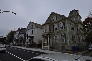
The North Bedford Historic District is a historic district roughly bounded by Summer, Parker, Pleasant and Kempton Streets in New Bedford, Massachusetts. It encompasses a predominantly residential neighborhood north of downtown New Bedford which was developed primarily in the mid 19th-century. It features a variety of worker housing of the period, as well as a number of higher quality houses built by businessmen. The district was added to the National Register of Historic Places in 1979.

The New Bedford Gas and Edison Light Complex is a historic district at 180 MacArthur Drive in New Bedford, Massachusetts. It consists of two buildings: a power generation facility that served the New Bedford area for most of the 20th century, and a historic 19th century iron foundry building. Both are on a property once owned by NSTAR, the local electric utility, on the New Bedford waterfront. The foundry building is a utilitarian three story structure built out of granite, which was built in 1856 for the Taber & Grinnell Iron Foundry. The Cannon Power Station, in contrast, is a looming presence on the waterfront, about 390 feet (120 m) long and more than 80 feet (24 m) in height. Its initial construction was in 1916, and it was repeatedly enlarged until 1950. It was built by the New Bedford Gas & Electric Light District, and generated power for the city until 1992. In 2002 it was under consideration for use as an aquarium; but these plans failed. The complex was vacant in 2012.

The Acushnet Heights Historic District is a predominantly residential historic district in central New Bedford, Massachusetts. It encompasses a densely-built urban area about 20 acres (8.1 ha) in size, which was developed as a working-class area, beginning in the 1860s, for the many workers in the city's factories. The district was listed on the National Register of Historic Places in 1989. It abuts the North Bedford Historic District, which is just to the south, and includes the following separately-listed properties: the Union Street Railway Carbarn, the Bradford Smith Building, and the Dawson Building.

The Central New Bedford Historic District is one of nine historic districts in New Bedford, Massachusetts, United States. The district encompasses the city's central business district, built up during the time in the late 19th century when textiles had replaced whaling as the city's main industry. It is a 29-acre (12 ha) rectangular area bounded by Acushnet Avenue and the older New Bedford Historic District on the east, School Street to the south, Middle Street on the north and 6th Street in the west. It was added to the National Register of Historic Places in 1980.
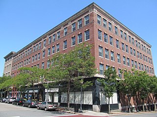
The Times and Olympia Buildings are a pair of historic buildings in central New Bedford, Massachusetts. The Times Building, also known as the Slocum or Evans Building, stands at 908–912 Purchase Street, and was built in 1897 to a design by Nat. C. Smith. Originally a furniture store, it was home to the New Bedford Times until the 1950s. The Olympia Building stands next door; it was designed by Mowll & Rand of Boston and built in 1921. It is a fourstory brick building, with shops on the ground floor and offices above.

The Whitman Mills are a historic mill complex on the banks of the Acushnet River north of central New Bedford, Massachusetts. The mill yard is bounded by Riverside Street, Manomnet Street, Coffin Street, and the river. It is just one of a group of mill complexes developed by William Whitman in the area around the turn of the 20th century. This particular grouping, including two large mills, an office, and several outbuildings, was built between 1896 and 1917, with most of those original buildings still standing. The mills operated until 1932, when the Whitman Company went bankrupt. The complex was nearly demolished in the 1950s, but has since been subdivided and occupied by a succession of smaller businesses.

The Union Street Railway Carbarn, Repair Shop is a historic transit maintenance facility at 1959 Purchase Street in New Bedford, Massachusetts. Built in 1910, the carbarn was the center of the New Bedford's streetcar network, which operated from 1872 to 1947. The carbarn is a large single-story brick building, occupying nearly half of a city block. The adjacent repair shop building, a single-story brick-and-wood building, was built in 1897; it was demolished sometime between 1978 and 2003.

The Bradford Smith Building was a historic building at 1927–1941 Purchase Street in New Bedford, Massachusetts. It was a 3+1⁄2-story wood-frame structure, with a double-gabled roof and a stone-and-brick foundation. It was built in 1887 by Bradford Smith, a retired employee of the Taunton-New Bedford Copper Company, and housed retail space on the first floor and apartments above.
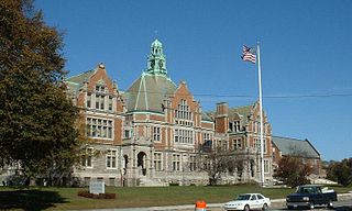
Fairhaven High School and Academy is a public high school in Fairhaven, Massachusetts, United States. Its main building, built in 1905, is known as the "Castle on the Hill" and it is part of the Fairhaven Public Schools district. The school was voted the "most beautiful high school in Massachusetts" in 2017.

Buttonwood Park Historic District is a historic district on Kempton Street, Rockdale Avenue, Hawthorne Street and Brownell Avenue in New Bedford, Massachusetts. Its focal point is Buttonwood Park, a 97-acre (39 ha) municipal park planned by Charles Eliot in the 1890s, and part of its surrounding neighborhood. The neighborhood was developed in the first decades of the 20th century as a complement to the park, and contains a fine selection of Colonial Revival and Craftsman style houses. The district was added to the National Register of Historic Places in 2000.

The Thomas Donaghy School is a historic school building at 68 South Street in New Bedford, Massachusetts. It is a two-story brick structure, roughly rectangular in shape, with a truncated hip roof pierced by hip roof dormers. Sections project on the eastern and western facades of the building. The Romanesque Revival-style school was designed by locally prominent architect Samuel C. Hunt, and built in 1905. It is the city's oldest surviving "modern" school building.

The West School is a historic school building at 106 Bedford Street in Burlington, Massachusetts. The one-room schoolhouse was built in 1794–5, when the area was still part of Woburn. The building was originally located in what is now Simonds Park in the center of Burlington, but was moved to its present location in 1839 to serve as the school for the western part of town. It served as a public school at 1897. After serving for a time as a garage, the building was rehabilitated by the local historical society in 1964. Of four Woburn-built 18th century school buildings in Burlington, this is the only one to survive. The building is a well-preserved example of Federal and Greek Revival styling.
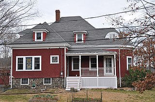
The House at 2 Nichols Street in Wakefield, Massachusetts, is a well-preserved, architecturally eclectic house built in the 1890s. The 1+1⁄2-story frame house has elements of the Tudor Revival, Queen Anne, and Shingle styles, and is one of two identical houses built by local builder Berndt Heurlin. It has a hip roof, but transverse gables, one of which has a rounded bay, giving it a Queen Anne feel. The foundation exterior is fieldstone, and there are several stained glass windows.

The United States Customhouse is a historic and active custom house at 2nd and William Streets in New Bedford, Massachusetts. Architect Robert Mills designed the custom house in 1834 in a Greek Revival style. It has been used by the U.S. Customs Service ever since, and today serves as a port of entry.

Union Baptist Church is a historic church at 109 Court Street in New Bedford, Massachusetts, USA. It was built in 1899 to a design by Nathaniel Cannon Smith in Shingle Style architecture. The congregation was founded in 1895 by a merger of two African American congregations that had split some four decades earlier. This historical church group was a leading New Bedford institution associated with the assistance of fugitive slaves in the pre-Civil War period.

The Head of the River Historic District is a historic district encompassing a village area at the head of navigation of the Acushnet River, which separates Acushnet and New Bedford, Massachusetts. The village is centered at the junction of Tarkin Hill Road, River Road, and Mill Road in New Bedford, and Main Street in Acushnet. The area went through two significant periods of development: the first was in the late 18th and early 19th century, and the second was in the early 20th century. The district was listed on the National Register of Historic Places in 2009.

The Robert C. Ingraham School is a historic school building at 80 Rivet Street in New Bedford, Massachusetts. The three story brick Romanesque Revival building was built in 1901 to a design by local architect Samuel C. Hunt, who designed several other New Bedford school buildings. It was built on a site previously owned by the Potomska Mill Company and used for mill worker housing, and was named for the first librarian of the New Bedford Free Public Library. The building served the city as an elementary school until 1977, and was used for storage until 1992. From 1992 until 2006 it housed a preschool.

The Manomet Mills are a historic textile mill complex on the north side of New Bedford, Massachusetts. They are located between Riverside Avenue and the Acushnet River, north of Manoment Street and the Whitman Mills. The complex consists of three Classical Revival brick buildings, built between 1903 and 1907. The main building, Mill No. 1, is a 54-bay three story structure that was built in 1903. It is attached to Mill No. 2 (1907), of similar size, by a single story brick structure. The third building is the Mill No. 2 Department Room (1907), a two-story brick building that was originally connected to the other two via overhead bridges, now removed. The mill complex was the main operating site of the Manoment Mill Company, which produced cotton yarn until about 1928. The buildings were sold in that year to the Delaware Rayon Company, which went bankrupt in 1954. Mill No. 2 was then used by the Acushnet Process Company for the manufacture of golf balls, while Mill No. 1 continued to be used for rayon production, a chemically intensive and environmentally hazardous process.


