Climate of New York (state)

Last updated
Koppen climate types of New York, using 1991-2020 climate normals and using -3 degC (27 degF) isotherm to distinguish C and D climate zones. Koppen Climate Types New York.png
Köppen climate types of New York, using 1991-2020 climate normals and using −3 °C (27 °F) isotherm to distinguish C and D climate zones.
Lake effect snow bands over Upstate New York Snowband anim.gif
Lake effect snow bands over Upstate New York

The climate of New York (state) is generally humid continental, while the extreme southeastern portion of the state (New York City and Long Island area) lies in the warmer humid subtropical climate zone. Winter temperatures average below freezing during January and February in much of the state of New York, but several degrees above freezing along the Atlantic coastline, including New York City.

Contents

Seasonally, summer-like conditions prevail from June to early September statewide, while areas in far southern New York and New York City have summer conditions from late May through early-mid October. Cold-air damming east of the Appalachians leads to protracted periods of cloud cover and precipitation east of the range, primarily between the October and April months. Winter-like conditions prevail from November through April in northern New York, and from December through March in southern New York. On average, western New York is much cloudier than points south and east in New York, much of it generated from the Great Lakes. Greenhouse gas emission is low on a per-capita basis when compared to most other states due to the extensive use of mass transit, particularly across New York City. The significant urbanization within New York city has led to an urban heat island, which causes temperatures to be warmer overnight in all seasons.

Annual precipitation is fairly even throughout the year across the state of New York. The Great Lakes region of New York sees the highest annual rain and snow amounts in the state of New York, and heavy lake-effect snow is common in both western and central New York in winter. In the hotter months, large, long-lived complexes of thunderstorms can invade the state from Canada and the Great Lakes, while tropical cyclones can bring rains and winds from the southwest during the summer and fall. Hurricane impacts on the state occur once every 18–19 years, with major hurricane impacts every 70–74 years. An average of ten tornadoes touch down in New York annually. Governors Island, Manhattan, in New York Harbor, is planned to host a US$1 billion research and education center poised to make New York City the global leader in addressing the climate crisis. [1]

Temperatures

A high pressure system in Canada surges the air southward into the oncoming storm system, creating the potential for heavy wintry precipitation anywhere the cold and moist air masses meet, when it is sufficiently cold. ColdAirDamming.png
A high pressure system in Canada surges the air southward into the oncoming storm system, creating the potential for heavy wintry precipitation anywhere the cold and moist air masses meet, when it is sufficiently cold.

The annual average temperature across the state ranges from around 39 °F (4 °C) over the Adirondack Mountains to near 53 °F (12 °C) across the Hudson Valley and Long Island, to around 56 °F (13 °C) within New York City. [2] Weather in New York is heavily influenced by two air masses: a warm, humid one from the southwest and a cold, dry one from the northwest. [3] A cool, humid northeast airflow from the North Atlantic is much less common, and results in a persistent cloud deck with associated precipitation which linger across the region for prolonged periods of time. Temperature differences between the warmer coast and far northern inland sections can exceed 36 degrees Fahrenheit (20 degrees Celsius), with rain near the coast and frozen precipitation, such as sleet and freezing rain, falling inland. Two-thirds of such events occur between November and April. [4] which moves from northeast to southwest.

Unlike the vast majority of the state, New York City features a humid subtropical climate (Koppen Cfa). New York City is an urban heat island, with temperatures 5–7 degrees Fahrenheit (3–4 degrees Celsius) warmer overnight than surrounding areas. In an effort to fight this warming, roofs of buildings are being painted white across the city in an effort to increase the reflection of solar energy, or albedo. [5]

Summer

Summers in New York State significantly vary by region. The summer climate is cooler in the Adirondacks due to higher elevation. The Adirondacks typically experience pleasant dry weather in the summer, with temperatures in the range of 66 °F–73 °F (18–22 °C). Evenings in the Adirondacks are chilly, with temperatures ranging on average between 45 °F–54 °F (7–12 °C). Most of Western New York, Central New York, the mid-Hudson Valley and the Catskills have moderate temperatures but are usually humid, with temperatures ranging 80 °F–85 °F (26–29 °C). [3]

Nights in central New York state are often muggy, between 61 °F–67 °F (16–19 °C). The New York City area and the Lower Hudson Valley in contrast feature more sultry and tropical summers with frequent bouts of high temperatures and high dew points. Temperatures in this area are usually between 86 °F–91 °F but slightly cooler by the ocean and south-facing shorelines of Long Island and the temperatures there are between 85–90 °F. Nights are warm and muggy, between 68–75 °F (20–23 °C). The record high for New York state is 108 °F (42 °C), set at Troy on July 22, 1926. [3]

Heat waves

Heat waves are common in New York State which bring high heat and humidity. Heat waves occurs at least two times each summer and are an average of 3–5 days . [6] Only the Adirondacks does not see oppressive temperatures during most heat waves in New York State. The Adirondacks have warm to hot temperatures with some humidity during a heat wave but it is typically cooler than the rest of the state during a heat wave.

Winter snowfall

Snowfall in New York State also significantly varies by region. Lake-effect snow takes place in Western New York and the Adirondacks with Lake Ontario and Lake Erie. Lake-effect snow is very localized and areas may see feet of snow while others see only an inch or none at all. The Adirondacks see the most snowfall because of lake-effect snowfall and higher elevations which see between 100–200 inches per year and some may see more than 200 inches per year, especially western parts of the Adirondacks.

Western and Central New York see between 75–150 inches per year depending on your location and where the bands hit. The Catskills see an average snowfall, between 25–50 inches and most of it is from nor-easters which are almost always snow. New York City, Long Island, and the Hudson Valley see the least amount of snowfall because they see warmer temperatures from the warmer ocean temperatures and the nor-easters there are mixed with rain, between 10–25 inches.

Winter temperatures

A rare late-season snowfall on May 9, 2010 in Ontario County, Rochester NY MSA Mid May snowfall in Rochester MSA.jpg
A rare late-season snowfall on May 9, 2010 in Ontario County, Rochester NY MSA
Snow in the same location 10 years later on May 9, 2020 May 9th 2020 Western New York snowfall.jpg
Snow in the same location 10 years later on May 9, 2020

Winter temps vary just like the summer temperatures. The Adirondacks are the coldest in New York and are almost always below freezing for almost 3 straight months. The temps are between 18–23 °F (−7 to −5 °C). Nights are cold and frigid, between −2 and 4 °F (−18 to −15 °C). Most of Central New York, Mid Hudson Valley, and the Catskills have moderate temperatures that are not very cold but not mild, Between 30–35 °F (−1 to 1 °C). Nights are cold but not frigid, between 18–23 °F (−7 to −5 °C). [3]

New York City, Hudson Valley, and Long Island are the warmest in New York State because of warmer ocean temperatures which keep these area between 37–42 °F (2 to 5 °C), warmer than locations upstate. Downstate nights typically range between 27–31 °F. The record low for New York state is −52 °F (−47 °C), set at Stillwater Reservoir on February 9, 1934 and at Old Forge on February 18, 1979. [3] In February 2015, Rochester experienced its coldest month ever, with an average temperature of 12.2 °F (−11 °C). [7] Later, 2015 had a near-record warm November and a record-breaking December. December 2015 was about 12 degrees F warmer than average, and several degrees over the previous record. [8]

Records

EventMeasurementDateLocationCounty
Highest temperature [9] 108 °F (42.2 °C)July 22, 1926 Troy Rensselaer
Lowest temperature [9] −52 °F (−46.7 °C)February 18, 1979 Old Forge Herkimer
Lowest temperature [3] −52 °F (−46.7 °C)February 9, 1934 Stillwater Reservoir Herkimer

Plant hardiness growing zones

New York State growing seasons have significant variations depending on the region. The Adirondacks, which encompasses hardiness zones 3 to 4, have the shortest growing season. Central New York, Western New York, the Catskills, and Mid-Hudson Valley encompass growing zones 5 to 6 and have much longer growing seasons and therefore more agriculture. Lower Hudson Valley, New York City, and Long Island, in growing zones 6 to 7, have the longest growing season in the state, and some areas of New York City, encompass growing zone 8, with it being due to the impact of the Atlantic and the urban heat island effect.

Cloudiness

Southeastern sections of the state near New York City have an average annual cloud cover of 59-62%, while areas of western New York around Buffalo average 71–75% cloud cover annually. [10]

Precipitation

The annual average precipitation for New York state NYrainfall.png
The annual average precipitation for New York state

Average precipitation across the region show maxima within the mountains of the Appalachians. Between 28 inches (710 mm) and 62 inches (1,600 mm) of precipitation falls annually across the Northeastern United States, [11] and New York's averages are similar, with maxima of over 60 inches (1,500 mm) falling across southwestern Lewis County, northern Oneida County, central and southern Hamilton County, as well as northwestern Ulster County. The lowest amounts occur near the northern borders with Vermont and Ontario, as well as much of southwestern sections of the state. [12] Temporally, a maximum in precipitation is seen around three peak times: 3 a.m., 10 a.m., and 6 p.m. During the summer, the 6 p.m. peak is most pronounced. [13]

Mean annual snowfall (in inches) for Upstate New York, using 1991-2020 climate normals. Snowfall is especially prevalent within the lake-effect snowbelts of western and north central New York. Snowfall Climatology Upstate New York.png
Mean annual snowfall (in inches) for Upstate New York, using 1991-2020 climate normals. Snowfall is especially prevalent within the lake-effect snowbelts of western and north central New York.

Coastal extratropical cyclones, known as nor'easters, bring a bulk of the wintry precipitation to the region during the cold season as they track parallel to the coastline, forming along the natural temperature gradient of the Gulf Stream before moving up the coastline. [14] The Appalachian Mountains largely shield New York City from picking up any lake-effect snow, [15] which develops in the wake of extratropical cyclones downwind of the Great Lakes. The Finger Lakes of New York are long enough for lake-effect precipitation. Lake-effect snow from the Finger Lakes (like elsewhere) occurs in upstate New York until those lakes freeze over. [16] Annual average lake-effect snows exceed 150 inches (380 cm) downwind of Lake Erie and 200 inches (510 cm) downwind of Lake Ontario. [17]

During the summer and early fall, mesoscale convective systems can move into the area from Canada and the Great Lakes. Tropical cyclones and their remains occasionally move into the region from the south and southwest. [18] The region has experienced a couple heavy rainfall events that exceeded the 50-year return period, during October 1996 and October 1998, which suggest an increase in heavy rainfall along the coast. [19]

Records

EventMeasurementDateLocationCounty
Greatest 24-hour precipitation [9] 13.57 inches (345 mm)August 12–13, 2014 Islip Suffolk
Greatest 24-hour snowfall [lower-alpha 1] [20] 50 inches (130 cm)January 31, 1966 Camden Oneida
Greatest snow depth [9] 119 inches (300 cm)April 20, 1943 Whiteface Mountain Essex County

Air pollution

In terms of emissions, New York ranks 46th among the 50 states in the amount of greenhouse gases generated per person. This efficiency is primarily due to the state's higher rate of mass transit use in and around New York City. [21]

However, New York City (particularly Manhattan) has extremely high rates of air pollution, with high particle pollution [22] and high cancer rates, [23] which can be explained by extreme population density, despite low per-capita emissions rates.

Severe weather

New York experiences an average of ten tornadoes per year, [24] with one tornado every five years considered strong or violent (EF2-EF5). [25] The return period for hurricane impacts on the state is 18–19 years, [26] with major hurricane return periods between 70–74 years. [27] In 2016, much of New York experienced a severe drought, including the Finger Lakes region, where the drought was preceded by a very mild winter with minimal snow pack.

Climate data for select cities

Climate data for Albany International Airport, New York (1991–2020 normals, [lower-alpha 2] extremes 1874–present [lower-alpha 3] )
MonthJanFebMarAprMayJunJulAugSepOctNovDecYear
Record high °F (°C)71
(22)
74
(23)
89
(32)
93
(34)
97
(36)
100
(38)
104
(40)
102
(39)
100
(38)
91
(33)
82
(28)
72
(22)
104
(40)
Mean maximum °F (°C)54.5
(12.5)
54.5
(12.5)
65.9
(18.8)
80.9
(27.2)
87.8
(31.0)
92.0
(33.3)
92.7
(33.7)
90.6
(32.6)
87.0
(30.6)
77.8
(25.4)
67.7
(19.8)
56.4
(13.6)
94.5
(34.7)
Mean daily maximum °F (°C)32.8
(0.4)
36.0
(2.2)
45.3
(7.4)
59.2
(15.1)
71.2
(21.8)
79.4
(26.3)
83.9
(28.8)
82.0
(27.8)
74.4
(23.6)
61.6
(16.4)
49.3
(9.6)
38.2
(3.4)
59.4
(15.2)
Daily mean °F (°C)24.4
(−4.2)
26.8
(−2.9)
35.7
(2.1)
48.1
(8.9)
59.6
(15.3)
68.4
(20.2)
73.1
(22.8)
71.4
(21.9)
63.5
(17.5)
51.4
(10.8)
40.5
(4.7)
30.4
(−0.9)
49.4
(9.7)
Mean daily minimum °F (°C)15.9
(−8.9)
17.6
(−8.0)
26.1
(−3.3)
36.9
(2.7)
48.1
(8.9)
57.4
(14.1)
62.4
(16.9)
60.7
(15.9)
52.6
(11.4)
41.1
(5.1)
31.6
(−0.2)
22.7
(−5.2)
39.4
(4.1)
Mean minimum °F (°C)−6.0
(−21.1)
−2.4
(−19.1)
7.8
(−13.4)
23.7
(−4.6)
33.8
(1.0)
43.3
(6.3)
51.5
(10.8)
48.9
(9.4)
37.6
(3.1)
27.0
(−2.8)
16.0
(−8.9)
4.6
(−15.2)
−8.4
(−22.4)
Record low °F (°C)−28
(−33)
−22
(−30)
−21
(−29)
9
(−13)
26
(−3)
35
(2)
40
(4)
34
(1)
24
(−4)
16
(−9)
−11
(−24)
−22
(−30)
−28
(−33)
Average precipitation inches (mm)2.60
(66)
2.28
(58)
3.09
(78)
3.11
(79)
3.41
(87)
4.05
(103)
4.55
(116)
3.76
(96)
3.73
(95)
3.85
(98)
2.99
(76)
3.26
(83)
40.68
(1,033)
Average snowfall inches (cm)15.6
(40)
13.7
(35)
12.0
(30)
1.6
(4.1)
0.1
(0.25)
0.0
(0.0)
0.0
(0.0)
0.0
(0.0)
0.0
(0.0)
0.3
(0.76)
2.6
(6.6)
13.3
(34)
59.2
(150)
Average precipitation days (≥ 0.01 in)12.710.611.812.212.712.211.411.09.711.211.112.6139.2
Average snowy days (≥ 0.1 in)10.17.85.71.30.00.00.00.00.00.22.47.034.5
Average relative humidity (%)71.168.564.861.265.569.570.574.175.772.473.173.970.0
Average dew point °F (°C)12.9
(−10.6)
14.5
(−9.7)
22.6
(−5.2)
32.2
(0.1)
45.0
(7.2)
55.0
(12.8)
60.3
(15.7)
59.4
(15.2)
52.3
(11.3)
40.3
(4.6)
31.1
(−0.5)
19.4
(−7.0)
37.1
(2.8)
Mean monthly sunshine hours 141.1158.5200.3218.9248.9262.2289.2253.2210.5168.8100.7108.32,360.6
Percent possible sunshine 48545454555762595649343853
Average ultraviolet index 1245788763215
Source 1: NOAA (relative humidity, dew point, and sun 1961–1990) [28] [29] [30]
Source 2: Weather Atlas [31]
Climate data for Buffalo (Buffalo Niagara International Airport), 1991–2020 normals, [lower-alpha 4] extremes 1871–present [lower-alpha 5]
MonthJanFebMarAprMayJunJulAugSepOctNovDecYear
Record high °F (°C)72
(22)
71
(22)
82
(28)
94
(34)
94
(34)
97
(36)
98
(37)
99
(37)
98
(37)
92
(33)
80
(27)
74
(23)
99
(37)
Mean maximum °F (°C)56.4
(13.6)
54.5
(12.5)
66.0
(18.9)
77.9
(25.5)
84.3
(29.1)
88.1
(31.2)
89.5
(31.9)
88.5
(31.4)
86.4
(30.2)
77.9
(25.5)
67.4
(19.7)
56.8
(13.8)
91.5
(33.1)
Mean daily maximum °F (°C)32.1
(0.1)
33.3
(0.7)
41.8
(5.4)
54.7
(12.6)
67.4
(19.7)
75.6
(24.2)
80.2
(26.8)
79.0
(26.1)
72.3
(22.4)
59.6
(15.3)
47.8
(8.8)
37.2
(2.9)
56.8
(13.8)
Daily mean °F (°C)25.5
(−3.6)
26.4
(−3.1)
34.1
(1.2)
45.6
(7.6)
57.9
(14.4)
66.9
(19.4)
71.7
(22.1)
70.4
(21.3)
63.4
(17.4)
51.7
(10.9)
41.0
(5.0)
31.4
(−0.3)
48.8
(9.3)
Mean daily minimum °F (°C)19.0
(−7.2)
19.5
(−6.9)
26.4
(−3.1)
36.5
(2.5)
48.3
(9.1)
58.1
(14.5)
63.1
(17.3)
61.7
(16.5)
54.5
(12.5)
43.9
(6.6)
34.2
(1.2)
25.6
(−3.6)
40.9
(4.9)
Mean minimum °F (°C)0.8
(−17.3)
1.7
(−16.8)
9.3
(−12.6)
24.6
(−4.1)
35.6
(2.0)
45.6
(7.6)
52.8
(11.6)
51.0
(10.6)
41.0
(5.0)
30.7
(−0.7)
20.4
(−6.4)
8.5
(−13.1)
−2.8
(−19.3)
Record low °F (°C)−16
(−27)
−20
(−29)
−7
(−22)
5
(−15)
25
(−4)
35
(2)
43
(6)
38
(3)
32
(0)
20
(−7)
2
(−17)
−10
(−23)
−20
(−29)
Average precipitation inches (mm)3.35
(85)
2.49
(63)
2.89
(73)
3.37
(86)
3.37
(86)
3.37
(86)
3.23
(82)
3.23
(82)
4.10
(104)
4.03
(102)
3.50
(89)
3.75
(95)
40.68
(1,033)
Average snowfall inches (cm)26.7
(68)
18.1
(46)
14.1
(36)
2.5
(6.4)
0.0
(0.0)
0.0
(0.0)
0.0
(0.0)
0.0
(0.0)
0.0
(0.0)
0.9
(2.3)
7.8
(20)
25.3
(64)
95.4
(242)
Average extreme snow depth inches (cm)10.8
(27)
8.4
(21)
7.6
(19)
1.0
(2.5)
0.0
(0.0)
0.0
(0.0)
0.0
(0.0)
0.0
(0.0)
0.0
(0.0)
0.1
(0.25)
3.7
(9.4)
9.0
(23)
15.5
(39)
Average precipitation days (≥ 0.01 in)19.215.814.813.412.811.910.810.010.914.114.417.7165.8
Average snowy days (≥ 0.1 in)16.413.59.13.20.00.00.00.00.00.44.712.259.5
Average relative humidity (%)76.075.973.367.867.268.668.172.174.072.975.877.672.4
Average dew point °F (°C)16.9
(−8.4)
17.6
(−8.0)
25.2
(−3.8)
33.4
(0.8)
44.2
(6.8)
54.1
(12.3)
59.0
(15.0)
58.8
(14.9)
52.5
(11.4)
41.7
(5.4)
32.7
(0.4)
22.6
(−5.2)
38.2
(3.5)
Mean monthly sunshine hours 91.3108.0163.7204.7258.3287.1306.7266.4207.6159.484.469.02,206.6
Percent possible sunshine 31374451576366625547292549
Average ultraviolet index 1246788864215
Source 1: NOAA (relative humidity and sun 1961–1990) [32] [33] [34]
Source 2: Weather Atlas [35]
Climate data for Islip, New York (Long Island MacArthur Airport), 1991–2020 normals, [lower-alpha 6] extremes 1963–present
MonthJanFebMarAprMayJunJulAugSepOctNovDecYear
Record high °F (°C)69
(21)
71
(22)
82
(28)
94
(34)
98
(37)
96
(36)
104
(40)
100
(38)
94
(34)
89
(32)
80
(27)
77
(25)
104
(40)
Mean maximum °F (°C)58.2
(14.6)
57.1
(13.9)
66.7
(19.3)
77.0
(25.0)
85.8
(29.9)
90.4
(32.4)
94.0
(34.4)
91.2
(32.9)
86.0
(30.0)
78.6
(25.9)
68.8
(20.4)
60.9
(16.1)
95.6
(35.3)
Mean daily maximum °F (°C)39.2
(4.0)
41.0
(5.0)
47.7
(8.7)
58.3
(14.6)
68.3
(20.2)
77.2
(25.1)
82.8
(28.2)
81.4
(27.4)
74.8
(23.8)
64.1
(17.8)
53.6
(12.0)
44.4
(6.9)
61.1
(16.2)
Daily mean °F (°C)31.9
(−0.1)
33.3
(0.7)
39.9
(4.4)
49.7
(9.8)
59.5
(15.3)
69.0
(20.6)
75.0
(23.9)
73.7
(23.2)
66.9
(19.4)
55.7
(13.2)
45.6
(7.6)
37.1
(2.8)
53.1
(11.7)
Mean daily minimum °F (°C)24.6
(−4.1)
25.5
(−3.6)
32.0
(0.0)
41.2
(5.1)
50.8
(10.4)
60.9
(16.1)
67.3
(19.6)
66.0
(18.9)
58.9
(14.9)
47.3
(8.5)
37.6
(3.1)
29.8
(−1.2)
45.2
(7.3)
Mean minimum °F (°C)7.4
(−13.7)
9.8
(−12.3)
17.0
(−8.3)
28.8
(−1.8)
37.9
(3.3)
48.4
(9.1)
57.7
(14.3)
55.7
(13.2)
45.4
(7.4)
33.0
(0.6)
22.9
(−5.1)
15.8
(−9.0)
5.4
(−14.8)
Record low °F (°C)−8
(−22)
−14
(−26)
0
(−18)
16
(−9)
32
(0)
42
(6)
49
(9)
45
(7)
38
(3)
23
(−5)
11
(−12)
−1
(−18)
−14
(−26)
Average precipitation inches (mm)3.66
(93)
3.29
(84)
4.51
(115)
4.06
(103)
3.28
(83)
4.00
(102)
3.26
(83)
4.24
(108)
3.60
(91)
3.97
(101)
3.41
(87)
4.71
(120)
45.99
(1,168)
Average snowfall inches (cm)10.3
(26)
9.4
(24)
6.5
(17)
0.6
(1.5)
0.0
(0.0)
0.0
(0.0)
0.0
(0.0)
0.0
(0.0)
0.0
(0.0)
0.0
(0.0)
0.5
(1.3)
4.5
(11)
31.8
(81)
Average precipitation days (≥ 0.01 in)11.19.910.811.311.610.19.18.98.69.29.611.8122.0
Average snowy days (≥ 0.1 in)3.83.72.70.30.00.00.00.00.00.00.32.613.4
Source: NOAA [36] [37]
MonthJanFebMarAprMayJunJulAugSepOctNovDecYear
Record high °F (°C)72
(22)
78
(26)
86
(30)
96
(36)
99
(37)
101
(38)
106
(41)
104
(40)
102
(39)
94
(34)
84
(29)
75
(24)
106
(41)
Mean maximum °F (°C)60.4
(15.8)
60.7
(15.9)
70.3
(21.3)
82.9
(28.3)
88.5
(31.4)
92.1
(33.4)
95.7
(35.4)
93.4
(34.1)
89.0
(31.7)
79.7
(26.5)
70.7
(21.5)
62.9
(17.2)
97.0
(36.1)
Mean daily maximum °F (°C)39.5
(4.2)
42.2
(5.7)
49.9
(9.9)
61.8
(16.6)
71.4
(21.9)
79.7
(26.5)
84.9
(29.4)
83.3
(28.5)
76.2
(24.6)
64.5
(18.1)
54.0
(12.2)
44.3
(6.8)
62.6
(17.0)
Daily mean °F (°C)33.7
(0.9)
35.9
(2.2)
42.8
(6.0)
53.7
(12.1)
63.2
(17.3)
72.0
(22.2)
77.5
(25.3)
76.1
(24.5)
69.2
(20.7)
57.9
(14.4)
48.0
(8.9)
39.1
(3.9)
55.8
(13.2)
Mean daily minimum °F (°C)27.9
(−2.3)
29.5
(−1.4)
35.8
(2.1)
45.5
(7.5)
55.0
(12.8)
64.4
(18.0)
70.1
(21.2)
68.9
(20.5)
62.3
(16.8)
51.4
(10.8)
42.0
(5.6)
33.8
(1.0)
48.9
(9.4)
Mean minimum °F (°C)9.8
(−12.3)
12.7
(−10.7)
19.7
(−6.8)
32.8
(0.4)
43.9
(6.6)
52.7
(11.5)
61.8
(16.6)
60.3
(15.7)
50.2
(10.1)
38.4
(3.6)
27.7
(−2.4)
18.0
(−7.8)
7.7
(−13.5)
Record low °F (°C)−6
(−21)
−15
(−26)
3
(−16)
12
(−11)
32
(0)
44
(7)
52
(11)
50
(10)
39
(4)
28
(−2)
5
(−15)
−13
(−25)
−15
(−26)
Average precipitation inches (mm)3.64
(92)
3.19
(81)
4.29
(109)
4.09
(104)
3.96
(101)
4.54
(115)
4.60
(117)
4.56
(116)
4.31
(109)
4.38
(111)
3.58
(91)
4.38
(111)
49.52
(1,258)
Average snowfall inches (cm)8.8
(22)
10.1
(26)
5.0
(13)
0.4
(1.0)
0.0
(0.0)
0.0
(0.0)
0.0
(0.0)
0.0
(0.0)
0.0
(0.0)
0.1
(0.25)
0.5
(1.3)
4.9
(12)
29.8
(76)
Average precipitation days (≥ 0.01 in)10.810.011.111.411.511.210.510.08.89.59.211.4125.4
Average snowy days (≥ 0.1 in)3.73.22.00.20.00.00.00.00.00.00.22.111.4
Average relative humidity (%)61.560.258.555.362.765.264.266.067.865.664.664.163.0
Average dew point °F (°C)18.0
(−7.8)
19.0
(−7.2)
25.9
(−3.4)
34.0
(1.1)
47.3
(8.5)
57.4
(14.1)
61.9
(16.6)
62.1
(16.7)
55.6
(13.1)
44.1
(6.7)
34.0
(1.1)
24.6
(−4.1)
40.3
(4.6)
Mean monthly sunshine hours 162.7163.1212.5225.6256.6257.3268.2268.2219.3211.2151.0139.02,534.7
Percent possible sunshine 54555757575759635961514857
Average ultraviolet index 2346788864215
Source 1: NOAA (relative humidity and sun 1961–1990; dew point 1965–1984) [39] [40] [41]
Source 2: Weather Atlas [42]

See Climate of New York City for additional climate information from the outer boroughs.

Sea temperature data for New York [42]
MonthJanFebMarAprMayJunJulAugSepOctNovDecYear
Average sea
temperature °F (°C)
41.7
(5.4)
39.7
(4.3)
40.2
(4.5)
45.1
(7.3)
52.5
(11.4)
64.5
(18.1)
72.1
(22.3)
74.1
(23.4)
70.1
(21.2)
63.0
(17.2)
54.3
(12.4)
47.2
(8.4)
55.4
(13.0)
Climate data for JFK Airport, New York (1991–2020 normals, [lower-alpha 9] extremes 1948–present)
MonthJanFebMarAprMayJunJulAugSepOctNovDecYear
Record high °F (°C)71
(22)
71
(22)
85
(29)
90
(32)
99
(37)
99
(37)
104
(40)
101
(38)
98
(37)
95
(35)
80
(27)
75
(24)
104
(40)
Mean maximum °F (°C)57.7
(14.3)
58.3
(14.6)
67.5
(19.7)
77.9
(25.5)
85.6
(29.8)
92.4
(33.6)
95.2
(35.1)
91.9
(33.3)
87.9
(31.1)
79.7
(26.5)
68.9
(20.5)
60.6
(15.9)
96.8
(36.0)
Mean daily maximum °F (°C)39.5
(4.2)
41.7
(5.4)
48.7
(9.3)
58.8
(14.9)
68.4
(20.2)
78.0
(25.6)
83.6
(28.7)
82.2
(27.9)
75.8
(24.3)
64.7
(18.2)
53.8
(12.1)
44.5
(6.9)
61.6
(16.4)
Daily mean °F (°C)32.8
(0.4)
34.5
(1.4)
41.1
(5.1)
50.9
(10.5)
60.5
(15.8)
70.2
(21.2)
76.1
(24.5)
75.0
(23.9)
68.4
(20.2)
57.2
(14.0)
46.8
(8.2)
38.3
(3.5)
54.3
(12.4)
Mean daily minimum °F (°C)26.2
(−3.2)
27.4
(−2.6)
33.6
(0.9)
42.9
(6.1)
52.5
(11.4)
62.4
(16.9)
68.7
(20.4)
67.8
(19.9)
61.0
(16.1)
49.8
(9.9)
39.8
(4.3)
32.0
(0.0)
47.0
(8.3)
Mean minimum °F (°C)10.2
(−12.1)
13.3
(−10.4)
20.2
(−6.6)
32.6
(0.3)
42.9
(6.1)
52.6
(11.4)
62.8
(17.1)
60.1
(15.6)
50.0
(10.0)
37.9
(3.3)
26.9
(−2.8)
18.6
(−7.4)
8.2
(−13.2)
Record low °F (°C)−2
(−19)
−2
(−19)
7
(−14)
20
(−7)
34
(1)
45
(7)
55
(13)
46
(8)
40
(4)
30
(−1)
15
(−9)
2
(−17)
−2
(−19)
Average precipitation inches (mm)3.23
(82)
2.76
(70)
3.94
(100)
3.55
(90)
3.66
(93)
3.85
(98)
3.86
(98)
4.11
(104)
3.58
(91)
3.72
(94)
3.07
(78)
3.96
(101)
43.29
(1,100)
Average snowfall inches (cm)7.5
(19)
8.6
(22)
4.3
(11)
0.6
(1.5)
0.0
(0.0)
0.0
(0.0)
0.0
(0.0)
0.0
(0.0)
0.0
(0.0)
0.0
(0.0)
0.4
(1.0)
4.5
(11)
25.9
(66)
Average precipitation days (≥ 0.01 inch)10.79.810.811.411.810.69.49.08.29.48.911.2121.2
Average snowy days (≥ 0.1 in)4.63.82.50.30.00.00.00.00.00.00.22.614.0
Average relative humidity (%)64.964.463.464.169.571.571.471.771.969.167.966.368.0
Source: NOAA (relative humidity 1961–1990) [43] [44] [45]
Climate data for Rochester, New York (Greater Rochester Int'l), 1991–2020 normals, [lower-alpha 10] extremes 1871−present [lower-alpha 11]
MonthJanFebMarAprMayJunJulAugSepOctNovDecYear
Record high °F (°C)74
(23)
73
(23)
86
(30)
93
(34)
94
(34)
100
(38)
102
(39)
99
(37)
99
(37)
91
(33)
81
(27)
72
(22)
102
(39)
Mean maximum °F (°C)57.2
(14.0)
55.1
(12.8)
67.1
(19.5)
79.9
(26.6)
86.7
(30.4)
90.5
(32.5)
92.1
(33.4)
90.4
(32.4)
87.7
(30.9)
80.0
(26.7)
68.5
(20.3)
57.5
(14.2)
93.4
(34.1)
Mean daily maximum °F (°C)33.4
(0.8)
35.2
(1.8)
43.6
(6.4)
55.5
(13.1)
69.4
(20.8)
77.9
(25.5)
82.5
(28.1)
80.5
(26.9)
73.6
(23.1)
61.2
(16.2)
49.1
(9.5)
38.5
(3.6)
58.5
(14.7)
Daily mean °F (°C)26.2
(−3.2)
27.4
(−2.6)
35.2
(1.8)
46.8
(8.2)
58.8
(14.9)
67.6
(19.8)
72.3
(22.4)
70.7
(21.5)
63.6
(17.6)
52.2
(11.2)
41.5
(5.3)
32.0
(0.0)
49.5
(9.7)
Mean daily minimum °F (°C)19.0
(−7.2)
19.6
(−6.9)
26.8
(−2.9)
37.1
(2.8)
48.2
(9.0)
57.4
(14.1)
62.2
(16.8)
61.0
(16.1)
53.6
(12.0)
43.3
(6.3)
34.0
(1.1)
25.4
(−3.7)
40.6
(4.8)
Mean minimum °F (°C)−0.8
(−18.2)
0.5
(−17.5)
8.4
(−13.1)
24.1
(−4.4)
34.4
(1.3)
43.9
(6.6)
50.7
(10.4)
49.2
(9.6)
39.6
(4.2)
29.7
(−1.3)
18.6
(−7.4)
7.7
(−13.5)
−3.7
(−19.8)
Record low °F (°C)−17
(−27)
−22
(−30)
−9
(−23)
7
(−14)
26
(−3)
35
(2)
42
(6)
36
(2)
28
(−2)
19
(−7)
1
(−17)
−16
(−27)
−22
(−30)
Average precipitation inches (mm)2.55
(65)
2.13
(54)
2.49
(63)
2.99
(76)
2.86
(73)
3.37
(86)
3.56
(90)
3.31
(84)
3.18
(81)
3.22
(82)
2.76
(70)
2.67
(68)
35.09
(891)
Average snowfall inches (cm)27.4
(70)
23.1
(59)
17.9
(45)
3.0
(7.6)
0.1
(0.25)
0.0
(0.0)
0.0
(0.0)
0.0
(0.0)
0.0
(0.0)
0.1
(0.25)
8.1
(21)
22.3
(57)
102.0
(259)
Average precipitation days (≥ 0.01 in)19.616.415.413.412.411.511.210.311.113.914.918.1168.2
Average snowy days (≥ 0.1 in)17.615.010.13.00.10.00.00.00.00.25.713.565.2
Average relative humidity (%)74.074.171.067.067.269.469.774.376.874.576.377.572.6
Average dew point °F (°C)16.3
(−8.7)
17.2
(−8.2)
25.0
(−3.9)
34.0
(1.1)
45.1
(7.3)
55.0
(12.8)
59.9
(15.5)
59.7
(15.4)
53.4
(11.9)
42.3
(5.7)
33.3
(0.7)
22.8
(−5.1)
38.7
(3.7)
Mean monthly sunshine hours 108.3118.1177.7216.5266.5297.6314.4273.4212.3154.481.577.52,298.2
Percent possible sunshine 37404854596568635745282852
Source: NOAA (relative humidity, dew point, and sun 1961–1990) [46] [47] [48]

See also

Related Research Articles

<span class="mw-page-title-main">Climate of Missouri</span> Overview of the climate of Missouri, United States

Missouri generally has a variety of seasonal humid subtropical climate, with cool winters and long, hot summers. In the southern part of the state, particularly in the Bootheel, the climate borders on a more mild-type humid subtropical climate, and in the northern third, the state transitions into a humid continental climate. Because of its location in the interior United States, Missouri often experiences extremes in temperatures. Lacking either large mountains or oceans nearby to moderate its temperature, its climate is alternately influenced by air from the cold Arctic and the hot and humid Gulf of Mexico.

<span class="mw-page-title-main">Climate of Virginia</span> Overview of the climate of the U.S. state of Virginia

The climate of Virginia, a state on the east coast of the United States, is considered mild compared to more northern areas of the United States such as New England and the Midwest. Most of Virginia east of the Blue Ridge mountains, the southern part of the Shenandoah Valley, and the Roanoke Valley, has a humid subtropical climate. In the mountainous areas west of the Blue Ridge, the climate is warm-summer humid continental or oceanic climate. Severe weather, in the form of tornadoes, tropical cyclones, and winter storms, impacts the state on a regular basis. Central Virginia received significant snowfall of 20 inches in December 2009.

The climate of Salt Lake City, Utah features cold and snowy winters, hot and dry summers, and modest to light seasonal rainfall. Lying in the Salt Lake Valley, the city is surrounded by mountains and the Great Salt Lake. Under the Köppen climate classification, Salt Lake City has either a Mediterranean climate (Csa) or dry-summer continental climate (Dsa) depending on which variant of the system is used, though it borders on a cold semi-arid climate (BSk) due to the city's relatively low precipitation.

The climate of Bismarck in the U.S. state of North Dakota is humid continental, caused primarily by the combination of its mid-level latitude and location not far from the geographic centre of the U.S. Its summers are hot enough for it to border on having a Köppen Dwa classification, and precipitation is high enough for it to barely avoid being classified as semi-arid. The city's climate displays four very distinct seasons and great variation in temperatures over very short periods of time. Like other cities in the northern Great Plains, its climate is also fairly dry.

Milwaukee has a humid continental climate, with four distinct seasons and wide variations in temperature and precipitation in short periods of time. The city's climate is also strongly influenced by nearby Lake Michigan, which creates two varying climates within the Milwaukee area. The Urban heat island effect also plays a role in the city's climate, insulating it from winter cold, but keeping it cooler in spring and summer.

<span class="mw-page-title-main">Climate of Minnesota</span> Climatic conditions of Minnesota, US

Minnesota has a humid continental climate, with hot summers and cold winters. Minnesota's location in the Upper Midwest allows it to experience some of the widest variety of weather in the United States, with each of the four seasons having its own distinct characteristics. The area near Lake Superior in the Minnesota Arrowhead region experiences weather unique from the rest of the state. The moderating effect of Lake Superior keeps the surrounding area relatively cooler in the summer and warmer in the winter, giving that region a smaller yearly temperature variation. On the Köppen climate classification, much of the southern third of Minnesota—roughly from the Twin Cities region southward—falls in the hot summer zone (Dfa), and the northern two-thirds of Minnesota falls in the warm summer zone (Dfb).

<span class="mw-page-title-main">Climate of California</span> Overview of the climate of the U.S. state of California

The climate of California varies widely from hot desert to alpine tundra, depending on latitude, elevation, and proximity to the Pacific Coast. California's coastal regions, the Sierra Nevada foothills, and much of the Central Valley have a Mediterranean climate, with warmer, drier weather in summer and cooler, wetter weather in winter. The influence of the ocean generally moderates temperature extremes, creating warmer winters and substantially cooler summers in coastal areas.

The Climate of Grand Forks, North Dakota is a warm summer continental typical of cities located in the Great Plains, with four very distinct seasons and great variation in temperatures over very short periods of time. The city's climate is characterized by long, cold winters with moderate snowfall and warm summers which are typically humid.

<span class="mw-page-title-main">Climate of North Dakota</span>

North Dakota's climate is typical of a continental climate with cold winters and warm-hot summers. The state's location in the Upper Midwest allows it to experience some of the widest variety of weather in the United States, and each of the four seasons has its own distinct characteristics. The eastern half of the state has a humid continental climate with warm to hot, somewhat humid summers and cold, windy winters, while the western half has a semi-arid climate with less precipitation and less humidity but similar temperature profiles. The areas east of the Missouri River get slightly colder winters, while those west of the stream get higher summer daytime temperatures. In general, the diurnal temperature difference is prone to be more significant in the west due to higher elevation and less humidity.

<span class="mw-page-title-main">Climate of Georgia (U.S. state)</span> Overview of the climate of the U.S. state of Georgia

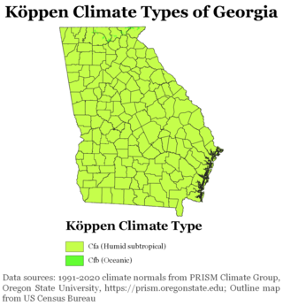
The climate of Georgia is a humid subtropical climate, with most of the state having short, mild winters and long, hot summers. The Atlantic Ocean on the east coast of Georgia and the hill country in the north impact the state's climate. Also, the Chattahoochee River divides Georgia into separate climatic regions with the mountain region to the northwest being cooler than the rest of the state; the average temperatures for the mountain region in January and July are 39 °F (4 °C) and 78 °F (26 °C) respectively. Winter in Georgia is characterized by mild temperatures and little snowfall around the state, with the potential for snow and ice increasing in the northern parts of the state. Summer daytime temperatures in Georgia often exceed 95 °F (35 °C). The state experiences widespread precipitation. Tornadoes and tropical cyclones are common.

<span class="mw-page-title-main">Climate of North Carolina</span> Overview of the climate of the U.S. state of North Carolina

North Carolina's climate varies from the Atlantic coast in the east to the Appalachian Mountain range in the west. The mountains often act as a "shield", blocking low temperatures and storms from the Midwest from entering the Piedmont of North Carolina.

<span class="mw-page-title-main">Climate of Pennsylvania</span> Overview of the climate of the U.S. state of Pennsylvania

The climate of Pennsylvania is diverse due to the multitude of geographic features found within the state. Straddling two major climate zones, the southeastern corner of Pennsylvania has the warmest climate. A portion of Greater Philadelphia lies at the southernmost tip of the humid continental climate zone, with the city proper being in the humid subtropical climate zone. Still, Philadelphia features colder, snowier winters than most locations with a humid subtropical climate. Moving west toward the mountainous interior of the state, the climate becomes markedly colder, the number of cloudy days increases, and winter snowfall amounts are greater.

<span class="mw-page-title-main">Climate of Anchorage</span>

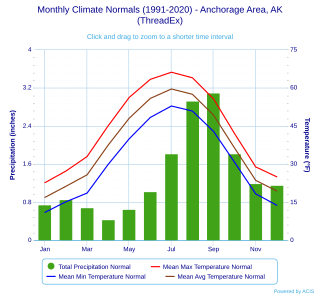
Anchorage, Alaska has a subarctic climate with the code Dfc according to the Köppen climate classification due to its short, cool summers. The weather on any given day is very unpredictable. Some winters feature several feet of snow and cold temperatures, while the summers are typically mild but are cool compared to the contiguous US and interior Alaska. Because of Anchorage's high latitude, summer days are very long and winter daylight hours are very short. The longest day of sunlight being 18hrs and 21 minutes, and shortest being 5 hours and 28 minutes. Anchorage is often cloudy during the winter, which decreases the amount of sunlight experienced by residents.

<span class="mw-page-title-main">Climate of South Carolina</span> Overview of the climate of the U.S. state of South Carolina

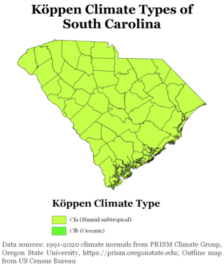
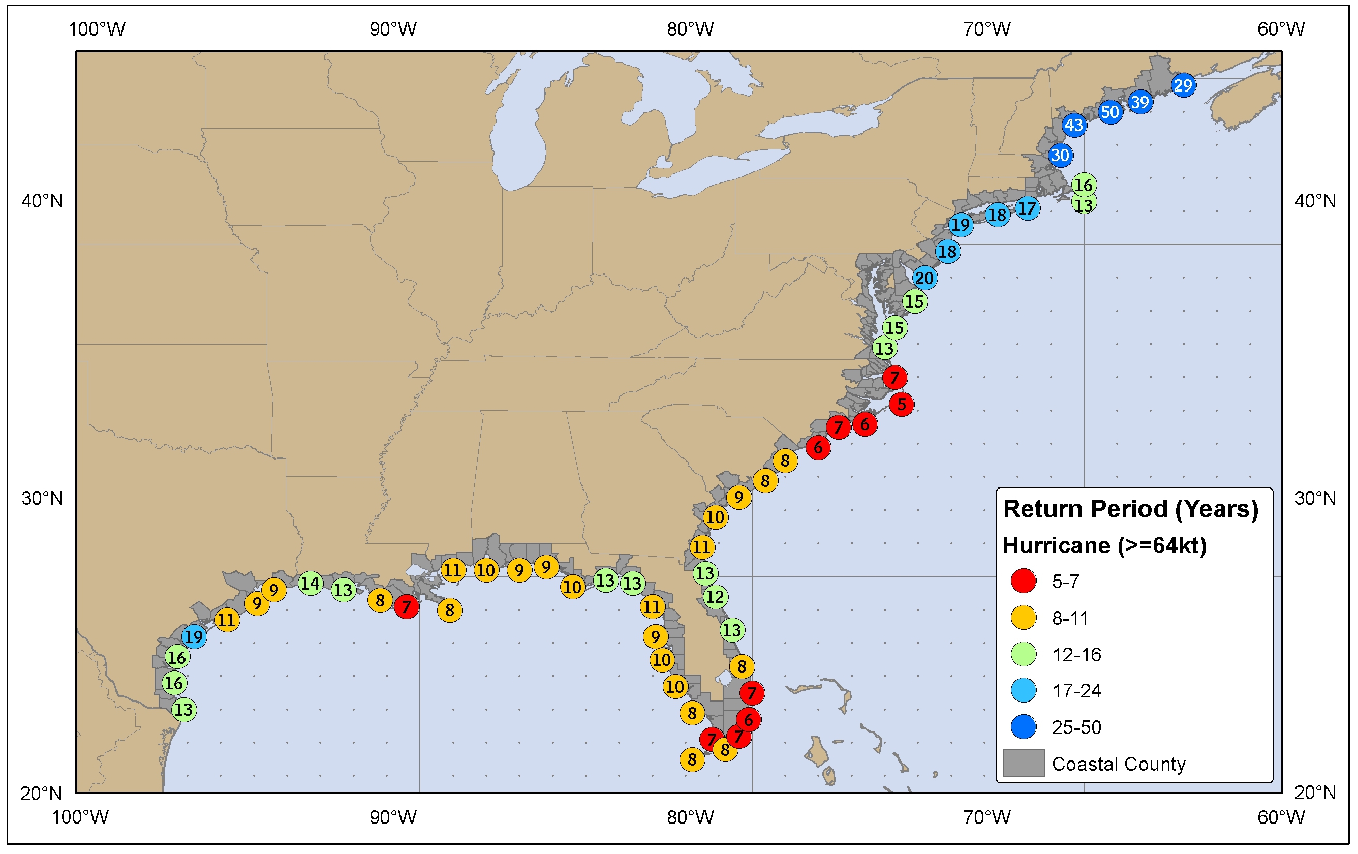
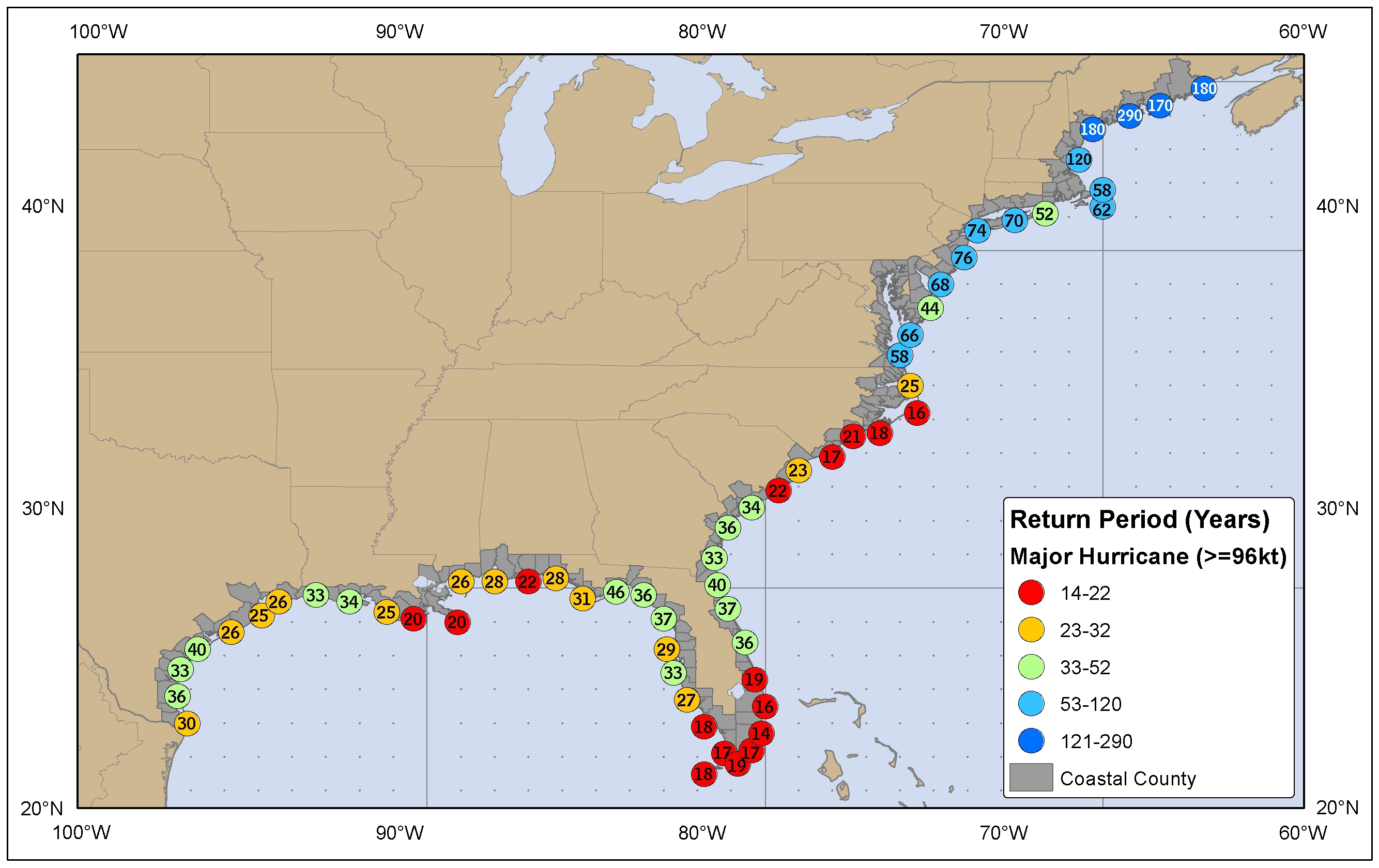
South Carolina has a humid subtropical climate, with hot summers throughout most of the state. But, an exception does occur in the Blue Ridge Mountains, as outlier pockets of an Oceanic Climate do exist. Mild winters predominate in the eastern and southern part of the state, but cool to occasionally cold winters are the standard in the northwestern area of the state, especially areas at or above 600 feet in elevation. On average, between 40 and 80 inches of precipitation falls annually across the state, potentially even in excess of 100 inches in portions of the Appalachian temperate rainforest. Tropical cyclones, and afternoon thunderstorms due to hot and humid conditions, contribute to precipitation during the summer and sometimes fall months, while extratropical cyclones contribute to precipitation during the fall, winter, and spring months. The coast experiences nearly all of their tropical weather impacts from storms coming directly from the Atlantic coast. The northwestern area of the state can receive impacts from both Atlantic basin storms moving westward from the coast and also occasionally very heavy rainfall and flooding from storms originating from the Gulf of Mexico that move inland towards the northeast after making landfall from the Florida Panhandle to Louisiana.

<span class="mw-page-title-main">Geography of Connecticut</span> Overview of the Geography of Connecticut

The U.S. state of Connecticut is bordered on the south by Long Island Sound, on the west by New York, on the north by Massachusetts, and on the east by Rhode Island. The state capital and fourth largest city is Hartford, and other major cities and towns include Bridgeport, New Haven, Stamford, Waterbury, Norwalk, Danbury, New Britain, Greenwich, and Bristol. There are 169 incorporated towns in Connecticut, with cities and villages included within some towns.

<span class="mw-page-title-main">Climate of New Jersey</span> Overview of the climate of the U.S. state of New Jersey

The climate of New Jersey classification of the U.S. state of New Jersey is humid subtropical in South Jersey with a humid continental climate in North Jersey, particularly in the northwestern area of the state. The northwest part of New Jersey is the snowiest due to the higher elevations that earn it a Dfb classification. During the winters, New Jersey can experience Nor'easters, which are snowstorms that affect the Northeastern United States, and Atlantic Canada. However, many would-be snow events in the state end up turning to rain due to warm ocean air being brought in by the storm. New Jersey's climate is shaped by its proximity to the Atlantic Ocean which provides moisture and moderates temperatures. According to climatology research by the U.S. National Oceanic and Atmospheric Administration, New Jersey has been the fastest-warming state by average air temperature over a 100-year period beginning in the early 20th century, related to global warming.

<span class="mw-page-title-main">Climate of Allentown, Pennsylvania</span> Overview of the climate of Allentown, Pennsylvania, United States

The climate of Allentown, Pennsylvania is classified as a humid continental climate. Allentown's warmest month is July with a daily average temperature of 74.7 °F (23.7 °C) and the coldest month being January with a daily average of 29.4 °F (−1.4 °C). The average precipitation of Allentown is 45.35 inches (1,152 mm) per year.

<span class="mw-page-title-main">Climate of New England</span> Overview of the climate of New England

The climate of New England varies greatly across its 500-mile (800 km) span from northern Maine to southern Connecticut.

<span class="mw-page-title-main">Climate of Little Rock, Arkansas</span>

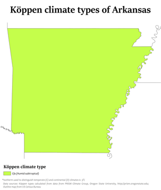
Little Rock has a humid subtropical climate, with hot, usually humid summers, but subject to drought, primarily in late summer. According to the Trewartha climate classification system, Little Rock is subtropical because nine of its months exceed 50 °F (10 °C) in average temperature. Summers are usually hot, occasionally extremely hot; winters are short and cool, but with marked temperature variations, as the area is subject to alternating incursions of warm, moist air from the Gulf of Mexico and cold, dry air from Canada.

<span class="mw-page-title-main">2014–15 North American winter</span> Winter season in North America

The 2014–15 North American winter was frigid and prolifically wintry, especially across the eastern half of North America in the months of January–March. The season began early, with many places in North America experiencing their first wintry weather during mid-November. A period of below-average temperatures affected much of the contiguous United States, and several records were broken. An early trace of snowfall was recorded in Arkansas. There were greater accumulations of snow across parts of Oklahoma as well. A quasi-permanent phenomenon referred to as the polar vortex may have been partly responsible for the cold weather. Temperatures in much of the United States dropped 15 to 35 °F below average by November 19, following a southward "dip" of the polar vortex into the eastern two-thirds of the country. The effects of this dip were widespread, bringing about temperatures as low as 28 °F (−2 °C) in Pensacola, Florida. Following a significant snowstorm there, Buffalo, New York received several feet of snow from November 17–21. In addition, significant winter weather occurred throughout the season, including a major blizzard that struck the Northeastern United States at the end of January, another blizzard that affected much of the Northern United States days later in early February, and several significant snow events paired with very frigid temperatures for much of February.

References

  1. "Mayor Adams, Trust For Governors Island Unveil Finalist Proposals For Climate Solutions Center". City of New York. October 26, 2022. Retrieved October 29, 2022.
  2. Northeast Regional Climate Center (2012). "Normal Average Temperatures (Deg F): Annual (1971-2000)". Cornell University. Archived from the original on 2013-11-02. Retrieved 2012-03-14.
  3. 1 2 3 4 5 6 "Climate of New York". New York State Climate Office - Cornell University. Archived from the original on April 12, 2008. Retrieved April 10, 2008.
  4. Gerald D. Bell; Lance F. Bosart (January 1988). "Appalachian Cold Air Damming". Monthly Weather Review. American Meteorological Society. 116 (1): 137. Bibcode:1988MWRv..116..137B. doi: 10.1175/1520-0493(1988)116<0137:ACAD>2.0.CO;2 .
  5. National Aeronautics and Space Administration (2012-03-07). "Reducing the Urban Heat Island Effect: Bright Is the New Black as New York Roofs Go Cool". ScienceDaily. Retrieved 2012-03-14.
  6. "Heat stroke tops list of weather-related deaths". pennlive. 2019-07-19. Retrieved 2019-12-17.
  7. Orr, Steve (February 26, 2015). "Rochester's coldest month. Ever". Democrat & Chronicle. Retrieved December 24, 2015.
  8. Lahman, Sean (December 24, 2015). "Record warmth, but snow is coming". Democrat & Chronicle. Retrieved December 24, 2015.
  9. 1 2 3 4 5 "State Climate Extremes Committee (SCEC)". National Oceanic and Atmospheric Administration. Retrieved 7 January 2018.
  10. National Climatic Data Center (2005-06-24). "Mean Sky Cover (Percent)" (PDF). National Oceanic and Atmospheric Administration. Archived from the original (PDF) on 2013-02-17. Retrieved 2012-03-14.
  11. Allan D. Randall (1996). Mean Annual Runoff, Precipitation, and Evapotranspiration in the Glaciated Northeast United States, 1951–1980. United States Geological Survey. Retrieved on 2008-03-01.
  12. Christopher Daily; Jenny Weisburg (2008-12-19). "Annual Average Precipitation: New York". Western Region Climate Center. Retrieved 2012-03-14.
  13. Michael G. Landin; Lance F. Bosart (June 1985). "Diurnal Variability of Precipitation in the Northeastern United States". Monthly Weather Review. American Meteorological Society. 113 (6): 989–1014. Bibcode:1985MWRv..113..989L. doi: 10.1175/1520-0493(1985)113<0989:DVOPIT>2.0.CO;2 .
  14. George J. Maglaras; Jeff S. Waldstreicher; Paul J. Kocin; Anthony F. Gigi; Robert A. Marine (March 1995). "Winter Weather Forecasting throughout the Eastern United States. Part 1: An Overview". Weather and Forecasting. American Meteorological Society. 10 (1): 6. Bibcode:1995WtFor..10....5M. doi: 10.1175/1520-0434(1995)010<0005:wwftte>2.0.co;2 .
  15. Frank P. Colby, Jr. (2003). Mesoscale Snow Bands in an Ocean-Effect Snowstorm. Archived 2012-02-20 at the Wayback Machine University of Massachusetts Lowell. Retrieved on 2008-03-01.
  16. Neil F. Laird (2004). Understanding Lake-Effect Snow Storms in the Finger Lakes & Great Lakes Regions. Finger Lakes Institute. Retrieved on 2008-03-01.
  17. National Weather Service Forecast Office, Buffalo, New York (2003-09-23). "Average Seasonal Snowfall Over the Eastern Great Lakes Region". National Weather Service Eastern Region Headquarters. Archived from the original on 2013-12-10. Retrieved 2012-03-14.{{cite web}}: CS1 maint: multiple names: authors list (link)
  18. David R. Vallee (Summer 2002). A Centennial Review of Major Land-Falling Tropical Cyclones in Southern New England. Government of Massachusetts. Retrieved on 2008-03-01.
  19. Barry Keim (June 1999). Current Climate of the New England Region: New England Regional Assessment. Archived 2012-02-20 at the Wayback Machine University of New Hampshire. Retrieved on 2008-03-19.
  20. "Snowfall Extremes | Snow and Ice | National Centers for Environmental Information (NCEI)".
  21. "A Breath of Fresh New York Air". The New York Post. 2007-06-03. Archived from the original on 2007-06-06. Retrieved 2007-06-06.
  22. "Archived copy" (PDF). Archived from the original (PDF) on 2013-05-24. Retrieved 2016-01-16.{{cite web}}: CS1 maint: archived copy as title (link)
  23. "2002 Assessment Results | 2002 National-Scale Air Toxics Assessment | Technology Transfer Network Air Toxics Web site | US EPA". Archived from the original on 2012-01-11. Retrieved 2011-08-27.
  24. National Climatic Data Center (2012-03-07). "U.S. Tornado Climatology". National Oceanic and Atmospheric Administration . Retrieved 2012-03-14.
  25. National Climatic Data Center (2012-03-07). "Average Annual Number of EF3-EF5 Tornadoes". National Oceanic and Atmospheric Administration . Retrieved 2012-03-14.
  26. National Hurricane Center (2012-03-01). "Return Period (Years) Hurricane". National Oceanic and Atmospheric Administration . Retrieved 2012-03-14.
  27. National Hurricane Center (2012-03-01). "Return Period (Years) Major Hurricane". National Oceanic and Atmospheric Administration . Retrieved 2012-03-14.
  28. "Summary of Monthly Normals 1991–2020". National Oceanic and Atmospheric Administration. Archived from the original on May 4, 2021. Retrieved May 4, 2021.
  29. "NowData – NOAA Online Weather Data". National Oceanic and Atmospheric Administration . Retrieved May 4, 2021.
  30. "WMO Climate Normals for ALBANY/ALBANY COUNTY, NY 1961–1990". National Oceanic and Atmospheric Administration. Retrieved September 16, 2020.
  31. "Albany, NY - Detailed climate information and monthly weather forecast". Weather Atlas. Yu Media Group. Retrieved June 29, 2019.
  32. "NowData – NOAA Online Weather Data". National Oceanic and Atmospheric Administration . Retrieved May 4, 2021.
  33. "Summary of Monthly Normals 1991–2020". National Oceanic and Atmospheric Administration. Archived from the original on May 4, 2021. Retrieved May 4, 2021.
  34. "WMO Climate Normals for Buffalo/Greater Buffalo, NY 1961–1990". National Oceanic and Atmospheric Administration. Retrieved September 18, 2020.
  35. "Buffalo, New York, USA - Monthly weather forecast and Climate data". Weather Atlas. Retrieved July 3, 2019.
  36. "NowData – NOAA Online Weather Data". National Oceanic and Atmospheric Administration. Retrieved August 9, 2021.
  37. "Station: Islip LI MacArthur AP, NY". U.S. Climate Normals 2020: U.S. Monthly Climate Normals (1991–2020). National Oceanic and Atmospheric Administration. Retrieved August 9, 2021.
  38. Belvedere Castle at NYC Parks
  39. "NowData – NOAA Online Weather Data". National Oceanic and Atmospheric Administration . Retrieved May 4, 2021.
  40. "Summary of Monthly Normals 1991–2020". National Oceanic and Atmospheric Administration. Archived from the original on May 4, 2021. Retrieved May 4, 2021.
  41. "New York Central Park, NY Climate Normals 1961−1990". National Oceanic and Atmospheric Administration . Retrieved July 18, 2020.
  42. 1 2 "New York, New York, USA - Monthly weather forecast and Climate data". Weather Atlas. Retrieved July 4, 2019.
  43. "NowData – NOAA Online Weather Data". National Oceanic and Atmospheric Administration. Retrieved May 9, 2021.
  44. "Station: New York JFK INTL AP, NY". U.S. Climate Normals 2020: U.S. Monthly Climate Normals (1991–2020). National Oceanic and Atmospheric Administration. Retrieved May 9, 2021.
  45. "New York/JFK, NY Climate Normals 1961−1990". NOAA. Retrieved March 23, 2014.
  46. "NowData – NOAA Online Weather Data". National Oceanic and Atmospheric Administration . Retrieved May 4, 2021.
  47. "Summary of Monthly Normals 1991–2020". National Oceanic and Atmospheric Administration. Archived from the original on May 5, 2021. Retrieved May 4, 2021.
  48. "WMO Climate Normals for ROCHESTER/ROCHESTER-MONROE CO,NY 1961–1990". National Oceanic and Atmospheric Administration. Retrieved July 28, 2020.

Notes

  1. An unofficial, but widely accepted record 24-hr snowfall of 54 inches was observed at Tug Hill Plateau in January 1976. [9]
  2. Mean monthly maxima and minima (i.e. the expected highest and lowest temperature readings at any point during the year or given month) calculated based on data at said location from 1991 to 2020.
  3. Official records for Albany kept January 1874 to May 1938 at downtown and at Albany Int'l since June 1938. For more information, see Threadex
  4. Mean monthly maxima and minima (i.e. the expected highest and lowest temperature readings at any point during the year or given month) calculated based on data at said location from 1991 to 2020.
  5. Official records for Buffalo kept January 1871 to June 1943 at downtown and at Buffalo Niagara Int'l since July 1943. For more information, see Threadex
  6. Mean monthly maxima and minima (i.e. the expected highest and lowest temperature readings at any point during the year or given month) calculated based on data at said location from 1991 to 2020.
  7. Mean monthly maxima and minima (i.e. the expected highest and lowest temperature readings at any point during the year or given month) calculated based on data at said location from 1991 to 2020
  8. Official weather observations for Central Park were conducted at the Arsenal at Fifth Avenue and 64th Street from 1869 to 1919, and at Belvedere Castle since 1919. [38]
  9. Mean monthly maxima and minima (i.e. the expected highest and lowest temperature readings at any point during the year or given month) calculated based on data at said location from 1991 to 2020.
  10. Mean monthly maxima and minima (i.e. the expected highest and lowest temperature readings at any point during the year or given month) calculated based on data at said location from 1991 to 2020.
  11. Official records for Rochester kept January 1871 to September 1940 at downtown and at Greater Rochester Int'l since October 1940. For more information, see Threadex