College Township, Centre County, Pennsylvania

Last updated

College Township,
Centre County,
Pennsylvania
Township
Mount Nittany2.JPG
Mount Nittany and College Township seen from the Bryce Jordan Center at Penn State
Motto: 
"Gateway to the Centre Region" [1]
Map of College Township, Centre County, Pennsylvania Highlighted.png
Location of College Township in Centre County, Pennsylvania
Map of Pennsylvania highlighting Centre County.svg
Location of Centre County in Pennsylvania
Country United States
State Pennsylvania
County Centre
Settled1800
Incorporated1857
Government
  TypeTownship Council
  Council ChairL. Eric Bernier
  Vice-ChairD. Richard (Rich) Francke
  Council MemberCarla Stilson
  Council MemberAnthony Fragola
  Council MemberPaul Takac
Area
[2]
  Total18.55 sq mi (48.05 km2)
  Land18.55 sq mi (48.05 km2)
  Water0.00 sq mi (0.00 km2)
Population
 (2020) [3]
  Total10,762
  Estimate 
(2021) [4]
10,695
  Density554.63/sq mi (214.15/km2)
Time zone UTC-5 (EST)
  Summer (DST) UTC-4 (EDT)
FIPS code 42-027-15136
Website www.collegetownship.org

College Township is a township in Centre County, Pennsylvania. It is part of the State College, Pennsylvania metropolitan statistical area. The population was 10,762 at the 2020 census, which was a 13% increase from the 2010 census. [5] College Township was formed on November 25, 1875, from Howard Township.

Contents

College Township is served by the State College Area School District for K-12 education. Pennsylvania State University is partially in College Township. [6] [7]

History

Two major Native American archaeological sites are located in College Township. Known as the Tudek and Houserville sites, they were used during the Archaic period for the quarrying and reduction of stone tools made of jasper. Both sites are listed on the National Register of Historic Places. [8] [9]

Geography

According to the U.S. Census Bureau, the township has a total area of 18.6 square miles (48.1 km2), all land. [10] Mount Nittany is a prominent and well-known feature in the township.

College Township is bordered by Ferguson Township to the west, Patton Township to the northwest, Benner Township to the north, Harris Township to the south, and east, and the borough of State College to the south and west.

Demographics

Historical population
CensusPop.Note
2000 8,489
2010 9,52112.2%
2020 10,76213.0%
2021 (est.)10,695 [4] −0.6%
[3]

As of a 2015 census estimate, the township was 89.9% Non-Hispanic White, 4.3% Black or African American, 1.2% Native American Alaska Native, 4.8% Asian, 0.3% Some other race, and 2.1% were Two or More Races. Hispanics and Latinos (of any race) were 1.1% of the population. [ dead link ]

Government

College Township is part of Pennsylvania's 12th congressional district, represented by Republican Fred Keller, elected in 2019.

Public Safety

College Township contracts police service from the State College Police Department, while Penn State University Police provides coverage to University Park campus. [11] [12]

It is served by the Alpha Fire Company for fire protection, which maintains one of its two substations in the College Township Municipal Building. Centre Lifelink EMS is based in College Township, as is Mount Nittany Medical Center which also provides emergency medical services. [13] [14]

Related Research Articles

<span class="mw-page-title-main">Centre County, Pennsylvania</span> County in Pennsylvania, United States

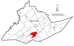
Centre County is a county in the Commonwealth of Pennsylvania, United States. As of the 2020 census, the population was 158,172. Its county seat is Bellefonte. Centre County comprises the State College, PA Metropolitan Statistical Area. The county is part of the Central Pennsylvania region of the state.

<span class="mw-page-title-main">Bellefonte, Pennsylvania</span> Borough in Pennsylvania, United States

Bellefonte is a borough in, and the county seat of, Centre County, Pennsylvania, United States. It is approximately twelve miles northeast of State College and is part of the State College, Pennsylvania metropolitan statistical area. The borough population was 6,187 at the 2010 census. It houses the Centre County Courthouse, located downtown on the diamond. Bellefonte has also been home to five of Pennsylvania's governors, as well as two other governors. All seven are commemorated in a monument located at Talleyrand Park.

<span class="mw-page-title-main">Benner Township, Centre County, Pennsylvania</span> Township in Pennsylvania, United States

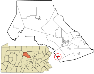
Benner Township is a township in Centre County, Pennsylvania, United States. It is part of the State College, Pennsylvania Metropolitan Statistical Area. It is located approximately at 40°54′48″N77°45′53″W along Buffalo Run Road, near Bellefonte.

<span class="mw-page-title-main">Boalsburg, Pennsylvania</span> Census-designated place in Pennsylvania, United States

Boalsburg is an unincorporated community and census-designated place (CDP) in Harris Township, Centre County, Pennsylvania, United States. It is part of the State College, Pennsylvania Metropolitan Statistical Area. The population was 3,722 at the 2010 census. The village claims to be the birthplace of Memorial Day. However, that claim was brought into question by Bellware and Gardiner in their book, The Genesis of the Memorial Day Holiday in America, in 2014. In their book, Bellware and Gardiner point out that the Boalsburg story was first published in 1904, forty years after the fact with no indication that General Logan drew inspiration from any activities in Boalsburg and no evidence that it started the holiday.

<span class="mw-page-title-main">Harris Township, Centre County, Pennsylvania</span> Township in Pennsylvania, United States

Harris Township is a township in Centre County, Pennsylvania, United States. It is part of the State College, Pennsylvania Metropolitan Statistical Area. Boalsburg, a census-designated place (CDP), is located within the township. The population was 4,873 at the 2010 census, which is a 4.6% increase since the 2000 census.

<span class="mw-page-title-main">Houserville, Pennsylvania</span> Census-designated place in Pennsylvania, United States

Houserville is an unincorporated community and census-designated place (CDP) in Centre County, Pennsylvania, United States. It is part of the State College, Pennsylvania Metropolitan Statistical Area. The population was 1,814 at the 2010 census.

<span class="mw-page-title-main">Lemont, Pennsylvania</span> Census-designated place in Pennsylvania, United States

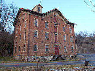
Lemont is an unincorporated community and census-designated place (CDP) in Centre County, Pennsylvania, United States, and is the location of the only remaining granary in Pennsylvania. It is part of the State College, Pennsylvania Metropolitan Statistical Area. The population was 2,270 at the 2010 census.

<span class="mw-page-title-main">Madisonburg, Pennsylvania</span> Census designated place in Pennsylvania, United States

Madisonburg is an unincorporated community and census-designated place (CDP) in Miles Township, Centre County, Pennsylvania, United States. It is part of the State College, Pennsylvania Metropolitan Statistical Area. The population was 168 at the 2010 census.

<span class="mw-page-title-main">Miles Township, Pennsylvania</span> Township in Pennsylvania, United States

Miles Township is a township in Centre County, Pennsylvania, United States. It is part of the State College, Pennsylvania Metropolitan Statistical Area. The population was 2,013 at the 2020 census, an increase over the figure of 1,983 tabulated in 2010. Miles Township and nearby Milesburg were named after Samuel Miles, who co-owned the Centre Furnace, along with Colonel John Patton.

<span class="mw-page-title-main">Pine Grove Mills, Pennsylvania</span> Census-designated place in Pennsylvania, United States

Pine Grove Mills is an unincorporated community, village, and census-designated place (CDP) in Ferguson Township, Centre County, Pennsylvania, United States. It is part of the State College, Pennsylvania Metropolitan Statistical Area. The population was 1,481 at the 2020 census.

<span class="mw-page-title-main">Pleasant Gap, Pennsylvania</span> Census-designated place in Pennsylvania, United States

Pleasant Gap is an unincorporated community and census-designated place (CDP) in Centre County, Pennsylvania, United States. It is part of the State College, Pennsylvania Metropolitan Statistical Area. The population was 2,879 at the 2010 census.

<span class="mw-page-title-main">Rebersburg, Pennsylvania</span> Census-designated place in Pennsylvania, United States

Rebersburg is an unincorporated community and census-designated place (CDP) in Centre County, Pennsylvania, United States. Rebersburg is part of the State College, Pennsylvania Metropolitan Statistical Area. The population was 494 at the 2010 census and includes many Amish in the area.

<span class="mw-page-title-main">Spring Township, Centre County, Pennsylvania</span> Township in Pennsylvania, United States

Spring Township is a township in Centre County, Pennsylvania, United States. It is part of the State College, Pennsylvania Metropolitan Statistical Area. The population was 8,051 at the 2020 census, which was a 7.8% increase from the 2010 census.

<span class="mw-page-title-main">State College, Pennsylvania</span> Home rule municipality in Pennsylvania, United States

State College is a home rule municipality in Centre County, Pennsylvania, United States. It is a college town, dominated economically, culturally, and demographically by the presence of the University Park campus of The Pennsylvania State University.

<span class="mw-page-title-main">Worth Township, Centre County, Pennsylvania</span> Township in Pennsylvania, United States

Worth Township is a township in Centre County, Pennsylvania, United States. It is part of the State College, Pennsylvania Metropolitan Statistical Area. The population was 734 at the 2020 census.

<span class="mw-page-title-main">Penns Valley</span> Region in Pennsylvania, United States

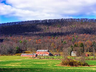
Penns Valley is an eroded anticlinal valley of the Pennsylvania ridge and valley geologic region of the Appalachian Mountain range. The valley is located in southern Centre County, Pennsylvania. Along with the Nittany Valley to the north and east, it is part of the larger Nittany Anticlinorium. It is bordered by Mount Nittany to the north, the Seven Mountains range to the south, and connects to the larger Nittany Valley to the west. There are two smaller subordinate valleys typically associated with the greater valley: Georges Valley in the south, separated by Egg Hill, and Brush Valley in the north, separated by Brush Mountain.

<span class="mw-page-title-main">Bald Eagle Creek (West Branch Susquehanna River tributary)</span>

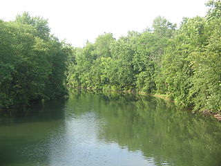
Bald Eagle Creek is a 55.2-mile-long (88.8 km) tributary of the West Branch Susquehanna River mostly in Centre County, Pennsylvania, in the United States.

<span class="mw-page-title-main">Houserville Site</span> United States historic place

The Houserville Site is an archaeological site located near State College in Centre County, Pennsylvania, United States. Used as a stone workshop by prehistoric Native Americans ten thousand years ago, it has been recognized as a prime candidate for prehistoric preservation.

<span class="mw-page-title-main">Tudek Site</span> Native American archaeological site (stone quarry) in Pennsylvania

The Tudek Site is an archaeological site located near State College in Centre County, Pennsylvania, United States. Used as a stone quarry by prehistoric Native Americans ten thousand years ago, it has been recognized as a prime candidate for prehistoric preservation.

<span class="mw-page-title-main">Lamar, Pennsylvania</span> Census-designated place in Pennsylvania, United States

Lamar is a census-designated place in Porter Township in southern Clinton County, Pennsylvania, United States. As of the 2010 census the population was 562.

References

  1. "College Township, Centre County, Pennsylvania". College Township, Centre County, Pennsylvania. Archived from the original on July 31, 2012. Retrieved August 10, 2012.
  2. "2016 U.S. Gazetteer Files". United States Census Bureau. Retrieved August 13, 2017.
  3. 1 2 "2020 Census Data". United StatesCensus Bureau. Retrieved July 22, 2023.
  4. 1 2 Bureau, US Census. "City and Town Population Totals: 2020—2021". Census.gov. US Census Bureau. Retrieved August 11, 2022.
  5. Census 2010: Pennsylvania. Usatoday.Com. Retrieved on July 23, 2013.
  6. "State College borough, Pennsylvania [ permanent dead link ]." U.S. Census Bureau. Retrieved on August 24, 2009.
  7. "College township, Pennsylvania [ permanent dead link ]." U.S. Census Bureau. Retrieved on August 24, 2009.
  8. Stevenson, Christopher M., and Conran Hay. National Register of Historic Places Inventory/Nomination: Houserville Site (36CE65). National Park Service, October 15, 1980.
  9. Stevenson, Christopher M., and Conran Hay. National Register of Historic Places Inventory/Nomination: Tudek Site. National Park Service, October 10, 1980.
  10. "Geographic Identifiers: 2010 Census Summary File 1 (G001): College township, Centre County, Pennsylvania". U.S. Census Bureau, American Factfinder. Archived from the original on April 9, 2015. Retrieved April 9, 2015.
  11. "FAQs". College Township, PA. Retrieved August 5, 2023.
  12. "Police". Penn State. Retrieved November 4, 2023.
  13. "Contact". Centre Life Link EMS. Retrieved August 5, 2023.
  14. "Mount Nittany Medical Center's emergency medical services team providing excellent pre-hospital care". Mount Nittany Health. August 18, 2020. Retrieved November 4, 2023.

40°49′00″N77°52′34″W / 40.81667°N 77.87611°W / 40.81667; -77.87611