Sandy Ridge, Pennsylvania

Last updated

Sandy Ridge, Pennsylvania
Map of Sandy Ridge, Centre County, Pennsylvania Highlighted.png
Location within Centre County
USA Pennsylvania location map.svg
Red pog.svg
Sandy
Ridge
Location within the U.S. state of Pennsylvania
Coordinates: 40°48′43″N78°13′56″W / 40.81194°N 78.23222°W / 40.81194; -78.23222
Country United States
State Pennsylvania
County Centre
Township Rush
Area
  Total0.64 sq mi (1.65 km2)
  Land0.64 sq mi (1.65 km2)
  Water0.0 sq mi (0.0 km2)
Elevation
1,850 ft (560 m)
Population
 (2010)
  Total407
  Density639/sq mi (246.7/km2)
Time zone UTC-5 (Eastern (EST))
  Summer (DST) UTC-4 (EDT)
ZIP codes
16677
Area code 814
FIPS code 42-67872
GNIS feature ID1186955 [1]

Sandy Ridge is an unincorporated community and census-designated place (CDP) in Centre County, Pennsylvania, United States. It is part of the State College, Pennsylvania Metropolitan Statistical Area. The population was 407 at the 2010 census. [2]

Contents

Geography

Sandy Ridge is located in Pennsylvania, at 40°48′43″N78°13′56″W / 40.81194°N 78.23222°W / 40.81194; -78.23222 (40.811904, -78.232142), [3] southwest of the center of Rush Township. It sits at an elevation of 1,800 to 1,950 feet (550 to 590 m), 3 miles (5 km) northwest of the physical Sandy Ridge, the 2,500-foot-high (760 m) local expression of the Allegheny Front.

Pennsylvania Route 970 passes through the community, leading northwest 4 miles (6 km) to Osceola Mills on Moshannon Creek in Clearfield County. Pennsylvania Route 350 forms the eastern edge of the community, leading north 6 miles (10 km) to Philipsburg (also on Moshannon Creek) and south over the Allegheny Front 9 miles (14 km) to Interstate 99 at Bald Eagle.

According to the United States Census Bureau, the Sandy Ridge CDP has a total area of 0.64 square miles (1.65 km2), all of it land. [2]

Demographics

As of the census [4] of 2010, there were 407 people, 170 households, and 129 families residing in the CDP. The population density was 620.1 inhabitants per square mile (239.4/km2). There were 194 housing units at an average density of 295.6/sq mi (114.2/km2). The racial makeup of the CDP was 99.8% White and 0.2% other.

There were 170 households, out of which 28.8% had children under the age of 18 living with them, 61.2% were married couples living together, 5.9% had a male householder with no wife present, 8.8% had a female householder with no husband present, and 24.1% were non-families. 22.9% of all households were made up of individuals, and 14.1% had someone living alone who was 65 years of age or older. The average household size was 2.39 and the average family size was 2.73.

In the CDP, the population was spread out, with 19.7% under the age of 18, 7.4% from 18 to 24, 23.6% from 25 to 44, 28.2% from 45 to 64, and 21.1% who were 65 years of age or older. The median age was 45 years. For every 100 females, there were 95.7 males. For every 100 females age 18 and over, there were 92.4 males.

The median income for a household in the CDP was $41,406, and the median income for a family was $79,500. The per capita income for the CDP was $24,197. None of the families and 2.5% of the population were living below the poverty line, including no under eighteens and none of those over 64.

Related Research Articles

<span class="mw-page-title-main">Haysville, Pennsylvania</span> Borough in Pennsylvania, United States

Haysville is a borough in Allegheny County, Pennsylvania, United States, along the Ohio River. The population was 81 according to the 2020 census, making it the least-populous municipality in Allegheny County.

<span class="mw-page-title-main">Penn Hills, Pennsylvania</span> Home rule township in Pennsylvania, United States

Penn Hills is a township with home rule status in Allegheny County, Pennsylvania, United States. The population was 41,059 as of the 2020 census. A suburb of Pittsburgh, Penn Hills is the second-largest municipality in Allegheny County.

<span class="mw-page-title-main">Russellton, Pennsylvania</span> Census-designated place in Pennsylvania, United States

Russellton is a census-designated place (CDP) in Allegheny County, Pennsylvania, United States. The population was 1,330 at the 2020 census.

Spring Ridge is a census-designated place (CDP) in Spring Township, Berks County, Pennsylvania, United States. The population was 1,003 at the 2010 census.

West Wyomissing is a census-designated place (CDP) in Spring Township, Berks County, Pennsylvania, United States. The population was 3,407 at the 2010 census.

<span class="mw-page-title-main">Juniata Township, Blair County, Pennsylvania</span> Township in Pennsylvania, United States

Juniata Township is a township in Blair County, Pennsylvania, United States. It is part of the Altoona, PA Metropolitan Statistical Area. The population was 968 at the 2020 census.

<span class="mw-page-title-main">Meadowood, Pennsylvania</span> Census-designated place in Pennsylvania, United States

Meadowood is a census-designated place (CDP) in Butler County, Pennsylvania, United States. The population was 2,693 at the 2010 census.

<span class="mw-page-title-main">Beaverdale, Pennsylvania</span> Census-designated place in Pennsylvania, United States

Beaverdale is an unincorporated community and census-designated place (CDP) in Cambria County, Pennsylvania, United States. The population was 1,035 at the 2010 census. Prior to that time, the CDP was known as Beaverdale-Lloydell.

<span class="mw-page-title-main">Vinco, Pennsylvania</span> Census-designated place in Pennsylvania, United States

Vinco is an unincorporated community and census-designated place (CDP) in Jackson Township, Cambria County, in the U.S. state of Pennsylvania. The population was 1,305 at the 2010 census.

<span class="mw-page-title-main">Madisonburg, Pennsylvania</span> Census designated place in Pennsylvania, United States

Madisonburg is an unincorporated community and census-designated place (CDP) in Miles Township, Centre County, Pennsylvania, United States. It is part of the State College, Pennsylvania Metropolitan Statistical Area. The population was 168 at the 2010 census.

<span class="mw-page-title-main">North Philipsburg, Pennsylvania</span> Census designated place in Pennsylvania, United States

North Philipsburg is an unincorporated community and census-designated place (CDP) in Centre County, Pennsylvania, United States. It is part of the State College, Pennsylvania Metropolitan Statistical Area. The population was 660 at the 2010 census.

<span class="mw-page-title-main">Pine Glen, Pennsylvania</span> Census-designated place in Pennsylvania, United States

Pine Glen is an unincorporated community and census-designated place (CDP) in Centre County, Pennsylvania, United States. It is part of the State College, Pennsylvania Metropolitan Statistical Area. It is part of Burnside Township. The population was 190 at the 2010 census.

<span class="mw-page-title-main">South Philipsburg, Pennsylvania</span> Place in Pennsylvania, United States

South Philipsburg is a census-designated place (CDP), formerly a borough, located in Centre County, Pennsylvania, United States. It is part of the State College, Pennsylvania Metropolitan Statistical Area. The population was 410 at the 2010 census. As of January 1, 2007, the borough government was dissolved and the area reverted to Rush Township.

<span class="mw-page-title-main">Bigler Township, Clearfield County, Pennsylvania</span> Township in Pennsylvania, United States

Bigler Township is a township in Clearfield County, Pennsylvania, United States. The population was 1,242 at the 2020 census.

<span class="mw-page-title-main">Gulich Township, Clearfield County, Pennsylvania</span> Township in Pennsylvania, United States

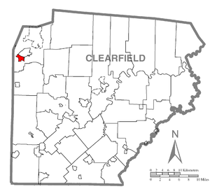
Gulich Township is a township in Clearfield County, Pennsylvania, United States. The population was 1,204 at the 2020 census.

<span class="mw-page-title-main">Sandy, Pennsylvania</span> Census-designated place in Pennsylvania, United States

Sandy is a census-designated place (CDP) in Clearfield County, Pennsylvania, United States. The population was 1,362 at the 2020 census.

<span class="mw-page-title-main">Treasure Lake, Pennsylvania</span> Census-designated place in Pennsylvania, United States

Treasure Lake is a census-designated place (CDP) in Clearfield County, Pennsylvania, United States. The population was 5,460 at the 2020 census. Treasure Lake is a semi-private, gated community centered around its namesake.

<span class="mw-page-title-main">Woodward Township, Clearfield County, Pennsylvania</span> Township in Pennsylvania, United States

Woodward Township is a township in Clearfield County, Pennsylvania, United States. The population was 4,108 at the 2020 census.

<span class="mw-page-title-main">Lucerne Mines, Pennsylvania</span> Census-designated place in Pennsylvania, United States

Lucernemines, usually written as Lucerne Mines, is a census-designated place (CDP) in Indiana County, Pennsylvania, United States. The population was 937 at the 2010 census.

<span class="mw-page-title-main">Washington Township, Jefferson County, Pennsylvania</span> Township in Pennsylvania, United States

Washington Township is a township in Jefferson County, Pennsylvania, United States. The population was 1,890 at the 2020 census. It was named for President George Washington.

References

  1. U.S. Geological Survey Geographic Names Information System: Sandy Ridge, Pennsylvania
  2. 1 2 "Geographic Identifiers: 2010 Census Summary File 1 (G001): Sandy Ridge CDP, Pennsylvania". U.S. Census Bureau, American Factfinder. Archived from the original on April 22, 2015. Retrieved April 21, 2015.
  3. "US Gazetteer files: 2010, 2000, and 1990". United States Census Bureau. February 12, 2011. Retrieved April 23, 2011.
  4. "U.S. Census website". United States Census Bureau . Retrieved January 31, 2008.