Lemont, Pennsylvania

Last updated

Lemont, Pennsylvania
Thompson Grain Elevator and Coal Sheds.jpg
Thompson Grain Elevator and coal sheds in Lemont
Map of Lemont, Centre County, Pennsylvania Highlighted.png
Location of Lemont in Centre County, Pennsylvania
USA Pennsylvania location map.svg
Red pog.svg
Lemont
Location within the U.S. state of Pennsylvania
Coordinates: 40°48′36″N77°49′5″W / 40.81000°N 77.81806°W / 40.81000; -77.81806
Country United States
State Pennsylvania
County Centre
Township College
Area
[1]
  Total1.25 sq mi (3.23 km2)
  Land1.25 sq mi (3.23 km2)
  Water0.00 sq mi (0.00 km2)
Elevation
1,046 ft (319 m)
Population
 (2020) [2]
  Total2,276
  Density1,828.11/sq mi (705.58/km2)
Time zone UTC-5 (Eastern (EST))
  Summer (DST) UTC-4 (EDT)
ZIP Code
16851
Area code 814
FIPS code 42-42632
GNIS feature ID1198221

Lemont is an unincorporated community and census-designated place (CDP) in Centre County, Pennsylvania, United States, and is the location of the only remaining granary in Pennsylvania. It is part of the State College, Pennsylvania Metropolitan Statistical Area. The population was 2,270 at the 2010 census. [3]

Contents

Geography

Lemont is located in southern Centre County at 40°48′36″N77°49′5″W / 40.81000°N 77.81806°W / 40.81000; -77.81806 (40.809911, -77.818152), [4] in the center of College Township. It is located 2 miles (3 km) northeast of the borough of State College. U.S. Route 322, the borough bypass, forms the western edge of Lemont. It is bordered by Houserville to the north.

The community is in the valley of Spring Creek, a northward-flowing tributary of Bald Eagle Creek and part of the Susquehanna River watershed. The southwestern end of Mount Nittany rises above the eastern edge of the village.

According to the U.S. Census Bureau, Lemont has a total area of 1.27 square miles (3.28 km2), all land. [3]

Demographics

Historical population
CensusPop.Note
2020 2,276
U.S. Decennial Census [5]

As of the census [6] of 2010, there were 2,270 people, 924 households, and 594 families residing in the CDP. The population density was 1,837.3 people per square mile (709.4 people/km2). There were 972 housing units at an average density of 786.7 per square mile (303.7/km2). The racial makeup of the CDP was 94.2% White, 1.8% Black or African American, 0.2% Native American, 1.9% Asian, 0.4% from other races, and 1.5% from two or more races. Hispanic or Latino of any race were 1.3% of the population.

There were 924 households, out of which 30.0% had children under the age of 18 living with them, 53.8% were married couples living together, 3.5% had a male householder with no wife present, 7.0% had a female householder with no husband present, and 35.7% were non-families. 25.2% of all households were made up of individuals, and 6.1% had someone living alone who was 65 years of age or older. The average household size was 2.45 and the average family size was 3.00.

In the CDP, the population was spread out, with 22.1% under the age of 18, 8.4% from 18 to 24, 27.4% from 25 to 44, 31.0% from 45 to 64, and 11.1% who were 65 years of age or older. The median age was 39 years. For every 100 females, there were 100.2 males. For every 100 females age 18 and over, there were 103.9 males.

The median income for a household in the CDP was $89,783, and the median income for a family was $97,302. The per capita income for the CDP was $33,795. About 3.6% of families and 8.0% of the population were below the poverty line, including 6.4% of those under age 18 and none of those age 65 or over.

Historic district

Lemont Historic District Lemont Pennsylvania.jpg
Lemont Historic District

The Lemont Historic District is home to many historic homes and businesses. The John Thompson Coal Sheds and Granary is the last remaining wooden grain elevator in Pennsylvania and is being restored by the Lemont Village Association. Lemont Elementary School, built from 1938 to 1939 as College Township School, is a limestone building that overlooks the village. The State College Area School District is considering closing the school; however, many district residents are opposed. [7] [8] The Friends of Lemont School was organized to spearhead an effort to combat the closure and sponsored an on-line petition to keep the neighborhood school. According to the State College school board meeting minutes of June 16, 2017 there will be a hearing to close Lemont Elementary school on July 24, 2017, prior to the board meeting. [9]

Related Research Articles

<span class="mw-page-title-main">Maytown, Pennsylvania</span> Census-designated place in Pennsylvania, United States

Maytown is an unincorporated community and census-designated place (CDP) in Lancaster County, Pennsylvania, United States. The population was 4,098 at the 2020 census.

<span class="mw-page-title-main">Stanford, California</span> Census-designated place in Santa Clara County, California, US

Stanford is a census-designated place (CDP) in the northwest corner of Santa Clara County, California, United States. It is the home of Stanford University. The population was 21,150 at the 2020 census.

<span class="mw-page-title-main">Lecanto, Florida</span> Census-designated place in Florida, US

Lecanto is an unincorporated community and census-designated place (CDP) in Citrus County, Florida, United States. As of the 2010 census it had a population of 5,882, up from 5,161 in 2000. It is home to several county government facilities such as the Citrus County Sheriff's Office and the Citrus Campus of the College of Central Florida.

<span class="mw-page-title-main">Houserville, Pennsylvania</span> Census-designated place in Pennsylvania, United States

Houserville is an unincorporated community and census-designated place (CDP) in Centre County, Pennsylvania, United States. It is part of the State College, Pennsylvania Metropolitan Statistical Area. The population was 1,814 at the 2010 census.

<span class="mw-page-title-main">Rebersburg, Pennsylvania</span> Census-designated place in Pennsylvania, United States

Rebersburg is an unincorporated community and census-designated place (CDP) in Centre County, Pennsylvania, United States. Rebersburg is part of the State College, Pennsylvania Metropolitan Statistical Area. The official town Mayor is Mr. Matthew S. Dunlap(Republican). The mayor was instrumental in securing funds for the purchase of Engine-Rescue 19 as well as funding for the purchase of a new road maintenance truck. Mayor Dunlap also chaired the rural water board which assisted in the township being granted funding for a water filter system at the water reservoir. The population was 494 at the 2010 census and includes many Amish in the area.

<span class="mw-page-title-main">Kenilworth, Pennsylvania</span> Census-designated place in Pennsylvania, United States

Kenilworth is a census-designated place (CDP) in North Coventry Township, Chester County, Pennsylvania, United States. The population was 2,148 at the 2020 census.

<span class="mw-page-title-main">Broomall, Pennsylvania</span> Census-designated place in Pennsylvania, United States

Broomall is a census-designated place (CDP) in Marple Township, Delaware County, Pennsylvania, United States. The population was 10,789 at the 2010 census.

<span class="mw-page-title-main">Oakwood, Pennsylvania</span> Census-designated place in Pennsylvania, United States

Oakwood is an unincorporated area and census-designated place (CDP) in Lawrence County, Pennsylvania, United States. The population was 2,270 at the 2010 census.

Lebanon South is an unincorporated area and census-designated place (CDP) in Lebanon County, Pennsylvania, United States. The population was 2,270 at the 2010 census.

<span class="mw-page-title-main">Reedsville, Pennsylvania</span> Census-designated place in Pennsylvania, United States

Reedsville is a census-designated place (CDP) in the Kishacoquillas Valley of Mifflin County, Pennsylvania, United States. The population was 641 at the 2010 census. Reedsville has a high Amish population.

<span class="mw-page-title-main">Harleysville, Pennsylvania</span> Census-designated place in Pennsylvania, United States

Harleysville is a census-designated place (CDP) in Montgomery County, Pennsylvania, United States. It is a suburb of Philadelphia. The population was 9,286 at the 2010 census. It is located mostly within Lower Salford Township and also in Franconia Township. Harleysville was settled by Pennsylvania Dutch in the 18th century and was named after Samuel Harley.

<span class="mw-page-title-main">Trooper, Pennsylvania</span> Census-designated place in Pennsylvania, United States

Trooper is a census-designated place (CDP) in Lower Providence Township, Montgomery County, Pennsylvania, United States. The population was 5,744 at the 2010 census.

<span class="mw-page-title-main">Confluence, Pennsylvania</span> Borough in Pennsylvania, United States

Confluence is a borough in Somerset County, Pennsylvania, United States. It is part of the Johnstown, Pennsylvania, Metropolitan Statistical Area. The population was 724 at the 2020 census.

<span class="mw-page-title-main">Scissors, Texas</span> Census-designated place in Texas

Scissors is a census-designated place (CDP) in Hidalgo County, Texas. The population was 3,186 at the 2010 United States Census. It is part of the McAllen–Edinburg–Mission Metropolitan Statistical Area.

<span class="mw-page-title-main">Ranchos Penitas West, Texas</span> CDP in Texas, United States

Ranchos Penitas West is a census-designated place (CDP) in Webb County, Texas, United States. The population was 573 at the 2010 census.

<span class="mw-page-title-main">Chester, Virginia</span> CDP in Virginia, United States

Chester is a census-designated place (CDP) in Chesterfield County, Virginia, United States. Per the 2020 census, the population was 23,414.

<span class="mw-page-title-main">Lincolnia, Virginia</span> Census-designated place in Virginia, United States

Lincolnia is a census-designated place (CDP) in Fairfax County, Virginia, United States. The population was 22,828 at the 2010 census, an increase of over 44% from 2000.

<span class="mw-page-title-main">North Springfield, Virginia</span> Census-designated place in Virginia, United States

North Springfield is a census-designated place (CDP) in Fairfax County, Virginia, United States. The population was 7,274 at the 2010 census.

<span class="mw-page-title-main">West Springfield, Virginia</span> Census-designated place in Virginia, United States

West Springfield is a census-designated place (CDP) in Fairfax County, Virginia, United States. The population was 23,369 at the 2020 census.

<span class="mw-page-title-main">Stony Point, North Carolina</span> Census-designated place in North Carolina, United States

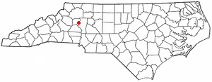
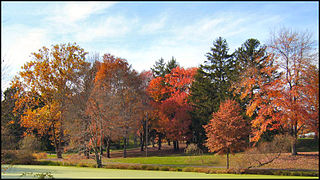
Stony Point is a census-designated place (CDP) in Alexander and Iredell counties in the U.S. state of North Carolina. The population was 1,317 at the 2010 census. It is part of the Hickory–Lenoir–Morganton Metropolitan Statistical Area.

References

  1. "ArcGIS REST Services Directory". United States Census Bureau. Retrieved October 12, 2022.
  2. "Census Population API". United States Census Bureau. Retrieved October 12, 2022.
  3. 1 2 "Geographic Identifiers: 2010 Census Summary File 1 (G001): Lemont CDP, Pennsylvania". U.S. Census Bureau, American Factfinder. Archived from the original on April 16, 2015. Retrieved April 16, 2015.
  4. "US Gazetteer files: 2010, 2000, and 1990". United States Census Bureau. February 12, 2011. Retrieved April 23, 2011.
  5. "Census of Population and Housing". Census.gov. Retrieved June 4, 2016.
  6. "U.S. Census website". United States Census Bureau . Retrieved January 31, 2008.
  7. "Friends of Lemont School". www.facebook.com. Retrieved July 1, 2017.
  8. "Plans made to construct new K-5 Houserville Elementary School". centredaily. Retrieved July 1, 2017.
  9. "State College Board Meeting Minutes June 16, 2017".