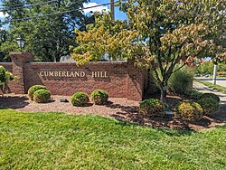
Ewing Township is a township in Mercer County, in the U.S. state of New Jersey. The township falls within the New York metropolitan area as defined by the U.S. Census Bureau. It borders the Philadelphia metropolitan area and is part of the Federal Communications Commission's Philadelphia Designated Market Area. As of the 2020 United States census, the township's population was 37,264, its highest decennial count ever and an increase of 1,474 (+4.1%) from the 35,790 recorded at the 2010 census, which in turn reflected an increase of 83 (+0.2%) from the 35,707 counted in the 2000 census.

Rancho Rinconada is a residential neighborhood in the eastern part of Cupertino, California. It is bordered by Saratoga Creek, Stevens Creek Boulevard, Miller Avenue and Bollinger Road. It is bordered by the West San Jose neighborhood to the east and south, central Cupertino to the west, and the city of Santa Clara to the north.

The Undue Subdivision of Land Prevention Act 1885 was an Act of the Parliament of Queensland that was passed to prevent overcrowding and urban degradation in cities and towns in Queensland, and especially in Brisbane. The Act is a noteworthy example of early efforts by Australian legislators to control urban development and avoid the appearance of slums.

Floor area ratio (FAR) is the ratio of a building's total floor area to the size of the piece of land upon which it is built. It is often used as one of the regulations in city planning along with the building-to-land ratio. The terms can also refer to limits imposed on such a ratio through zoning. FAR includes all floor areas but is indifferent to their spatial distribution on the lot whereas the building coverage ratio measures building footprint on the lot but is indifferent to building height.
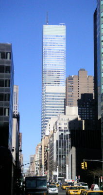
731 Lexington Avenue is a 1,345,489 sq ft (125,000.0 m2) mixed-use glass skyscraper on Lexington Avenue, on the East Side of Midtown Manhattan, New York City. Opened in 2004, it houses the headquarters of Bloomberg L.P. and as a result, is sometimes referred to informally as Bloomberg Tower. The building also houses retail outlets, restaurants and 105 luxury condominiums. The residence section of the building is known as One Beacon Court and is served by a separate entrance.

Union Square is a commercial and residential real estate project in Hong Kong on the West Kowloon reclamation. Covering 13.54 hectares, the site has a gross floor area of 1,090,026 square metres (11,732,940 sq ft), approximately the size of the Canary Wharf development in London. As of 2011, the site contained some of the tallest buildings in Hong Kong — including the tallest commercial building in Hong Kong, the 118-storey International Commerce Centre and the loftiest residential tower in Hong Kong, The Cullinan.

Sylvan Hills is a historic intown neighborhood in southwest Atlanta, Georgia, United States.
Westwood Highlands is a small affluent neighborhood located in south-central San Francisco, California, northeast of the intersection of Monterey Boulevard and Plymouth Avenue. It is bordered by Westwood Park to the south, Saint Francis Wood to the west, Sherwood Forest to the north, and Sunnyside to the east. Mt. Davidson, the highest point in San Francisco, lays just northeast.

The urban development patterns of Lexington, Kentucky, confined within an urban growth boundary that protects its famed horse farms, include greenbelts and expanses of land between it and the surrounding towns. This has been done to preserve the region's horse farms and the unique Bluegrass landscape, which bring millions of dollars to the city through the horse industry and tourism. Urban growth is also tightly restricted in the adjacent counties, with the exception of Jessamine County, with development only allowed inside existing city limits. In order to prevent rural subdivisions and large homes on expansive lots from consuming the Bluegrass landscape, Fayette and all surrounding counties have minimum lot size requirements, which range from 10 acres (40,000 m2) in Jessamine to fifty in Fayette.
Crestwood/Glen Cove is a community in Houston, Texas. It consists of the Crestwood and Glen Cove subdivisions. The Crestwood/Glen Cove Civic Club serves the Crestwood/Glen Cove community.
GameDay Center was a planned 15-story residential condominium at the corner of Broadway and West High Street in Lexington, Kentucky. The 188-unit project was planned by Gameday Centers LLC who had hoped to construct the tower to give University of Kentucky basketball fans a residence near Rupp Arena. Retail stores would have occupied the first floor, with a sports-themed restaurant on the second. Parking would have been located in an underground three-story garage.
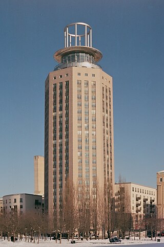
South Tower is a high-rise building located on Fatburstrappan 18, next to Fatbursparken on Södermalm in Stockholm. The building has a height of about 86 metres (282 ft) above the ground including the "crown" and consists of 25 floors. The Söder Torn complex contains three additional buildings, including one that abuts Medborgarplatsen. Collectively, the buildings contain 172 condominium apartments and 5 businesses. The South Tower itself has 85 apartments and one business. A garage contains parking for both cars and motorcycles.

Barton Hills is a neighborhood in Austin, Texas. It is located in south Austin, and encompasses part of ZIP code 78704.

The North Hills Historic District is a residential subdivision in north Knoxville, Tennessee, United States, that was added to the National Register of Historic Places in September 2008 as a historic district. The subdivision was established in 1927 by the North Hills Corporation as a neighborhood of custom-built homes, catering to middle-class families. The historic district includes 130 houses on about 50 acres (20 ha). At the time of its listing on the National Register, it was described by the Tennessee Historical Commission as a good example of mid-20th century residential architecture.
Beaumont Centre is a neighborhood and major retail and office park in southwestern Lexington, Kentucky, United States. Its boundaries are New Circle Road to the north, the older Harrods Hill neighborhood to the south, Man o' War Boulevard to the west, and Harrodsburg Road to the east. The area was one of the last undeveloped areas off New Circle Road, development began in the early 1990s.
Mason Headley is a neighborhood in southwestern Lexington, Kentucky, United States. Its boundaries are Mason Headley Road to the north, Laurel Hill Road to the south, Beacon Hill Drive to the west, and Cold Harbor Drive to the east.
Willow Oak is a neighborhood in southwestern Lexington, Kentucky, United States. It is a cul de sac community with only one entrance. Its boundary backs up to properties along Boston Road, Millpond Road, Wyndham Hills Drive, and Everetts Dale. Signs were placed on property this week stating no fishing and residents are enforcing the signs.
Andover Hills is a subdivision in southeastern Lexington, Kentucky, United States. Its boundaries are Todds Road to the east, Hays Boulevard to the south, Jacobson Park to the west, and Mapleleaf Park to the north. Schools in the district are Athens Chilesburg Elementary School, Edythe J. Hayes Middle School, and Henry Clay High School.
An executive home is a type of house that is intended to provide its occupant with higher-than-average levels of comfort, quality and convenience. It is a property which a person or family can afford to purchase later on, often using a combination of savings and mortgage financing. In the real estate industry the term commonly denotes large four to six bedroom houses, often older homes but sometimes high-cost new developments.

99 Hudson is a 79-story condominium in Jersey City, New Jersey. It is the tallest building in Jersey City and the state of New Jersey, and the 46th tallest building in the United States. It is also the tallest residential building in the United States outside of New York City and Chicago. Developed by China Overseas America, 99 Hudson is the first residential project in the U.S. for the firm. The 1.4 million square-foot building will include 781 condominium units ranging from studios to three bedrooms.