Related Research Articles
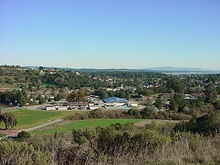
Soquel is an unincorporated town and census-designated place (CDP) in Santa Cruz County, California, located on the northern coast of Monterey Bay. The population was 9,980 at the 2020 census.

Fairway is a city in Johnson County, Kansas, United States. It is included in the Kansas City metropolitan area census designation and the Shawnee Mission postal services designation. As of the 2020 United States census, the city population was 4,170.

St. Charles is a planned community in Charles County, Maryland, United States. It is 22 miles (35 km) south-southeast of Washington, D.C., 24 miles (39 km) from northern Virginia and immediately south of Waldorf, which is the mailing address.. At the 2000 census, it was delineated as a census-designated place (CDP), with a population of 33,379. It was included in the Waldorf CDP for the 2010 census.
Clay is a town in Onondaga County, New York, United States. As of the 2020 Census, the population was 60,527, making it Syracuse's most populous suburb. The town was named after American attorney and statesman Henry Clay.
Kenwick is a neighborhood in southeastern Lexington, Kentucky, United States. Its boundaries are Sherman Avenue to the south, East Main Street to the west, railroad tracks to the north, and Richmond Avenue to the north.
Highland Parks is a neighborhood in northwest Lexington, Kentucky, United States. It is a new subdivision started in the mid-2000s, located between the older Highlands and Oakwood neighborhoods. It is located south of Birch Drive and north of Boxwood Drive. It is bounded by Georgetown Road to the west and Oakwood Park to the east.
Palomar Hills is a neighborhood in southwestern Lexington, Kentucky, United States. Its boundaries are Harrodsburg Road to the east, Man o' War Boulevard to the north, Bowman Mill Road to the south, and the Lexington urban growth boundary to the west.
Eastside is a neighborhood in southeastern Lexington, Kentucky, United States. Its boundaries are Walton Avenue to the north, CSX railroad tracks to the east, Richmond Avenue to the south, and Main Street to the west.
Southern Heights is a neighborhood in southwestern Lexington, Kentucky, United States. Its boundaries are the University of Kentucky Arboretum and Central Baptist Hospital to the north, Nicholasville Road to the west, and Edgemoor Drive/Blueberry Road to the south.
Rosemill is a neighborhood in southwestern Lexington, Kentucky, United States. Its boundaries are Southland Drive and Rosemont Garden to the north, Clays Mill Road to the west, and Hill-N-Dale Road to the south. Lexington Catholic High School has been located in the center of the neighborhood since 1957.
Spindletop is a rural neighborhood north of Lexington, Kentucky, United States. Its boundaries are I-75 to the west and Berea Road to the south and east. It is located just south of the Kentucky Horse Park. It is named for Spindletop hall, a historic mansion once owned by Miles Franklin Yount, which is located within the neighborhood.
North Elizabeth Street is a neighborhood in southwestern Lexington, Kentucky, United States. It is located just west of the University of Kentucky and most of its residents are college students.
Cross Keys is a neighborhood in southwestern Lexington, Kentucky, United States. Its boundaries are Traveler Road to the east, Versailles Road to the north, Parks Mill Road to the north, and Lane Allen Road to the south.
Elkhorn Park is a neighborhood in northern Lexington, Kentucky, United States. Its boundaries are Dover Road to the north, North Broadway to the east, New Circle Road to the south, and Russell Cave Road to the west.
Highlands is a neighborhood in northwestern Lexington, Kentucky, United States. Its boundaries are Georgetown Road to the west, Oakwood Park to the east, and Citation Boulevard to the east. There are plans to develop a vacant field north of Highlands, it is unclear whether it will become part of Highlands or be a separate neighborhood.
Oakwood is a neighborhood in northwestern Lexington, Kentucky, United States. Its boundaries are Georgetown Road to the west, Oakwood Park to the east, the Nandino Parkway industrial complex to the south, and the newer Highland Park neighborhood to the north.
South Point is a neighborhood in southeastern Lexington, Kentucky, United States. Its boundaries are Nicholasville Road to the west, the Jessamine County line to the south, the newer Waterford neighborhood to the east, and Waveland Museum Lane to the north.
Tanbark is a neighborhood in southeastern Lexington, Kentucky, United States. Its boundaries are Man o' War Boulevard to the north, Tates Creek Road to the west, Hartland Parkway to the south, and Rapid Run Drive to the east.
Belleau Woods is a neighborhood in southeastern Lexington, Kentucky, United States. Its boundaries are Man o' War Boulevard to the south, Hickman Creek to the north and east, and a combination of Belleau Woods Drive and Greenfield Drive to the west. This neighborhood features a volunteer neighborhood association, the Belleau Wood Neighborhood Association.

Pemberwick is a neighborhood/section and census-designated place in Greenwich in Fairfield County, Connecticut, United States. As of the 2010 census it had a population of 3,680.
References
- 1 2 Fairway Neighborhood Profile Retrieved 2013-06-01.


| | This Fayette County, Kentucky state location article is a stub. You can help Wikipedia by expanding it. |