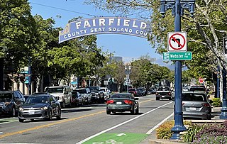
Fairfield is a city in and the county seat of Solano County, California, United States, in the North Bay sub-region of the San Francisco Bay Area. It is generally considered the midpoint between the cities of San Francisco and Sacramento, approximately 40 miles (64 km) from the city center of each city, the same from the city center of Oakland.

Wellston is a city in St. Louis County, Missouri, United States, along the northwest border of the city of St. Louis. The population was 2,313 at the 2010 census.

Clayton is a city in and the county seat of St. Louis County, Missouri, and borders the independent city of St. Louis. The population was 17,355 at the 2020 census. Organized in 1877, the city was named after Ralph Clayton, who donated the land for the St. Louis County courthouse.

Calverton is an unincorporated area and census-designated place located on the boundary between Montgomery and Prince George's counties, Maryland, in the United States. At the 2020 census, it had a population of 17,316.
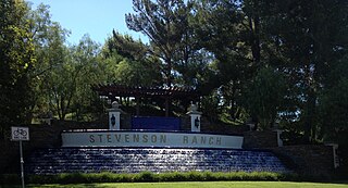
Stevenson Ranch is an unincorporated community in the Santa Clarita Valley of Los Angeles County, California. Stevenson Ranch is set in the foothills of the Santa Susana Mountains and lies west of Interstate 5 and the city of Santa Clarita. Stevenson Ranch encompasses about 6.4 square miles (17 km2). About 1,000 acres (4.0 km2) are set aside as parks, recreation areas, and open space. A master-planned community, it was approved by the county in 1987. The population was 20,178 at the time of the 2020 census. For statistical purposes, the Census Bureau has designated it a census-designated place (CDP).
Bryan Station is a neighborhood in Northeast Lexington, Kentucky, United States. It is named after the nearby pioneer settlement by the same name located just 2 miles (3 km) outside the current edge of the city.
Joyland is a neighborhood in Northeast Lexington, Kentucky, United States. Its boundaries are I-75/ I-64 to the south, Paris Pike to the east, Russell Cave Road to the west, and the Lexington Urban Growth Boundary to the north. Joyland is the only north Lexington neighborhood to be located entirely north of I-75.
Garden Springs is a neighborhood in Southwestern Lexington, Kentucky, United States. Its boundaries are Georgian Way to the west, Lane Allen Road to the north, Harrodsburg Road to the east, and New Circle Road to the south. Turfland Mall and the Lexington campus of Sullivan University are located in the neighborhood.
Palomar Hills is a neighborhood in southwestern Lexington, Kentucky, United States. Its boundaries are Harrodsburg Road to the east, Man o' War Boulevard to the north, Bowman Mill Road to the south, and the Lexington urban growth boundary to the west.
Copperfield is a neighborhood in southwestern Lexington, Kentucky, United States. Its boundaries are the Jessamine County line to the south, Clays Mill Road to the east, Twain Ridge Road to the north, and Calevares Drive to the west.
Colony is a neighborhood in southwestern Lexington, Kentucky, United States. Its boundaries are Parkers Mill Road to the south and east, Versailles Road to the north, and New Circle Road to the west.
Cross Keys is a neighborhood in southwestern Lexington, Kentucky, United States. Its boundaries are Traveler Road to the east, Versailles Road to the north, Parks Mill Road to the north, and Lane Allen Road to the south.

Northside is a neighborhood in northern Lexington, Kentucky, United States. Its boundaries are Loudon Avenue to the north and east, Short Street, Midland Avenue, and Winchester Road to the south, and Newtown Pike to the west.
Meadowthorpe is a neighborhood in western Lexington, Kentucky, United States. Its boundaries are Leestown Road to the south, New Circle Road to the west, and Norfolk Southern railroad tracks to the north and east. Since 2000, areas south of Leestown Road have seen residential and commercial development in Townley Center. This area is not a part of the Meadowthorpe neighborhood. Schools in the area are Meadowthorpe Elementary and Leestown Middle School.
Radcliffe is a neighborhood in northern Lexington, Kentucky, United States. It is alternatively called Marlboro. Its boundaries are Dover Road to the south, Paris Pike to the east, Russell Cave Road to the west, and I-75/ I-64 to the north.

Calumet is a neighborhood in northern Lexington, Kentucky, United States. Its boundaries are Viley Road to the west, Versailles Road to the south, New Circle Road to the north, and Wolf Run Creek to the east.
Highlands is a neighborhood in northwestern Lexington, Kentucky, United States. Its boundaries are Georgetown Road to the west, Oakwood Park to the east, and Citation Boulevard to the east. There are plans to develop a vacant field north of Highlands, it is unclear whether it will become part of Highlands or be a separate neighborhood.
Oakwood is a neighborhood in northwestern Lexington, Kentucky, United States. Its boundaries are Georgetown Road to the west, Oakwood Park to the east, the Nandino Parkway industrial complex to the south, and the newer Highland Park neighborhood to the north.
Brigadoon is a neighborhood in southeastern Lexington, Kentucky, United States. its boundaries are Reynolds Road to the north, Lansdowne Drive to the east, Wilson Downing Road to the south, and Nicholasville Road to the west.
Idle Hour is a neighborhood in southeastern Lexington, Kentucky, United States. Its boundaries are Idle Hour Country Club to the north, CSX railroad tracks to the east, New Circle Road to the south, and Richmond Road to the west.