Related Research Articles

Lakeview is a census-designated place (CDP) in Riverside County, California, United States. The population was 2,104 at the 2010 census, up from 1,619 at the 2000 census. The community is named for nearby Mystic Lake.

Emerald Lake Hills or Emerald Hills is a census-designated place and neighborhood in unincorporated San Mateo County, in the state of California, United States. Situated among oak-studded hills between Woodside, Redwood City, and San Carlos roughly bounded by Edgewood Road, Alameda de las Pulgas, Farm Hill Boulevard, and Interstate 280. The population was 4,406 at the 2020 census and the per-capita income was $68,966, making it the 22nd wealthiest place in California and the 82nd highest income places in the United States
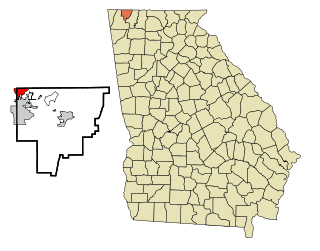
Lakeview is a census-designated place (CDP) in Catoosa and Walker counties in the U.S. state of Georgia. The population was 4,820 at the 2000 census and 4,777 at the 2020 census. It is part of the Chattanooga, TN–GA Metropolitan Statistical Area.

Lakeview Heights is a home rule-class city in Rowan County, Kentucky, in the United States. The population was 251 as of the year 2000 U.S. census.
Cato Township is a civil township of Montcalm County in the U.S. state of Michigan. The population was 2,898 at the 2020 census.

Lakeview is a village in Cato Township in Montcalm County of the U.S. state of Michigan. The population was 1,024 at the 2020 census.

Lakeview is a hamlet and census-designated place (CDP) in the Town of Hempstead in Nassau County, on Long Island, in New York, United States. The population was 6,077 at the 2020 census.

Lakeview is a village in Logan County, Ohio, United States. The population was 1,184 at the 2020 census.

Lakeview is a town in Lake County, Oregon, United States. The population was 2,418 at the 2020 census. It is the county seat of Lake County. The city bills itself as the "Tallest Town in Oregon" because of its elevation, 4,757 feet (1,450 m) above sea level. Lakeview is situated in the Goose Lake Valley at the foot of the Warner Mountains and at the edge of Oregon's high desert country. Its economy is based on agriculture, lumber production, and government activities. In addition, tourism is an increasingly important part of the city's economy. Oregon's Outback Scenic Byway passes through Lakeview.

Lakeview is a town in Hall County, Texas, United States. The population was 107 at the 2010 census, down from 152 at the 2000 census.

El Lago is a city in Harris County, Texas, United States. The population was 3,090 at the 2020 census.
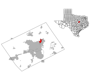
Lacy Lakeview is a city in McLennan County, Texas, United States. It is part of the Waco Metropolitan Statistical Area. The population was 6,988 at the 2020 census. The city's name is sometimes spelled with a hyphen, but the official spelling omits the hyphen.

Lakeview, also spelled Lake View, is one of the 77 community areas of Chicago, Illinois. Lakeview is located in the city's North Side. It is bordered by West Diversey Parkway on the south, West Irving Park Road on the north, North Ravenswood Avenue on the west, and the shore of Lake Michigan on the east. The Uptown community area is to Lakeview's north, Lincoln Square to its northwest, North Center to its west, and Lincoln Park to its south. The 2020 population of Lakeview was 103,050 residents, making it the second-largest Chicago community area by population.

Navarre is a neighborhood of the city of New Orleans. A subdistrict of the Lakeview District Area, its boundaries as defined by the City Planning Commission are: I-610, Canal Boulevard and Florida Boulevard to the north, Orleans Avenue to the east, City Park Avenue to the south and the Pontchartrain Expressway and Pontchartrain Boulevard to the west.

Lakeview is a neighborhood of the city of New Orleans. A subdistrict of the Lakeview District Area, its boundaries as defined by the City Planning Commission are: Allen Toussaint Boulevard to the north, Orleans Avenue to the east, Florida Boulevard, Canal Boulevard and I-610 to the south and Pontchartrain Boulevard to the west. Lakeview is sometimes used to describe the entire area bounded by Lake Pontchartrain to the north, the Orleans Avenue Canal to the east, City Park Avenue to the south and the 17th Street Canal to the west. This larger definition includes the West End, Lakewood and Navarre neighborhoods, as well as the Lakefront neighborhoods of Lakeshore and Lake Vista.

City Park is a neighborhood of the city of New Orleans, US. A subdistrict of the Lakeview District Area, its boundaries as defined by the City Planning Commission are: Allen Toussaint Boulevard to the north, Bayou St. John to the east, Orleans Avenue, North Carrollton Avenue and Toulouse Street to the south and City Park and Orleans Avenues to the west. The neighborhood is named after and dominated by City Park.
Lakeshore/Lake Vista is a neighborhood of the city of New Orleans, Louisiana. A subdistrict of the Lakeview District Area, its boundaries as defined by the City Planning Commission are: Lake Pontchartrain to the north, Bayou St. John to the east, Allen Toussaint Boulevard to the south and Pontchartrain Boulevard and the New Basin Canal to the west. The neighborhood is composed of the Lakeshore and Lake Vista subdivisions, built on land reclaimed from Lake Pontchartrain. The Lakefront is a term sometimes used to name the larger neighborhood created by the Orleans Levee Board's land reclamation initiative in early 20th century New Orleans; it includes Lakeshore and Lake Vista, as well as Lakeshore Drive and the lakefront park system, the University of New Orleans, Lake Terrace, and Lake Oaks.

Lakewood is a neighborhood of the city of New Orleans. A subdistrict of the Lakeview District Area, its boundaries as defined by the City Planning Commission are: Veterans Memorial Boulevard to the north, Pontchartrain Boulevard and the Pontchartrain Expressway to the east, Last, Quince, Hamilton, Peach, Mistletoe, Dixon, Cherry and Palmetto Streets to the south and the 17th Street Canal to the west.
Shriners is a neighborhood in southeastern Lexington, Kentucky, United States. It takes its name from the Shriners Hospital for Children located within it. Its boundaries are Richmond Road to the east, Chinoe Road to the north, Cooper Drive to the west, and Lakeview Drive to the south.

Chippewa Park is a census-designated place in Stokes Township, Logan County, Ohio, United States. As of the 2020 census, the population was 819.
References
- 1 2 Lakeview Islands Neighborhood Profile Retrieved 2013-06-04.


| | This Fayette County, Kentucky state location article is a stub. You can help Wikipedia by expanding it. |