East York

Last updated

East York
East York Pano 2023.jpg
Don Valley Parkway in East York
EYLogo.svg
EYLogo.svg
East York locator.png
Location of East York (red) compared to the rest of Toronto.
Coordinates: 43°41′28.68″N79°19′40.08″W / 43.6913000°N 79.3278000°W / 43.6913000; -79.3278000
CountryCanada
Province Ontario
Municipality Toronto
IncorporatedJanuary 1, 1924 (Township)
January 1, 1967 (Borough)
Changed Region1953 Metropolitan Toronto from York County
AmalgamatedJanuary 1, 1998 into Toronto
Government
  Councillors Brad Bradford
Paula Fletcher
Jaye Robinson
  Governing Body Toronto City Council
  MPs Julie Dabrusin (Liberal)
Nathaniel Erskine-Smith (Liberal)
Rob Oliphant (Liberal)
   MPPs Mary-Margaret McMahon (LIB)
Peter Tabuns (NDP)
Stephanie Bowman (LIB)
Area
  Total21.26 km2 (8.21 sq mi)
Population
 (2016)
  Total118,071
  Density5,553.7/km2 (14,384/sq mi)
Time zone UTC-5 (EST)
  Summer (DST) UTC-4 (EDT)
Postal code span
M4B, M4C, M4E, M4G, M4H, M4J, M4K
Area code(s) 416, 647, and 437

East York is a district and former municipality within Toronto, Ontario, Canada. From 1967 to 1998, it was officially the Borough of East York, a borough within the upper-tier municipality of Metropolitan Toronto. The borough was dissolved in 1998 when it was amalgamated with the other lower-tier municipalities of Metropolitan Toronto to form the new "megacity" of Toronto. Prior to its amalgamation, East York was Ontario's last remaining borough.

Contents

It is separated by the Don River from the former City of Toronto. Traditional East York is southeast of the river, and the neighbourhoods of Leaside, Bennington Heights and densely populated Thorncliffe Park are northwest of the river. The heart of East York is filled with middle-class and working-class homes.

History

East York was originally part of York Township, Ontario. Following the incorporation of the Township of North York in 1922, York Township was divided by Toronto, Leaside and North Toronto. With the rapid growth that followed the opening of the Bloor-Danforth (Prince Edward) Viaduct in 1918, the residents of the eastern half of York Township (as an exclave of the western half) felt they had been neglected by the township when it came to roads, sewers and other municipal services. Left with the option to either join the City of Toronto or branch out on its own, 448 East Yorkers voted to incorporate a new township, while 102 voted to amalgamate with Toronto. The Township of East York was incorporated on January 1, 1924 with a population of 19,849. The western half of York Township retained its name.

East York was originally populated by working-class English people who valued the opportunity to own small homes of their own, with front lawns and back gardens. Many had immigrated from Lancashire and Yorkshire. In 1961, 71.7% of the population identified themselves as having British origins.

In the late 1940s, after World War II, East York became home to many returning veterans and their families. Many inexpensive homes were built, including the houses around Topham Park, by the government, to house the returning veterans and the baby boomers. The local government was both socially conscious and frugal, fitting the residents' self-image of East York as filled with supportive neighbours and non-government organizations.[ citation needed ]

Post-war bungalows built in East York after World War II. O'Connor-Parkview houses.JPG
Post-war bungalows built in East York after World War II.

For many years, East York did not allow the serving of alcoholic beverages in any restaurants, etc. The result was a heavy concentration of alcohol-serving restaurants and bars on Danforth Avenue, the main street in the city of Toronto running east–west just south of East York. The prohibition of serving alcohol was eliminated in the 1970s. [1]

The borough of East York was established in 1967 through the amalgamation of the former township of East York and the former town of Leaside. Leaside was a planned industrial and residential community. East York has over the years been a residential enclave for senior citizens, as the original owners from the 1940s age and as younger families move out to suburbs to live in larger houses. East York had its own fire department with three stations, which are still in operation today under the combined Toronto Fire Services. Recently, rapid and accelerated gentrification has changed many neighbourhoods. Many one-story bungalows have added second floors, and many shops have been converted to more upscale shops. Canada's only borough, East York was semi-autonomous within the greater municipality of Metropolitan Toronto.

In 1998, Metro Toronto and its constituent municipalities were dissolved and replaced by the new "megacity" of Toronto. East York's last mayor was Michael Prue who went on to become city councillor for East York, and then a Member of Provincial Parliament for Beaches—East York in 2001. Between 2002 and 2005, the East York Civic Centre's "True Davidson Council Chamber" was used to hold the Toronto Computer Leasing Inquiry/Toronto External Contracts Inquiry.

During the COVID-19 pandemic, many residents of East York stood up against illegal rent increases. This came in the form of protests, [2] rent strikes, and community organizing. [3]

Geography

East York is located not far from the mouth of the Don River. The municipality borders Scarborough to the east, Old Toronto to the west, and North York to the north. East York is located north of Danforth Avenue between the Don River and Victoria Park Avenue.

Demographics

Visible Minorities, 2006 Archived January 19, 2016, at the Wayback Machine PopulationPercent
South Asian 19,31517.4
Chinese 6,8706.2
Filipino 4,6254.2
Black 4,5104.1
West Asian/Arab 2,5102.3
Latin American 8350.8
Southeast Asian 7150.6
Korean 6300.6
Japanese6100.5
Other visible minorities, n.i.e.Profile statcan.ca [ permanent dead link ]1,7351.5

East York's population was 115,185 in 2001. [4] By the 2006 census, the population had dropped slightly (−2.7%), to 112,054. [nb 1]

Crescent Town is home to a number of residents who immigrated to Canada. Crescent Town.jpg
Crescent Town is home to a number of residents who immigrated to Canada.

Since the 1970s, the population composition has changed from predominantly British, as East York has become a major arrival point for immigrants, many of whom have established their first Canadian residence in the apartments that became plentiful in Thorncliffe Park, Crescent Town and elsewhere on or near main streets. Almost half of the population in 2001 (45.1%) was foreign-born, and of these, 49.0% had immigrated to the area between 1991 and 2001. Archived January 19, 2016, at the Wayback Machine These groups include Bengalis, Indians, Pakistanis, Jamaicans, Filipinos and Sri Lankans. East York also has a well established Greek population and a growing Chinese community. In 2006 the percentage of visible minorities was 38.4%, and the percentage of immigrants was 44.4%.

The religious affiliations of the East York population are consistent with its ethnic composition. Some 63.4% of the population adheres to Christianity, with an almost even split between Catholics (23.6%) and Protestants (25.3%). Christian Orthodox and unspecified types of Christianity make up 12.0% and 2.5% respectively. The largest non-Christian religious group is Muslim, who make up 12.6% of religious adherents, followed by Hinduism (3.7%), Buddhism (1.6%), and Judaism (0.9%). A sizable percentage of the population (17.1%) has no religious affiliation. Archived January 19, 2016, at the Wayback Machine

There is also Estonian House which is the unofficial Estonian Consulate in Toronto. The building houses banquets, social events, and an Estonian school. [5] [6]

While English is the dominant language in the area, nearly half (42.6%) of the population reports that their first language was neither English nor French.

Education

East York Collegiate Institute is one of several public secondary schools located in East York. East York Collegiate.JPG
East York Collegiate Institute is one of several public secondary schools located in East York.

Four public school boards provide primary and secondary education for residents of East York, Conseil scolaire catholique MonAvenir (CSCM), Conseil scolaire Viamonde (CSV), the Toronto Catholic District School Board (TCDSB), and the Toronto District School Board (TDSB). CSV and TDSB operate as secular public school boards, the former operating French first language institution, whereas the latter operated English first language institutions. The other two school boards, CSCM and TCDSB, operate as public separate school boards, the former operating French first language separate schools, the latter operating English first language separate schools.

The East York Board of Education was the former authority of English secular schools in East York, until East York was amalgamated into the City of Toronto in 1998. The Metropolitan Separate School Board managed all separate schools (English and French) until 1998, when the school board was reorganized into CSCM and TCDSB.

In addition to primary and secondary education institutions, East York is also home to a campus operated by Centennial College. The college is a post-secondary institution with campuses located throughout Toronto.

Sports

East York is home to various sports teams. The hockey teams are the Bulldogs, playing in East York Arena, Victoria Village, playing in Victoria Village arena and the Flames, playing in Leaside Memorial Community Gardens. All three leagues offer co-ed (boys and girls) entry level and competitive select hockey for various ages, being played in the North York Hockey League.[ citation needed ] The East York Lyndhursts represented the Canada men's national ice hockey team at the 1954 Ice Hockey World Championships. [7]

East York is home to East York Soccer, playing at East York Collegiate, Clairlea Soccer, playing at various locations and the Leaside-East Toronto Soccer Club, playing at Leaside High School and Flemingdon, who offer entry level and competitive soccer for all ages. East York is represented by East York City FC in soccer. East York is home to baseball organizations such as East York and Topham Park. East York provides entry level and AAA baseball for all ages, while Topham Park provides entry level and competitive select softball. East York is home to a provincially known figure skating club, a gymnastics club, a lawn bowling club, and a curling club. East York has a skateboarding community group, Team EY, who collaborated with the local skateboarding community to build the East York Skatepark in 2007. [8]

Leaside Memorial Community Gardens, the largest recreation centre in Leaside, provides an indoor swimming pool, an ice rink, a curling rink and a large auditorium.[ citation needed ]

See also

Related Research Articles

<span class="mw-page-title-main">Etobicoke</span> District of Toronto, Ontario, Canada

Etobicoke is an administrative district and former city within Toronto, Ontario, Canada. Comprising the city's west-end, Etobicoke is bordered on the south by Lake Ontario, on the east by the Humber River, on the west by Etobicoke Creek, the cities of Brampton, and Mississauga, the Toronto Pearson International Airport, and on the north by the city of Vaughan at Steeles Avenue West.

<span class="mw-page-title-main">Leaside</span> Neighbourhood in Toronto, Ontario, Canada

Leaside (/'liːˌsaɪd/) is a neighbourhood in Toronto, Ontario, Canada. It is located northeast of Downtown Toronto, in the vicinity of Eglinton Avenue East and Bayview Avenue. The area takes its name from William Lea and the Lea family, who settled there in the early years of the 19th century. The area first developed as farmland along with Toronto through the 19th century. It was incorporated as a town in 1913. In 1967, it amalgamated with the township of East York to form the borough of East York. In 1998, it became part of the city of Toronto. It is one of the most expensive and exclusive neighbourhoods in the city.

<span class="mw-page-title-main">Port Union, Toronto</span> Neighbourhood in Toronto, Ontario, Canada

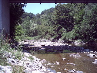
Port Union, also known as Centennial Scarborough is a neighbourhood in Toronto, Ontario, Canada. It is located in the south-east corner of Toronto, within the former suburb of Scarborough. The neighbourhood is bounded by Kingston Road to the north, Port Union Road to the east, the Lake Ontario shoreline to the south, and Highland Creek to the west.

<span class="mw-page-title-main">Wexford, Toronto</span> Neighbourhood in Toronto, Ontario, Canada

Wexford is a neighbourhood in Toronto, Ontario, Canada. It is located in the eastern part of the city, on the western end of the district of Scarborough, spanning Lawrence Avenue East between Victoria Park Avenue and Birchmount Road. There are many persons of Greek heritage in this neighbourhood. The Wexford Heights Business Improvement Area boasts 245 members and hosts an annual street festival on Lawrence.

<span class="mw-page-title-main">Willowdale, Toronto</span> Neighbourhood in Toronto, Ontario, Canada

Willowdale is a neighbourhood in the city of Toronto, Ontario, Canada, located in the district of North York. It developed from three postal villages: Newtonbrook, Willowdale and Lansing.

<span class="mw-page-title-main">Henry Farm</span> Neighbourhood in Toronto, Ontario, Canada

Henry Farm is a neighbourhood in the City of Toronto, Ontario, Canada. It is located in the north central part of the city within the former city of North York.

<span class="mw-page-title-main">Bathurst Manor</span> Neighbourhood in Toronto, Ontario, Canada

Bathurst Manor is a neighbourhood of Toronto, Ontario, Canada, located in northern Toronto in the former suburb of North York. It sits on a plateau bounded on the north by Finch Avenue West, on the west by Dufferin Street, on the east by the Don River, and on the south by Sheppard Avenue West. The area is also regarded as part of the Downsview postal area as designated by Canada Post. It is part of the former city of North York, which merged with five other municipalities and a regional government to form the new "City of Toronto" in 1998. It is part of the federal and provincial electoral district York Centre, and Toronto electoral ward 10: York Centre (East). In 2006, it had a population of 14,615.

<span class="mw-page-title-main">Richview, Toronto</span> Neighbourhood in Toronto, Ontario, Canada

Richview, formally known as Willowridge-Martingrove-Richview, is a neighbourhood in the city of Toronto, Ontario, Canada. It is bounded on the west by Highway 401 and on the north by the highway and by Dixon Road, Royal York Road on the east, and Eglinton Avenue West along the south. Richview was originally established as a postal village within the then-agricultural Etobicoke Township, which later became the suburb of Etobicoke.

<span class="mw-page-title-main">Brockton Village</span> Neighbourhood in Toronto, Ontario, Canada

Brockton Village is a former town, and now the name of a neighbourhood, in Toronto, Ontario, Canada. It comprises a section of the old Town of Brockton which was annexed by the City of Toronto in 1884.

<span class="mw-page-title-main">Humber Summit</span> Neighbourhood in Toronto, Ontario, Canada

Humber Summit is a neighbourhood in Toronto, Ontario, Canada. It is one of the northernmost neighbourhoods in Toronto, located in the North York district of the city. It is bounded by Steeles Avenue to the north, Highway 400 to the east, Finch Avenue to the south, and follows the Humber River to the west.

<span class="mw-page-title-main">Humbermede</span> Neighbourhood in Toronto, Ontario, Canada

Humbermede, often called Emery, is a neighbourhood of Toronto, Ontario, Canada. Humbermede, like many of the "Humber" neighbourhoods in the city, gets its name from the Humber River. It is bounded on the west by the Humber River, on the north by Finch Avenue West, on the east by the Highway 400 and on the south by Sheppard Avenue West.

Amesbury or Brookhaven-Amesbury is a neighbourhood in Toronto, Ontario, Canada. The neighbourhood is located in northern Toronto in the former suburb of North York. It is part of federal and provincial electoral district York South—Weston, and Toronto electoral wards 11: York South—Weston (West) and 12: York South—Weston (East).

<span class="mw-page-title-main">Clanton Park, Toronto</span> Neighbourhood in Toronto, Ontario, Canada

Clanton Park is a neighbourhood in Toronto, Ontario, Canada. Located in the district of North York, it is part of federal and provincial electoral district York Centre, and Toronto electoral wards 9: York Centre (West) and 10: York Centre (East). In 2016, it had a population of 16,472, a 12.7% rise from 2011.

<span class="mw-page-title-main">Westminster-Branson</span> Neighbourhood in Toronto, Ontario, Canada

Westminster-Branson is a neighbourhood in the city of Toronto, Ontario, Canada. It is in the northernmost part of the city within the area of North York.

<span class="mw-page-title-main">Parkwoods</span> Neighbourhood in Toronto, Ontario, Canada

Parkwoods or sometimes referred to as Parkwoods-Donalda, is a neighbourhood in Toronto, Ontario, Canada. It is a geographically large neighbourhood located just south of Ontario Highway 401, west of Victoria Park Avenue, north of Lawrence Avenue East and east of the Don Valley Parkway.

<span class="mw-page-title-main">Pleasant View, Toronto</span> Neighbourhood in Toronto, Ontario, Canada

Pleasant View is a neighbourhood in the city of Toronto, Ontario, Canada that is located in the district of North York at the northern end of the city. It is bordered by Victoria Park to the East, Sheppard Avenue to the South, Highway 404 to the west and the Finch hydro corridor to the north. The neighbourhood is home to several high-rise apartment and condominium buildings, such as The Clippers.

<span class="mw-page-title-main">Clairlea</span> Neighbourhood in Toronto, Ontario, Canada

Clairlea is a safe, quiet, middle to upper-middle income neighbourhood in Toronto, Ontario, Canada that features well treed streets and detached homes with large backyards. The neighbourhood is located in east Toronto just east of Victoria Park Avenue.

<span class="mw-page-title-main">Scarborough Junction</span> Neighbourhood in Toronto, Ontario, Canada

Scarborough Junction is a small neighbourhood in the Scarborough district of Toronto, Ontario, Canada. It is bordered by Birchmount Road, Brimley Road, Eglinton Avenue, and St. Clair Avenue. Scarbrough Junction has an approximated population of 20,000. The population consists of 1/4 Caucasian, 2/4 Asian and 1/4 other

<span class="mw-page-title-main">Upper Beaches</span> Neighbourhood in Toronto, Ontario, Canada

The Upper Beaches is a neighbourhood in Toronto, Ontario, Canada. It is directly north of the Beaches area. It stretches from Coxwell Avenue in the west to Victoria Park in the east. The southern border is Kingston Road, while the northern boundary is generally considered to be the Canadian National Railway tracks between Gerrard Street and Danforth Avenue. The western part of the area was originally called Norway, and the larger area was once part of the Town of East Toronto. The name "Upper Beaches" was first used by developers and real estate agents around the period of 2001 to 2003 for the selling of houses on redeveloped land in the area, and was used as a marketing tag to attract buyers. The area was never considered part of the Beaches neighbourhood but was close to it. The city's current name for this area is East End Danforth, though that is rarely used. The city also includes the buildings along and just north of Danforth Avenue in the neighbourhood. The western portion between Woodbine Avenue and Coxwell is referred to by the city as Woodbine Corridor.

<span class="mw-page-title-main">Maple Leaf, Toronto</span> Neighbourhood in Toronto, Ontario, Canada

Maple Leaf is a neighbourhood in the city of Toronto, Ontario, Canada. It is located in the southwest of the North York district. Its approximate borders are Lawrence Avenue to the south, Culford Road to the west, Highway 401 to the north, and the CNR rail lines east of Keele Street to the east.

References

Notes

  1. As East York is no longer a separate municipality, Statistics Canada no longer reports its population (or other statistics). The total population was obtained for this article by summing the census tracts that comprised East York before 2006.

Citations

  1. Davidson, True. 1976. The Golden Years of East York. Toronto: Centennial College Press.
  2. "Tenants protest outside east-end Toronto building, say landlords using loophole to raise rent | CBC News".
  3. "Apartment tenants in East York protest proposed rent increases, evictions | The Star". Toronto Star . April 20, 2021.
  4. "2001 Census Data for East York". Archived from the original on January 19, 2016. Retrieved July 6, 2006.
  5. "Estonian House :: Contact". Archived from the original on October 27, 2010. Retrieved November 12, 2010.
  6. "Toronto Estonian House". Archived from the original on January 15, 2022. Retrieved November 12, 2010.
  7. Millson, Larry (March 1, 2004). "Lyndhursts' heartache hasn't diminished". The Globe and Mail. Retrieved February 20, 2020.
  8. East York Park Archived July 15, 2012, at the Wayback Machine eyskate.com

Further reading