Guildwood

Last updated

Guildwood
Neighbourhood
Guild Park and Gardens (38433008876).jpg
View of the Guild Inn
Guildwood map.PNG
Location of Guildwood within Toronto
Coordinates: 43°44′51″N79°11′58″W / 43.74750°N 79.19944°W / 43.74750; -79.19944
CountryFlag of Canada (Pantone).svg  Canada
ProvinceFlag of Ontario.svg  Ontario
City Toronto
Established municipality1850 Scarborough Township
Developed1957 (Subdivision)
Changed municipality1998 Toronto from City of Scarborough
Government
   MP John McKay (Scarborough-Guildwood)
   MPP Andrea Hazell (Scarborough—Guildwood)
   Councillor Paul Ainslie (Ward 43 Scarborough East)
Population
  TotalPopulation(census tract 0,331.03) is 5,267 residents in 2,006 and 5,912 residents in 2,011. Population growth 12% between 2,006−2,011. Statistics Canada2,006; Statistics Canada 2,011

Guildwood, also known as Guildwood Village, [1] is a residential neighbourhood in Toronto, Ontario, Canada. It is located in the eastern area of the city, in the district of Scarborough. It is bounded by the Scarborough Bluffs, south of Kingston Road, from Grey Abbey Trail in the east. [2]

Contents

History

Its oldest building is the 18th century Osterhout Log Cabin situated along the bluffs. The log cabin is one of Toronto's oldest buildings still standing, although its exact date of construction is unknown.

The Guild Inn in 1956, two years after it was acquired by Metropolitan Toronto. Guild Inn 1956.jpg
The Guild Inn in 1956, two years after it was acquired by Metropolitan Toronto.

In 1914, the Guild Inn was opened. Initially a private residence, it later became an art colony, and a hotel. From 1941 to 1947, the inn was leased by the Government of Canada as a base for the Women's Royal Naval Service, HMCS Bytown II, and later a military hospital.

After Metropolitan Toronto was formed in 1954, taxes on the Guild Inn property increased to the point that the owners Rosa and Spencer Clark decided to sell 450 acres (180 ha) of their property, which became the basis for the Guildwood Village subdivision. The Clarks remained involved with the development of the subdivision, in its design and layout to preserve as many trees in the area as possible. Development started in 1957 with the famous "Avenue of Homes" display of upscale homes. [3] The community introduced a number of new ideas in subdivision design, including winding roads and cul-de-sacs to reduce through traffic, and underground power and phone lines. "Rear-lot parks were modelled after English footpaths as walkways within the community." [4]

The Clarks helped design the entrance gates to the subdivision. After most of Toronto's Stanley Barracks (New Fort York) was demolished in 1953, its gates were salvaged and re-erected at the entrance to Guildwood Village. These gates, now called the "Guildwood Gates" still provide a unique and grand entrance to the community at the corner of Kingston Road and Guildwood Parkway. 43°44′58″N79°12′20″W / 43.74944°N 79.20556°W / 43.74944; -79.20556 (Gates%20of%20Guildwood)

Guild Park is famous for its historical architectural fragments [5] from the façades of demolished buildings in Downtown Toronto. Just west of the Guild Inn is Sir Wilfrid Laurier Collegiate Institute.

Guildwood Village Flag

Guildwood Village Flag in Guild Park with Toronto Mayor John Tory, Councillor Paul Ainslie and Friends of Guild Park President John Mason. Photo by Guildwoodian. GuildwoodVillageFlagToryAinslieMason.jpg
Guildwood Village Flag in Guild Park with Toronto Mayor John Tory, Councillor Paul Ainslie and Friends of Guild Park President John Mason. Photo by Guildwoodian.

The Guildwood Village Flag [6] was designed by Marsha Leverock Westergaard and was adopted by the Guildwood Village Community Association (GVCA) on June 12, 2018. The Guildwood Village flag can be seen flying in Guildwood Village from cars, store windows and residential flag poles.

The flag has deep meaning in its symbols and colours. The four quadrants read Guild – Wood – Village – on the Bluffs and represent Guildwood Village’s rich history of arts and culture, the abundant woods and green spaces, unique mid-century architecture, the Scarborough bluffs and a strong, vibrant Guildwood Village community.

Education

Sir Wilfrid Laurier Collegiate Institute is a public secondary school situated in Guildwood. Sir Wilfrid Laurier Collegiate Institute, Scarborough.jpg
Sir Wilfrid Laurier Collegiate Institute is a public secondary school situated in Guildwood.

The Toronto District School Board (TDSB) is a secular public school board that operates several schools in the neighbourhood, including one secondary school, Sir Wilfrid Laurier Collegiate Institute. In addition to Sir Wilfrid Laurier, TDSB also operates several elementary schools in Guildwood. They include:

Other public school boards that provides schooling for students in Guildwood include the Conseil scolaire Viamonde (CSV), Conseil scolaire catholique MonAvenir (CSCM), and the Toronto Catholic District School Board (TCDSB). CSV is a French-based secular public school board, whereas CSCM and TCDSB are separate public school boards, the former being French-based.

Recreation

View of the Scarborough Bluffs from Guild Park and Gardens. View from the back end of Guildwood park (3389161536).jpg
View of the Scarborough Bluffs from Guild Park and Gardens.

Guildwood is home to several municipal parks, all of which are managed by Toronto Parks, Forestry and Recreation Division. Many of these parks are situated near the Scarborough Bluffs and the Toronto waterfront.

Parks in Guildwood include Elizabeth Simcoe Park, Grey Abbey Park, Guild Park and Gardens, South Marine Park, and Sylvan Park. Guild Park and Gardens is notable for its collection of relics, collected from the remains of demolished buildings primarily from Downtown Toronto.

Transportation

Public transportation in Guildwood is provided by the Toronto Transit Commission (TTC). The TTC operates several bus routes through the neighbourhood.

In addition to TTC routes, GO Transit's commuter rail service may be accessed from Guildwood GO Station. In addition to being a station for the GO Transit Lakeshore East line, the station is also used by Via Rail, an intercity train service.

Street

Guildwood Parkway is a major roadway in Guildwood. Guildwood Parkway at Navarre.jpg
Guildwood Parkway is a major roadway in Guildwood.

Guildwood Parkway is the main roadway in Guildwood. The eastern end of the roadway splits north, and east, with the northern portion forming Morningside Avenue. Many of the streets in the Guildwood development were named by Rosa and Spencer Clark.

  • Bethune - after Dr. Norman Bethune
  • Bledlow - after the England home of Spencer Clark's grandmother
  • Bournville - after the Cadbury's Chocolate model town in England
  • Cadbury Court - after the Cadbury family
  • Catalina - after the island off the coast of California
  • Earswick - after the Rowntree Chocolate model town in Yorkshire, England
  • Livingston Road - after the owner of the property who was treasurer of the T. Eaton Company
  • Nuffield - after Lord Nuffield (William Morris), founder of Morris Automobiles in Britain
  • Rowatson - after Robert Watson McClain, owner of the farm the street is sited upon
  • Sir Raymond - who planned a model town in Manchester, England
  • Somerdale Square - after the Fry family
  • Sonneck Circle, Sonneck Square - an old castle in Germany
  • Toynbee Trail - after Arnold Toynbee, British Historian, Professor and Author
  • Westlake Road - after the brothers who were developers of the property.

Source: Lidgold [7]

Related Research Articles

<span class="mw-page-title-main">Port Union, Toronto</span> Neighbourhood in Toronto, Ontario, Canada

Port Union, also known as Centennial Scarborough is a neighbourhood in Toronto, Ontario, Canada. It is located in the south-east corner of Toronto, within the former suburb of Scarborough. The neighbourhood is bounded by Kingston Road to the north, Port Union Road to the east, the Lake Ontario shoreline to the south, and Highland Creek to the west.

<span class="mw-page-title-main">Newtonbrook</span> Neighbourhood of Toronto

Newtonbrook is a neighbourhood in Toronto, Ontario, Canada. It is located in the area around Yonge Street and Finch Avenue in the district of North York between the east and west branches of the Don River. Officially, the area is divided into two neighbourhoods; Newtonbrook West and Newtonbrook East.

<span class="mw-page-title-main">Cliffside, Toronto</span> Neighbourhood in Toronto, Ontario, Canada

Cliffside is a neighbourhood in Toronto, Ontario, Canada, located along the Scarborough Bluffs in the district of Scarborough. Its boundaries are Kennedy Road to the west, St. Clair Avenue East to the north, Brimley Road to the east, and the Bluffs on the lakeshore to the south.

<span class="mw-page-title-main">West Hill, Toronto</span> Neighbourhood in Toronto, Ontario, Canada

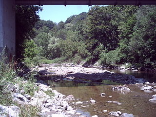
West Hill is a neighbourhood in Toronto, Ontario, Canada. It is located in the eastern end of the city, in the former suburb of Scarborough. It is roughly bounded by Scarborough Golf Club Road and a branch of Highland Creek on the west, the CNR railway tracks and Lake Ontario on the south, and Highland Creek on the north-east. The name comes from its elevated position on the west side of Highland Creek, a deep glacial ravine.

<span class="mw-page-title-main">Scarborough Village</span> Neighbourhood in Toronto, Ontario, Canada

Scarborough Village is a neighbourhood in Toronto, Ontario, Canada, located in the Scarborough district. It was one of the earliest settlements in the former township of Scarborough with the distinction of being the site of the township's first post office. Today, the neighbourhood is composed of private and public housing, apartment complexes, schools, a few condominiums, and strip mall plazas. The neighbourhood lies along the Scarborough Bluffs escarpment.

<span class="mw-page-title-main">Henry Farm</span> Neighbourhood in Toronto, Ontario, Canada

Henry Farm is a neighbourhood in the City of Toronto, Ontario, Canada. It is located in the north central part of the city within the former city of North York.

<span class="mw-page-title-main">Scarborough Bluffs</span> Escarpment in Toronto, Canada

The Scarborough Bluffs, also known as The Bluffs, is an escarpment in the Scarborough district of Toronto, Ontario, Canada. There are nine parks along the bluffs, with Bluffers Park being the only one with a beach. Forming much of the eastern portion of Toronto's waterfront, the Scarborough Bluffs stands above the shoreline of Lake Ontario. At its highest point, the escarpment rises 90 metres (300 ft) above the coastline and spans a length of 15 kilometres (9.3 mi).

<span class="mw-page-title-main">Guildwood GO Station</span> Railway station in Toronto, Ontario, Canada

Guildwood GO Station is a GO Transit train station in Toronto, Ontario, Canada. It is located on Kingston Road in the Guildwood neighbourhood of the district of Scarborough. The station is situated on the CN Kingston Subdivision. It is a stop on the Lakeshore East line and also for intercity Via Rail Corridor services running from Toronto to Ottawa and Montreal.

<span class="mw-page-title-main">Guild Inn</span> Artist colony and hotel in Toronto, Canada

The Guild Inn, or simply The Guild was a historic hotel in the Guildwood neighbourhood of Scarborough, Toronto, Ontario and was once an artists colony. The surrounding Guild Park and Gardens is notable for a sculpture garden consisting of the rescued facades and ruins of various demolished downtown Toronto buildings such as bank buildings, the old Toronto Star building and the Granite Club. The park is situated on the Scarborough Bluffs with views of Lake Ontario. Guild Park remained open and the refurbishment of the Guild Inn into a facility for social events was completed in May 2017.

<span class="mw-page-title-main">York University Heights</span> Neighbourhood in Toronto, Ontario, Canada

York University Heights, also known as Northwood Park, is a neighbourhood in Toronto, Ontario, Canada. It is one of Toronto's northernmost neighbourhoods, located along the northern boundary of Steeles Avenue in the former city of North York. The neighbourhood is so named because it contains the main campus of York University. This area is most popular with immigrants of Italian and Chinese descent who have established communities in the area. It is located between Sheppard Avenue and Steeles Avenue east of Black Creek.

<span class="mw-page-title-main">Victoria Village</span> Neighbourhood in Toronto, Ontario, Canada

For the settlement established by former slaves in Guyana known as Victoria Village see Victoria, Guyana

<span class="mw-page-title-main">Pleasant View, Toronto</span> Neighbourhood in Toronto, Ontario, Canada

Pleasant View is a neighbourhood in the city of Toronto, Ontario, Canada that is located in the district of North York at the northern end of the city. It is bordered by Victoria Park to the East, Sheppard Avenue to the South, Highway 404 to the west and the Finch hydro corridor to the north. The neighbourhood is home to several high-rise apartment and condominium buildings, such as The Clippers.

<span class="mw-page-title-main">Don Valley Village</span> Neighbourhood in Toronto, Ontario, Canada

Don Valley Village is a neighbourhood in the city of Toronto, Ontario, Canada. It is located in the former suburb of North York. Located north of Highway 401 and bisected by Don Mills Road, it is bounded by Sheppard Avenue to the south, Leslie Street to the west, Finch Avenue to the north and Highway 404 to the east. Like the nearby Don River Valley, the neighbourhood has hill and dale topography.

<span class="mw-page-title-main">Sir Wilfrid Laurier Collegiate Institute</span> Public high school in Toronto, Ontario, Canada

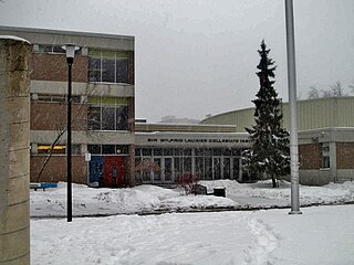
Sir Wilfrid Laurier Collegiate Institute, initially known as Guildwood Secondary School is a high school in Toronto, Ontario, Canada. It is located in the Guildwood neighbourhood in the southern part of the former suburb of Scarborough. It is named in honour of Sir Wilfrid Laurier, the seventh Prime Minister of Canada. The school was established by the Scarborough Board of Education, and is now part of the Toronto District School Board. The motto of the school Hoc Tempus est Tibi which translates into English as "This Time is for You".

<span class="mw-page-title-main">Clairlea</span> Neighbourhood in Toronto, Ontario, Canada

Clairlea is a safe, quiet, middle to upper-middle income neighbourhood in Toronto, Ontario, Canada that features well treed streets and detached homes with large backyards. The neighbourhood is located in east Toronto just east of Victoria Park Avenue.

<span class="mw-page-title-main">Dorset Park</span> Neighbourhood in Toronto, Ontario, Canada

Dorset Park is a neighbourhood in Toronto, Ontario, Canada. It is located in the western part of the district of Scarborough. The neighbourhood is bordered by Highway 401 to the north, Midland Avenue to the east, Lawrence Avenue to the south, and Birchmount Road to the west. Kennedy Road runs along the neighbourhood's centre north and south and Ellesmere Road runs along the centre east and west. The area south of Lawrence Avenue, north of the hydro corridor, is known as McGregor Park and is often included as part of Dorset Park.

<span class="mw-page-title-main">Eglinton East</span> Neighbourhood in Toronto, Ontario, Canada

Eglinton East, historically known as Knob Hill, is a residential and commercial neighbourhood in Toronto, Ontario, Canada. It is bounded by Stansbury Crescent, Citadel Drive, and West Highland Creek to the north, Midland Avenue to the west, the CNR rail line, Brimley Road, and Eglinton Avenue to the south, and Bellamy Road North to the east.

<span class="mw-page-title-main">Morningside Heights, Toronto</span> Neighbourhood in Toronto, Ontario, Canada

Morningside Heights is a residential neighbourhood in Toronto, Ontario, Canada. It is located in the northeast corner of the city, in the district of Scarborough, just north of the neighbourhood of Malvern and west of Rouge Park and the Rouge. The subdivision, comprising approximately 750 acres (3.0 km2), was one of the last large tracts of undeveloped land within the City of Toronto, located between Finch Avenue East and Steeles Avenue East, from Tapscott Road to the Rouge River.

<span class="mw-page-title-main">Osterhout Log Cabin</span> Building

The Osterhout Log Cabin is a log cabin located within Guild Park and Gardens, Guildwood, Scarborough, Toronto, Ontario, Canada. Situated along the Scarborough Bluffs, the cabin is one of the oldest remaining buildings in Scarborough, Toronto.

<span class="mw-page-title-main">Guild Park and Gardens</span> Public park and building stonework conservatory in Toronto, Canada

Guild Park and Gardens is a public park in the Scarborough district of Toronto, Ontario, Canada. The park was formerly the site of an artist colony and is notable for its collection of relics saved from the demolition of buildings primarily in downtown Toronto arranged akin to ancient ruins. Located on the Scarborough Bluffs, Guild Park and Gardens has an outdoor Greek stage and a 19th-century log cabin among the oldest in Toronto. The principal building in the park is the Guild Inn, a former inn and estate mansion.

References

Notes
  1. "The History of Guildwood Village by Bob Taylor-Vaisey". Guildwood Village Community Association. Retrieved 2021-03-31.
  2. "Guildwood - Neighbourhood Census Profile" (PDF).
  3. "Toronto Map - Toronto Neighbourhood Guide". www.torontoneighbourhoods.net. Retrieved 19 April 2018.
  4. "Guildwood Village". Toronto Historical Plaques. Retrieved 8 February 2013.
  5. "Spencer Clark collection". guildwood.on.ca. Archived from the original on 15 February 2009. Retrieved 19 April 2018.
  6. "The Guildwood Village Flag". Guildwood Village Community Association. 2018-07-27. Retrieved 2019-03-18.
  7. Lidgold 2000, p. 322.

43°44′42″N79°11′46″W / 43.745°N 79.196°W / 43.745; -79.196