Harbord Village

Last updated

Harbord Village
Neighbourhood
Formerly 'Doctor's Hospital', on College, 2016 07 21 (1).JPG - panoramio.jpg
View of College Street at the southeastern boundary of Harbord Village
Harbord Village map.PNG
Toronto map.svg
Red pog.svg
Location within Toronto
Coordinates: 43°39′40″N79°24′22″W / 43.661°N 79.406°W / 43.661; -79.406 Coordinates: 43°39′40″N79°24′22″W / 43.661°N 79.406°W / 43.661; -79.406
CountryFlag of Canada (Pantone).svg  Canada
Province Flag of Ontario.svg  Ontario
City Toronto
Government
   MP Chrystia Freeland (University-Rosedale)
   MPP Jessica Bell (University—Rosedale)
   Councillor Dianne Saxe (Ward 11 University—Rosedale)

Harbord Village is a neighbourhood in Toronto, Ontario, Canada. It lies just to the west of the University of Toronto, with its most commonly accepted borders being Bloor Street on the north, Spadina Avenue on the east, College Street to the south, and Bathurst Street to the west. Areas west of Bathurst, as far as Ossington are also sometimes included, though they are not covered by the residents' association. The area was previously known as Sussex-Ulster, after two of the major east west streets in the area. In 2000 the residents' association decided to rename itself and the area Harbord Village, after the main street running through the middle of the community. The street's name origin is unclear but could be named for abolitionist Edward Harbord, 3rd Baron Suffield. [1]

Contents

The area is also sometimes referred to as the South Annex after the better known "Annex" community to the north. The city of Toronto for administrative purposes places Harbord Village and most of the St. George campus into a region it calls "University."

History

The area was primarily opened up for development around 1870, with the initial construction of modest working class houses. Somewhat grander middle class houses began to appear in the late 1880s and 1890s, after a local school had been built and the city had completed paving the streets and installing water and sewer lines. These predominantly Bay and Gable semi-detached houses dominate the current streetscape. Only one block on Brunswick Ave., which was not developed until the 1890s, contains the kind of large houses common to the Annex neighbourhood to the North.

Like most 19th century Torontonians, the initial residents were dominated by immigrants from Great Britain. In the years after the First World War, the neighbourhood gradually became less desirable and more heterogeneous. By the 1930s it had become the home of many immigrants from other parts of the world, including many Eastern European Jews who transformed several of the residences and churches into synagogues (including the First Narayever Congregation which continues to the present day). They, along with the Black residents, faced considerable discrimination renting or buying homes in more affluent Toronto neighbourhoods. As the neighbourhood transitioned into an immigrant reception area, many of the formerly single family houses became shared by two families, and boarders. Subsequent waves of immigration altered the demographics of the area, with many Hungarians arriving following the failed revolution in 1956, and Portuguese in the 1960s and 70s.

Bay-and-gable-styled houses in Harbord Village. The area was initially built up as a working class and lower middle class community in the late-19th century. Harbord Village.JPG
Bay-and-gable-styled houses in Harbord Village. The area was initially built up as a working class and lower middle class community in the late-19th century.

In the late 1960s, partially in conjunction with the planned Spadina Expressway, the city designated the area a slum and planned to demolish and redevelop a large part of it with tall tower blocks as they did with St. James Town. This resulted in the demolition of most of the houses on one block at the Northeast corner of the neighbourhood, and led residents to organize in opposition, forming the Sussex-Ulster Residents' Association. They were successful. Smaller towers were built along Spadina and the rest was given to the University of Toronto to create playing fields and outdoor recreation for their students and the local community. [2] It is currently being redeveloped by the University to serve as an expanded sports field and a public park. [3]

In the 1970s and 80s the neighbourhood was gradually gentrified with an influx of professionals, many affiliated with the university, although many of the houses remained divided into apartments and populated by a diverse mix of people. Since the 1990s many of the houses have been restored to single family dwellings, and because of the heated real estate market, an increasing number are being gutted and rebuilt by developers to sell as luxury properties for several million dollars.

In 2005, the Harbord Village Heritage Conservation District was established in the area of Lower Brunswick Avenue (below Ulster St.) as well as Willcocks Street west of Spadina. In 2009, it was expanded to include Robert Street and Sussex Avenue. The Harbord Village Residents' Association hopes the entire area will become a heritage conservation district.

Lippincott Street runs north-south through Harbord Village, and is an example of the architectural style which used to typify the area. It was originally part of lot 17 purchased in 1815 by George Taylor Denison for the building of his new home "Belle Vue." [4] The street is likely named for Richard Lippincott (Loyalist) who settled in then York. The residential street runs through present day Kensington Market, College Street and Bloor Street. It includes a selection of Toronto architecture, including Victorian worker's cottages, Toronto bay-and-gable and more modern bungalows.

Demographics

Census tracts 0059.00 and 0060.00 of the Canada 2011 Census cover Harbord Village. According to the Statistics Canada 2011, the neighbourhood has 3794 residents, showing a constant decrease in the population. There are various ethnicity based immigrants present in the area, consisting mostly from Europe and East Asia. Out of the selected visible minority, there are 450 Chinese (11.86%), 55 Japanese (1.45%) and 30 Korean (0.79%). [5] Average income is $44,082. The ten most common native languages, after English, are: [5] [6]

  1. Portuguese - 6.35%
  2. Spanish - 5.40%
  3. Cantonese - 4.72%
  4. Italian - 4.55%
  5. Mandarin - 4.20%
  6. German - 2.83%
  7. Hebrew - 2.49%
  8. Korean - 2.32%
  9. Unspecified Chinese - 2.14%
  10. Vietnamese - 1.29%

Harbord Village is a very diverse community. The total population in 2006 of census tract 5350059.00 was 3794. According to the 2006 census, of this population, 90 immigrants were from the United Kingdom, 300 immigrants were from the People's Republic of China, 50 immigrants were from the United States of America, and 20 immigrants that were from the Republic of South Africa. Additionally, the total population in 2011 of census tract 5350059.00 was 3955. According to the 2011 NHS (with reference to GNR: 41.3%), 3955 of this population, there were 55 immigrants that were from the United Kingdom, 220 immigrants that were from China, 105 immigrants that were from the United States, and 0 immigrants that were from the Republic of South Africa.

The Black population increased by 275%, going from 20 to 75 people from 2006 to 2011 respectively. [7] [8] The Latin American population increased by 66.67%, going from 15 to 25 people from 2006 to 2011, while the South Asian population went from 120 to 180 people which is an increase of 50%. [7] [8] The population of those with Chinese origin went from 555 to 450 people, a decrease of 18.92%. [7] [8]

Additionally, 40.8% of the population was 34 years old and younger in 2011, [9] an increase from 28% in the 2006 Census (Statistics Canada, 2006 Census). Amongst those under 34, the age range of 30 to 34 experienced the greatest percentage increase of 65.22% between 2006 and 2011, in comparison to the age range of 25 to 29 which experienced a 65.22% decrease. [10]

(Source: Census 2011, Census 2006, 2011 NHS.)

According to the 2011 NHS, the average income of Tract 0059.00 of residents who are 15-year old and over rose from $36,796 in 2006 to $45,792 in 2011 which is a higher rise than in Ontario or the whole of Canada. The average income of Ontario rose from $38,099 in 2006 to $42,264, and from $35,498 in 2006 to $40,650 in 2011 for the whole of Canada. This sharper rise is largely due to the fact that the segment earning $60,000 and more has virtually doubled between 2006 and 2011 which more than overcame the rise in individuals in the lowest income bracket of $5,000.

Income distribution in this tract is:

% Split by Income Level 2011 2006

Without Income--------- 1.4% 1.6%

Under $5,000--------- 14.7% 12.3%

$5,000 to $9,999--------- 5.5% 11.6%

$10,000 to $14,999------10.4% 13.9%

$15,000 to $19,999------ 9.8% 7.5%

$20,000 to $29,999------ 9.4% 15.2%

$30,000 to $39,999------ 7.7% 8.5%

$40,000 to $49,999------ 6.5% 7.4%

$50,000 to $59,999------ 4.5% 4.4%

$60,000 and over--------30.1% 17.6%

(Source: Census 2011, Census 2006, 2011 NHS.)

Related Research Articles

<span class="mw-page-title-main">Forest Hill, Toronto</span> Neighbourhood in Toronto, Ontario, Canada

Forest Hill is a neighbourhood and former village in Midtown Toronto, Ontario, Canada, located north of Downtown Toronto. The village was amalgamated into Toronto in 1967 and the area has retained its name as a neighbourhood. Along with other neighbourhoods such as Rosedale, and The Bridle Path, it is one of Toronto's wealthiest and most affluent neighbourhoods. It is home to many prominent entrepreneurs, celebrities, engineers, doctors, and lawyers. Census data from Statistics Canada states an average income for all private households in Forest Hill to be $101,631, compared to the $40,704 average income in Toronto's Census Metropolitan Area.

<span class="mw-page-title-main">The Annex</span> Neighbourhood in Toronto, Ontario, Canada

The Annex is a neighbourhood in Downtown Toronto, Ontario, Canada. The traditional boundaries of the neighbourhood are north to Dupont Street, south to Bloor Street, west to Bathurst Street and east to Avenue Road. The City of Toronto recognizes a broader neighbourhood definition that includes the adjacent Seaton Village and Yorkville areas.

<span class="mw-page-title-main">Rosedale, Toronto</span> Neighbourhood in Toronto, Ontario, Canada

Rosedale is a neighbourhood in central Toronto, Ontario, Canada. It was formerly the estate of William Botsford Jarvis, and so named by his wife, granddaughter of William Dummer Powell, for the wild roses that grew there in abundance. It is located north of Downtown Toronto and is one of its oldest suburbs. It is also one of the wealthiest and most highly priced neighbourhoods in Canada. Rosedale has been ranked the best neighbourhood in Toronto to live in by Toronto Life. It is known as the area where the city's 'old money' lives, and is home to some of Canada's richest and most famous citizens including Gerry Schwartz, founder of Onex Corporation, Adrienne Clarkson, the 26th Governor General of Canada, and her husband, the author John Ralston Saul, as well as David Thomson, 3rd Baron Thomson of Fleet of the Thomson Corporation, the latter of whom is the richest man in Canada.

<span class="mw-page-title-main">The Junction</span> Neighbourhood in Toronto, Ontario, Canada

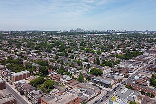
The Junction is a neighbourhood in Toronto, Ontario, Canada, that is near the West Toronto Diamond, a junction of four railway lines in the area. The neighbourhood was previously an independent city called West Toronto, that was also its own federal electoral district until amalgamating with the city of Toronto in 1909. The main intersection of the area is Dundas Street West and Keele Street. The Stockyards is the northeastern quadrant of the neighbourhood.

<span class="mw-page-title-main">Kensington Market</span> Neighbourhood in Toronto, Ontario, Canada

Kensington Market is a distinctive multicultural neighbourhood in Downtown Toronto, Ontario, Canada. The Market is an older neighbourhood and one of the city's most well-known. In November 2006, it was designated a National Historic Site of Canada. Robert Fulford wrote in 1999 that "Kensington today is as much a legend as a district. The (partly) outdoor market has probably been photographed more often than any other site in Toronto."

<span class="mw-page-title-main">Filipino Canadians</span> Ethnic group

Filipino Canadians are Canadians of Filipino descent. Filipino Canadians are the fourth largest subgroup of the overseas Filipinos and one of the fastest-growing groups in Canada.

<span class="mw-page-title-main">Scarborough Village</span> Neighbourhood in Toronto, Ontario, Canada

Scarborough Village is a neighbourhood in Toronto, Ontario, Canada, located in the Scarborough district. It was one of the earliest settlements in the former township of Scarborough with the distinction of being the site of the township's first post office. Today, the neighbourhood is composed of private and public housing, apartment complexes, schools, a few condominiums, and strip mall plazas. The neighbourhood lies along the Scarborough Bluffs escarpment.

<span class="mw-page-title-main">St. James Town</span> Neighbourhood in Toronto, Ontario, Canada

St. James Town is a neighbourhood of Toronto, Ontario, Canada. It lies in the northeast corner of the downtown area. The neighbourhood covers the area bounded by Jarvis Street to the west, Bloor Street East to the north, Parliament Street to the east, and Wellesley Street East to the south.

<span class="mw-page-title-main">Dovercourt Park</span> Neighbourhood in Toronto, Ontario, Canada

Dovercourt Park or Dovercourt Village is a neighbourhood in Toronto, Ontario, Canada situated north of Bloor Street between Christie Street to the east, the CPR railway lines to the north, and Dufferin Street to the west.

<span class="mw-page-title-main">Etobicoke North</span> Federal electoral district in Ontario, Canada

Etobicoke North is a federal electoral district in Toronto, Ontario, Canada, that has been represented by one Member of Parliament in the House of Commons of Canada since 1979. It covers the neighbourhood of Rexdale, in the northern part of the Etobicoke district of Toronto.

The demographics of Toronto, Ontario, Canada make Toronto one of the most multicultural and multiracial cities in the world. In 2021, 57.0 percent of the residents of the metropolitan area belonged to a visible minority group, compared with 51.4 percent in 2016, and 13.6 percent in 1981. Toronto also has established ethnic neighbourhoods such as the multiple Chinatowns, Corso Italia, Little Italy, Little India, Greektown, Koreatown, Little Jamaica, Little Portugal and Roncesvalles, which celebrate the city's multiculturalism. Data from the suburban municipalities are also included for some metrics as most of these municipalities are part of the Toronto CMA.

<span class="mw-page-title-main">Bedford Park, Toronto</span> Neighbourhood in Toronto, Ontario, Canada

Bedford Park is a neighbourhood just outside the downtown core of Toronto. It borders Lawrence Park which was ranked Canada's wealthiest neighbourhood in 2011. The City of Toronto's neighbourhood definitions places most of Bedford Park, including Bedford Park Avenue in the Lawrence Park North Planning Neighbourood and the remaining western and northern portions of Bedford Park within a larger neighbourhood, called Bedford Park-Nortown. The border of this larger area extend to Bathurst Street on the west, Highway 401 to the north, Hillhurst Boulevard to the south, and zigzags from northeast to southwest along Yonge Street and Avenue Road.

<span class="mw-page-title-main">Davisville Village</span> Neighbourhood in Toronto, Ontario, Canada

Davisville Village is a neighbourhood of Toronto, Ontario, Canada. It is located near the intersection of Davisville Avenue and Yonge Street. There is a subway station named Davisville at this intersection. The area directly abuts Mount Pleasant Cemetery, and has many massive apartment and condominium complexes built between the 1970s and the 2000s, as well as a number of office buildings. The area is within Midtown Toronto between St Clair and Eglinton. Davisville Village is represented at Toronto City Council by Councillor Josh Matlow.

<span class="mw-page-title-main">Seaton Village</span> Neighbourhood in Toronto, Ontario, Canada

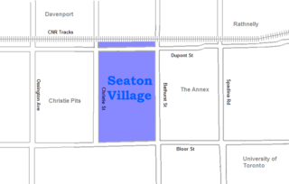
Seaton Village is a neighbourhood and former village located west of Downtown Toronto in Toronto, Ontario, Canada. It is named after John Colborne, 1st Baron Seaton, Lieutenant-Governor of Upper Canada from 1828 to 1836. Seaton Village is bordered by Bloor Street to the south, the Canadian Pacific Railway tracks to the north, Christie Street to the west, and Bathurst Street to the east. Officially, it is an enclave within The Annex neighbourhood, as defined by the City of Toronto. It is sometimes referred to as the West Annex. While Seaton Village shares several characteristics with the Annex, it is often perceived as a quieter, family-oriented neighbourhood with smaller, less expensive homes. The Koreatown shopping district is at its southern border.

<span class="mw-page-title-main">Casa Loma (neighbourhood)</span> Neighbourhood in Toronto, Ontario, Canada

Casa Loma is a neighbourhood in the city of Toronto in Ontario, Canada, and is named after the famous castle. It is bounded on the north by St. Clair Avenue West, on the east by Spadina Road, on the south by the CP railway tracks, and on the west by Bathurst Street. Transit access is provided by the TTC's St. Clair West station and 512 St. Clair streetcar route.

<span class="mw-page-title-main">Alexandra Park, Toronto</span> Neighbourhood in Toronto, Ontario, Canada

Alexandra Park is a neighbourhood located in downtown Toronto, Ontario, Canada. Alexandra Park is bounded by Dundas Street West on the north, Spadina Avenue on the east, Queen Street West on the south, and Bathurst Street on the west. Alexandra Park consists of private and public housing, with at grade retail along Queen Street West and Spadina Avenue, some institutional, and several commercial buildings scattered through the neighborhood. The neighborhood takes its name from Alexandra Park, a municipal park at the south-east corner of Dundas Street West and Bathurst Street. The park is named for Queen Alexandra, wife of King Edward VII, the first future monarch to visit Toronto.

Somali Canadians are Canadians of Somali origin or are dual Somali and Canadian nationality.

<span class="mw-page-title-main">Palmerston-Little Italy</span> Neighbourhood in Toronto, Ontario, Canada

Palmerston-Little Italy is a neighbourhood in central Toronto, Ontario, Canada. Its boundaries, according to the City of Toronto, are by Bathurst Street to the east, Bloor Street to the north, Dovercourt Road to the west and College Street to the south. It is a mature downtown neighbourhood. Within this official neighbourhood of the City of Toronto are two neighbourhoods, Palmerston and Little Italy and the commercial enclave of Mirvish Village.

<span class="mw-page-title-main">Grange Park (neighbourhood)</span> Neighbourhood in Toronto, Ontario, Canada

Grange Park is a neighbourhood in downtown Toronto, Ontario, Canada. It is bounded on the west by Spadina Avenue, on the north by College Street, on the east by University Avenue and on the south by Queen Street West. It is within the 'Kensington-Chinatown' planning neighbourhood of the City of Toronto. Its name is derived from the Grange Park public park. The commercial businesses of Chinatown extend within this neighbourhood.

The demographics of Winnipeg reveal the city to be a typically Canadian one: multicultural and multilingual. Winnipeg is also prominent in the size and ratio of its First Nations population, which plays an important part in the city's makeup. About 12.4% of Winnipeggers are of Indigenous descent, which vastly exceeds the national average of 5.0%.

References

  1. "Harbord's history a mystery".
  2. http://provart.website.snafu.de/UofT/Brief_History_of_Robert_Street_Field_r9.pdf [ bare URL PDF ]
  3. https://www.toronto.ca/legdocs/mmis/2018/cc/bgrd/backgroundfile-118899.pdf [ bare URL PDF ]
  4. "Bellevue". lostrivers.ca. Retrieved 2008-12-17.
  5. 1 2 "NHS Profile, 0059.00, Ontario, 2011". Statistics Canada. 8 May 2013. Retrieved 9 March 2015.
  6. "NHS Profile, 0060.00, Ontario, 2011". Statistics Canada. 8 May 2013. Retrieved 9 March 2015.
  7. 1 2 3 Statistics Canada, 2011 NHS
  8. 1 2 3 Statistics Canada, 2006 Census
  9. Statistics Canada, 2011 Census
  10. Statistics Canada, 2011 and 2006 Census

Further reading