Elmwood, Wisconsin

Last updated

Elmwood, Wisconsin
Pierce County Wisconsin Incorporated and Unincorporated areas Elmwood Highlighted.svg
Location of Elmwood in Pierce County, Wisconsin.
Coordinates: 44°46′44″N92°8′57″W / 44.77889°N 92.14917°W / 44.77889; -92.14917
Country Flag of the United States.svg  United States
State Flag of Wisconsin.svg  Wisconsin
County Pierce
Area
[1]
  Total1.54 sq mi (3.98 km2)
  Land1.51 sq mi (3.92 km2)
  Water0.02 sq mi (0.05 km2)
Elevation
[2]
860 ft (262 m)
Population
 (2010) [3]
  Total817
  Estimate 
(2019) [4]
797
  Density526.07/sq mi (203.11/km2)
Time zone UTC-6 (Central (CST))
  Summer (DST) UTC-5 (CDT)
Area code(s) 715 & 534
FIPS code 55-23700 [5]
GNIS feature ID1564582 [2]
Website http://www.elmwoodwi.org

Elmwood is a village in Pierce County, Wisconsin, along the Eau Galle River. The population was 683 at the 2020 census, [6] down from 817 at the 2010 census.

Contents

History

A post office called Elmwood has been in operation since 1885. [7] The village was named for a grove of elm trees near the town site. [8]

Geography

Elmwood is located at 44°46′44″N92°8′57″W / 44.77889°N 92.14917°W / 44.77889; -92.14917 (44.778996, -92.149090). [9]

According to the United States Census Bureau, the village has a total area of 1.53 square miles (3.96 km2), of which, 1.51 square miles (3.91 km2) of it is land and 0.02 square miles (0.05 km2) is water. [10]

Demographics

Historical population
CensusPop.Note
1910 585
1920 6328.0%
1930 73716.6%
1940 82812.3%
1950 772−6.8%
1960 7760.5%
1970 737−5.0%
1980 88520.1%
1990 775−12.4%
2000 8418.5%
2010 817−2.9%
2019 (est.)797 [4] −2.4%
U.S. Decennial Census [11]

2010 census

As of the census [3] of 2010, there were 817 people, 343 households, and 222 families living in the village. The population density was 541.1 inhabitants per square mile (208.9/km2). There were 379 housing units at an average density of 251.0 per square mile (96.9/km2). The racial makeup of the village was 98.0% White, 0.1% African American, 0.5% Native American, 0.1% Asian, 0.7% from other races, and 0.5% from two or more races. Hispanic or Latino of any race were 3.1% of the population.

There were 343 households, of which 28.6% had children under the age of 18 living with them, 49.9% were married couples living together, 9.3% had a female householder with no husband present, 5.5% had a male householder with no wife present, and 35.3% were non-families. 30.6% of all households were made up of individuals, and 14% had someone living alone who was 65 years of age or older. The average household size was 2.28 and the average family size was 2.82.

The median age in the village was 43.2 years. 22.2% of residents were under the age of 18; 5.5% were between the ages of 18 and 24; 24.8% were from 25 to 44; 26% were from 45 to 64; and 21.7% were 65 years of age or older. The gender makeup of the village was 49.4% male and 50.6% female.

2000 census

As of the census [5] of 2000, there were 841 people, 343 households, and 218 families living in the village. The population density was 568.2 inhabitants per square mile (219.4/km2). There were 366 housing units at an average density of 247.3 per square mile (95.5/km2). The racial makeup of the village was 97.98% White, 0.12% African American, 0.24% Native American, 0.12% Asian, 0.83% from other races, and 0.71% from two or more races. Hispanic or Latino of any race were 1.43% of the population.

There were 343 households, out of which 27.7% had children under the age of 18 living with them, 51.9% were married couples living together, 9.0% had a female householder with no husband present, and 36.4% were non-families. 32.1% of all households were made up of individuals, and 17.8% had someone living alone who was 65 years of age or older. The average household size was 2.29 and the average family size was 2.90.

In the village, the population was spread out, with 22.4% under the age of 18, 6.8% from 18 to 24, 25.4% from 25 to 44, 21.5% from 45 to 64, and 23.9% who were 65 years of age or older. The median age was 41 years. For every 100 females, there were 85.7 males. For every 100 females age 18 and over, there were 80.9 males.

The median income for a household in the village was $33,558, and the median income for a family was $41,250. Males had a median income of $32,375 versus $22,250 for females. The per capita income for the village was $16,369. About 2.3% of families and 4.4% of the population were below the poverty line, including 2.6% of those under age 18 and 8.3% of those age 65 or over.

Education

Elmwood is served by the Elmwood School District, which maintains one school for students in grades K-12. [12] Student organizations include band, choir, student council, Spanish club, forensics, FCCLA, FFA and NHS. Football, volleyball, cross country, dance, boys' basketball, girls' basketball, wrestling, baseball, softball, and track and field are offered at the high school level. The EPC Wolves[ clarification needed ] is the newest addition to the Elmwood Athletics Department. The sports included in this co-op are football, cross country, cheerleading, boys' and girls' basketball, and track and field.

Events

Elmwood hosts an annual "UFO Days" festival on the final weekend of July. Events are held downtown, at the Elmwood Area School athletic fields, and at the Elmwood Rod and Gun Club. Typical events include a parade, a softball tournament, a fun run, a medallion hunt,[ clarification needed ] and live music.

The local interest in UFOs is a result of unexplainable things that have happened around Elmwood. A federal government UFO Working Group investigated Elmwood sightings of unexplained phenomena. [13]

Notable people

Related Research Articles

<span class="mw-page-title-main">Rainbow, California</span> Census designated place in California, United States

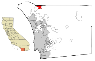
Rainbow is a census designated place (CDP) in northern San Diego County in the U.S. state of California. The population was 1,832 at the 2010 census, down from 2,026 at the 2000 census.

<span class="mw-page-title-main">Otisville, Michigan</span> Village in Michigan, United States

Otisville is a village in Forest Township, Genesee County in the U.S. state of Michigan. The population was 864 at the 2010 census. It is located along M-15, just south of M-57. It is part of the Flint metropolitan area.

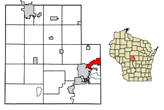
Elmwood Township is a civil township of Tuscola County in the U.S. state of Michigan. The population was 1,060 at the 2020 census.

<span class="mw-page-title-main">Gagetown, Michigan</span> Village in Michigan, United States

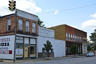
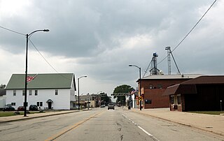
Gagetown is a village in Tuscola County in the U.S. state of Michigan. The population was 388 at the 2010 census. It is located in the northeastern corner of Elmwood Township.

<span class="mw-page-title-main">Wardsville, Missouri</span> Village in Missouri, United States

Wardsville is a village in Cole County, Missouri, United States. The population was 1,599 at the 2020 census. It is part of the Jefferson City, Missouri Metropolitan Statistical Area.

<span class="mw-page-title-main">Elmwood, Nebraska</span> Village in Nebraska, United States

Elmwood is a village in southeast Cass County, Nebraska, United States. The population was 654 at the 2020 census.

<span class="mw-page-title-main">Corona, New Mexico</span> Village in New Mexico, United States

Corona is a village in Lincoln County, New Mexico, United States, located along U.S. Route 54. The population was 172 at the time of the 2010 census.

<span class="mw-page-title-main">Elmwood Place, Ohio</span> Village in Hamilton County, Ohio, United States

Elmwood Place is a village in Hamilton County, Ohio, United States. The population was 2,087 at the 2020 census. Except for a small portion which touches neighboring St. Bernard, Elmwood Place is nearly surrounded by the city of Cincinnati.

<span class="mw-page-title-main">St. Bernard, Ohio</span> Village in Ohio, United States

St. Bernard or Saint Bernard is a village in Hamilton County, Ohio, United States. It is an enclave and suburb of Cincinnati. The population was 4,070 at the 2020 census.

<span class="mw-page-title-main">Prospect, Ohio</span> Village in Ohio, United States

Prospect is a village in Marion County, Ohio, United States. The population was 1,067 at the 2020 census. The village is served by Elgin Local School District.

<span class="mw-page-title-main">Bloomdale, Ohio</span> Village in Ohio, United States

Bloomdale is a village in Wood County, Ohio, United States. The population was 665 at the 2020 census.

<span class="mw-page-title-main">Pleasant Valley, Marion County, West Virginia</span> City in West Virginia, United States

Pleasant Valley is a city in Marion County, West Virginia, United States. The population was 3,506 at the 2020 census.

<span class="mw-page-title-main">Coleman, Wisconsin</span> Village in Wisconsin, United States

Coleman is a village in Marinette County, Wisconsin, United States. The population was 726 at the 2020 census. It is part of the Marinette, WI–MI Micropolitan Statistical Area.

<span class="mw-page-title-main">Centuria, Wisconsin</span> Village in Wisconsin, United States

Centuria is a village in Polk County, Wisconsin, United States. The population was 891 at the 2020 census.

<span class="mw-page-title-main">Elmwood Park, Wisconsin</span> Village in Wisconsin, United States

Elmwood Park is a village in Racine County, Wisconsin, United States. The population was 510 at the 2020 census.

<span class="mw-page-title-main">Troy, Walworth County, Wisconsin</span> Town in Wisconsin, United States

Troy is a town in Walworth County, Wisconsin, United States. The population was 2,355 at the 2020 census. The unincorporated communities of Adams, Little Prairie, and Troy Center are located in the town. The ghost town of Mayhews was also located in the town.

<span class="mw-page-title-main">Biron, Wisconsin</span> Village in Wisconsin, United States

Biron is a village in Wood County, Wisconsin, United States. The population was 839 at the 2010 census. It is the site of ND Paper's Biron Mill.

<span class="mw-page-title-main">Belleville, Wisconsin</span> Village in Wisconsin, United States

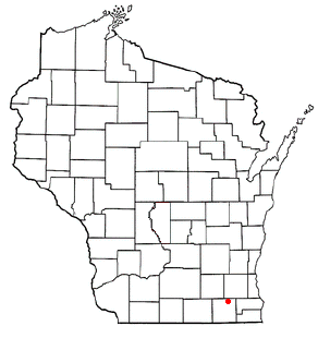
Belleville is a village in Dane and Green counties in the U.S. state of Wisconsin. The population was 2,491 at the 2020 census. Of this, 1,909 were in Dane County, and 582 were in Green County.

<span class="mw-page-title-main">Birnamwood, Wisconsin</span> Village in Wisconsin, United States

Birnamwood is a village in Marathon and Shawano counties in the U.S. state of Wisconsin. It is part of the Wausau, Wisconsin Metropolitan Statistical Area. The population was 818 at the 2010 census. Of this, 802 were in Shawano County, and 16 were in Marathon County. The village is located mostly within the town of Birnamwood in Shawano County; only a small portion extends into the town of Norrie in adjacent Marathon County.

<span class="mw-page-title-main">Unity, Wisconsin</span> Village in Wisconsin, United States

Unity is a village in Clark and Marathon counties in the U.S. state of Wisconsin. It is part of the Wausau, Wisconsin Metropolitan Statistical Area. The population was 343 at the 2010 census. Of this, 204 were in Marathon County, and 139 were in Clark County. The village is located in northeastern town of Unity in Clark County and northwestern town of Brighton in Marathon County.

References

  1. "2019 U.S. Gazetteer Files". United States Census Bureau. Retrieved August 7, 2020.
  2. 1 2 "US Board on Geographic Names". United States Geological Survey. October 25, 2007. Retrieved January 31, 2008.
  3. 1 2 "U.S. Census website". United States Census Bureau . Retrieved November 18, 2012.
  4. 1 2 "Population and Housing Unit Estimates". United States Census Bureau. May 24, 2020. Retrieved May 27, 2020.
  5. 1 2 "U.S. Census website". United States Census Bureau . Retrieved January 31, 2008.
  6. "Census profile: Elmwood, WI". Census Reporter. Retrieved April 30, 2024.
  7. "Pierce County". Jim Forte Postal History. Archived from the original on April 3, 2015. Retrieved March 17, 2015.
  8. Chicago and North Western Railway Company (1908). A History of the Origin of the Place Names Connected with the Chicago & North Western and Chicago, St. Paul, Minneapolis & Omaha Railways. p. 68.
  9. "US Gazetteer files: 2010, 2000, and 1990". United States Census Bureau. February 12, 2011. Retrieved April 23, 2011.
  10. "US Gazetteer files 2010". United States Census Bureau. Archived from the original on January 25, 2012. Retrieved November 18, 2012.
  11. "Census of Population and Housing". Census.gov. Retrieved June 4, 2015.
  12. "Elmwood School District". www.elmwood.k12.wi.us. Retrieved October 15, 2015.
  13. Howard Blum. Out There: The Government's Secret Quest for Extraterrestrials. New York: Simon & Schuster, 1990, pp. 156-201.