Isabelle, Wisconsin

Last updated

Isabelle, Wisconsin
WIMap-doton-Isabelle.png
Location of Isabelle, Wisconsin
Coordinates: 44°35′40″N92°27′3″W / 44.59444°N 92.45083°W / 44.59444; -92.45083
Country Flag of the United States.svg  United States
State Flag of Wisconsin.svg  Wisconsin
County Pierce
Area
  Total15.7 sq mi (40.5 km2)
  Land10.4 sq mi (27.0 km2)
  Water5.2 sq mi (13.6 km2)
Elevation
[1]
679 ft (207 m)
Population
 (2000)
  Total315
  Density30.2/sq mi (11.7/km2)
Time zone UTC-6 (Central (CST))
  Summer (DST) UTC-5 (CDT)
Area code(s) 715 & 534
FIPS code 55-37350 [2]
GNIS feature ID1583438 [1]

Isabelle is a town in Pierce County, Wisconsin, United States. The population was 315 at the 2000 census. The unincorporated community of Oakridge is located in the town.

Contents

Geography

According to the United States Census Bureau, the town has a total area of 15.6 square miles (40.5 km2), of which, 10.4 square miles (27.0 km2) of it is land and 5.2 square miles (13.6 km2) of it (33.48%) is water.

Demographics

As of the census [2] of 2000, there were 315 people, 113 households, and 88 families residing in the town. The population density was 30.2 inhabitants per square mile (11.7/km2). There were 118 housing units at an average density of 11.3 per square mile (4.4/km2). The racial makeup of the town was 99.05% White, 0.32% African American and 0.63% Native American. Hispanic or Latino of any race were 1.59% of the population.

There were 113 households, out of which 42.5% had children under the age of 18 living with them, 61.9% were married couples living together, 9.7% had a female householder with no husband present, and 22.1% were non-families. 15.9% of all households were made up of individuals, and 2.7% had someone living alone who was 65 years of age or older. The average household size was 2.79 and the average family size was 3.06.

In the town, the population was spread out, with 27.3% under the age of 18, 5.1% from 18 to 24, 36.2% from 25 to 44, 24.1% from 45 to 64, and 7.3% who were 65 years of age or older. The median age was 35 years. For every 100 females, there were 115.8 males. For every 100 females age 18 and over, there were 110.1 males.

The median income for a household in the town was $52,188, and the median income for a family was $63,125. Males had a median income of $37,212 versus $26,875 for females. The per capita income for the town was $22,626. None of the families and 2.5% of the population were living below the poverty line, including no under eighteens and none of those over 64.

Related Research Articles

<span class="mw-page-title-main">Hytop, Alabama</span> Town in Alabama, United States

Hytop is a town in Jackson County, Alabama, United States. It incorporated on May 17, 1991. As of the 2010 census, the population of the town was 354, up from 315 in 2000. The Walls of Jericho, a popular hiking area, is located just north of Hytop.

<span class="mw-page-title-main">Clear Lake, Indiana</span> Town in Indiana, United States

Clear Lake is a town located in the northeast corner of Steuben County, Indiana, in Clear Lake Township. As such, is the northeasternmost community in the State of Indiana. The population was 339 at the 2010 census.

<span class="mw-page-title-main">Yetter, Iowa</span> City in Iowa, United States

Yetter is a city in Calhoun County, Iowa, United States. The population was 19 at the time of the 2020 census.

<span class="mw-page-title-main">Libertyville, Iowa</span> City in Iowa, United States

Libertyville is a city in Jefferson County, Iowa, United States. The population was 274 at the time of the 2020 census. It was platted in 1845.

<span class="mw-page-title-main">Bronson, Iowa</span> City in Iowa, United States

Bronson is a city in Woodbury County, Iowa, United States. It is part of the Sioux City metropolitan area. The population was 294 at the 2020 census.

<span class="mw-page-title-main">Upton, Maine</span> Town in the state of Maine, United States

Upton is a town in Oxford County, Maine, United States. The population was 69 at the 2020 census.

Lowell is a town in Penobscot County, Maine, United States. The population was 368 at the 2020 census.

<span class="mw-page-title-main">Hartland, Minnesota</span> City in Minnesota, United States

Hartland is a city in Freeborn County, Minnesota, United States. The population was 315 at the 2010 census.

<span class="mw-page-title-main">Cave, Missouri</span> City in Missouri, United States

Cave is a City in Lincoln County, Missouri, United States. The population was 5 at the 2010 census. However, As of the 2020 census, the population is 0, making it the smallest incorporated community in the U.S state of Missouri. It is the 939th largest city in Missouri and the 19481st largest city in the United States. Cave is currently declining at a rate of 0.00% annually and its population has decreased by 0.00% since the most recent census, which recorded a population of 5 in 2010.

<span class="mw-page-title-main">McDonald, North Carolina</span> Town in North Carolina, United States

McDonald is a town in Robeson County, North Carolina, United States. The population was 113 at the 2010 census.

<span class="mw-page-title-main">Crary, North Dakota</span> City in North Dakota, United States

Crary is a city in Ramsey County, North Dakota, United States. The population was 113 at the 2020 census. Crary was founded in 1884 and is named after William Crary, who owned much of the land encompassing the present day community.

<span class="mw-page-title-main">Mount Tabor, Vermont</span> Town in Vermont, United States

Mount Tabor is a town in Rutland County, Vermont, United States. The population was 210 at the 2020 census.

<span class="mw-page-title-main">Mitchell Heights, West Virginia</span> Town in West Virginia, United States

Mitchell Heights is a town in Logan County, West Virginia, United States. The population was 315 at the 2020 census. The town was named for an early farm on which it was established.

<span class="mw-page-title-main">Montrose, West Virginia</span> Town in West Virginia, United States

Montrose is a town in Randolph County, West Virginia, United States. The population was 141 at the 2020 census.

<span class="mw-page-title-main">Kildare, Wisconsin</span> Town in Wisconsin, United States

Kildare is a town in Juneau County, Wisconsin, United States. The population was 557 at the 2000 census.

<span class="mw-page-title-main">New Lyme, Wisconsin</span> Town in Wisconsin, United States

New Lyme is a town in Monroe County, Wisconsin, United States. The population was 141 at the 2000 census.

<span class="mw-page-title-main">Center, Outagamie County, Wisconsin</span> Town in Wisconsin, United States

The Town of Center is a located in Outagamie County, Wisconsin, United States. The population was 3,622 as of the 2020 census. The unincorporated communities of Center Valley, Hamples Corner, Mackville, and Twelve Corners are located in the town. The unincorporated community of Five Corners is also located partially in the town.

<span class="mw-page-title-main">Spring Lake, Wisconsin</span> Town in Wisconsin, United States

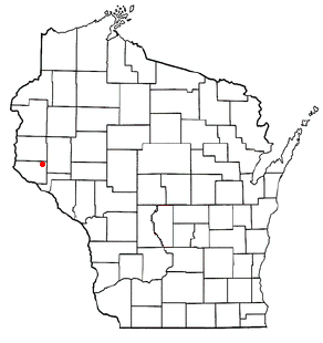
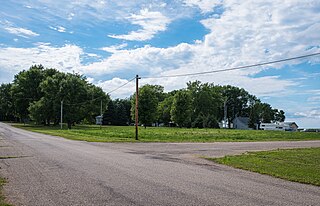
Spring Lake is a town in Pierce County, Wisconsin, in the United States. As of the 2000 census, the town population was 550. The unincorporated communities of Hatchville and Olivet are located partially in the town.

<span class="mw-page-title-main">Richland, Rusk County, Wisconsin</span> Town in Wisconsin, United States

Richland is a town in Rusk County, Wisconsin, United States. The population was 206 at the 2000 census. The village of Ingram is located in the town.

Eden is a town in Fond du Lac County, Wisconsin, United States. The population was 979 at the 2000 census. The Village of Eden is located within the town. The unincorporated community of Marblehead is located also in the town.

References

  1. 1 2 "US Board on Geographic Names". United States Geological Survey. October 25, 2007. Retrieved January 31, 2008.
  2. 1 2 "U.S. Census website". United States Census Bureau . Retrieved January 31, 2008.