Exit numbers in the United States

Last updated

Exit Numbers in the United States by State as of August 2021 US-Exit-Numbers.svg
Exit Numbers in the United States by State as of August 2021

Exit numbers in the United States are assigned to freeway junctions, and are usually numbered as exits from freeways. Exit numbers generally are found above the destinations and route number(s) at the exit, as well as a sign in the gore. Exit numbers typically reset at political borders such as state lines. Some major streets also use exit numbers. Freeway exits in the United States are usually numbered in two formats: distance-based and sequential.

Contents


Interstate Highways

An example of a green exit number plaque for two exits at the same interchange MUTCD E1-5dP.svg
An example of a green exit number plaque for two exits at the same interchange
An example of a green exit number plaque for a left exit with a yellow "left" panel MUTCD E1-5hP.svg
An example of a green exit number plaque for a left exit with a yellow "left" panel
Old mile tabs on I-295 in Rhode Island, several other states did this. As of September 2007
, these signs have been replaced and use only the sequential exit number scheme. Exit numbers on I-295 have since been converted to mile-based numbers. Mile tabs.jpg
Old mile tabs on I-295 in Rhode Island, several other states did this. As of September 2007, these signs have been replaced and use only the sequential exit number scheme. Exit numbers on I-295 have since been converted to mile-based numbers.

The Federal Highway Administration (FHWA) generally requires exit numbers (mile-based or sequential) on the Interstate Highway System; the FHWA established that requirement in 1970. The Manual on Uniform Traffic Control Devices (MUTCD) encouraged use of mileposts and exit numbering by 1961. The MUTCD mandated exit numbering in 1971.[ citation needed ] The FHWA granted California an exception due to the cost of installing and maintaining additional signage; the state was able to obtain a waiver because it had already built most of its freeways, although some freeways in Los Angeles County received junction numbers: Interstate 10 (I-10) was the only freeway in the county that had a complete set of junction numbers. I-5, US Route 101 (US 101), and then State Route 11 (now I-110/SR 110) were numbered for short distances from downtown Los Angeles. Freeway connections were unnumbered, and junction numbers were only shown on plates, not on gore signs. In 2002, the Cal-NExUS program began to completely number California's junctions. [1] The program is not well-funded, especially because of California's budget woes, so exits are only being signed with numbers when signs need to be replaced. As the efficiency of an exit numbering system for navigational purposes depends on all exits being consistently numbered, the usefulness of the system while only some exits are numbered is limited. Originally, the initial completion date for this project was set as November 2004. The deadline was then extended to 2008. However, the 2006 edition of the California Manual on Uniform Traffic Control Devices removed any sort of compliance deadline for the exit numbers.

As of June 2008, nine states—mostly in the Northeast—and the District of Columbia used sequential numbering schemes on at least one highway, although the 2009 edition of the MUTCD requires these jurisdictions to transition to distance-based numbering. Although a ten-year compliance period was proposed for the new edition of the MUTCD, [2] a compliance date for this change was ultimately not adopted with the 2009 edition, meaning that the transition is accomplished through a systematic upgrading of existing signing and there is no specific date by which the change must be implemented. However, the FHWA has required that all federally funded routes with sequential numbering eventually be converted to mileage-based exit numbers. To that end, the FHWA has required each state that currently uses sequential exit numbering to submit a plan to eventually transition to distance-based exit numbers. [3] Some of the states that currently have sequential numbering either have or intend to request a waiver from the Federal Highway Administration to retain their current numbering systems, while others have planned a gradual transition to mileage-based exit numbering over time as existing signage reaches the end of its serviceable life and is replaced.

The mile-based requirement mandates multiple exits in the same mile to use a letter suffix in alphabetical order. This also applies to divided interchanges, where two exits are used for opposite directions of the road, for example on full cloverleaf interchanges. Older exit numbering schemes sometimes use cardinal directions (E, N, S, W, often E-W or N-S) depending on the directionality of the cross route(s), for example I-93 in New Hampshire uses exits 15E and 15W for the cloverleaf interchange with US 202 in Concord which is signed east and west at the interchange. Many exits in the Northeastern states which currently or formerly used sequential numbering schemes had these directional abbreviations, but most have converted to A-B schemes. (As of 2019, New Hampshire is the only state to have never used distance-based exits, including experimental dual exit/mile numbers/letters.)

The New Jersey Turnpike mainline splits into an Eastern Spur and Western Spur between interchanges 15 and 18. Because of this, E and W suffixes are present on these spurs (15E-16E-18E and 15W-16W-18W) to differentiate the interchange and roadway. One interchange on the Eastern Spur was constructed at a later time between 15E and 16E, creating an exit 15X. The letter X was used to represent access to the Secaucus Junction rail station (in the planning stages as Secaucus Transfer, or Xfer), and to avoid an Interchange 15EA designation.

An example of sequentially-numbered exits in Connecticut on the Charter Oak Bridge, Route 15/US 5; the state has begun the federally mandated conversion to mile-based exits. Charter Oak Bridge Highway Signs.jpg
An example of sequentially-numbered exits in Connecticut on the Charter Oak Bridge, Route 15/US 5; the state has begun the federally mandated conversion to mile-based exits.

Several states still maintain systems other than the MUTCD-standard mileage based systems, among these are:

Two highways (I-19 in Arizona and Delaware Route 1 [DE 1]) have metric numbering, because they were constructed during the time when the US was thought to be completely converting to metric. DE 1 has used standard mileposts since 2003 when the metric-based posts were replaced, and several exit numbers (79, 83, 86, 88, 119) do not coincide with either the milemarker nor its kilometer conversion as they are offset by miles from a kilometer-based exit. I-19 currently has all exit numbers and distances in kilometers, but speed limits in miles per hour. The road has received funding for the distances to be changed back to miles, but in response to local opposition against exit number changes, the Arizona Department of Transportation had decided to spend the money on other roads instead. [8]

Other highways

Exit numbering on non-Interstate highways is less consistent. For example, Texas, which normally uses mile-based exit numbering, uses sequential numbering on US 75 between downtown Dallas and the Oklahoma border. Similarly, the US 54 freeway from El Paso to the New Mexico state line also uses sequential exit numbering.

States that renumbered exits

Many states formerly used sequential numbers, and in some cases used exit numbers sparingly, if at all. The following states have introduced mile-based exit numbering on some or all of their highways:

Early exit numbers

Related Research Articles

<span class="mw-page-title-main">Interstate Highway System</span> Network of freeways in the United States

The Dwight D. Eisenhower National System of Interstate and Defense Highways, commonly known as the Interstate Highway System, or the Eisenhower Interstate System, is a network of controlled-access highways that forms part of the National Highway System in the United States. The system extends throughout the contiguous United States and has routes in Hawaii, Alaska, and Puerto Rico.

<span class="mw-page-title-main">Exit number</span> Number assigned to a road junction

An exit number is a number assigned to a road junction, usually an exit from a freeway. It is usually marked on the same sign as the destinations of the exit. In some countries, such as the United States, it is also marked on a sign in the gore.

<span class="mw-page-title-main">Interstate 215 (California)</span> Interstate highway in California

Interstate 215 (I-215) is a 54.5-mile-long (87.7 km) north–south auxiliary Interstate Highway in the Inland Empire region of the San Bernardino–Riverside urban area in Southern California. It has portions designated as the Barstow, Escondido, and Armed Forces Freeways. I-215 is a bypass auxiliary route of I-15, running from Murrieta to northern San Bernardino. While I-215 connects the city centers of both Riverside and San Bernardino, its parent I-15 runs to the west through Corona and Ontario.

Stone Mountain Freeway is a freeway in the north-central part of the U.S. state of Georgia. It connects Interstate 285 (I-285) east of Atlanta, with the suburbs of Stone Mountain and Snellville before transitioning into an arterial road that continues to Athens. The freeway is signed as U.S. Route 78 (US 78) for its entire length, with the western half signed as State Route 410 (SR 410), and the eastern half also being signed as SR 10. It begins at the US 29/US 78 split northeast of Decatur, and continues east through eastern DeKalb and southern Gwinnett counties. The portion of Stone Mountain Freeway from I-285 to the Dekalb/Gwinnett county line is alternatively designated as Bill Evans Highway.

<span class="mw-page-title-main">Interstate 376</span> Highway in Pennsylvania

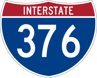
Interstate 376 (I-376) is a major auxiliary route of the Interstate Highway System in the US state of Pennsylvania, located within the Allegheny Plateau. It runs from I-80 near Sharon south and east to a junction with the Pennsylvania Turnpike in Monroeville, after having crossed the Pennsylvania Turnpike at an interchange in Big Beaver. The route serves Pittsburgh and its surrounding areas and is the main access road to Pittsburgh International Airport (PIT). Portions of the route are known as the Beaver Valley Expressway, Southern Expressway, and Airport Parkway. Within Allegheny County, the route runs along the majority of the Penn-Lincoln Parkway, known locally as Parkway West and Parkway East. It is currently the ninth-longest auxiliary Interstate route in the system and second only to I-476 within Pennsylvania.

<span class="mw-page-title-main">Interstate 595 (Florida)</span> Interstate highway in Broward County, Florida

Interstate 595 (I-595), also known as the Port Everglades Expressway and unsigned FloridaState Road 862, is a 12.86-mile (20.70 km) auxiliary Interstate Highway that connects I-75 and Alligator Alley in the west with Florida's Turnpike, I-95, Fort Lauderdale–Hollywood International Airport, U.S. Highway 1, and SR A1A before terminating at Port Everglades in the east. The Interstate route was conceived in 1969 and planned as an Interstate starting in 1974. Construction began in 1984, with the expressway opening in stages in the late 1980s, with completion in 1991. The reversible tolled express lanes opened in 2014.

<span class="mw-page-title-main">Concurrency (road)</span> Road bearing more than one route number

A concurrency in a road network is an instance of one physical roadway bearing two or more different route numbers. When two roadways share the same right-of-way, it is sometimes called a common section or commons. Other terminology for a concurrency includes overlap, coincidence, duplex, triplex, multiplex, dual routing or triple routing.

<span class="mw-page-title-main">Interstate 195 (New Jersey)</span> Highway in New Jersey

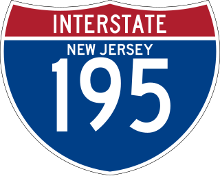
Interstate 195 (I-195) is an auxiliary route of the Interstate Highway System located in the US state of New Jersey. Its western end is at I-295 and Route 29 just south of Trenton in Hamilton Township, Mercer County, while its eastern end is at the Garden State Parkway, Route 138, and Route 34 in Wall Township, Monmouth County. I-195 is 34.17 miles (54.99 km) in length. The route is mostly a four-lane highway that mainly runs through agrarian and wooded areas in Central Jersey. It has an interchange with the New Jersey Turnpike (I-95) in Robbinsville Township and serves as a main access road to New Jersey's state capital of Trenton, the Horse Park of New Jersey, the Six Flags Great Adventure amusement park, and the Jersey Shore. I-195 is occasionally referred to as the Central Jersey Expressway. On April 6, 1988, President Ronald Reagan signed H.R. 4263 naming I-195 in New Jersey the James J. Howard Interstate Highway, in honor of the late James J. Howard.

<span class="mw-page-title-main">Interstate 84 (Pennsylvania–Massachusetts)</span> Interstate Highway in the U.S. states of Pennsylvania, New York, Connecticut, and Massachusetts

Interstate 84 (I-84) is an Interstate Highway in the Northeastern United States that extends from Dunmore, Pennsylvania, near Scranton at an interchange with I-81 east to Sturbridge, Massachusetts, at an interchange with the Massachusetts Turnpike (I-90). Among the major cities that the road passes through is Hartford, Connecticut, and the road provides a major portion of the primary route between New York City and Boston. Another highway named I-84 is located in the Northwestern United States.

<span class="mw-page-title-main">Interstate 76 (Ohio–New Jersey)</span> Interstate from Ohio to New Jersey

Interstate 76 (I-76) is an east–west Interstate Highway in the Eastern United States. The highway runs approximately 435.66 miles (701.13 km) from an interchange with I-71 west of Akron, Ohio, east to I-295 in Bellmawr, New Jersey. This route is not contiguous with I-76 in Colorado and Nebraska.

<span class="mw-page-title-main">Interstate 395 (Connecticut–Massachusetts)</span> Highway in Connecticut and Massachusetts

Interstate 395 (I-395) is an auxiliary Interstate Highway in the U.S. states of Connecticut and Massachusetts; it is maintained by the Connecticut Department of Transportation (CTDOT) and the Massachusetts Department of Transportation (MassDOT). Spanning nearly 67 miles (108 km) on a south–north axis, it is the only spur route of I-95 in Connecticut. The 36-mile (58 km) section between its splits from I-95 in East Lyme and Connecticut Route 695 in Plainfield is a component highway of the Connecticut Turnpike. Within that state, the highway is named the American Ex-Prisoner of War Memorial Highway from Plainfield to Thompson.

<span class="mw-page-title-main">Interstate 290 (Massachusetts)</span> Interstate Highway in Massachusetts, United States

Interstate 290 (I-290) is an auxiliary Interstate Highway in the US state of Massachusetts, maintained by the Massachusetts Department of Transportation (MassDOT). Spanning approximately 20 miles (32 km), it is signed as an east–west spur route of I-90 in Central Massachusetts. The route begins in Auburn at I-90 as a northward continuation of I-395. It follows an L-shaped route, the nominally western half of which runs north into the city of Worcester, and, upon leaving the city, turns to the east to its eastern terminus at I-495 in Marlborough. Past I-495, the road continues as an unnumbered one-mile (1.6 km) connector to the town of Hudson. The route serves as the main freeway route through Worcester, as well as being part of a longer distance travel corridor through New England, connecting Connecticut and Western Massachusetts with much of New Hampshire and Maine.

<span class="mw-page-title-main">Interstate 540 (North Carolina)</span> State highway and Interstate Highway in North Carolina, US

Interstate 540 (I-540) and North Carolina Highway 540 (NC 540) are part of a partially completed beltway around the city of Raleigh in the US state of North Carolina, forming the Raleigh Outer Loop. When complete, the route will completely encircle the city, meeting its parent route of I-40 in two locations.

The Massachusetts State Highway System in the U.S. Commonwealth of Massachusetts is a system of state-numbered routes assigned and marked by the highway division of the Massachusetts Department of Transportation (MassDOT). U.S. Highways and Interstate Highways are included in the system; the only overlaps are with the end-to-end U.S. Route 3 and Route 3 and the far-apart Interstate 295, shared with Rhode Island, and Route 295, shared with New York State. A state highway in Massachusetts is a road maintained by the state, which may or may not have a number. Not all numbered routes are maintained or owned by the state.

<span class="mw-page-title-main">New Hampshire Highway System</span>

The New Hampshire Highway System is the public roads system of the U.S. state of New Hampshire containing approximately 17,029 miles (27,406 km) maintained by the New Hampshire Department of Transportation (NHDOT). All public roads in the state are called "highways", thus there is no technical distinction between a "road" or a "highway" in New Hampshire.

<span class="mw-page-title-main">Connecticut Route 8</span> Highway in Connecticut

Route 8 is a 67.36-mile (108.41 km) state highway in Connecticut that runs north–south from Bridgeport, through Waterbury, all the way to the Massachusetts state line where it continues as Massachusetts Route 8. Most of the highway is a four-lane freeway but the northernmost 8.8 miles (14.2 km) is a two-lane surface road.

<span class="mw-page-title-main">Connecticut Route 2</span> State highway in Hartford and New London counties in Connecticut, United States

Route 2 is a 58.03-mile (93.39 km) state highway in Hartford and New London counties in Connecticut. It is a primary state route, with a freeway section connecting Hartford to Norwich and following surface roads to Stonington. The entire freeway section of Route 2 is also known as the Veterans of Foreign Wars Memorial Highway Though it is labelled an east-west highway, it follows a northwest-southeast route, with large sections of the highway running north-south throughout its duration.

<span class="mw-page-title-main">Interstate 95 in New York</span> Highway in New York

Interstate 95 (I-95) is part of the Interstate Highway System and runs from Miami, Florida, to the Canada–United States border near Houlton, Maine. In the US state of New York, I-95 extends 23.50 miles (37.82 km) from the George Washington Bridge in New York City to the Connecticut state line at Port Chester. The George Washington Bridge carries I-95 across the Hudson River from New Jersey into New York City. There, I-95 runs across Upper Manhattan on the Trans-Manhattan Expressway for 0.81 miles (1.30 km) through Washington Heights. It continues east across the Harlem River on the Alexander Hamilton Bridge and onto the Cross Bronx Expressway. In the Bronx, I-95 leaves the Cross Bronx at the Bruckner Interchange, joining the Bruckner Expressway to its end. North of the interchange with Pelham Parkway, it then continues northeast via the New England Thruway out of New York City into Westchester County and to the Connecticut state line, where I-95 continues on the Connecticut Turnpike.

<span class="mw-page-title-main">Interstate 95 in Connecticut</span> Highway in Connecticut

Interstate 95 (I-95) is the main north–south Interstate Highway on the East Coast of the United States, running in a general east–west compass direction for 111.57 miles (179.55 km) in Connecticut, from the New York state line to the Rhode Island state line. I-95 from Greenwich to East Lyme is part of the Connecticut Turnpike, during which it passes through the major cities of Stamford, Bridgeport, and New Haven. After leaving the turnpike in East Lyme, I-95 is known as the Jewish War Veterans Memorial Highway and passes through New London, Groton, and Mystic, before exiting the state through North Stonington at the Rhode Island border.

<span class="mw-page-title-main">Interstate 75 in Florida</span> Highway in Florida

Interstate 75 (I-75) is a part of the Interstate Highway System that runs from the Hialeah–Miami Lakes border, a few miles northwest of Miami, to Sault Ste. Marie in the Upper Peninsula of Michigan. I-75 begins its national northward journey near Miami, running along the western parts of the Miami metropolitan area before traveling westward across Alligator Alley, resuming its northward direction in Naples, running along Florida's Gulf Coast, and passing the cities of Fort Myers, Punta Gorda, Venice, and Sarasota. The freeway passes through the Tampa Bay area before turning inward toward Ocala, Gainesville, and Lake City before leaving the state and entering Georgia. I-75 runs for 471 miles (758 km) in Florida, making it the longest Interstate in the state and also the longest in any state east of the Mississippi River. The Interstate's speed limit is 70 mph (110 km/h) for its entire length in Florida.

References

  1. Brown, Patricia Leigh (February 10, 2002). "Counting the way to San Jose". The New York Times . p. WK2.
  2. "Proposed Amendments to the MUTCD". § 2E.27 ll. 33–41.
  3. "Introduction". Manual on Uniform Traffic Control Devices (2009 ed.). ¶¶ 22–24, Table I-2.
  4. "I-395 Exit Re-Numbering Will Create Problems". Montville, CT Patch. May 17, 2013.
  5. https://www.mass.gov/info-details/statewide-exit-renumbering-project-details [ bare URL ]
  6. "Upstate New York Roads: Interstate 890 Interchange Guide". Archived from the original on May 21, 2011. Retrieved June 22, 2007.[ self-published source ]
  7. "New interstate exit numbering system in Vermont? Scott hopes not". VTDigger. July 20, 2018.
  8. Holley, Denise (March 17, 2009). "New signs on Interstate 19 courtesy of recovery funds". Nogales International . Retrieved December 29, 2009.
  9. "Florida Department of Transportation Interchange Report" (PDF). Florida Department of Transportation. November 24, 2008. Archived from the original (PDF) on February 8, 2012. Retrieved July 27, 2009.
  10. "Taconic State Parkway to get exit numbers". The Journal News.
  11. "Highway Reference (SR-154)". Utah Department of Transportation. September 10, 2018. Retrieved August 11, 2019.
  12. "Highway Reference (SR-201)". Utah Department of Transportation. August 16, 2018. Retrieved August 11, 2019.
  13. "Highway Reference (US-89)". Utah Department of Transportation. May 14, 2019. Retrieved August 11, 2019.
  14. Wisconsin Department of Transportation. "Exit Numbers on Wisconsin's Freeways". Archived from the original on October 10, 2007. Retrieved December 6, 2007.
  15. Lozier, Marcia (January 3, 2014). "Caltrans tests reflective sheeting for guide-sign visibility and cost savings". Roads & Bridges . Retrieved October 8, 2015.
  16. "Caltrans working to replace catwalk freeway signs in L.A. to deter vandals, create safer driving". ABC 7 Los Angeles . Retrieved January 5, 2024.
  17. "DOT to Begin Changing Exit Numbers on Route 9, Other CT Roadways Today". December 7, 2020.
  18. "Highway Signs and Sign Supports on Interstate 91 from North Haven to Meriden and on Route 40". Connecticut Department of Transportation.
  19. "E-mail from CONNDOT discussion exit renumbering plans, Oct 21, 2018". Archived from the original on November 6, 2018. Retrieved October 26, 2018.
  20. "Operations: Florida's Interstate Exit Numbers".
  21. "Interstate Exit Numbers". Georgia Department of Transportation. Archived from the original on August 11, 2009.
  22. "These are the new highway exit numbers coming to Massachusetts". www.boston.com.
  23. "2018-11-29".[ full citation needed ]
  24. Exit signs change to mileage-based system along the Hutchinson River Parkway, Rockland/Westchester Journal News, July 30, 2021
  25. "I-475 Exits To Conform To Mileposts". The Blade . Toledo, Ohio. August 7, 1973. p. 17 via Google News Archive.
  26. "Turnpike interchange numbers start changing after Labor Day". The Bryan Times . May 28, 2002. p. 10 via Google News Archive.
  27. "Turnpike signs will be changing". The Bryan Times. September 14, 2002. p. 7 via Google News Archive.
  28. Decker, Marin (July 10, 2005). "I-15 exit sign changes toss a curve at motorists". Deseret News . Retrieved November 23, 2018.
  29. Leighton, Matt (December 12, 2019). "Changes coming to Vermont highway exit signs". WPTZ.

Further reading