Forest Hills, Michigan

Last updated

Forest Hills, Michigan
Ada MI GrandRiver DSCN9684.JPG
The Grand River passing through Forest Hills
Forest Hills, MI location.png
Location within Kent County
USA Michigan location map.svg
Red pog.svg
Forest Hills
Location within the state of Michigan
Usa edcp location map.svg
Red pog.svg
Forest Hills
Location within the United States
Coordinates: 42°56′54″N85°29′32″W / 42.94833°N 85.49222°W / 42.94833; -85.49222
CountryUnited States
State Michigan
County Kent
Townships Ada and Cascade
Area
[1]
  Total50.80 sq mi (131.58 km2)
  Land49.30 sq mi (127.68 km2)
  Water1.51 sq mi (3.90 km2)
Elevation
630 ft (192 m)
Population
 (2020)
  Total28,573
  Density579.60/sq mi (223.78/km2)
Time zone UTC-5 (Eastern (EST))
  Summer (DST) UTC-4 (EDT)
ZIP code(s)
49301 (Ada)
49331 (Lowell)
49525 (Grand Rapids)
49546 (Grand Rapids)
Area code 616
FIPS code 26-29580 [2]
GNIS feature ID1867318 [3]

Forest Hills is an unincorporated community and census-designated place (CDP) in Kent County in the U.S. state of Michigan. The population was 28,573 at the 2020 census, making it the most populous CDP in Michigan. It is also the largest CDP by area in the state of Michigan, encompassing nearly all of Ada Township and most of the northern half of Cascade Township. The Forest Hills Public Schools District serves most of the community. [4]

Contents

Geography

According to the U.S. Census Bureau, the CDP has a total area of 50.80 square miles (131.57 km2), of which 49.27 square miles (127.61 km2) are land and 1.53 square miles (3.96 km2) (3.01%) is water. [5]

The Grand River crosses the community from the east side to the northwest corner.

Major highways

Demographics

Historical population
CensusPop.Note
2010 20,942
2020 28,57336.4%
U.S. Decennial Census [6]

2020 census

As of the 2020 United States census [7] , the area had a population of 28,573 people. The racial makeup was 87.5% Non-Hispanic White, 1.0% Black or African American, 4.3% Asian, 0.1% Native American, and 4.4% from two or more races. Hispanic or Latino people of any race were 4.3% of the population.

2000 census

As of the census [2] of 2000, there were 20,942 people, 7,105 households, and 6,046 families residing in the community. The population density was 424.0 inhabitants per square mile (163.7/km2). There were 7,371 housing units at an average density of 149.3 per square mile (57.6/km2). The racial makeup of the community was 95.28% White, 0.64% African American, 0.20% Native American, 2.63% Asian, 0.34% from other races, and 0.91% from two or more races. Hispanic or Latino of any race were 0.95% of the population.

There were 7,105 households, out of which 44.2% had children under the age of 18 living with them, 78.6% were married couples living together, 4.8% had a female householder with no husband present, and 14.9% were non-families. 12.7% of all households were made up of individuals, and 4.9% had someone living alone who was 65 years of age or older. The average household size was 2.94 and the average family size was 3.23.

In the community, the population was spread out, with 31.4% under the age of 18, 4.9% from 18 to 24, 25.6% from 25 to 44, 29.4% from 45 to 64, and 8.8% who were 65 years of age or older. The median age was 39 years. For every 100 females, there were 99.3 males. For every 100 females age 18 and over, there were 96.1 males.

The median income for a household in the community was $96,150 (2007 estimate [8] ), and the median income for a family was $106,521. Males had a median income of $68,003 versus $37,553 for females. The per capita income for the community was $39,517. About 1.3% of families and 2.0% of the population were below the poverty line, including 1.7% of those under age 18 and 3.9% of those age 65 or over.

Related Research Articles

<span class="mw-page-title-main">North Auburn, California</span> Census-designated place in California, United States

North Auburn is a census-designated place (CDP) in Placer County, California, United States. It is part of the Sacramento–Arden-Arcade–Roseville Metropolitan Statistical Area. The population was 13,452 at the 2020 census.

<span class="mw-page-title-main">Big River, California</span> Census-designated place in California, United States

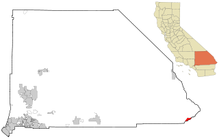
Big River is a census-designated place (CDP) in San Bernardino County, California, United States. The population was 1,084 at the 2020 census, down from 1,327 at the 2010 census.

<span class="mw-page-title-main">Channel Lake, Illinois</span> Census-designated place in Illinois, United States

Channel Lake is an unincorporated community and census-designated place (CDP) in Antioch Township, Lake County, Illinois, United States. Per the 2020 census, the population was 1,581.

<span class="mw-page-title-main">Lake Michigan Beach, Michigan</span> Census-designated place & unincorporated community in Michigan, United States

Lake Michigan Beach is an unincorporated community in Berrien County in the U.S. state of Michigan. It is a census-designated place (CDP) for statistical purposes, without any legal status as a municipality. The population was 1,101 at the 2020 census.

<span class="mw-page-title-main">Waverly, Michigan</span> Census-designated place & unincorporated community in Michigan, United States

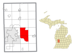
Waverly is an unincorporated community in Eaton County in the U.S. state of Michigan. It is a census-designated place (CDP) for statistical purposes and has no legal status as a municipality. The population was 23,925 at the 2010 census, up from 16,194 at the 2000 census. Waverly is home to the Lansing Mall and Waverly Community Schools.

Au Sable is an unincorporated community and census-designated place (CDP) in Iosco County, Michigan. The population of the CDP was 1,453 at the 2020 census. The community is located within Au Sable Township at the mouth of the Au Sable River along Lake Huron.

<span class="mw-page-title-main">Vandercook Lake, Michigan</span> Census-designated place & unincorporated community in Michigan, United States

Vandercook Lake is an unincorporated community and census-designated place (CDP) in Jackson County in the U.S. state of Michigan. The population of the CDP was 4,721 at the 2010 census. It is located within Summit Township.

<span class="mw-page-title-main">Cutlerville, Michigan</span> Census-designated place & unincorporated community in Michigan, United States

Cutlerville is an unincorporated community and census-designated place (CDP) in Kent County in the U.S. state of Michigan. The population was 17,849 as of the 2020 census. The community is located mostly within Byron Township to the west with a smaller portion within Gaines Township to the east.

<span class="mw-page-title-main">Northview, Michigan</span> Census-designated place & unincorporated community in Michigan, United States

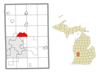
Northview is an unincorporated community and census-designated place (CDP) in Kent County in the U.S. state of Michigan. The population was 14,541 at the 2010 census. The community is located mostly within Plainfield Township with a very small portion extending into Grand Rapids Township to the south.

<span class="mw-page-title-main">West Ishpeming, Michigan</span> Census-designated place & unincorporated community in Michigan, United States

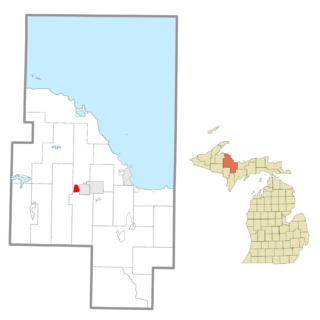
West Ishpeming is an unincorporated community and census-designated place (CDP) in Marquette County in the U.S. state of Michigan. The population was 2,552 at the 2020 census. The community is located mostly within Ishpeming Township with a small portion extending south into Tilden Township.

<span class="mw-page-title-main">Detroit Beach, Michigan</span> Census-designated place in Michigan, United States

Detroit Beach is an unincorporated community and census-designated place (CDP) in Monroe County in the U.S. state of Michigan. The population was 1,957 at the 2020 census. The CDP is located within Frenchtown Charter Township, and as an unincorporated community, Detroit Beach has no legal autonomy of its own.

<span class="mw-page-title-main">West Monroe, Michigan</span> Census-designated place & unincorporated community in Michigan, United States

West Monroe is an unincorporated community and census-designated place (CDP) in Monroe County in the U.S. state of Michigan. The population was 3,227 at the 2020 census. The CDP is located within Monroe Charter Township.

<span class="mw-page-title-main">Denton Township, Michigan</span> Civil township in Michigan, United States

Denton Township is a civil township of Roscommon County in the U.S. state of Michigan. The population was 5,293 at the 2020 census.

<span class="mw-page-title-main">Society Hill, Middlesex County, New Jersey</span> Populated place in Middlesex County, New Jersey, US

Society Hill is an unincorporated community and census-designated place (CDP) located within Piscataway Township, in Middlesex County, in the U.S. state of New Jersey. As of the 2010 United States Census, the CDP's population was 3,829.

<span class="mw-page-title-main">Fairview, Monmouth County, New Jersey</span> Populated place in Monmouth County, New Jersey, US

Fairview is an unincorporated community and census-designated place (CDP) located within Middletown Township, in Monmouth County, in the U.S. state of New Jersey. As of the 2010 United States Census, the CDP's population was 3,806.

<span class="mw-page-title-main">Dillonvale, Hamilton County, Ohio</span> Census-designated place in Ohio, United States

Dillonvale is a census-designated place (CDP) in Sycamore Township, Hamilton County, Ohio, United States. The population was 3,436 at the 2020 census.

<span class="mw-page-title-main">East Gaffney, South Carolina</span> Census-designated place in South Carolina, United States

East Gaffney is a census-designated place (CDP) in Cherokee County, South Carolina, United States. The population was 3,085 at the 2010 United States Census.

<span class="mw-page-title-main">Whitmore Lake, Michigan</span> Census-designated place & unincorporated community in Michigan, United States

Whitmore Lake is a census-designated place (CDP) and unincorporated community in the U.S. state of Michigan. The community spans the boundary between Green Oak Township in Livingston County and Northfield Township in Washtenaw County. The population of the CDP was 7,584 at the 2020 census.

<span class="mw-page-title-main">Loveland Park, Ohio</span> Census-designated place in Ohio, United States

Loveland Park is a census-designated place (CDP) located in Symmes Township, Hamilton County and Deerfield Township, Warren County, in the southwestern part of the U.S. state of Ohio. The CDP is named after the city of Loveland. The population was 1,737 at the 2020 census.

<span class="mw-page-title-main">Bedford (CDP), New York</span> Census-designated place in New York, United States

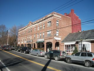
Bedford is a hamlet and census-designated place (CDP) located in the town of Bedford in Westchester County, New York, United States. The population was 1,834 at the 2010 census.

References

  1. "2020 U.S. Gazetteer Files". United States Census Bureau. Retrieved May 21, 2022.
  2. 1 2 "U.S. Census website". United States Census Bureau . Retrieved January 31, 2008.
  3. "US Board on Geographic Names". United States Geological Survey. October 25, 2007. Retrieved January 31, 2008.
  4. Michigan Geographic Framework (November 15, 2013). "Kent County School Districts" (PDF). Archived (PDF) from the original on August 20, 2014. Retrieved April 28, 2021.
  5. "Michigan: 2010 Population and Housing Unit Counts 2010 Census of Population and Housing" (PDF). 2010 United States Census . United States Census Bureau. September 2012. pp. 27–28 Michigan. Archived (PDF) from the original on October 19, 2012. Retrieved October 1, 2021.
  6. "Census of Population and Housing". Census.gov. Retrieved June 4, 2016.
  7. "U.S. Census website". United States Census Bureau . Retrieved May 9, 2024.
  8. 2005–2007 American Community Survey 3-Year Estimates, United States Census Bureau