Northview, Michigan

Last updated

Northview, Michigan
Northview, MI location.png
Location within Kent County
USA Michigan location map.svg
Red pog.svg
Northview
Location within the state of Michigan
Usa edcp location map.svg
Red pog.svg
Northview
Location within the United States
Coordinates: 43°02′20″N85°36′48″W / 43.03889°N 85.61333°W / 43.03889; -85.61333
CountryUnited States
State Michigan
County Kent
Townships Grand Rapids and Plainfield
Area
[1]
  Total11.01 sq mi (28.52 km2)
  Land10.30 sq mi (26.67 km2)
  Water0.72 sq mi (1.85 km2)
Elevation
741 ft (226 m)
Population
 (2020)
  Total15,301
  Density1,486.11/sq mi (573.78/km2)
Time zone UTC-5 (Eastern (EST))
  Summer (DST) UTC-4 (EDT)
ZIP code(s)
49306 (Belmont)
49525 (Grand Rapids)
Area code 616
FIPS code 26-58945 [2]
GNIS feature ID1867321 [3]

Northview is an unincorporated community and census-designated place (CDP) in Kent County in the U.S. state of Michigan. The population was 14,541 at the 2010 census. The community is located mostly within Plainfield Township with a very small portion extending into Grand Rapids Township to the south. [4]

Contents

The community is part of the Grand Rapids metropolitan area and borders the city of Grand Rapids to the south.

Geography

According to the U.S. Census Bureau, the Northview CDP has a total area of 11.03 square miles (28.57 km2), of which 10.33 square miles (26.75 km2) is land and 0.70 square miles (1.81 km2) (6.18%) is water. [4]

The CDP is almost entirely within Plainfield Charter Township and consists of the area north of the boundary with Grand Rapids and Grand Rapids Township and south of the Grand River. It also includes a small portion of Grand Rapids Township around the southern end of Dean Lake. [5] It is considered part of the urbanized area around Grand Rapids.

The CDP takes its name from the Northview Public Schools district, although the district includes a larger portion of Grand Rapids Township and a small area of the city of Grand Rapids. [6]

Major highways

Demographics

2020 census

As of the 2020 United States census [7] , the CDP had a population of 15,301 people. The racial makeup was 87.8% Non-Hispanic White, 3.2% Black or African American, 0.4% Asian, 0.2% Native American, and 6.3% from two or more races. Hispanic or Latino people of any race were 3.9% of the population.

2000 census

Historical population
CensusPop.Note
2000 14,730
2010 14,541−1.3%
2020 15,3015.2%
U.S. Decennial Census [8]

As of the census [2] of 2000, there were 14,730 people, 5,673 households, and 3,942 families residing in the CDP. The population density was 1,414.6 inhabitants per square mile (546.2/km2). There were 5,898 housing units at an average density of 566.4 per square mile (218.7/km2). The racial makeup of the CDP was 94.38% White, 1.94% African American, 0.37% Native American, 1.08% Asian, 0.08% Pacific Islander, 0.81% from other races, and 1.34% from two or more races. Hispanic or Latino of any race were 2.12% of the population.

There were 5,673 households, out of which 36.2% had children under the age of 18 living with them, 56.4% were married couples living together, 10.1% had a female householder with no husband present, and 30.5% were non-families. 25.8% of all households were made up of individuals, and 7.4% had someone living alone who was 65 years of age or older. The average household size was 2.59 and the average family size was 3.15.

In the CDP, the population was spread out, with 28.1% under the age of 18, 9.4% from 18 to 24, 28.8% from 25 to 44, 23.4% from 45 to 64, and 10.3% who were 65 years of age or older. The median age was 35 years. For every 100 females, there were 97.1 males. For every 100 females age 18 and over, there were 92.1 males.

The median income for a household in the CDP was $46,888, and the median income for a family was $54,756. Males had a median income of $41,295 versus $28,870 for females. The per capita income for the CDP was $21,215. About 4.5% of families and 6.0% of the population were below the poverty line, including 6.0% of those under age 18 and 4.9% of those age 65 or over.

Notable residents

Related Research Articles

<span class="mw-page-title-main">Carp Lake Township, Emmet County, Michigan</span> Civil township in Michigan, United States

Carp Lake Township is a civil township of Emmet County in the U.S. state of Michigan. The population was 748 at the 2020 census.

<span class="mw-page-title-main">Edgemont Park, Michigan</span> Census-designated place & unincorporated community in Michigan, United States

Edgemont Park is a census-designated place (CDP) in Ingham County in the U.S. state of Michigan. It is located within Lansing Charter Township. The population was 2,358 at the 2010 census.

<span class="mw-page-title-main">Michigan Center, Michigan</span> Census-designated place & unincorporated community in Michigan, United States

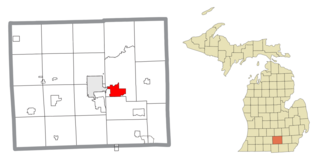
Michigan Center is an unincorporated community and census-designated place (CDP) in Jackson County in the U.S. state of Michigan. The population was 4,672 at the 2010 census. The CDP is located within Leoni Township on the eastern border of the city of Jackson.

<span class="mw-page-title-main">Ada Township, Michigan</span> Civil township in Michigan, United States

Ada Township is a civil township of Kent County in the U.S. state of Michigan. The population was 14,388 at the 2020 census.

<span class="mw-page-title-main">Alpine Township, Michigan</span> Civil township in Michigan, United States

Alpine Township is a civil township of Kent County in the U.S. state of Michigan. The population was 14,079 at the 2020 census.

<span class="mw-page-title-main">Byron Township, Michigan</span> Civil township in Michigan, United States

Byron Township is a civil township of Kent County in the U.S. state of Michigan. The population was 26,927 at the 2010 census, an increase from 20,317 at the 2010 census.

<span class="mw-page-title-main">Cannon Township, Michigan</span> Township in Michigan, United States

Cannon Township is a civil township of Kent County in the U.S. state of Michigan. The population was 13,336 at the 2010 census.

<span class="mw-page-title-main">Cascade Township, Michigan</span> Charter township in Michigan, United States

Cascade Charter Township is a charter township of Kent County in the U.S. state of Michigan. The population was 19,667 at the 2020 census.

<span class="mw-page-title-main">Comstock Park, Michigan</span> Census-designated place & unincorporated community in Michigan, United States

Comstock Park is an unincorporated community and census-designated place (CDP) in Kent County in the U.S. state of Michigan. The population was 10,500 at the 2020 census. The community is located within Alpine Township to the west and Plainfield Township to the east.

<span class="mw-page-title-main">Cutlerville, Michigan</span> Census-designated place & unincorporated community in Michigan, United States

Cutlerville is an unincorporated community and census-designated place (CDP) in Kent County in the U.S. state of Michigan. The population was 17,849 as of the 2020 census. The community is located mostly within Byron Township to the west with a smaller portion within Gaines Township to the east.

<span class="mw-page-title-main">Forest Hills, Michigan</span> Census-designated place & unincorporated community in Michigan, United States

Forest Hills is an unincorporated community and census-designated place (CDP) in Kent County in the U.S. state of Michigan. The population was 28,573 at the 2020 census, making it the most populous CDP in Michigan. It is also the largest CDP by area in the state of Michigan, encompassing nearly all of Ada Township and most of the northern half of Cascade Township. The Forest Hills Public Schools District serves most of the community.

<span class="mw-page-title-main">Grand Rapids Charter Township, Michigan</span> Charter township in Michigan, United States

Grand Rapids Charter Township is a charter township of Kent County in the U.S. state of Michigan. The population was 18,905 at the 2020 census.

<span class="mw-page-title-main">Oakfield Township, Michigan</span> Civil township in Michigan, United States

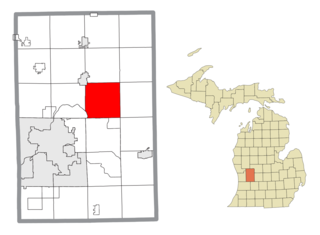
Oakfield Township is a civil township of Kent County in the U.S. state of Michigan. The population was 6,107 at the 2020 census. It is part of the Grand Rapids metropolitan area and is located about 20 miles (32 km) northeast of the city of Grand Rapids.

<span class="mw-page-title-main">Sparta Township, Michigan</span> Civil township in Michigan, United States

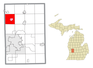
Sparta Township is a civil township of Kent County in the U.S. state of Michigan. The population was 9,395 at the 2020 census.

<span class="mw-page-title-main">Allendale, Michigan</span> Census-designated place & unincorporated community in Michigan, United States

Allendale is a census-designated place (CDP) in Ottawa County in the U.S. state of Michigan. The population was 17,579 at the 2010 census. It is located within Allendale Charter Township, occupying approximately the northern two-thirds of the township, from the eastern boundary with the Grand River west along Pierce St., north along 75th Ave., then west along Lake Michigan Drive (M-45) to the western boundary of the township. It is a part of the Grand Rapids-Muskegon-Holland, Michigan combined statistical area, and is an exurb of Grand Rapids, due to its major commuter routes into the city.

<span class="mw-page-title-main">Jenison, Michigan</span> Census-designated place & unincorporated community in Michigan, United States

Jenison is a census-designated place (CDP) in Ottawa County in the U.S. state of Michigan. The community is located within Georgetown Charter Township. The population of the CDP was 17,211 as of the 2000 census. The current estimated population for the entire Jenison ZIP code, 49428, is 25,770. The geographical boundaries of the ZIP code are larger than that of the CDP.

<span class="mw-page-title-main">Grand Rapids metropolitan area</span> Metropolitan area in Michigan, United States

The Grand Rapids metropolitan area is a triangular shaped Metro Triplex, in West Michigan, which fans out westward from the primary hub city of Grand Rapids, Michigan, to the other two metro hubs of Muskegon and Holland. The metropolitan area had an estimated population of 1,059,113 in 2017. The region, noted in particular for its western edge abutting the Lake Michigan shoreline and its beaches, is a popular tourist and vacation destination during the summer. Noted popular metro area beach towns include Grand Haven, Holland, Muskegon, and Saugatuck.

<span class="mw-page-title-main">Gaines Township, Kent County, Michigan</span> Charter township in Michigan, United States

Gaines Charter Township is a charter township of Kent County in the U.S. state of Michigan. The population was 28,812 at the 2020 census. The township is part of the Grand Rapids metropolitan area and is located about 3.0 miles (4.8 km) south of the city of Grand Rapids.

<span class="mw-page-title-main">Plainfield Township, Kent County, Michigan</span> Charter township in Michigan, United States

Plainfield Charter Township is a charter township of Kent County in the U.S. state of Michigan. The population was 33,535 at the 2020 census.

<span class="mw-page-title-main">Tyrone Township, Kent County, Michigan</span> Civil township in Michigan, United States

Tyrone Township is a civil township of Kent County in the U.S. state of Michigan. As of the 2020 census, the township had a total population of 5,021.

References

  1. "2020 U.S. Gazetteer Files". United States Census Bureau. Retrieved May 21, 2022.
  2. 1 2 "U.S. Census website". United States Census Bureau . Retrieved January 31, 2008.
  3. U.S. Geological Survey Geographic Names Information System: Northview, Michigan
  4. 1 2 "Michigan: 2010 Population and Housing Unit Counts 2010 Census of Population and Housing" (PDF). 2010 United States Census . United States Census Bureau. September 2012. p. 28 Michigan. Archived (PDF) from the original on October 19, 2012. Retrieved October 1, 2021.
  5. Northview CDP, Michigan - Reference Map - American FactFinder [ permanent dead link ], U.S. Census Bureau, 2000 census
  6. Northview District map [ permanent dead link ]
  7. "U.S. Census website". United States Census Bureau . Retrieved May 9, 2024.
  8. "Census of Population and Housing". Census.gov. Retrieved June 4, 2016.