Kent City, Michigan

Last updated

Kent City, Michigan
Village of Kent City
Kent City, MI location.png
Location within Kent County
USA Michigan location map.svg
Red pog.svg
Kent City
Location within the state of Michigan
Usa edcp location map.svg
Red pog.svg
Kent City
Location within the United States
Coordinates: 43°13′09″N85°45′13″W / 43.21917°N 85.75361°W / 43.21917; -85.75361
CountryUnited States
State Michigan
County Kent
Township Tyrone
Incorporated1908
Government
  Type Village council
  PresidentBert Rose
   Clerk Ashley Scudder
Area
[1]
  Total1.34 sq mi (3.47 km2)
  Land1.34 sq mi (3.47 km2)
  Water0.00 sq mi (0.00 km2)
Elevation
810 ft (247 m)
Population
 (2020)
  Total1,262
  Density942.49/sq mi (363.79/km2)
Time zone UTC-5 (Eastern (EST))
  Summer (DST) UTC-4 (EDT)
ZIP code(s)
49330
Area code 616
FIPS code 26-42780 [2]
GNIS feature ID0629599 [3]
Website Official website

Kent City is a village in Kent County in the U.S. state of Michigan. The population was 1,262 at the 2020 census. The village is located within Tyrone Township.

Contents

The village is part of the Grand Rapids metropolitan area and is located about 20 miles (32.2 km) north of the city of Grand Rapids.

Geography

According to the U.S. Census Bureau, the village has a total area of 1.34 square miles (3.47 km2), all land. [4]

Major highways

Climate

This climatic region is typified by large seasonal temperature differences, with warm to hot (and often humid) summers and cold (sometimes severely cold) winters. According to the Köppen Climate Classification system, Kent City has a humid continental climate, abbreviated "Dfb" on climate maps. [5]

Education

The village of Kent City is served by Kent City Community Schools, which serves a much larger area including several townships in Kent County and smaller areas extending west into Muskegon County and Ottawa County. [6] The district is headquartered in Kent City and includes Kent City High School, Kent City Middle School, and Kent City Elementary School within its boundaries.

The Tyrone Township Branch of the Kent District Library is located in Kent City.

Demographics

Historical population
CensusPop.Note
1910 467
1920 428−8.4%
1930 48413.1%
1940 440−9.1%
1950 50615.0%
1960 61721.9%
1970 68611.2%
1980 86025.4%
1990 8994.5%
2000 1,06118.0%
2010 1,057−0.4%
2020 1,26219.4%
U.S. Decennial Census [7]

2020 census

As of the 2020 United States census [8] , the village had a population of 1,262 people. The racial makeup was 90.5% White, 1.3% Black, 0% Asian, 0% Native American, and 5.6% from two or more races. Hispanic or Latino people of any race were 22.6% of the population.

2010 census

As of the census [9] of 2010, there were 1,057 people, 373 households, and 268 families living in the village. The population density was 800.8 inhabitants per square mile (309.2/km2). There were 407 housing units at an average density of 308.3 per square mile (119.0/km2). The racial makeup of the village was 88.8% White, 0.9% African American, 0.3% Native American, 0.2% Asian, 7.7% from other races, and 2.1% from two or more races. Hispanic or Latino of any race were 17.8% of the population.

There were 373 households, of which 43.7% had children under the age of 18 living with them, 49.9% were married couples living together, 14.2% had a female householder with no husband present, 7.8% had a male householder with no wife present, and 28.2% were non-families. 23.6% of all households were made up of individuals, and 7% had someone living alone who was 65 years of age or older. The average household size was 2.83 and the average family size was 3.33.

The median age in the village was 30.6 years. 30.7% of residents were under the age of 18; 9.8% were between the ages of 18 and 24; 28.9% were from 25 to 44; 22.8% were from 45 to 64; and 7.7% were 65 years of age or older. The gender makeup of the village was 48.2% male and 51.8% female.

2000 census

As of the census [2] of 2000, there were 1,061 people, 373 households, and 270 families living in the village. The population density was 969.2 inhabitants per square mile (374.2/km2). There were 392 housing units at an average density of 358.1 per square mile (138.3/km2). The racial makeup of the village was 94.82% White, 0.28% African American, 0.19% Native American, 3.20% from other races, and 1.51% from two or more races. Hispanic or Latino of any race were 11.88% of the population.

There were 373 households, out of which 46.1% had children under the age of 18 living with them, 50.9% were married couples living together, 15.8% had a female householder with no husband present, and 27.6% were non-families. 23.9% of all households were made up of individuals, and 8.6% had someone living alone who was 65 years of age or older. The average household size was 2.84 and the average family size was 3.33.

In the village, the population was spread out, with 34.0% under the age of 18, 11.5% from 18 to 24, 29.6% from 25 to 44, 16.2% from 45 to 64, and 8.7% who were 65 years of age or older. The median age was 28 years. For every 100 females, there were 90.5 males. For every 100 females age 18 and over, there were 87.2 males.

The median income for a household in the village was $35,341, and the median income for a family was $42,375. Males had a median income of $33,750 versus $24,167 for females. The per capita income for the village was $13,084. About 11.1% of families and 12.0% of the population were below the poverty line, including 15.0% of those under age 18 and 14.1% of those age 65 or over.

Superfund site

The Kent City Mobile Home Park was listed as a federal Superfund Site. A buried 55-gallon drum containing dry cleaning chemicals contaminated both the surrounding soil and groundwater, including the well servicing the mobile home park. [10] Cleanup efforts began in 1984 and included replacing the contaminated well, removing the drum and the contaminated soil, and ongoing groundwater monitoring. [11] The United States Environmental Protection Agency removed the site's Superfund status in 1995. [11]

Related Research Articles

<span class="mw-page-title-main">Ladonia, Alabama</span> Census-designated place & Unincorporated community in Alabama, United States

Ladonia is an unincorporated community and census-designated place (CDP) in Russell County, Alabama, United States. At the 2020 census, the population was 3,074. It is part of the Columbus, Georgia-Alabama, Metropolitan Statistical Area.

<span class="mw-page-title-main">Sand Lake, Michigan</span> Village in Michigan, United States

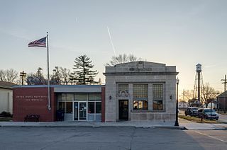
Sand Lake is a village in Kent County in the U.S. state of Michigan. The population was 522 at the 2020 census.

<span class="mw-page-title-main">Orchard Lake Village, Michigan</span> City in Michigan, United States

The City of Orchard Lake Village is a city in Oakland County in the U.S. state of Michigan. A northern suburb of Detroit, Orchard Lake Village is located roughly 27 miles (43.5 km) from downtown Detroit, and about 3 miles (4.8 km) southwest of Pontiac. The city is mostly surrounded by West Bloomfield Township, with a small northeast border with Keego Harbor. As of the 2010 census, the city had a population of 2,375.

<span class="mw-page-title-main">Elizabeth, Minnesota</span> City in Minnesota, United States

Elizabeth is a city in Otter Tail County, Minnesota, United States. The population was 168 at the 2020 census.

<span class="mw-page-title-main">Urich, Missouri</span> City in Missouri, United States

Urich is a city in Henry County, Missouri, United States. The population was 505 at the 2010 census.

<span class="mw-page-title-main">Country Club Hills, Missouri</span> City in Missouri, United States

Country Club Hills is a city in St. Louis County, Missouri, United States. The population was 1,274 at the 2010 census.

<span class="mw-page-title-main">Northwoods, Missouri</span> City in Missouri, United States

Northwoods is a city in St. Louis County, Missouri, United States. The population was 4,227 at the 2010 census.

<span class="mw-page-title-main">Mead, Nebraska</span> Village in Saunders County, Nebraska, United States

Mead is a village in Saunders County, Nebraska, United States. The population was 617 at the 2020 census.

<span class="mw-page-title-main">Moreland Hills, Ohio</span> Village in Ohio, United States

Moreland Hills is a village in eastern Cuyahoga County, Ohio, United States. The population was 3,466 at the 2020 census. An eastern suburb of Cleveland, it is part of the Cleveland metropolitan area.

<span class="mw-page-title-main">Valley View, Ohio</span> Village in Ohio, United States

Valley View is a village in Cuyahoga County, Ohio, United States. The population was 1,897 at the 2020 census. A suburb of Cleveland, it is a part of the Cleveland metropolitan area.

<span class="mw-page-title-main">Millersport, Ohio</span> Village in Ohio, United States

Millersport is a village in Fairfield County, Ohio, United States. The population was 978 at the 2020 census. Millersport is most notable as the home of the Sweet Corn Festival, which is held in Millersport annually during the first week of September.

<span class="mw-page-title-main">Whitehouse, Ohio</span> Village in Ohio, United States

Whitehouse is a village within the Toledo Metropolitan Area in Lucas County, Ohio, United States. The population was 4,990 at the 2020 census.

<span class="mw-page-title-main">Montezuma, Ohio</span> Village in Ohio, United States

Montezuma is a village in Mercer County, Ohio, United States. The population was 152 at the 2020 census.

<span class="mw-page-title-main">Kingston, Ohio</span> Village in Ohio, United States

Kingston is a village in Ross County, Ohio, United States. The population was 1,262 at the 2020 census.

<span class="mw-page-title-main">North Canton, Ohio</span> City in Ohio, United States

North Canton is a city in central Stark County, Ohio, United States. The population was 17,842 at the 2020 census. It is a suburb of the Canton–Massillon metropolitan area.

<span class="mw-page-title-main">Tuscarawas, Ohio</span> Village in Ohio, United States

Tuscarawas, originally Trenton, is a village in Tuscarawas County, Ohio, United States. The population was 1,035 at the 2020 census.

<span class="mw-page-title-main">Frederic, Wisconsin</span> Village in Wisconsin, United States

Frederic is a village in Polk County, Wisconsin, United States. The population was 1,137 at the 2010 census. It was established as a village in 1901.

<span class="mw-page-title-main">Whiting, Wisconsin</span> Village in Wisconsin, United States

Whiting is a village in Portage County, Wisconsin, United States and is a suburb of Stevens Point. It is included in the Stevens Point Micropolitan Statistical Area. The population was 1,601 at the 2020 census.

<span class="mw-page-title-main">Casnovia, Michigan</span> Village in Michigan, United States

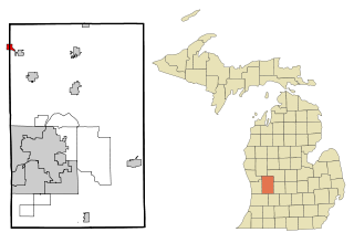
Casnovia is a village in the U.S. state of Michigan. It is situated on the boundary between Muskegon and Kent counties and lies partially within each. The population was 316 at the 2020 census.

<span class="mw-page-title-main">Theresa, Wisconsin</span> Village in Wisconsin, United States

Theresa is a village in Dodge County, Wisconsin, United States. The population was 1,262 at the 2010 census. The village is within the Town of Theresa.

References

  1. "2020 U.S. Gazetteer Files". United States Census Bureau. Retrieved May 21, 2022.
  2. 1 2 "U.S. Census website". United States Census Bureau . Retrieved January 31, 2008.
  3. "US Board on Geographic Names". United States Geological Survey. October 25, 2007. Retrieved January 31, 2008.
  4. "2019 U.S. Gazetteer Files". United States Census Bureau. Retrieved July 25, 2020.
  5. Climate Summary for Kent City, Michigan
  6. Michigan Geographic Framework (November 15, 2013). "Kent County School Districts" (PDF). Archived (PDF) from the original on August 20, 2014. Retrieved September 28, 2021.
  7. "Census of Population and Housing". Census.gov. Retrieved June 4, 2015.
  8. "Zip Atlas website". Zip Atlas . Retrieved May 9, 2024.
  9. "U.S. Census website". United States Census Bureau . Retrieved November 25, 2012.
  10. "KENT CITY MOBILE HOME PARK Site Profile". cumulis.epa.gov. Retrieved February 22, 2019.
  11. 1 2 "KENT CITY MOBILE HOME PARK: Cleanup Activities". cumulis.epa.gov. Retrieved February 22, 2019.