ArcGIS Server website depicting submersed aquatic vegetation
Geographic Information Systems (GIS) has become an integral part of aquatic science and limnology. Water by its very nature is dynamic. Features associated with water are thus ever-changing. To be able to keep up with these changes, technological advancements have given scientists methods to enhance all aspects of scientific investigation, from satellite tracking of wildlife to computer mapping of habitats. Agencies like the US Geological Survey, US Fish and Wildlife Service as well as other federal and state agencies are utilizing GIS to aid in their conservation efforts.
GIS is being used in multiple fields of aquatic science from limnology, hydrology, aquatic botany, stream ecology, oceanography and marine biology. Applications include using satellite imagery to identify, monitor and mitigate habitat loss. Imagery can also show the condition of inaccessible areas. Scientists can track movements and develop a strategy to locate locations of concern. GIS can be used to track invasive species, endangered species, and population changes.
One of the advantages of the system is the availability for the information to be shared and updated at any time through the use of web-based data collection.
GIS and fish
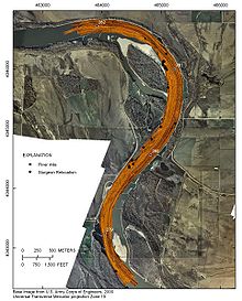
USGS sidescan radar image over base image from Army Corps of Engineers, indicating sturgeon location and river mile
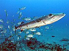
In the past, GIS was not a practical source of analysis due to the difficulty in obtaining spatial data on habitats or organisms in underwater environments. With the advancement of radio telemetry, hydroacoustic telemetry and side-scan sonar biologists have been able to track fish species and create databases that can be incorporated into a GIS program to create a geographical representation. Using radio and hydroacoustic telemetry, biologists are able to locate fish and acquire relatable data for those sites, this data may include substrate samples, temperature, and conductivity. Side-scan sonar allows biologists to map out a river bottom to gain a representation of possible habitats that are used. These two sets of data can be overlaid to delineate the distribution of fish and their habitats for fish. This method has been used in the study of the pallid sturgeon.
Over a period of time large amounts of data are collected and can be used to track patterns of migration, spawning locations and preferred habitat. Before, this data would be mapped and overlaid manually. Now this data can be entered into a GIS program and be layered, organized and analyzed in a way that was not possible to do in the past. Layering within a GIS program allows for the scientist to look at multiple species at once to find possible watersheds that are shared by these species, or to specifically choose one species for further examination. The US Geological Survey (USGS) in, cooperation with other agencies, were able to use GIS in helping map out habitat areas and movement patterns of pallid sturgeon. At the Columbia Environmental Research Center their effort relies on a customized ArcPad and ArcGIS, both ESRI (Environmental Systems Research Institute) applications, to record sturgeon movements to streamline data collection. A relational database was developed to manage tabular data for each individual sturgeon, including initial capture and reproductive physiology. Movement maps can be created for individual sturgeon. These maps help track the movements of each sturgeon through space and time. This allowed these researchers to prioritize and schedule field personnel efforts to track, map, and recapture sturgeon.
GIS and macrophytes
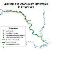
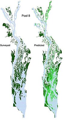
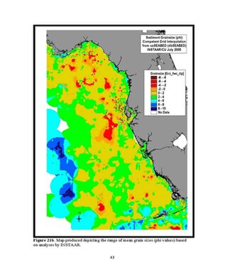
Map created from GIS database depicting the movements of individual sturgeonSurveyed (left) and predicted (right) distributions of submersed aquatic vegetation distribution Upper Mississippi River in 1989. The survey data were from the land cover/land use geographic information created by the U.S. Geological Survey Upper Midwest Environmental Sciences Center on the basis of interpretation of aerial photography of 1989.
Macrophytes are an important part of healthy ecosystems. They provide habitat, refuge, and food for fish, wildlife, and other organisms. Though natural occurring species are of great interest so are the invasive species that occur alongside these in our environment. GIS is being used by agencies and their respective resource managers as a tool to model these important macrophyte species. Through the use of GIS resource managers can assess the distributions of this important aspect of aquatic environments through a spatial and temporal scale. The ability to track vegetation change through time and space to make predictions about vegetation change are some of the many possibilities of GIS. Accurate maps of the aquatic plant distribution within an aquatic ecosystem are an essential part resource management.
It is possible to predict the possible occurrences of aquatic vegetation. For example, the USGS has created a model for the American wild celery (Vallisneria americana) by developing a statistical model that calculates the probability of submersed aquatic vegetation. They established a web link to an Environmental Systems Research Institute (ESRI) ArcGIS Server website *Submersed Aquatic Vegetation Model to make their model predictions available online. These predictions for distribution of submerged aquatic vegetation can potentially have an effect on foraging birds by creating avoidance zones by humans. If it is known where these areas are, birds can be left alone to feed undisturbed. When there are years where the aquatic vegetation is predicted to be limited in these important wildlife habitats, managers can be alerted.
Invasive species have become a great conservation concern for resource managers. GIS allows managers to map out plant locations and abundances. These maps can then be used to determine the threat of these invasive plants and help the managers decide on management strategies. Surveys of these species can be conducted and then downloaded into a GIS system. Coupled with this, native species can be included to determine how these communities respond with each other. By using known data of preexisting invasive species GIS models could predict future outbreaks by comparing biological factors. The Connecticut Agricultural Experiment Station Invasive Aquatic Species Program (CAES IAPP) is using GIS to evaluate risk factors. GIS allows managers to georeference plant locations and abundance. This allows for managers to display invasive communities alongside native species for study and management.
Aquatic plants are plants that have adapted to living in aquatic environments. They are also referred to as hydrophytes or macrophytes to distinguish them from algae and other microphytes. A macrophyte is a plant that grows in or near water and is either emergent, submergent, or floating. In lakes and rivers macrophytes provide cover for fish, substrate for aquatic invertebrates, produce oxygen, and act as food for some fish and wildlife.
Freshwater ecosystems are a subset of Earth's aquatic ecosystems. They include lakes, ponds, rivers, streams, springs, bogs, and wetlands. They can be contrasted with marine ecosystems, which have a larger salt content. Freshwater habitats can be classified by different factors, including temperature, light penetration, nutrients, and vegetation. There are three basic types of freshwater ecosystems: Lentic, lotic and wetlands. Freshwater ecosystems contain 41% of the world's known fish species.
The Florida Keys National Marine Sanctuary is a U.S. National Marine Sanctuary in the Florida Keys. It includes the Florida Reef, the only barrier coral reef in North America and the third-largest coral barrier reef in the world. It also has extensive mangrove forest and seagrass fields. The Florida Keys National Marine Sanctuary, designated in 1990, is the ninth national marine sanctuary to be established in a system that comprises 13 sanctuaries and two marine national monuments. The Florida Keys National Marine Sanctuary protects approximately 2,900 square nautical miles of coastal and ocean waters from the estuarine waters of south Florida along the Florida Keys archipelago, encompassing more than 1,700 islands, out to the Dry Tortugas National Park, reaching into the Atlantic Ocean, Florida Bay and the Gulf of Mexico.
A lake ecosystem or lacustrine ecosystem includes biotic (living) plants, animals and micro-organisms, as well as abiotic (non-living) physical and chemical interactions. Lake ecosystems are a prime example of lentic ecosystems, which include ponds, lakes and wetlands, and much of this article applies to lentic ecosystems in general. Lentic ecosystems can be compared with lotic ecosystems, which involve flowing terrestrial waters such as rivers and streams. Together, these two ecosystems are examples of freshwater ecosystems.
A scientific echosounder is a device which uses sonar technology for the calibrated backscatter measurement of underwater physical and biological components—this device is also known as scientific sonar. Applications include bathymetry, substrate classification, studies of aquatic vegetation, fish, and plankton, and differentation of water masses.
Animal migration tracking is used in wildlife biology, conservation biology, ecology, and wildlife management to study animals' behavior in the wild. One of the first techniques was bird banding, placing passive ID tags on birds legs, to identify the bird in a future catch-and-release. Radio tracking involves attaching a small radio transmitter to the animal and following the signal with a RDF receiver. Sophisticated modern techniques use satellites to track tagged animals, and GPS tags which keep a log of the animal's location. With the Emergence of IoT the ability to make devices specific to the species or what is to be tracked is possible. One of the many goals of animal migration research has been to determine where the animals are going; however, researchers also want to know why they are going "there". Researchers not only look at the animals' migration but also what is between the migration endpoints to determine if a species is moving to new locations based on food density, a change in water temperature, or other stimulus, and the animal's ability to adapt to these changes. Migration tracking is a vital tool in efforts to control the impact of human civilization on populations of wild animals, and prevent or mitigate the ongoing extinction of endangered species.
Gap analysis is a tool used in wildlife conservation to identify gaps in conservation lands or other wildlands where significant plant and animal species and their habitat or important ecological features occur.
The Yolo Bypass Wildlife Area is located within the Yolo Bypass in Yolo County, California. The wildlife area is managed by the California Department of Fish and Wildlife with the intent of restoring and managing a variety of wildlife habitats in the Yolo Basin, a natural basin in the north part of the Sacramento-San Joaquin River Delta. The creation of the wildlife area was spearheaded by the Yolo Basin Foundation. The California Department of Fish and Wildlife and Yolo Basin Foundation are the core partners in the operation of this unique community resource. Located at 38.550515°N 121.626291°W
Wetlands of the United States are defined by the United States Army Corps of Engineers and the United States Environmental Protection Agency as "those areas that are inundated or saturated by surface or ground water at a frequency and duration sufficient to support, and that under normal circumstances do support, a prevalence of vegetations typically adapted for life in saturated soils. Wetlands generally include swamps, marshes, bogs, and similar areas." Wetlands can be valued in terms of their contributions to ecological, economic and social systems. Wetlands service these systems through multiple processes including water filtration, water storage and biological productivity. They also contribute the functions of flood control, providing a nutrient sink, groundwater recharge and habitat.
A Geographic Information System is a tool for mapping and analyzing data. The ability to layer many features onto the same map and select or unselect as needed allows for a multitude of views and ease of interpreting data. More important, this allows for in depth scientific analysis and problem solving.
Wetland conservation is aimed at protecting and preserving areas of land including marshes, swamps, bogs, and fens that are covered by water seasonally or permanently due to a variety of threats from both natural and anthropogenic hazards. Some examples of these hazards include habitat loss, pollution, and invasive species. Wetland vary widely in their salinity levels, climate zones, and surrounding geography and play a crucial role in maintaining biodiversity, ecosystem services, and support human communities. Wetlands cover at least six percent of the Earth and have become a focal issue for conservation due to the ecosystem services they provide. More than three billion people, around half the world's population, obtain their basic water needs from inland freshwater wetlands. They provide essential habitats for fish and various wildlife species, playing a vital role in purifying polluted waters and mitigating the damaging effects of floods and storms. Furthermore, they offer a diverse range of recreational activities, including fishing, hunting, photography, and wildlife observation.
Species distribution modelling (SDM), also known as environmental(or ecological) niche modelling (ENM), habitat modelling, predictive habitat distribution modelling, and range mapping uses computer algorithms to predict the distribution of a species across geographic space and time using environmental data. The environmental data are most often climate data (e.g. temperature, precipitation), but can include other variables such as soil type, water depth, and land cover. SDMs are used in several research areas in conservation biology, ecology and evolution. These models can be used to understand how environmental conditions influence the occurrence or abundance of a species, and for predictive purposes (ecological forecasting). Predictions from an SDM may be of a species’ future distribution under climate change, a species’ past distribution in order to assess evolutionary relationships, or the potential future distribution of an invasive species. Predictions of current and/or future habitat suitability can be useful for management applications (e.g. reintroduction or translocation of vulnerable species, reserve placement in anticipation of climate change).
Potamogeton diversifolius is a species of aquatic plant known by the common names waterthread pondweed and diverse-leaved pondweed. It is native to most of the United States, as well as sections of southwestern Canada, and northern Mexico, where it grows in water bodies such as ponds, lakes, ditches, and slow-moving streams. This is a perennial herb producing a very narrow, compressed stem branching to a maximum length around 35 centimeters. It has thin, pointed linear leaves a few centimeters long spirally arranged about the thin stem. The inflorescence is a small spike of flowers emerging from the water surface. Inflorescences also grow on submersed sections of the stem; these are smaller and spherical. It can be difficult to distinguish from similar species of pondweed.
Invasive species are a significant threat to many native habitats and species of the United States and a significant cost to agriculture, forestry, and recreation. The term "invasive species" can refer to introduced/naturalized species, feral species, or introduced diseases. Some introduced species, such as the dandelion, do not cause significant economic or ecologic damage and are not widely considered as invasive. Economic damages associated with invasive species' effects and control costs are estimated at $120 billion per year.
Zizania texana is a rare species of grass known by the common name Texas wild rice. It is endemic to Texas, where it is found only on the upper San Marcos River in Hays County. It is threatened by the loss and degradation of its habitat. It is a federally listed endangered species of the United States.
Widgeon Valley National Wildlife Area is a National Wildlife Area located near the south end of Pitt Lake in British Columbia, Canada. The property was purchased by the Nature Trust of British Columbia in 1973 and declared a National Wildlife Area by the Canadian Wildlife Service in October of that year. The Widgeon Valley National Wildlife Area is a biologically diverse marsh wetland. It is the traditional territory of various First Nations groups. The Widgeon Valley Wildlife Area is a protected wildlife area that is home to a number of sensitive waterfowl and fish species. The public uses the channels through the Widgeon Valley National Wildlife Area for recreational canoeing, anywhere else within the protected area is strictly off-limits to the public. There are future plans to develop interpretive trails through the park and open it to the public.
Garden waste, or green waste dumping is the act of discarding or depositing garden waste somewhere it does not belong.
Aquatic plant management involves the science and methodologies used to control invasive and non-invasive aquatic plant species in waterways. Methods used include spraying herbicide, biological controls, mechanical removal as well as habitat modification. Preventing the introduction of invasive species is ideal.
Lake Namakagon is located in Bayfield County, Wisconsin. The lake is a large freshwater drainage lake that opens inlet and outlet of streams located between Lake Superior and Mississippi River system. The lake is located in the upper Namekagon river watershed as St. Croix river basin is the subwatershed of it. The lake derives its name from the Ojibwe language, and it means "Lake abundant with sturgeons." It is known for tourism and was the home of the legendary Anishinaabe Chief Namakagon.
Ecohydraulics is an interdisciplinary science studying the hydrodynamic factors that affect the survival and reproduction of aquatic organisms and the activities of aquatic organisms that affect hydraulics and water quality. Considerations include habitat maintenance or development, habitat-flow interactions, and organism responses. Ecohydraulics assesses the magnitude and timing of flows necessary to maintain a river ecosystem and provides tools to characterize the relation between flow discharge, flow field, and the availability of habitat within a river ecosystem. Based on this relation and insights into the hydraulic conditions optimal for different species or communities, ecohydraulics-modeling predicts how hydraulic conditions in a river change, under different development scenarios, the aquatic habitat of species or ecological communities. Similar considerations also apply to coastal, lake, and marine eco-systems.
This page is based on this Wikipedia article Text is available under the CC BY-SA 4.0 license; additional terms may apply. Images, videos and audio are available under their respective licenses.