Upland and lowland are conditional descriptions of a plain based on elevation above sea level. In studies of the ecology of freshwater rivers, habitats are classified as upland or lowland.
Upland and lowland are conditional descriptions of a plain based on elevation above sea level. In studies of the ecology of freshwater rivers, habitats are classified as upland or lowland.
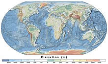
Upland and lowland are portions of plain that are conditionally categorized by their elevation above the sea level. Lowlands are usually no higher than 200 m (660 ft), while uplands are somewhere around 200 m (660 ft) to 500 m (1,600 ft). On unusual occasions, certain lowlands such as the Caspian Depression lie below sea level. [1] Uplands areas tend to spike into valleys and mountains, forming mountain ranges while lowland areas tend to be uniformly flat, although both can vary such as the Mongolian Plateau. [2]
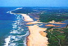
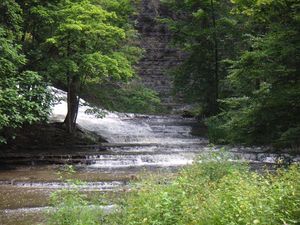
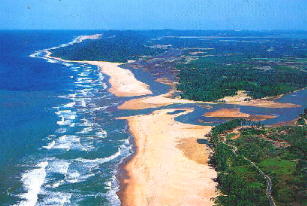
Upland habitats are cold, clear and rocky whose rivers are fast-flowing in mountainous areas; lowland habitats are warm with slow-flowing rivers found in relatively flat lowland areas, with water that is frequently colored by sediment and organic matter. [3] [4]
These classifications overlap with the geological definitions of "upland" and "lowland". In geology an "upland" is generally considered to be land that is at a higher elevation than the alluvial plain or stream terrace, which are considered to be "lowlands". The term "bottomland" refers to low-lying alluvial land near a river.
Much freshwater fish and invertebrate communities around the world show a pattern of specialization into upland or lowland river habitats. Classifying rivers and streams as upland or lowland is important in freshwater ecology, as the two types of river habitat are very different, and usually support very different populations of fish and invertebrate species.
In freshwater ecology, upland rivers and streams are the fast-flowing rivers and streams that drain elevated or mountainous country, often onto broad alluvial plains (where they become lowland rivers). However, elevation is not the sole determinant of whether a river is upland or lowland. Arguably the most important determinants are those of stream power and stream gradient. Rivers with a course that drops rapidly in elevation will have faster water flow and higher stream power or "force of water". This in turn produces the other characteristics of an upland river—an incised course, a river bed dominated by bedrock and coarse sediments, a riffle and pool structure and cooler water temperatures. Rivers with a course that drops in elevation very slowly will have slower water flow and lower force. This in turn produces the other characteristics of a lowland river—a meandering course lacking rapids, a river bed dominated by fine sediments and higher water temperatures. Lowland rivers tend to carry more suspended sediment and organic matter as well, but some lowland rivers have periods of high water clarity in seasonal low-flow periods. [5]
The generally clear, cool, fast-flowing waters and bedrock and coarse sediment beds of upland rivers encourage fish species with limited temperature tolerances, high oxygen needs, strong swimming ability and specialised reproductive strategies to prevent eggs or larvae being swept away. These characteristics also encourage invertebrate species with limited temperature tolerances, high oxygen needs and ecologies revolving around coarse sediments and interstices or "gaps" between those coarse sediments.
The term "upland" is also used in wetland ecology, where "upland" plants indicate an area that is not a wetland. [6]

The generally more turbid, warm, slow-flowing waters and fine sediment beds of lowland rivers encourage fish species with broad temperature tolerances and greater tolerances to low oxygen levels, and life history and breeding strategies adapted to these and other traits of lowland rivers. These characteristics also encourage invertebrate species with broad temperature tolerances and greater tolerances to low oxygen levels and ecologies revolving around fine sediments or alternative habitats such as submerged woody debris ("snags") or submergent macrophytes ("water weed"). [7]
Lowland alluvial plains form when there is deposition of sediment over a long period of time by one or more rivers coming from highland regions, and then are deposited in lowland regions for long periods of time. Examples include American Bottom a flood plain of the Mississippi River in Southern Illinois, Bois Brule Bottom, and Bottomland hardwood forest a deciduous hardwood forest found in broad lowland floodplains of the United States.

In geography, a plain, commonly known as flatland, is a flat expanse of land that generally does not change much in elevation, and is primarily treeless. Plains occur as lowlands along valleys or at the base of mountains, as coastal plains, and as plateaus or uplands. Plains are one of the major landforms on earth, being present on all continents and covering more than one-third of the world's land area. Plains in many areas are important for agriculture. There are various types of plains and biomes on them.

An estuary is a partially enclosed coastal body of brackish water with one or more rivers or streams flowing into it, and with a free connection to the open sea. Estuaries form a transition zone between river environments and maritime environments and are an example of an ecotone. Estuaries are subject both to marine influences such as tides, waves, and the influx of saline water, and to fluvial influences such as flows of freshwater and sediment. The mixing of seawater and freshwater provides high levels of nutrients both in the water column and in sediment, making estuaries among the most productive natural habitats in the world.

A wetland is a distinct ecosystem that is flooded or saturated by water, either permanently for years or decades or seasonally for a shorter periods. Flooding results in oxygen-free anoxic processes prevailing, especially in the soils. The primary factor that distinguishes wetlands from terrestrial land forms or water bodies is the characteristic vegetation of aquatic plants, adapted to the unique anoxic hydric soils. Wetlands are considered among the most biologically diverse of all ecosystems, serving as home to a wide range of plant and animal species. Methods for assessing wetland functions, wetland ecological health, and general wetland condition have been developed for many regions of the world. These methods have contributed to wetland conservation partly by raising public awareness of the functions some wetlands provide. Constructed wetlands are designed and built to treat municipal and industrial wastewater as well as to divert stormwater runoff. Constructed wetlands may also play a role in water-sensitive urban design.

Aquatic plants are plants that have adapted to living in aquatic environments. They are also referred to as hydrophytes or macrophytes to distinguish them from algae and other microphytes. A macrophyte is a plant that grows in or near water and is either emergent, submergent, or floating. In lakes and rivers, macrophytes provide cover for fish, substrate for aquatic invertebrates, produce oxygen, and act as food for some fish and wildlife.

A marsh is — according to ecological definitions — a wetland that is dominated by herbaceous rather than woody plant species. More in general, the word can be used for any low-lying and seasonally waterlogged terrain. In Europe and in agricultural literature low-lying meadows that require draining and embanked polderlands are also referred to as marshes or marshland.
Freshwater ecosystems are a subset of Earth's aquatic ecosystems. They include lakes, ponds, rivers, streams, springs, bogs, and wetlands. They can be contrasted with marine ecosystems, which have a larger salt content. Freshwater habitats can be classified by different factors, including temperature, light penetration, nutrients, and vegetation. There are three basic types of freshwater ecosystems: Lentic, lotic and wetlands. Freshwater ecosystems contain 41% of the world's known fish species.
An aquatic ecosystem is an ecosystem found in and around a body of water, in contrast to land-based terrestrial ecosystems. Aquatic ecosystems contain communities of organisms—aquatic life—that are dependent on each other and on their environment. The two main types of aquatic ecosystems are marine ecosystems and freshwater ecosystems. Freshwater ecosystems may be lentic ; lotic ; and wetlands.

Chalk streams are rivers that rise from springs in landscapes with chalk bedrock. Since chalk is permeable, water percolates easily through the ground to the water table and chalk streams therefore receive little surface runoff. As a result, the water in the streams contains little organic matter and sediment and is generally very clear.

River ecosystems are flowing waters that drain the landscape, and include the biotic (living) interactions amongst plants, animals and micro-organisms, as well as abiotic (nonliving) physical and chemical interactions of its many parts. River ecosystems are part of larger watershed networks or catchments, where smaller headwater streams drain into mid-size streams, which progressively drain into larger river networks. The major zones in river ecosystems are determined by the river bed's gradient or by the velocity of the current. Faster moving turbulent water typically contains greater concentrations of dissolved oxygen, which supports greater biodiversity than the slow-moving water of pools. These distinctions form the basis for the division of rivers into upland and lowland rivers.

A lake ecosystem or lacustrine ecosystem includes biotic (living) plants, animals and micro-organisms, as well as abiotic (non-living) physical and chemical interactions. Lake ecosystems are a prime example of lentic ecosystems, which include ponds, lakes and wetlands, and much of this article applies to lentic ecosystems in general. Lentic ecosystems can be compared with lotic ecosystems, which involve flowing terrestrial waters such as rivers and streams. Together, these two ecosystems are examples of freshwater ecosystems.

Galaxias olidus, the mountain galaxias, is a species of freshwater galaxiid fish widely found in southeastern Australia.

A river is a natural flowing watercourse, usually a freshwater stream, flowing on the Earth's land surface or inside caves towards another waterbody at a lower elevation, such as an ocean, sea, bay, lake, wetland, or another river. In some cases, a river flows into the ground or becomes dry at the end of its course without reaching another body of water. Small rivers can be referred to by names such as creek, brook, and rivulet. There are no official definitions for these various generic terms for a watercourse as applied to geographic features, although in some countries or communities, a stream is customarily referred to by one of these names as determined by its size. Many names for small rivers are specific to geographic location; examples are "run" in some parts of the United States, "burn" in Scotland and Northeast England, and "beck" in Northern England. Sometimes a river is defined as being larger than a creek, but not always; the language is vague.

Freshwater biology is the scientific biological study of freshwater ecosystems and is a branch of limnology. This field seeks to understand the relationships between living organisms in their physical environment. These physical environments may include rivers, lakes, streams, ponds, lakes, reservoirs, or wetlands. Knowledge from this discipline is also widely used in industrial processes to make use of biological processes involved with sewage treatment and water purification. Water presence and flow is an essential aspect to species distribution and influences when and where species interact in freshwater environments.
Freshwater environmental quality parameters are those chemical, physical or biological parameters that can be used to characterise a freshwater body. Because almost all water bodies are dynamic in their composition, the relevant quality parameters are typically expressed as a range of expected concentrations.

The bigeye shiner is a species of ray-finned fish in the genus Notropis. This fish is a slender, silvery minnow with a dusky lateral stripe and a maximum total length of about 80 mm (3.1 in). Its distinct characteristic is its large-diameter eyes. It is a common species in upland streams of the middle Mississippi River system. Bigeye shiners prefer warm, quiet pools with clear water and silt-free substrates. Siltation, channelization, and gravel dredging are all threats to bigeye shiner populations. During spawning season, typically late April to August, bigeye shiners have several clutches of eggs. State agencies and the EPA have both played a role in the surveying of bigeye shiner populations. Populations have decreased in Ohio due mostly to habitat destruction. In addition to habitat destruction by humans, habitat alteration of the small streams and dried pools has also had a significant effect on abundance. Rivers and streams should not be channelized or modified in any way, which is becoming an increasingly popular trend in urban locations. Agricultural areas and properties within the watershed should adhere to regulations to prevent runoff into the streams.
A drought refuge is a site that provides permanent fresh water or moist conditions for plants and animals, acting as a refuge habitat when surrounding areas are affected by drought and allowing ecosystems and core species populations to survive until the drought breaks. Drought refuges are important for conserving ecosystems in places where the effects of climatic variability are exacerbated by human activities.
The Mississippi Alluvial Plain is a Level III ecoregion designated by the Environmental Protection Agency (EPA) in seven U.S. states, though predominantly in Arkansas, Louisiana, and Mississippi. It parallels the Mississippi River from the Midwestern United States to the Gulf of Mexico.

A clearwater river is classified based on its chemistry, sediments and water colour. Clearwater rivers have a low conductivity, relatively low levels of dissolved solids, typically have a neutral to slightly acidic pH and are very clear with a greenish colour. Clearwater rivers often have fast-flowing sections.
Vulnerable waters refer to geographically isolated wetlands (GIWs) and to ephemeral and intermittent streams. Ephemeral and intermittent streams are seasonally flowing and are located in headwater position. They are the outer and smallest stems of hydrological networks. Isolated wetlands are located outside floodplain and show poor surface connection to tributaries or floodplains. Geographically isolated wetlands encompass saturated depressions that are the result of fluvial, aeolian, glacial and/or coastal geomorphological processes. They may be natural landforms or the result of human interventions. Vulnerable waters represent the major proportion of river networks.

Ecohydraulics is an interdisciplinary science studying the hydrodynamic factors that affect the survival and reproduction of aquatic organisms and the activities of aquatic organisms that affect hydraulics and water quality. Considerations include habitat maintenance or development, habitat-flow interactions, and organism responses. Ecohydraulics assesses the magnitude and timing of flows necessary to maintain a river ecosystem and provides tools to characterize the relation between flow discharge, flow field, and the availability of habitat within a river ecosystem. Based on this relation and insights into the hydraulic conditions optimal for different species or communities, ecohydraulics-modeling predicts how hydraulic conditions in a river change, under different development scenarios, the aquatic habitat of species or ecological communities. Similar considerations also apply to coastal, lake, and marine eco-systems.