Harpswell, Maine

Last updated

Harpswell, Maine
View HarpswellME.jpg
Lookout Point
Cumberland County Maine incorporated and unincorporated areas Harpswell highlighted.svg
Location in Cumberland County and the state of Maine.
Coordinates: 43°47′9″N69°57′27″W / 43.78583°N 69.95750°W / 43.78583; -69.95750
Country United States
State Maine
County Cumberland
Incorporated (district)1758
Incorporated (town)August 23, 1775
Villages Bailey Island
Cundys Harbor
Harpswell Center
Dyer Cove
East Harpswell
North Harpswell
Orrs Island
South Harpswell
West Harpswell
Area
[1]
  Total127.69 sq mi (330.72 km2)
  Land24.18 sq mi (62.63 km2)
  Water103.51 sq mi (268.09 km2)
Elevation
39 ft (12 m)
Population
 (2020)
  Total5,031
  Density208/sq mi (80.3/km2)
Time zone UTC-5 (Eastern (EST))
  Summer (DST) UTC-4 (EDT)
ZIP codes
04003, 04066, 04079
Area code 207 Exchange
FIPS code 23-31390
GNIS feature ID0582511
Website www.harpswell.maine.gov

Harpswell is a town in Cumberland County, Maine, United States, within Casco Bay in the Gulf of Maine. The population was 5,031 at the 2020 census. [2] Harpswell is composed of land contiguous with the rest of Cumberland County, called Harpswell Neck, as well as three large islands connected by bridges: Sebascodegan Island (locally known as Great Island), Orr's Island, and Bailey Island and over 200 smaller islands. Harpswell is part of the Portland South Portland Biddeford, Maine Metropolitan Statistical Area.

Contents

History

The Native Americans who originally inhabited Harpswell were part of the Abenaki. The Abenaki name for Harpswell Neck, then called West Harpswell, was Merriconeag or "quick carrying place", a reference to the narrow peninsula's easy portage. The Abenaki name for Great Island was Erascohegan or Sebascodiggin, [3] which became by the late 1800s Sebascodegan Island. About 1659 Major Nicholas Shapleigh of Kittery, Maine, bought Merriconeag and Sebascodegan Island from the Abenaki, but because of Indian defense, attempts to settle the area were abandoned until after Dummer's War. The Treaty of 1725 brought a truce, and by 1731 many settlers had returned. [4]

Formerly a part of North Yarmouth, in 1758 the town was incorporated by the Massachusetts General Court and named for Harpswell in Lincolnshire, England. [5] Industries included farming and some shipbuilding, but fishing brought considerable profit, and lobstering still contributes to the local economy.[ citation needed ] The Bailey Island Bridge is a National Historic Civil Engineering Landmark.

Geography

According to the United States Census Bureau, the town has a total area of 127.69 square miles (330.72 km2), of which 24.18 square miles (62.63 km2) is land and 103.51 square miles (268.09 km2) is water. [1] The town is situated on Casco Bay in the Gulf of Maine, part of the Atlantic Ocean. Harpswell has about 216 miles (348 km) of coastline. [6]

The town is crossed by state routes 24 and 123. It is bordered by the town of Brunswick to the north, and is separated by the New Meadows River from West Bath to the northeast and Phippsburg to the east.

Demographics

Historical population
CensusPop.Note
1790 1,071
1800 1,049−2.1%
1810 1,19013.4%
1820 1,2535.3%
1830 1,3527.9%
1840 1,4487.1%
1850 1,5345.9%
1860 1,6034.5%
1870 1,7499.1%
1880 1,7731.4%
1890 1,766−0.4%
1900 1,750−0.9%
1910 1,650−5.7%
1920 1,242−24.7%
1930 1,3649.8%
1940 1,305−4.3%
1950 1,64426.0%
1960 2,03223.6%
1970 2,55225.6%
1980 3,79648.7%
1990 5,01232.0%
2000 5,2394.5%
2010 4,740−9.5%
2020 5,0316.1%
U.S. Decennial Census [7]
The causeway to Potts Point in 1914 The Bridge to South Harpswell, ME.jpg
The causeway to Potts Point in 1914

2010 census

As of the census [8] of 2010, there were 4,740 people, 2,218 households, and 1,450 families living in the town. The population density was 196.0 inhabitants per square mile (75.7/km2). There were 4,208 housing units at an average density of 174.0 per square mile (67.2/km2). The racial makeup of the town was 97.7% White, 0.1% African American, 0.3% Native American, 0.6% Asian, 0.1% from other races, and 1.3% from two or more races. Hispanic or Latino of any race were 0.8% of the population.

There were 2,218 households, of which 19.1% had children under the age of 18 living with them, 55.3% were married couples living together, 6.4% had a female householder with no husband present, 3.7% had a male householder with no wife present, and 34.6% were non-families. 27.1% of all households were made up of individuals, and 12.8% had someone living alone who was 65 years of age or older. The average household size was 2.13 and the average family size was 2.53.

The median age in the town was 52.9 years. 15% of residents were under the age of 18; 4.7% were between the ages of 18 and 24; 16.9% were from 25 to 44; 37.5% were from 45 to 64; and 25.9% were 65 years of age or older. The gender makeup of the town was 48.4% male and 51.6% female.

2000 census

As of the census [9] of 2000, there were 5,239 people, 2,340 households, and 1,532 families living in the town. The population density was 216.7 inhabitants per square mile (83.7/km2). There were 3,701 housing units at an average density of 153.1 per square mile (59.1/km2). The racial makeup of the town was 97.94% White, 0.25% African American, 0.34% Native American, 0.55% Asian, 0.23% from other races, and 0.69% from two or more races. Hispanic or Latino of any race were 1.32% of the population.

There were 2,340 households, out of which 24.0% had children under the age of 18 living with them, 56.1% were married couples living together, 6.3% had a female householder with no husband present, and 34.5% were non-families. 27.3% of all households were made up of individuals, and 10.9% had someone living alone who was 65 years of age or older. The average household size was 2.24 and the average family size was 2.69.

Ragged Island c. 1920 East Shore of Ragged Island, Harpswell, ME.jpg
Ragged Island c. 1920

In the town, the population was spread out, with 19.6% under the age of 18, 4.9% from 18 to 24, 25.1% from 25 to 44, 31.7% from 45 to 64, and 18.8% who were 65 years of age or older. The median age was 45 years. For every 100 females, there were 96.1 males. For every 100 females age 18 and over, there were 93.3 males.

The median income for a household in the town was $40,611, and the median income for a family was $45,119. Males had a median income of $34,167 versus $30,000 for females. The per capita income for the town was $30,433. About 3.3% of families and 5.6% of the population were below the poverty line, including 6.8% of those under age 18 and 3.8% of those age 65 or over.

Fire, EMS, police

Fire protection services are provided in Harpswell by three unique and nonrelated volunteer fire departments. All three departments provide EMS services and operate ambulances. A town contracted paramedic is stationed 24/7 at the town hall.

Law enforcement services are provided by the Cumberland County Sheriff's Office.

Notable people

Education

Public schools in the area are operated by Maine School Administrative District 75. During the 2010–2011 school year, Harpswell residents voted to close the West Harpswell School, one of the town's two K–5 elementary schools. Beginning in 2011–2012, West Harpswell students began being bused to the Harpswell Islands School. It was due to save approximately $200,000 a year. [12] In September 2013, Harpswell Coastal Academy, a charter school serving grades 6–12 opened in the old West Harpswell School. There is a private preschool, the Harpswell Nature School, residing within the Elijah Kellogg Church (not religiously affiliated) that was established in 2003 under the name Harpswell Community Nursery School, with four teachers and twenty-four students ages 3–5.

The fictional murder mystery Blow the Man Down was filmed in Harpswell in 2018. [13] The name of the town in the film is changed to Easter Cove, Maine.

The Marvel Comics superhero Carol Danvers has a family home in Harpswell. [14]

Sites of interest

Related Research Articles

<span class="mw-page-title-main">Cumberland County, Maine</span> County in Maine, United States

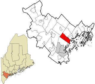
Cumberland County is a county in the U.S. state of Maine. As of the 2020 census, the population was 303,069, making it the most populous county in Maine. Its county seat is Portland. Cumberland County was founded in 1760 from a portion of York County, Province of Massachusetts Bay, and named for William, Duke of Cumberland, a son of King George II. Cumberland County has the deepest and second-largest body of water in the state, Sebago Lake, which supplies tap water to most of the county. The county is the state's economic and industrial center, having the resources of the Port of Portland, the Maine Mall, and having corporate headquarters of major companies such as Fairchild Semiconductor, IDEXX Laboratories, Unum, and TD Bank. Cumberland County is part of the Portland–South Portland, ME Metropolitan Statistical Area.

<span class="mw-page-title-main">Baldwin, Maine</span> Town in the state of Maine, United States

Baldwin is a town in Cumberland County, Maine, United States. The population was 1,520 at the 2020 census. It is part of the Portland–South Portland–Biddeford, Maine, metropolitan statistical area.

<span class="mw-page-title-main">Cumberland, Maine</span> Town in Maine, United States

Cumberland is a town in Cumberland County, Maine, United States. The population was 8,473 at the time of the 2020 census. It is part of the Portland metropolitan area, Maine. Cumberland is one of the wealthiest municipalities in the state.

<span class="mw-page-title-main">New Gloucester, Maine</span> Town in the state of Maine, United States

New Gloucester is a town in Cumberland County, Maine, United States. New Gloucester is included in the Lewiston-Auburn, Maine metropolitan New England city and town area. It is home to the Sabbathday Lake Shaker Village, the last active Shaker village in the U.S. The town's population was 5,676 at the 2020 census.

<span class="mw-page-title-main">North Yarmouth, Maine</span> Town in Maine, United States of America

North Yarmouth, officially the Town of North Yarmouth, is a town in Cumberland County, Maine, United States. North Yarmouth is included in the Lewiston-Auburn, Maine metropolitan New England city and town area. The population was 4,072 at the 2020 United States Census. It is part of the Portland–South Portland–Biddeford Metropolitan Statistical Area.

<span class="mw-page-title-main">Raymond, Maine</span> Town in the state of Maine, United States

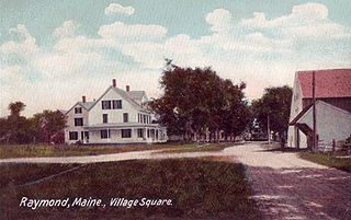
Raymond is a town in Cumberland County, Maine, United States. Raymond is included in the Lewiston-Auburn, Maine metropolitan New England city and town area. The population was 4,536 at the 2020 census. It is a summer recreation area and is part of the Portland–South Portland–Biddeford, Maine metropolitan statistical area. Raymond Neck is the landing for the ferry to the town of Frye Island in Sebago Lake. The Raymond school system is currently affiliated with the Windham school system in a district known as RSU 14.

<span class="mw-page-title-main">Standish, Maine</span> Town in the state of Maine, United States

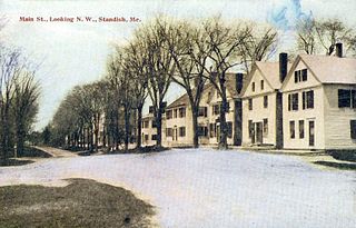
Standish is a town in Cumberland County, Maine, United States. The population was 10,244 at the 2020 census. It includes the villages of Standish Corner, Sebago Lake Village and Steep Falls, and the localities known as Richville, Elmwood, Standish Neck and Two Trails. Standish is part of the Portland-South Portland-Biddeford, Maine metropolitan statistical area.

<span class="mw-page-title-main">Boothbay, Maine</span> Town in Maine, United States

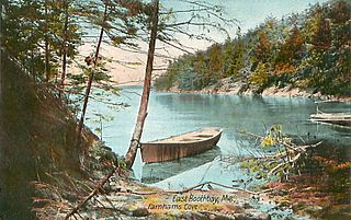
Boothbay is a town in Lincoln County, Maine, United States. The population was 3,003 at the 2020 census. It includes the neighborhoods of Back Narrows, Dover, Linekin, Oak Hill, Ocean Point, Spruce Shores, and the villages of East Boothbay and Trevett. The surrounding Boothbay Region is a center of summer tourist activity, and a significant part of its population does not live there year-round. Five shipyards are located in the town, the largest of which is Washburn & Doughty.

<span class="mw-page-title-main">Damariscotta, Maine</span> Town in the state of Maine, United States

Damariscotta is a town in Lincoln County, Maine, United States. The population was 2,297 at the 2020 census. Damariscotta is the oyster capital of New England. A popular tourist destination, the towns of Damariscotta and Newcastle are linked by the Main Street bridge over the Damariscotta River, forming the "Twin Villages". The name Damariscotta derives from a native place-name meaning place of abundance of small fish (alewives).

<span class="mw-page-title-main">Southport, Maine</span> Town in the state of Maine, United States

Southport is a town and archipelago in Lincoln County, Maine, United States. The population was 622 at the 2020 census. It includes the neighborhoods of Capitol Island, Cozy Harbor, East Side, Newagen, Pine Cliff, and West Southport, and the village of Squirrel Island. The majority of the town's residents live on its main island, Southport Island.

<span class="mw-page-title-main">Canton, Maine</span> Town in the state of Maine, United States

Canton is a town in Oxford County, Maine, United States. Canton is included in the Lewiston-Auburn, Maine metropolitan New England city and town area. The population was 1,125 at the 2020 census. Located beside Lake Anasagunticook, Canton is a summer recreational area.

Sweden is a town in Oxford County, Maine, United States. The population was 406 at the 2020 census. Set among hills, forests and ponds, Sweden includes the village of East Sweden.

<span class="mw-page-title-main">Phippsburg, Maine</span> Town in the state of Maine, United States

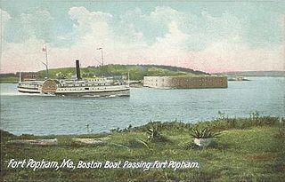
Phippsburg is a town in Sagadahoc County, Maine, United States, on the west side of the mouth of the Kennebec River. The population was 2,155 at the 2020 census. It is within the Portland–South Portland–Biddeford, Maine, metropolitan statistical area. A tourist destination, Phippsburg is home to Bates-Morse Mountain Conservation Area, Fort Popham State Historic Site; it is also home to Fort Baldwin which overlooks Fort Popham, and Popham Beach State Park, as well as Pond Island National Wildlife Refuge. The town includes part of Winnegance.

<span class="mw-page-title-main">West Bath, Maine</span> Town in the state of Maine, United States

West Bath is a town in Sagadahoc County, Maine, United States. The population was 1,910 at the 2020 census. A sub-locality of West Bath is Winnegance. West Bath is part of the Portland–South Portland–Biddeford, Maine metropolitan statistical area.

<span class="mw-page-title-main">Woolwich, Maine</span> Town in Maine, United States

Woolwich is a town in Sagadahoc County, Maine, United States. The population was 3,068 at the 2020 census. It is part of the Portland–South Portland–Biddeford, Maine metropolitan statistical area. Woolwich is a suburb of the city of Bath located on the opposite shore of Merrymeeting Bay.

<span class="mw-page-title-main">Brunswick, Maine</span> Town in Maine, United States. 04011

Brunswick is a town in Cumberland County, Maine, United States. Brunswick is included in the Lewiston-Auburn, Maine metropolitan New England city and town area. The population was 21,756 at the 2020 United States Census. Part of the Portland-South Portland-Biddeford metropolitan area, Brunswick is home to Bowdoin College, the Bowdoin International Music Festival, the Bowdoin College Museum of Art, the Peary–MacMillan Arctic Museum, and the Maine State Music Theatre. It was formerly home to the U.S. Naval Air Station Brunswick, which was permanently closed on May 31, 2011, and has since been partially released to redevelopment as "Brunswick Landing".

<span class="mw-page-title-main">Oakland, Maine</span> Town in the state of Maine, United States

Oakland is a town in Kennebec County in the U.S. state of Maine. The population was 6,230 at the 2020 census. Oakland is 4 miles (6 km) west of Waterville and approximately 18 miles (29 km) north of Augusta, the state capital. Waterville and Augusta are service centers for Oakland, and many Oakland residents commute to jobs in those areas.

<span class="mw-page-title-main">Freeport, Maine</span> Town in Maine, United States

Freeport is a town in Cumberland County, Maine, United States. Freeport is included in the Lewiston-Auburn, Maine metropolitan New England City and town area. The population was 8,737 at the 2020 census. Once home to a prominent shipbuilding industry, timber operations, and farming, it is now known for its numerous outlet stores; Freeport is home to L.L. Bean, Wolfe's Neck Woods State Park, and the Desert of Maine.

<span class="mw-page-title-main">Boothbay Harbor, Maine</span> Town in Maine, United States

Boothbay Harbor is a town in Lincoln County, Maine, United States. The population was 2,027 at the 2020 census. It includes the neighborhoods of Bayville, Mount Pisgah, and Sprucewold, and the villages of Isle of Springs and West Boothbay Harbor. During summer months, the entire Boothbay Harbor region is a popular yachting and tourist destination.

<span class="mw-page-title-main">Topsham, Maine</span> Town in the state of Maine, United States

Topsham is a town in Sagadahoc County, Maine, United States. Topsham was included in the Lewiston-Auburn, Maine metropolitan New England city and town area. The population was 9,560 at the 2020 census. It is part of the Portland–South Portland–Biddeford, Maine metropolitan statistical area. The town is home to the annual Topsham Fair.

References

  1. 1 2 "US Gazetteer files 2010". United States Census Bureau . Retrieved December 16, 2012.
  2. "Census - Geography Profile: Harpswell town, Cumberland County, Maine". United States Census Bureau . Retrieved January 13, 2022.
  3. "History of Harpswell, Maine", from A Gazetteer of the State of Maine, by Geo. J. Varney. Published by B. B. Russell, 57 Cornhill, Boston, 1886
  4. Coolidge, Austin J.; John B. Mansfield (1859). A History and Description of New England. Boston, Massachusetts: A.J. Coolidge. pp.  153–154. coolidge mansfield history description new england 1859.
  5. Maine League of Historical Societies and Museums (1970). Doris A. Isaacson (ed.). Maine: A Guide 'Down East'. Rockland, Me: Courier-Gazette, Inc. pp. 312–316.
  6. Harpswell Maine Business Association: Including Bailey Island, Orr’s Island and Cundy’s Harbor www.harpswellmaine.org, accessed August 6, 2020
  7. "Census of Population and Housing". Census.gov. Retrieved June 4, 2015.
  8. "U.S. Census website". United States Census Bureau . Retrieved December 16, 2012.
  9. "U.S. Census website". United States Census Bureau . Retrieved January 31, 2008.
  10. Koford, Henning (1938). Dr. Samuel Merritt: His Life and Achievements. Oakland, California: The Kennedy Co. Printers.
  11. Milford, Nancy. Savage Beauty: The Life of Edna St. Vincent Millay. Random House, 2001. Print. p. 269
  12. Harpswell votes to close one of its elementary schools Portland Press Herald , February 1, 2011
  13. Harpswell residents act as extras in indie film: 'Blow the Man Down' wrapped up filming in the Maine town on Friday www.pressherald.com, accessed August 6, 2020
  14. not only is aquaman from maine captain marvel is too bangordailynews.com

Further reading

Commons-logo.svg Media related to Harpswell, Maine at Wikimedia Commons