New Gloucester, Maine

Last updated

New Gloucester, Maine
Section of Shaker Village, Sabbathday Lake, ME.jpg
Sabbathday Lake Shaker Village
Motto: 
"Home of the Shaker Community" [1]
Cumberland County Maine incorporated and unincorporated areas New Gloucester highlighted.svg
Location in Cumberland County and the state of Maine.
Coordinates: 43°57′27″N70°17′42″W / 43.95750°N 70.29500°W / 43.95750; -70.29500
Country United States
State Maine
County Cumberland
Incorporated1774
Villages New Gloucester
Shaker Village
Upper Gloucester
Area
[2]
  Total47.80 sq mi (123.80 km2)
  Land47.12 sq mi (122.04 km2)
  Water0.68 sq mi (1.76 km2)
Elevation
449 ft (137 m)
Population
 (2020)
  Total5,676
  Density120/sq mi (46.5/km2)
Time zone UTC-5 (Eastern (EST))
  Summer (DST) UTC-4 (EDT)
ZIP code
04260
Area code 207
FIPS code 23-48820
GNIS feature ID0582619
Website www.newgloucester.com

New Gloucester is a town in Cumberland County, Maine, United States. New Gloucester is included in the Lewiston-Auburn, Maine metropolitan New England city and town area. It is home to the Sabbathday Lake Shaker Village, the last active Shaker village in the U.S. The town's population was 5,676 at the 2020 census. [3]

Contents

New Gloucester is part of Maine's Portland South Portland Biddeford, metropolitan statistical area.

History

New Gloucester was established in 1736 under a Massachusetts Bay Colony grant of a 6-square-mile (16 km2) tract of land in the Maine Territory to sixty inhabitants of the Gloucester fishing village on Cape Ann. The first settlers followed the road newly bushed out from North Yarmouth and built cabins on Harris Hill between 1739 and 1742. The settlement was abandoned from 1744–1751 due to the heightened native tribe attacks during King George's War. [4]

Settlers returned and in 1753 commenced work on a two-story, fifty-foot square blockhouse with a palisade stockade 110 feet (34 m) on a side. This was home to twelve families for six years. The men worked at clearing the surrounding 60 acres (240,000 m2) of common land under the protection of two swivel guns manned by a garrison of six soldiers. One attack was made upon the fort, resulting in one scalping and two men captured. As the Native Americans gradually withdrew to Canada, the settlers moved out into their own newly built homes. The blockhouse continued to serve for worship and town affairs until the first meetinghouse was built in 1773. In 1788, the blockhouse was sold at auction for seven bushels of corn and moved to a farm in the Intervale, where it was rebuilt as a hog house. [4]

New Gloucester was incorporated on March 8, 1774, [5] and was named after Gloucester, Massachusetts, the native home of a large share of the early settlers. [6]

New Gloucester became a half shire town with Portland, and the courts met here from 1791 until the organization of Oxford County in 1805, when they returned to Portland. With good soil for agriculture, the town developed as a prosperous farming community. In 1858, when the population was 1,848, other industries included six sawmills, two gristmills and two tanneries. [7]

Sabbathday Lake Shaker Village was founded in 1783 by the United Society of True Believers at what was then called Thompson's Pond Plantation. It was formally organized on April 19, 1794. Today, the village is the last of some over two-dozen religious societies, stretching from Maine to Florida, to be operated by the Shakers themselves. It comprises 18 buildings on 1,800 acres (7.3 km2) of land. [8]

Geography

According to the United States Census Bureau, the town has a total area of 47.80 square miles (123.80 km2), of which 47.12 square miles (122.04 km2) is land and 0.68 square miles (1.76 km2) is water. [2] New Gloucester is drained by the Royal River.

The town is served by Interstate 95, U.S. Route 202 and state routes 4, 26 and 231. It is bordered by the town of Raymond to the west, Poland to the northwest, the city of Auburn to the northeast, Durham to the east, Pownal and North Yarmouth to the southeast, and Gray to the southwest.

Amenities

The privately owned, unattended Cliff Dow Airport is located on Highview Drive, two miles southwest of New Gloucester, to the east of Interstate 95. Its FAA identifier is 54ME, and it was activated in 2006. Its unpaved runway headings are 5 (for landings) and 23 (for takeoffs) with an AMSL elevation of 415 feet. [9] Its area control center is Boston Center, while its flight service station is Bangor. [10]

Climate

This climatic region is typified by large seasonal temperature differences, with warm to hot (and often humid) summers and cold (sometimes severely cold) winters. According to the Köppen Climate Classification system, New Gloucester has a humid continental climate, abbreviated "Dfb" on climate maps. [11]

Climate data for New Gloucester, Maine
MonthJanFebMarAprMayJunJulAugSepOctNovDecYear
Mean daily maximum °F (°C)29.4
(−1.4)
33.5
(0.8)
41.9
(5.5)
53.6
(12.0)
65.1
(18.4)
74.0
(23.3)
79.1
(26.2)
78.5
(25.8)
70.0
(21.1)
58.0
(14.4)
45.9
(7.7)
34.8
(1.6)
54.5
(12.5)
Mean daily minimum °F (°C)12.6
(−10.8)
15.9
(−8.9)
24.0
(−4.4)
34.9
(1.6)
44.7
(7.1)
54.1
(12.3)
59.7
(15.4)
58.7
(14.8)
50.7
(10.4)
40.1
(4.5)
31.0
(−0.6)
19.8
(−6.8)
37.2
(2.9)
Average precipitation inches (mm)4.01
(102)
3.14
(80)
4.49
(114)
4.27
(108)
3.88
(99)
3.79
(96)
3.63
(92)
3.24
(82)
3.57
(91)
4.23
(107)
4.55
(116)
4.21
(107)
47.01
(1,194)
Average snowfall inches (cm)21.2
(54)
16.5
(42)
19.9
(51)
4.8
(12)
0
(0)
0
(0)
0
(0)
0
(0)
0
(0)
0.1
(0.25)
3.0
(7.6)
18.3
(46)
83.8
(213)
Source 1: [12]
Source 2: [13]

Demographics

Historical population
CensusPop.Note
1790 1,358
1800 1,3781.5%
1810 1,64919.7%
1820 1,6580.5%
1830 1,6821.4%
1840 1,94615.7%
1850 1,848−5.0%
1860 1,654−10.5%
1870 1,496−9.6%
1880 1,382−7.6%
1890 1,234−10.7%
1900 1,162−5.8%
1910 1,2285.7%
1920 1,38412.7%
1930 1,86634.8%
1940 2,33425.1%
1950 2,62812.6%
1960 3,04715.9%
1970 2,811−7.7%
1980 3,18013.1%
1990 3,91623.1%
2000 4,80322.7%
2010 5,54215.4%
2020 5,6762.4%
sources: [14] [15]

2010 census

As of the census [16] of 2010, there were 5,542 people, 2,092 households, and 1,534 families living in the town. The population density was 117.6 inhabitants per square mile (45.4/km2). There were 2,295 housing units at an average density of 48.7 per square mile (18.8/km2). The racial makeup of the town was 97.5% White, 0.3% African American, 0.1% Native American, 0.4% Asian, 0.1% from other races, and 1.6% from two or more races. Hispanic or Latino of any race were 0.8% of the population.

There were 2,092 households, of which 36.2% had children under the age of 18 living with them, 59.9% were married couples living together, 8.2% had a female householder with no husband present, 5.2% had a male householder with no wife present, and 26.7% were non-families. 18.5% of all households were made up of individuals, and 4.7% had someone living alone who was 65 years of age or older. The average household size was 2.63 and the average family size was 2.99.

The median age in the town was 39.5 years. 24.5% of residents were under the age of 18; 6.6% were between the ages of 18 and 24; 28.6% were from 25 to 44; 31.7% were from 45 to 64; and 8.5% were 65 years of age or older. The gender makeup of the town was 50.9% male and 49.1% female.

2000 census

As of the census [17] of 2000, there were 4,803 people, 1,761 households, and 1,313 families living in the town. The population density was 102.0 inhabitants per square mile (39.4/km2). There were 1,889 housing units at an average density of 40.1 per square mile (15.5/km2). The racial makeup of the town was 98.17% White, 0.23% African American, 0.06% Native American, 0.40% Asian, 0.10% Pacific Islander, 0.12% from other races, and 0.92% from two or more races. Hispanic or Latino of any race were 0.56% of the population.

There were 1,761 households, out of which 39.2% had children under the age of 18 living with them, 61.2% were married couples living together, 8.9% had a female householder with no husband present, and 25.4% were non-families. 18.6% of all households were made up of individuals, and 6.3% had someone living alone who was 65 years of age or older. The average household size was 2.71 and the average family size was 3.08.

In the town, the population was spread out, with 28.8% under the age of 18, 6.2% from 18 to 24, 35.0% from 25 to 44, 22.5% from 45 to 64, and 7.5% who were 65 years of age or older. The median age was 36 years. For every 100 females, there were 102.2 males. For every 100 females age 18 and over, there were 99.1 males.

As of a 2008 estimate, the median income for a household in the town was $60,664 and the per capita income for the town was $24,958. As of the 2000 census and the median income for a family was $57,727. Males had a median income of $35,699 versus $26,358 for females. About 4.0% of families and 5.4% of the population were below the poverty line, including 7.6% of those under age 18 and 9.3% of those age 65 or over.

Arts and culture

Sites of interest

Education

Notable people

Related Research Articles

<span class="mw-page-title-main">Durham, Maine</span> Town in the state of Maine, United States

Durham is a town in Androscoggin County, Maine, United States. The population was 4,173 at the 2020 census. It is included in both the Lewiston-Auburn, Maine Metropolitan Statistical Area and the Lewiston-Auburn, Maine Metropolitan New England City and Town Area.

<span class="mw-page-title-main">Poland, Maine</span> Town in the state of Maine, United States

Poland is a town in Androscoggin County, Maine, United States. The population was 5,906 at the 2020 census. Set among rolling hills and numerous lakes, the town is home to Range Ponds State Park, which includes hiking trails and a pristine freshwater beach. Poland is also a historic resort area. It is included in the Lewiston-Auburn, Maine metropolitan statistical area, which itself is part of the Greater Portland-Lewiston Combined Statistical Area.

<span class="mw-page-title-main">Cumberland, Maine</span> Town in Maine, United States

Cumberland is a town in Cumberland County, Maine, United States. The population was 8,473 at the time of the 2020 census. It is part of the Portland metropolitan area, Maine. Cumberland is one of the wealthiest municipalities in the state.

<span class="mw-page-title-main">Cumberland Center, Maine</span> Census-designated place in Maine, United States

Cumberland Center is a census-designated place (CDP) within the town of Cumberland in Cumberland County, Maine, United States. The population was 2,499 at the 2010 census. It is part of the Portland – South Portland – Biddeford, Maine, Metropolitan Statistical Area.

<span class="mw-page-title-main">Falmouth Foreside</span> Census-designated place in Maine, United States

Falmouth Foreside is a census-designated place (CDP) within the town of Falmouth in Cumberland County, Maine, United States. As of the 2010 census, the CDP population was 1,511. It is part of the Portland–South Portland–Biddeford, Maine Metropolitan Statistical Area.

<span class="mw-page-title-main">Gray, Maine</span> Town in the state of Maine, United States

Gray is a town in Cumberland County, Maine, United States. The population was 8,269 at the 2020 census. It is part of the Portland–South Portland–Biddeford, Maine metropolitan statistical area. and included in the Lewiston-Auburn, Maine metropolitan New England city and town area. Gray is located at the intersection of state Routes 4, 26, 100, 115, 202 and the Maine Turnpike exit 63 midway between the state's two largest cities, Portland and Lewiston. The town includes frontage on Little Sebago Lake, Crystal Lake, and Forest Lake.

<span class="mw-page-title-main">North Yarmouth, Maine</span> Town in Maine, United States of America

North Yarmouth, officially the Town of North Yarmouth, is a town in Cumberland County, Maine, United States. North Yarmouth is included in the Lewiston-Auburn, Maine metropolitan New England city and town area. The population was 4,072 at the 2020 United States Census. It is part of the Portland–South Portland–Biddeford Metropolitan Statistical Area.

<span class="mw-page-title-main">Pownal, Maine</span> Town in Maine, United States

Pownal is a town in Cumberland County, Maine, United States. Pownal was included in the Lewiston-Auburn, Maine metropolitan New England city and town area. The population was 1,566 at the 2020 census. It is part of the Portland–South Portland–Biddeford, Maine Metropolitan Statistical Area. Pownal is home to Bradbury Mountain State Park.

<span class="mw-page-title-main">Raymond, Maine</span> Town in the state of Maine, United States

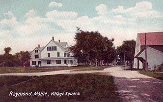
Raymond is a town in Cumberland County, Maine, United States. Raymond is included in the Lewiston-Auburn, Maine metropolitan New England city and town area. The population was 4,536 at the 2020 census. It is a summer recreation area and is part of the Portland–South Portland–Biddeford, Maine metropolitan statistical area. Raymond Neck is the landing for the ferry to the town of Frye Island in Sebago Lake. The Raymond school system is currently affiliated with the Windham school system in a district known as RSU 14.

<span class="mw-page-title-main">Sebago, Maine</span> Town in Maine, United States

Sebago is a town in Cumberland County, Maine, United States. The population was 1,911 at the 2020 census. It is part of the Portland–South Portland–Biddeford, Maine metropolitan statistical area.

<span class="mw-page-title-main">Standish, Maine</span> Town in the state of Maine, United States

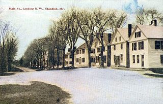
Standish is a town in Cumberland County, Maine, United States. The population was 10,244 at the 2020 census. It includes the villages of Standish Corner, Sebago Lake Village and Steep Falls, and the localities known as Richville, Elmwood, Standish Neck and Two Trails. Standish is part of the Portland-South Portland-Biddeford, Maine metropolitan statistical area.

<span class="mw-page-title-main">Wayne, Maine</span> Town in the state of Maine, United States

Wayne is a town in Kennebec County, Maine, United States. Wayne is included in the Lewiston-Auburn, Maine metropolitan New England city and town area. The population was 1,129 at the 2020 census. The town was named after Revolutionary War General Anthony Wayne. During the summer, Wayne is home to Camp Androscoggin. A popular recreation spot in central Maine, Wayne is part of the Winthrop Lakes Region. The town is included in the Augusta, Maine micropolitan New England City and Town Area. and included in the Lewiston-Auburn, Maine metropolitan New England city and town area.

<span class="mw-page-title-main">Newcastle, Maine</span> Town in the state of Maine, United States

Newcastle is a town in Lincoln County, Maine, United States. The population was 1,848 at the 2020 census. The village of Newcastle is located in the eastern part of the town, on the Damariscotta River. Together with the village of Damariscotta linked by the Main Street bridge, they form the Twin Villages.

<span class="mw-page-title-main">Hollis, Maine</span> Town in the state of Maine, United States

Hollis is a town in York County, Maine, United States. The population was 4,745 at the 2020 census. Hollis is a rural bedroom community of Portland and is part of the Portland–South Portland–Biddeford metropolitan statistical area.

<span class="mw-page-title-main">Fort Fairfield, Maine</span> Town in the state of Maine, United States

Fort Fairfield is a town in Aroostook County, eastern Maine, United States, located along the Canada–US border. The population was 3,322 at the 2020 census.

<span class="mw-page-title-main">Bridgton (CDP), Maine</span> Census-designated place in Maine, United States

Bridgton is a census-designated place (CDP) in the town of Bridgton in Cumberland County, Maine, United States. The population was 2,071 at the 2010 census. It is part of the Portland–South Portland–Biddeford, Maine Metropolitan Statistical Area.

<span class="mw-page-title-main">Bridgton, Maine</span> Town in Maine, United States 04009

Bridgton is a town in Cumberland County, Maine, United States. The population was 5,418 at the 2020 census. A resort area in Maine's Lakes Region, Bridgton is home to Bridgton Academy, a private preparatory school, and the Four on the Fourth Road Race.

<span class="mw-page-title-main">Gorham (CDP), Maine</span> Census-designated place in Maine, United States

Gorham is a census-designated place (CDP) in the town of Gorham, in Cumberland County, Maine, United States. The population was 6,882 at the 2010 census. It is part of the Portland–South Portland–Biddeford, Maine Metropolitan Statistical Area.

<span class="mw-page-title-main">Gorham, Maine</span> Town in the state of Maine, United States

Gorham is a town in Cumberland County, Maine, United States. The population was 18,336 at the 2020 United States Census. In addition to its urban village center known as Gorham Village or simply "the Village," the town encompasses a number of smaller, unincorporated villages and hamlets with distinct historical identities, including South Gorham, West Gorham, Little Falls, White Rock, and North Gorham. Gorham is home to one of the three campuses of the University of Southern Maine. In 2013, Gorham was voted second-best town in Maine after Hampden by a financial website.

<span class="mw-page-title-main">Clinton, Maine</span> Town in the state of Maine, United States

Clinton is a town in Kennebec County, Maine, United States. The town was named for New York Governor DeWitt Clinton. The population was 3,370 at the 2020 census. The main village in town is the Clinton census-designated place, with a population of 1,386 at the 2020 census.

References

  1. "Town of New Gloucester, Maine". Town of New Gloucester, Maine. Retrieved August 26, 2012.
  2. 1 2 "US Gazetteer files 2010". United States Census Bureau . Retrieved December 16, 2012.
  3. "Census - Geography Profile: New Gloucester town, Cumberland County, Maine". United States Census Bureau . Retrieved January 12, 2022.
  4. 1 2 Coolidge, Austin J.; John B. Mansfield (1859). A History and Description of New England. Boston, Massachusetts: A.J. Coolidge. pp.  225–226. coolidge mansfield history description new england 1859.
  5. "New Gloucester, Maine". City-Data.com. Retrieved August 26, 2012.
  6. Yates, Edgar A.P. (June 13, 1928). "Some Maine town names". The Lewiston Daily Sun. p. 4. Retrieved October 17, 2015.
  7. Varney, George J. (1886), History of New Gloucester, Maine, Boston, MA: B.B. Russell
  8. Sabbathday Lake Shaker Village & Museum Archived October 19, 2007, at the Wayback Machine
  9. 54ME - Metar-TAF/com
  10. 54ME Cliff Dow Airport, North Gloucester, ME - AirNav.com
  11. Climate Summary for New Gloucester, Maine
  12. "Zipcode 04260". www.plantmaps.com. Retrieved June 19, 2022.
  13. "NEW GLOUCESTER, MAINE". Weatherbase. Retrieved June 19, 2022.
  14. "Profile of General Population and Housing Characteristics: 2010 Demographic Profile Data (DP-1): New Gloucester town, Cumberland County, Maine". United States Census Bureau . Retrieved June 8, 2012.
  15. Archived September 29, 2011, at the Wayback Machine , accessed March 2010.
  16. "U.S. Census website". United States Census Bureau . Retrieved December 16, 2012.
  17. "U.S. Census website". United States Census Bureau . Retrieved January 31, 2008.
  18. "Joseph Brackett Day". American Music Preservation.com. Retrieved August 26, 2012.
  19. 'Obituary-Peleg W. Chandler,' The Post Post, May 29, 1889, pg. 4
  20. Wilson, J. G.; Fiske, J., eds. (1900). "Fessenden, Samuel"  . Appletons' Cyclopædia of American Biography . New York: D. Appleton.
  21. "Biographical Directory of the U.S. Congress - Retro Member details". bioguideretro.congress.gov. Retrieved May 1, 2020.

43°57′46″N70°16′57″W / 43.96278°N 70.28250°W / 43.96278; -70.28250