
Rampton is a village in the civil parish of Rampton and Woodbeck, about 6 miles (10 km) east of Retford in the Bassetlaw district, in the county of Nottinghamshire, England. The parish is long and thin, extending about 7 miles (11 km) east–west but only about 1 mile (1.6 km) north–south. Its eastern boundary is the River Trent, which here also forms the county boundary with Lincolnshire.
Askham is a village and civil parish in the Bassetlaw district of Nottinghamshire, England, about six miles south-east of East Retford. According to the 2001 census it had a population of 183. It decreased slightly to 181 at the 2011 Census, but has increased to 189 residents during the 2021 Census.

Beckingham is a village and civil parish in the Bassetlaw district of Nottinghamshire, England, about 3 miles west of Gainsborough, Lincolnshire. According to the 2001 census it had a population of 1,168, reducing to 1,098 in 2011 but increasing to 1,288 in 2021.

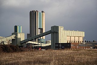
Bole is a village and civil parish in the Bassetlaw district of Nottinghamshire, England. It is close by the River Trent, on the eastern side of which is Gainsborough in Lincolnshire. At one time the village stood – like the neighbouring parish of West Burton – very near to an oxbow lake, known as Bole Round. However flooding led to the original course of the River Trent being diverted after 1792. The parish now lies within a landscape largely dominated by the West Burton power stations. According to the 2001 census Bole had a population of 140,a count of 247 at the 2011 census, and singularly reported as 135 in 2021.
Bothamsall is a village and civil parish in the Bassetlaw district of Nottinghamshire, England.

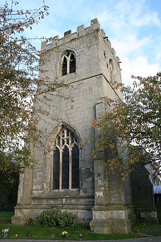
Gringley on the Hill, Nottinghamshire, is an English village and parish. The population of the civil parish at the 2011 census was 699, increasing to 854 in 2021. It is on the highest part of the road from Bawtry to Gainsborough, six miles east-southeast of the former, and the same distance west by north of the latter town.
Hayton is a village and civil parish in the East Riding of Yorkshire, England. It is situated approximately 2 miles (3 km) south of the market town of Pocklington and 4.5 miles (7 km) north-west of the market town of Market Weighton. It lies on the A1079 road.

Greasley is a civil parish north west of Nottingham in Nottinghamshire, England. Although it is thought there was once a village called Greasley, there is no settlement of that name today as it was destroyed by the Earl of Rutland. The built up areas in the parish are Beauvale, Giltbrook, Moorgreen, Newthorpe, Watnall and parts of Eastwood, Kimberley and Nuthall. There is also a small hamlet known as Bog-End. The parish is one of the largest in Nottinghamshire at 7.63 square miles (19.8 km2), the 2001 UK Census reporting it had a total population of 10,467, increasing to 11,014 in 2011, and 11,241 at the 2021 census.

Thrumpton is a village and civil parish in Nottinghamshire, England. At the time of the 2001 census it had a population of 152, increasing to 165 at the 2011 census. It is located on the A453 road 6 miles (9.7 km) south-west of West Bridgford. The 13th century Church of All Saints is Grade II* listed and was restored in 1871. Many of the gabled brick houses in the village were built between 1700 and 1745 by John Emerton of Thrumpton Hall.
Dunham-on-Trent is a village and civil parish in Nottinghamshire, England. It is located on the A57 road, about 0.5 miles (0.8 km) west of Dunham Bridge, a toll bridge crossing the River Trent.
Darlton is a small village and civil parish in Nottinghamshire, England. It is on the A57 road about 5 kilometres (3.1 mi) north-east of Tuxford.

Eaton is a village and civil parish in Nottinghamshire, England. According to the 2001 census it had a population of 105, increasing to 233 at the 2011 Census. and 111 in 2021. It is located 2 miles south of Retford, on the A638 road.

Elkesley is a village in Nottinghamshire, England. According to the 2001 census it had a population of 805, increasing to 822 at the 2011 Census, and 852 in 2021. It is located 6 miles south of Retford.
Weston is a village in Nottinghamshire, England. It is located 10 miles south of Retford. According to the 2001 census it had a population of 312, increasing to 393 at the 2011 Census. The parish church of All Saints is 13th century. At the south-east end of the village are three 16th century tenements built with cruck trusses.
Harworth Bircotes or Harworth and Bircotes is a town and civil parish in the Bassetlaw district of Nottinghamshire in the East Midlands of England. The parish includes the settlements of Bircotes and Harworth. The parish was created on 1 April 1974 out of Harworth parish.

Hayton is a village in the Cumberland unitary authority area of Cumbria, England. It is the only settlement in the civil parish of Hayton and Mealo. Historically located in Cumberland, and on a minor road between the B5300 and the A596, it is approximately 2 miles from the coast. Nearby settlements include the town of Aspatria and the villages of Oughterside and Prospect. A small tributary called Patten Beck runs across the village, through the grounds of the castle.

Warsop is a town and civil parish in Mansfield District, Nottinghamshire, England, on the outskirts of the remnants of Sherwood Forest. At the 2021 census the population was 12,644 resaidents, including Church Warsop, Meden Vale, Sookholme and Spion Kop.
Hayton and Mealo is a civil parish in Allerdale district, Cumbria. The only settlement is Hayton, a village in the centre of the parish, which had a population of 237 in the 2011 census. In 1848, its population was 378.
Clarborough and Welham is a civil parish in the Bassetlaw district, in the county of Nottinghamshire, England. The parish includes the village of Clarborough and the hamlet of Welham. In 2021 the parish had a population of 1,041. It is 130 miles north of London, 28 miles north east of the city of Nottingham, and 2 miles north east of the market town of Retford. The parish touches Hayton, North and South Wheatley, North Leverton with Habblesthorpe and Sturton Le Steeple. There are 14 listed buildings in Clarborough and Welham.
North and South Wheatley is a civil parish in the Bassetlaw district, in the county of Nottinghamshire, England. The parish includes the villages of North Wheatley and South Wheatley. In 2021 the parish had a population of 610 residents. It is 130 miles north of London, 30 miles north east of the county town of Nottingham, and 5 miles north east of the Nottinghamshire town of Retford. The parish touches Bole, Clarborough and Welham, Clayworth, Hayton, Saundby, Sturton Le Steeple and West Burton. There are 18 listed buildings in North and South Wheatley.


