The Mau Mau Uprising (1952–1960), also known as the Mau Mau Rebellion, the Kenya Emergency, and the Mau Mau Revolt, was a war in the British Kenya Colony (1920–1963) between the Kenya Land and Freedom Army (KLFA), also known as Mau Mau, and the British colonists.
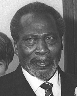
Jomo Kenyatta was a Kenyan anti-colonial activist and politician who governed Kenya as its Prime Minister from 1963 to 1964 and then as its first President from 1964 to his death in 1978. He was the country's first indigenous head of government and played a significant role in the transformation of Kenya from a colony of the British Empire into an independent republic. Ideologically an African nationalist and conservative, he led the Kenya African National Union (KANU) party from 1961 until his death.

Murang'a County is one of the counties of Kenya's former Central Province. Its largest town is Murang'a its capital, called Fort Hall in colonial times. It is inhabited mainly by and is considered the home of the Gikuyu, the largest community in Kenya. The county has a population of 1,056,640.

The North Eastern Province is one of the former provinces in Kenya. It has a land area of 127,358.5 km2, with its capital at Garissa. Previously known as the Northern Frontier District (NFD),, Now The North Eastern Province territory was carved out of the present-day southern Somalia during the colonial period. It is and has historically been exclusively inhabited by ethnic Somalis.

Josiah Mwangi Kariuki was a Kenyan socialist politician during the administration of the Jomo Kenyatta government. He held different government positions from 1963, when Kenya became an independent country, to 1975, when he was assassinated. He left behind three wives and many children. He was popularly known as "JM".

The 1,000 kilometres (620 mi) long Tana River is the longest river in Kenya, and gives its name to the Tana River County. Its tributaries include the Thika, as well as several smaller rivers that flow only during the rainy season. The river rises in the Aberdare Mountains to the west of Nyeri. Initially it runs east before turning south around the massif of Mount Kenya. The river then runs into the Masinga Reservoir and Kiambere Reservoir, created by Masinga and Kiambere dams respectively. Masinga and Kiambere reservoirs serve a dual purpose, hydro-electric power (HEP) generation and agricultural irrigation. Three further dams are located between Masinga and Kiambere, namely Kamburu, Gitaru and Kindaruma, that are used exclusively for HEP generation.

Lamu County is located in the Northern Coast of Kenya and is one of the Six Coastal Counties in Kenya. It borders Tana River County in the southwest, Garissa County to the north, Republic of Somalia to the northeast and the Indian Ocean to the South. It lies 1° 40’ and 2° 30’south and longitude 40° 15’ and 40° 38’south. The County has a land surface of 6,273.1 km that include the mainland and over 65 islands that form the Lamu Archipelago. The total length of the coastline is 130 km while land water mass area stands at 308 km.
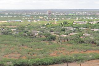
Tana River County is a county in the former Coast Province, Kenya. It is named after the Tana River. It has an area of 35,375.8 square kilometres (13,658.7 sq mi) and a population of 315,943. The capital and largest town is Hola.
The Pokomo people are a Bantu ethnic group of southeastern Kenya. The population in Kenya is currently more than 150,000. They are a distinct ethnic group with their own sub-clans/tribes. Despite their proximity, they are not of the nearby Mijikenda people. They are predominantly agriculturalists and both freshwater and ocean fishermen living along the Tana River in Tana River County. They speak the Pokomo language, which is similar to Swahili.
Kapenguria is a town lying north east of Kitale on the A1 road in Kenya. Kapenguria is capital of the West Pokot County. Kapenguria forms a municipality with an urban population of 13,000 and a total population of 56,000.

The Hola massacre is an event that took place during the Mau Mau Uprising against British colonial rule at a colonial detention camp in Hola, Kenya.
Mukurweini was a former district in Nyeri County, Kenya.
Isiolo County is a county in the former Eastern Province of Kenya. Its population is 268,002 and its capital is Isiolo. Isiolo County is to be the first county to be developed as part of the Kenya Vision 2030 program. Its capital and largest town is Isiolo. Other upcoming urban centres are: Garbatulla, Modogashe, Kinna, Merti and Oldonyiro.

Kitui County is a county in the former Eastern Province of Kenya. Its capital and largest town is Kitui, although Mwingi is also another major urban centre. The county has a population of 1,136,187. and an area of 30,430 km².
Bura is a town in Tana River County, Kenya.
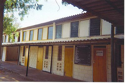
The Kapenguria Six – Bildad Kaggia, Kung'u Karumba, Jomo Kenyatta, Fred Kubai, Paul Ngei, and Achieng' Oneko – were six leading Kenyan nationalists who were arrested in 1952, tried at Kapenguria in 1952–53, and imprisoned thereafter in Northern Kenya.
The Mombasa–Garissa Road, also B8 Road (Kenya) is a major highway in Kenya, the largest economy in the East African Community. The road connects the port city of Mombasa to the inland city of Garissa. This road is composed of the Mombasa–Malindi Road and the Malindi–Garissa Road.
Garsen is a small town in Tana River County, Kenya. It is on the west bank of the Tana River.
Bura East Airport is an airport in Kenya.
Hola Airport is an airport in Kenya.